Showing 6625 items
matching 2016-01
-
 Bendigo Historical Society Inc.
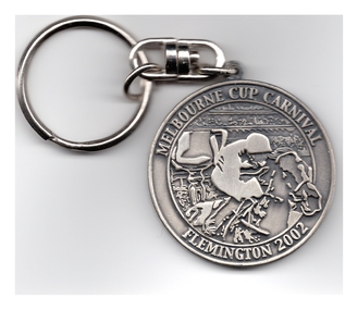
Ephemera - Melbourne Cup Festival Medallion, 2002
Barry Lyons owned and managed the Windemere Hotel in Kangaroo Flat along with his wife Betty. Barry was a long time member of the Lions Club of Kangaroo Flat. Barry served as a Bendigo City Councillor from 2008 to 2016, and as Mayor in 2013 - 2014. Commemorative medallion for the Melbourne Cup Carnival at Flemington Race-course, collected and owned by Barry Lyons of Bendigo.bendigo, barry and betty lyons, windemere hotel kangaroo flat, lions club kangaroo flat, horse racing, melbourne cup carnival flemington -
 Bendigo Historical Society Inc.
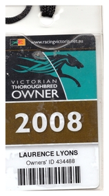
Ephemera - Victorian Thoroughbred Owner Passes for Victoria, 2008, 2011, 2012
Barry Lyons owned and managed the Windemere Hotel in Kangaroo Flat along with his wife Betty. Barry was a long time member of the Lions Club of Kangaroo Flat. Barry served as a Bendigo City Councillor from 2008 to 2016, and as Mayor in 2013 - 2014. Four passes collected and owned by Barry Lyons of Bendigo. Plastic passes attached to a lanyard.bendigo, barry and betty lyons, windemere hotel kangaroo flat, lions club kangaroo flat, victorian horse racing, victorian thoroughbred owners -
 Bendigo Historical Society Inc.
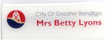
Ephemera - City of Greater Bendigo Councillor's Partner Badge, 2000-2020
Barry Lyons owned and managed the Windemere Hotel in Kangaroo Flat along with his wife Betty. Barry was a long time member of the Lions Club of Kangaroo Flat. Barry served as a Bendigo City Councillor from 2008 to 2016, and as Mayor in 2013 - 2014. Two identical name badges owned by Mrs Betty Lyons, with magnetic holder on the rear; collected and owned by Barry Lyons of Bendigo.bendigo, barry and betty lyons, windemere hotel kangaroo flat, lions club kangaroo flat, city of greater bendigo council -
 Bendigo Historical Society Inc.
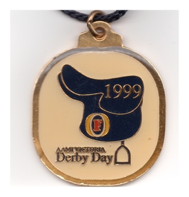
Ephemera - Cox Plate Medallion, 1999
Barry Lyons owned and managed the Windemere Hotel in Kangaroo Flat along with his wife Betty. Barry was a long time member of the Lions Club of Kangaroo Flat. Barry served as a Bendigo City Councillor from 2008 to 2016, and as Mayor in 2013 - 2014. Commemorative medallion for the AAMI Derby Day, collected and owned by Barry Lyons of Bendigo, with Fosters logo on saddle.bendigo, barry and betty lyons, windemere hotel kangaroo flat, lions club kangaroo flat, aami derby day, horse racing -
 Bendigo Historical Society Inc.
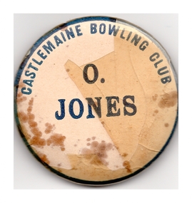
Ephemera - Castlemaine Bowling Club Badge, 1950-60s
Barry Lyons owned and managed the Windemere Hotel in Kangaroo Flat along with his wife Betty. Barry was a long time member of the Lions Club of Kangaroo Flat. Barry served as a Bendigo City Councillor from 2008 to 2016, and as Mayor in 2013 - 2014. Name bade for "O. Jones" Collected and owned by Barry Lyons of Bendigo. Pin attachment.bendigo, barry and betty lyons, windemere hotel kangaroo flat, lions club kangaroo flat, castlemaine bowling club -
 Bendigo Historical Society Inc.
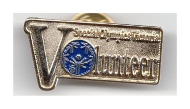
Ephemera - Special Olympics Victoria Volunteer Pin/Badge, Abt 2010
Barry Lyons owned and managed the Windemere Hotel in Kangaroo Flat along with his wife Betty. Barry was a long time member of the Lions Club of Kangaroo Flat. Barry served as a Bendigo City Councillor from 2008 to 2016, and as Mayor in 2013 - 2014. Collected and owned by Barry Lyons of Bendigo. Clutch pin attachment.bendigo, barry and betty lyons, windemere hotel kangaroo flat, lions club kangaroo flat, special olympics melbourne -
 Bendigo Historical Society Inc.
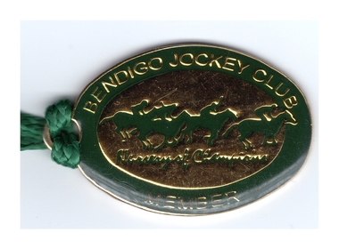
Ephemera - Bendigo Jockey Club Member Badge, 1998/99
Barry Lyons owned and managed the Windemere Hotel in Kangaroo Flat along with his wife Betty. Barry was a long time member of the Lions Club of Kangaroo Flat. Barry served as a Bendigo City Councillor from 2008 to 2016, and as Mayor in 2013 - 2014. One member medallion collected and owned by Barry Lyons of Bendigo.bendigo, barry and betty lyons, windemere hotel kangaroo flat, lions club kangaroo flat -
 Bendigo Historical Society Inc.
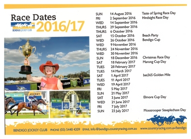
Ephemera - Bendigo Jockey Club Passes and Magnetic Calendar, Lyons Collection, 2011-2017
Barry Lyons owned and managed the Windemere Hotel in Kangaroo Flat along with his wife Betty. Barry was a long time member of the Lions Club of Kangaroo Flat. Barry served as a Bendigo City Councillor from 2008 to 2016, and as Mayor in 2013 - 2014. Seven Passes and a calendar collected and owned by Barry Lyons of Bendigo.bendigo, barry and betty lyons, windemere hotel kangaroo flat, horse racing, bendigo jockey club -
 Bendigo Historical Society Inc.
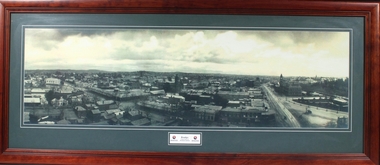
Photograph - Framed Photograph of Bendigo, Lyons Collection, 2011-2017
Barry Lyons owned and managed the Windemere Hotel in Kangaroo Flat along with his wife Betty. Barry was a long time member of the Lions Club of Kangaroo Flat. Barry served as a Bendigo City Councillor from 2008 to 2016, and as Mayor in 2013 - 2014. Framed copy of a black and white photograph of Bendigo taken from the tower at the mechanics Institute 1906 Showing Pall Mall, Law Courts, Post Office, Town Hall, circa 1906. Behind glass with a grey mount and dark brown wooden frame. An inserted in the mount under photo has two City of Greater Bendigo logos and printed between them - Bendigo from Tower of Mechanics Insitute. The photograph was presented to Barry Lyons when he was the Mayor of The City of Greater Bendigo.bendigo, barry and betty lyons, windemere hotel kangaroo flat, horse racing, bendigo jockey club -
 Greensborough Historical Society
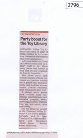
Newspaper Clipping, Diamond Valley Leader, Party boost for the Toy Library, 13/01/2016
Diamond Valley Toy Library added an array of extra items to its inventory following a Telstra Kids Fund Grant. Three new party packs and dozens of toys were purchased.News clipping, black text.diamond valley toy library, telstra kids fund -
 Greensborough Historical Society
Newspaper Clipping, Cinema hosts sensory movie, 13/01/2016
Banyule Council and Hoyts Greensborough developed a sensory-friendly screening of Star Wars VII: The Force Awakens, for children on the Autism Spectrum.News clipping, black text.hoyts greensborough, banyule city council, autism -
 Greensborough Historical Society
Newspaper Clipping, Diamond Valley Leader, Champ has hoop dreams, 13/01/2016
Montmorency student Liam Doherty won gold in shot put at a School Sports Australia event in Canberra in December 2015. Pickett plans to pursue a career as a professional basketballer in the future.News clipping, black text, colour image.school sports australia, diamond valley basketball association, liam doherty -
 Greensborough Historical Society
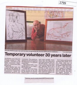
Newspaper Clipping, Temporary volunteer 30 years later, 13/01/2016
Watsonia artist Marcello D'Amico's volunteer work was recognised with an award from the Victorian Multiculturalism Commission. D'Amico has been a volunteer for the Italian Pensioners Federation of Victoria, and affiliated social clubs for the last 30 years.News clipping, black text, colour image.watsonia artist, marcello damico, victorian multiculturalism commission award -
![Newspaper Clipping, Diamond Valley Leader, Pride of the nation [Australia Day Awards], 27/01/2016](/media/collectors/4f729f5697f83e03086015b8/items/57d280cad0cdd11f0cf45ae4/item-media/57d28128d0cdd11f0cf48e4f/item-fit-380x285.jpg) Greensborough Historical Society
Greensborough Historical SocietyNewspaper Clipping, Diamond Valley Leader, Pride of the nation [Australia Day Awards], 27/01/2016
Beverley Brock received a Medal of the Order of Australia for 25+ years of contributions to the community. Ms Brock received the award for helping young people and families overcome emotional, health, educational, financial and family hurdles. Jennifer Loughman received a Medal of the Order of Australia for her contributions to people with cystic fibrosis and their families.News clipping, black text, colour image.australia day awards, beverley brock, jennifer loughman -
 Greensborough Historical Society
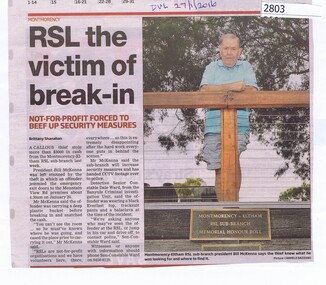
Newspaper Clipping, Diamond Valley Leader, RSL victim of break-in, 27/01/2016
A thief broke into Montmorency Eltham RSL and stole $3000 in cash. The RSL will now improve security measures.News clipping, black text, colour image.montmorency eltham rsl, bill mckenna -
 Greensborough Historical Society
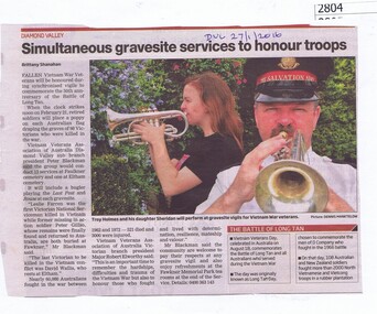
Newspaper Clipping, Diamond Valley Leader, Simultaneous gravesite services to honour troops, 27/01/2016
Fallen Vietnam War Veterans to be honoured in vigils to commemorate the 50th anniversary of the battle of Long Tan in August.News clipping, black text, colour image.vietnam war, battle of long tan -
![Newspaper Clipping, Diamond Valley Leader, Trio excited for big day [AP5184], 27/01/2016](/media/collectors/4f729f5697f83e03086015b8/items/57d28645d0cdd11f0cf71878/item-media/57d28670d0cdd11f0cf73430/item-fit-380x285.jpg) Greensborough Historical Society
Greensborough Historical SocietyNewspaper Clipping, Diamond Valley Leader, Trio excited for big day [AP5184], 27/01/2016
Greensborough triplets Peter, Christina and Zoe Zougras to start school at Apollo Parkways Primary School in Greensborough.News clipping, black text, colour image.apollo parkways primary school, diamond valley multiple birth association, zougras family -
 Greensborough Historical Society
Newspaper Clipping, Diamond Valley Leader, Forced rates capping to shoot $12.5m hole in council budget, 20/01/2016
Banyule Council faces a $12.5 million black hole in its budget due to rates capping and says it is too early to know what services will be slashed.News clipping, black text.banyule city council, council rates -
 Greensborough Historical Society
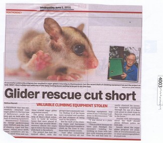
Newspaper Clipping, Diamond Valley Leader, Glider rescue cut short, 01/06/2016
A community program resulted in sugar gliders returning to Montmorency, but a recent theft of climbing equipment has halted the program.News clipping, black text, colour image. montmorency, sugar gliders, alan cuthbertson -
 Greensborough Historical Society
Newspaper Clipping, Diamond Valley Leader, Banking simplified, 01/06/2016
The refurbished Westpac branch in Main Street Greensborough offers 24-hour banking with high-tech features.News clipping, black text. main street greensborough, westpac bank -
 Greensborough Historical Society
Newspaper Clipping, Diamond Valley Leader, Shop keeps charm in move, 01/06/2016
Scissorman's Men's Hairdressing moved to 4 Hailes Street East and is now called John's Barber Shop.News clipping, black text, colour image. hailes street greensborough, scissormans, johns barber shop, john goral -
 Ballarat Heritage Services
Photograph - Colour, Earth Banks, Old Sarum, England, 01 November 2016
William the Conqueror inherited Old Sarum from the last Saxon king of England. It was an ideal site for a royal castle. It was here in 1070 that William paid off his army after a long and bitter campaign in northern England. It was here in 1086 that he called together all the major landholders in England so they could swear allegiance to him. It was a crucial moment. The Domesday Book was being written, a threatened Viking invasion had only just been averted and William's eldest son was in armed rebellion. Old Sarum was an important place where this Norman king of England held power. In 1794 the Ordnance Survey set out to check the accuracy of the first mapping of Southern England, which had begun ten years earlier. From a point just below Old Sarum Lieutenant William Mudge laid out a base-line 36,574 feet (11,253 metres) long. From each end of the line the positions of distant places were plotted using a huge theodolite made in 1791 by Jesse Ramsden. The accuracy of the process, which was repeated all over England, depended on Jesse Ramsden's craftsmanship and on William Mudge's surveying skill in setting out this first base-line from Old Sarum. The nearer end of Mudge's line is marked by an inscribed stone beside the modern A345 at Old Sarum. ordnance survey, william mudge, jesse ramsden, william the conqueror, old sarum, saxon, 1086, england -
 Ballarat Heritage Services
Photograph - Colour, Stonework, Old Sarum, England, English Heritage Site, 01 November 2016
William the Conqueror inherited Old Sarum from the last Saxon king of England. It was an ideal site for a royal castle. It was here in 1070 that William paid off his army after a long and bitter campaign in northern England. It was here in 1086 that he called together all the major landholders in England so they could swear allegiance to him. It was a crucial moment. The Domesday Book was being written, a threatened Viking invasion had only just been averted and William's eldest son was in armed rebellion. Old Sarum was an important place where this Norman king of England held power. In 1794 the Ordnance Survey set out to check the accuracy of the first mapping of Southern England, which had begun ten years earlier. From a point just below Old Sarum Lieutenant William Mudge laid out a base-line 36,574 feet (11,253 metres) long. From each end of the line the positions of distant places were plotted using a huge theodolite made in 1791 by Jesse Ramsden. The accuracy of the process, which was repeated all over England, depended on Jesse Ramsden's craftsmanship and on William Mudge's surveying skill in setting out this first base-line from Old Sarum. The nearer end of Mudge's line is marked by an inscribed stone beside the modern A345 at Old Sarum. ordnance survey, william mudge, jesse ramsden, william the conqueror, old sarum, saxon, 1086, england -
 Ballarat Heritage Services
Photograph - Colour, Sign Explaining toilets, Old Sarum, England, English Heritage Site, 01/11/2016
William the Conqueror inherited Old Sarum from the last Saxon king of England. It was an ideal site for a royal castle. It was here in 1070 that William paid off his army after a long and bitter campaign in northern England. It was here in 1086 that he called together all the major landholders in England so they could swear allegiance to him. It was a crucial moment. The Domesday Book was being written, a threatened Viking invasion had only just been averted and William's eldest son was in armed rebellion. Old Sarum was an important place where this Norman king of England held power. In 1794 the Ordnance Survey set out to check the accuracy of the first mapping of Southern England, which had begun ten years earlier. From a point just below Old Sarum Lieutenant William Mudge laid out a base-line 36,574 feet (11,253 metres) long. From each end of the line the positions of distant places were plotted using a huge theodolite made in 1791 by Jesse Ramsden. The accuracy of the process, which was repeated all over England, depended on Jesse Ramsden's craftsmanship and on William Mudge's surveying skill in setting out this first base-line from Old Sarum. The nearer end of Mudge's line is marked by an inscribed stone beside the modern A345 at Old Sarum. Colour photograph of a sign explaining toilets at Old Sarum, English Heritage Siteordnance survey, william mudge, jesse ramsden, william the conqueror, old sarum, saxon, 1086,, england -
 Ballarat Heritage Services
Photograph - Colour, Old Sarum, England, 2017, 01 November 2016
William the Conqueror inherited Old Sarum from the last Saxon king of England. It was an ideal site for a royal castle. It was here in 1070 that William paid off his army after a long and bitter campaign in northern England. It was here in 1086 that he called together all the major landholders in England so they could swear allegiance to him. It was a crucial moment. The Domesday Book was being written, a threatened Viking invasion had only just been averted and William's eldest son was in armed rebellion. Old Sarum was an important place where this Norman king of England held power. In 1794 the Ordnance Survey set out to check the accuracy of the first mapping of Southern England, which had begun ten years earlier. From a point just below Old Sarum Lieutenant William Mudge laid out a base-line 36,574 feet (11,253 metres) long. From each end of the line the positions of distant places were plotted using a huge theodolite made in 1791 by Jesse Ramsden. The accuracy of the process, which was repeated all over England, depended on Jesse Ramsden's craftsmanship and on William Mudge's surveying skill in setting out this first base-line from Old Sarum. The nearer end of Mudge's line is marked by an inscribed stone beside the modern A345 at Old Sarum. ordnance survey, william mudge, jesse ramsden, william the conqueror, old sarum, saxon, 1086, england -
 Ballarat Heritage Services
Photograph - Colour, Earth Banks, Old Sarum, England, 01 November 2016
William the Conqueror inherited Old Sarum from the last Saxon king of England. It was an ideal site for a royal castle. It was here in 1070 that William paid off his army after a long and bitter campaign in northern England. It was here in 1086 that he called together all the major landholders in England so they could swear allegiance to him. It was a crucial moment. The Domesday Book was being written, a threatened Viking invasion had only just been averted and William's eldest son was in armed rebellion. Old Sarum was an important place where this Norman king of England held power. In 1794 the Ordnance Survey set out to check the accuracy of the first mapping of Southern England, which had begun ten years earlier. From a point just below Old Sarum Lieutenant William Mudge laid out a base-line 36,574 feet (11,253 metres) long. From each end of the line the positions of distant places were plotted using a huge theodolite made in 1791 by Jesse Ramsden. The accuracy of the process, which was repeated all over England, depended on Jesse Ramsden's craftsmanship and on William Mudge's surveying skill in setting out this first base-line from Old Sarum. The nearer end of Mudge's line is marked by an inscribed stone beside the modern A345 at Old Sarum. ordnance survey, william mudge, jesse ramsden, william the conqueror, old sarum, saxon, 1086, england