Showing 3212 items
matching road maps
-
 Bacchus Marsh & District Historical Society
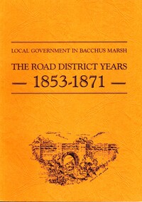
Book, John Lloyd, The Road District Years, 1853-1871: Local Government in Bacchus Marsh
This work describes the early evolution and history of local government in the Bacchus Marsh area. Local government bodies in Victoria and in other places had their origins in committees and local boards which were established to regulate over pressing local issues, raise revenue, and expend it in a limited range of social and economic ways. The early areas of responsibility were dominated by the need for local roads and this book primarily looks at this period of local government history in the Bacchus Marsh area. Overtime the range of areas local government bodies took responsibility for expanded and this work begins to trace this transformation in its earliest stages. It is a fascinating and detailed account of the early history of local government in Bacchus Marsh containing many amusing anecdotes among the wealth of administrative historical data. The author who was at one time an employee of the Shire of Bacchus Marsh has drawn directly from the early local records such as minutes of meetings, records of expenditure, newspaper reports and notices in the Victoria Government Gazette.Soft cover foolscap size book. 128 pages with b & w illustrations, maps and plans. No publisher is indicated in the work but it is likely to have been privately published by the author John Lloyd. Year and place of publication is 1986, Bacchus Marsh, Victoria.non-fictionThis work describes the early evolution and history of local government in the Bacchus Marsh area. Local government bodies in Victoria and in other places had their origins in committees and local boards which were established to regulate over pressing local issues, raise revenue, and expend it in a limited range of social and economic ways. The early areas of responsibility were dominated by the need for local roads and this book primarily looks at this period of local government history in the Bacchus Marsh area. Overtime the range of areas local government bodies took responsibility for expanded and this work begins to trace this transformation in its earliest stages. It is a fascinating and detailed account of the early history of local government in Bacchus Marsh containing many amusing anecdotes among the wealth of administrative historical data. The author who was at one time an employee of the Shire of Bacchus Marsh has drawn directly from the early local records such as minutes of meetings, records of expenditure, newspaper reports and notices in the Victoria Government Gazette.bacchus marsh shire council, local government bacchus marsh history -
 Friends of St Brigids Association
The Irish Australians : selected articles for Australian and Irish family historians, The Irish Australians : selected articles for Australian and Irish family historians / edited by Richard Reid and Keith Johnson .1984. Sydney : Society of Australian Genealogists, 1984 56 p. : ill., facsims., map, ports. ; 30 cm
-
Friends of St Brigids Association
Leatherwood honey for Gall : A convict marries an immigrant Girl, Reddrop, Mary. 2000. Leatherwood Honey for Gall : A Convict Marries an Immigrant Girl. Blackburn, Vic. : PenFolk Publishing, 2000 viii, 210 p. : ill. (some col.), facsim., maps, ports.; 21 cm
-
Friends of St Brigids Association
Book - Letters from Irish Australia 1825-1929, O’Farrell, Patrick James. 1984. Letters from Irish Australia 1825-1929. Sydney : New South Wales University Press ; Belfast : Ulster Historical Foundation, 1984 244 p. : ill., maps ; 25 cm
-
Friends of St Brigids Association
Book - Melbourne and the Irish Famine: The unveiling of a new monument, Noone, Val. 1998. Melbourne and the Irish Famine: The unveiling of a new monument. Melbourne : Irish Famine Commemoration Committee, 1998 22 p. : ill., map ; 21 cm
-
Friends of St Brigids Association
Book - Croppies, Celts, and Catholics : The Irish in Australia, McConville, Chris. 1987. Croppies, Celts, and Catholics : The Irish in Australia. Caulfield East, Vic. : Edward Arnold, 1987 167 p. : ill., maps, ports. ; 25 cm
-
Friends of St Brigids Association
Book - A Shamrock beneath the Southern Cross : An History of the Shire of Belfast, Marriott, Pamela M. 1988. A Shamrock beneath the Southern Cross : An History of the Shire of Belfast.[Warrnambool, Vic.] : P. Marriott, 1988 184 p. : ill., maps, ports. ; 22 cm
-
Friends of St Brigids Association
Book - Saving St Brigid’s, Lane, Regina. 2014. Saving St Brigid’s. Carlton South, Victoria : Bridin Books, 2014 .242 pages, 16 unnumbered pages of plates : illustrations (some colour), maps, portraits ; 24 cm
-
Friends of St Brigids Association
Book - An Atlas of Irish History, Edwards, Ruth Dudley. 1989. An Atlas of Irish History. London ; New York : Methuen, 1981 1 atlas (286 p.) : maps ; 24 cm
-
 Mont De Lancey
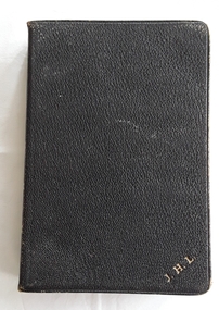
Book, Oxford University Press, 1. The Holy Bible, containing the Old and New Testaments 2. Daily Light on the Daily Path, Unknown
1. A Holy Bible containing the Old and New Testaments. At the back there is an Indexed Atlas to the Holy Bible with a List of maps and a List of Biblical Names. This is followed by twelve yellow and blue coloured maps of the Lands and Nations of the Bible. 2.A miniature book titled Daily Light on the Daily Path, A Devotional text book for everyday in the year..1. A black leatherette softcover Holy Bible contains the Old and New Testaments with the title and publisher Oxford printed in gold lettering on the spine. There are five embossed double lines on the spine too. On the front cover at the bottom right there is printed in gold lettering J.H.L. At the back there is an Indexed Atlas to the Holy Bible with a List of maps and a List of Biblical Names. This is followed by twelve yellow and blue coloured maps of the Lands and Nations of the Bible. The pages have gilt edges. 348p. Inside the front right hand side endpaper written in small blue handwriting is a prayer as written in the Inscription box below. 2. A miniature brown leatherette softcover book titled Daily light on the Daily Path - a devotional text book for every day of the year. The faded title is printed on the front cover at the top and on the spine. At the back there is a section For Special Occasions: Easter, Affliction, Marriage, Bereavement and others. There are two lists of the Daily Texts - the morning and evening hour arranged in biblical order. The edges of the pages are gilt. In the front is handwriiten in black ink - Neville Lordnon-fiction1. A Holy Bible containing the Old and New Testaments. At the back there is an Indexed Atlas to the Holy Bible with a List of maps and a List of Biblical Names. This is followed by twelve yellow and blue coloured maps of the Lands and Nations of the Bible. 2.A miniature book titled Daily Light on the Daily Path, A Devotional text book for everyday in the year..religious books, bibles, prayers -
 Mont De Lancey
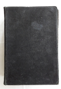
Book - The Holy Bible - The Revised Version, Oxford University Press, 1949
A Holy Bible containing the Old and New Testaments with six coloured biblical maps at the back.A black hardcover Holy Bible, Revised Version, Oxford printed in gold lettering on the spine with five raised black lines across. The pages have worn gilt edges and there is a self bookmark included. 286p. It contains the Old and New Testament. At the back there are six coloured maps of the biblical locations. The title page has a glued in black and white photograph of Mr and Mrs J.H. Lord standing a garden. There is a small card attached with photo hinges with the inscription below. Mr and Mrs J.H. Lord is written by hand in black ink below the photograph. The back cover is mended with a wide strip of white cotton material.non-fictionA Holy Bible containing the Old and New Testaments with six coloured biblical maps at the back.religious books, bibles -
 Mont De Lancey
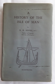
Book, R.H. Kinvig, M.A, A History of the Isle of Man, 1950
The author, Professor of Geography at the University of Birmingham R.H. Kinvid, M.A. published this new edition of the history of The Isle of Man in 1950, six years after the first edition, to include fresh discoveries that have been made, particularly in the archaeological field, and of the important political developments that have taken place in recent years. Some changes have also been made in the maps and other illustrations.A navy blue hardcover book with a grey dust jacket covered in library style plastic sleeving.The title: A History of the Isle of man is printed in black lettering at the top of the front cover with the author, R.H. Kinvig, M.A. underneath. A black outline of an ancient vessel is illustrated too. On the spine is written the title, author and 7s 6p. Throughout the book there are black and white photographs and illustrations. On the back cover is a circle with three legs wearing trousers and boots with the words: ICERIS STABIT QUOCUNIQUE around the edges of the legs inside the circle. Pp. 180 non-fictionThe author, Professor of Geography at the University of Birmingham R.H. Kinvid, M.A. published this new edition of the history of The Isle of Man in 1950, six years after the first edition, to include fresh discoveries that have been made, particularly in the archaeological field, and of the important political developments that have taken place in recent years. Some changes have also been made in the maps and other illustrations.history, isle of man, ancient history -
 Mont De Lancey
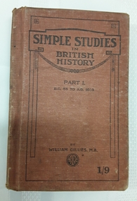
Book, William Gillies, M.A, Simple Studies in British History Part 1, 1920
A simple study in British History for secondary school students with a fold out map of the British Empire at the time - published in 1920. There is a list of the dynasties and kings and queens and a table of Periods in British History which can be referred to.A small tan cloth covered hardcover book with the title: Simple Studies in British History Part 1 B.C. 55 to A.D. 1603 printed in black lettering on the front cover with the publisher, a round publisher symbol and 1/9 at the bottom. The title is printed on the spine. This is a Second Course of Reading in British History by William Gillies, M.A. Inside, opposite the title page, is a foldout map of the British Empire throughout the world, showing the empire in red. Black and white illustrations and photographs are included. At the back is included three other history titles. It is quite damaged and worn through use. Pp.168.non-fictionA simple study in British History for secondary school students with a fold out map of the British Empire at the time - published in 1920. There is a list of the dynasties and kings and queens and a table of Periods in British History which can be referred to.great britain - history, history, textbooks -
 Mont De Lancey
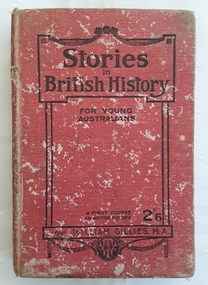
Book, William Gillies, M.A, Stories in British History for Young Australians, 1920
A simple study in British History for secondary school students with a fold out map of the British Empire at the time - published in 1920. There is a list of the dynasties and kings and queens and a table of Periods in British History which can be referred to.A badly damaged red cloth covered hardcover book with the title: Stories in British History for Young Australians printed in black lettering on the front cover with the publisher, a round publisher symbol and 2/6 at the bottom. The title is printed on the spine. This is a First Course in British History by William Gillies, M.A. Inside, opposite the title page, is a lined sketch of Oliver Cromwell. Black white illustrations, maps and photographs are included. At the back is an Index as well as three additional recommended titles of other history books. Considerable markings, lists and a love poem is scribbled at the back. It is quite damaged and worn through use. Pp.315.non-fictionA simple study in British History for secondary school students with a fold out map of the British Empire at the time - published in 1920. There is a list of the dynasties and kings and queens and a table of Periods in British History which can be referred to.great britain - history, history, textbooks -
 Wonga Park Community Cottage History Group
Photograph (sub-item) - Map of original land settlement in 1890’s – known as ‘the Eight Hour Pioneer village Settlememt’, the square mile around the Wonga Park Store today (red square)
... Old Yarra Road Wonga Park melbourne Map of original land ...Map of original land settlement in 1890’s – known as ‘the Eight Hour Pioneer village Settlememt’, the square mile around the Wonga Park Store today (red square). -
 Melton City Libraries
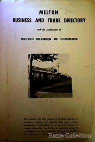
Booklet, Melton Business and Trade Directory, c.1965
BUSINESS TRADE AND DIRECTORY MAP NORTH of High Street RALIEGHS Road - Early settlers Oliver Reierson ( Norwegian) Raliegh SHEBLER Court Auguste EMIL Court Jongebloed Family residence “Hemlich” ALEXANDRA Street Coronation King, Queen Alexandra - 1903 O’NEILS Road Farmer OLDERSHAW Road CORR Grove Early landowner, Teacher at the Common School – Denominational Churches, 1850’s Wesleyan (Methodist) BRYAN Court 1850’s resident renamed from earliest town site - Flat HURLEY Street Early settler and farmers - CHESNEY Road was named Minns, due to duplication altered to Chesney (Minns) SOUTH of High ALKEMADE Drive. Family name ARNOLD Court Family BARRIES Road Charles Ernest Barrie “Darlingsford” 1911 Residence KILPATRICKS Road became Barries Road west of Station Road BLACKWOOD Drive Alexander, Early settler CALLANAN Drive Surveyor early LUBY Court John Luby - Crown Grant Land title KERWIN Street Michael - Crown Grant land title (deleted due to Freeway)Pamphlet of Melton Businesses and map of the townlocal identities, misc., council -
 Melton City Libraries
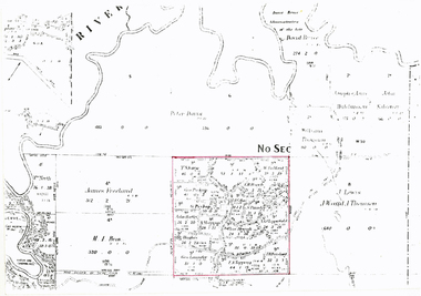
Document, Minns Family Reunion, 2004
"A perpetual spring in the adjacent creek provided a steady supply of fresh water to the site on which the homestead is built. Although we can not be certain of the identity of the builder, the first stage of ‘The Willows’ homestead appears to have been constructed in the mid 1850s. The house is situated on Crown Allotment No.1 (No Section), Parish of Kororoit, an allotment of 5 acres 3 roods 4 perches. Although it had surveyed the land, the Crown did not offer it for sale until 22nd November 1861, at which time it was purchased by Charles March Williams. (Although the property is directly opposite and immediately adjacent to the Township of Melton, and was sold as ‘Suburban Allotment 33’, it was situated within the Shire of Braybrook rather than the Shire of Melton until 1917.) Considerable improvements had taken place on the land prior to the Crown sale. When CM Williams purchased the allotment in November 1861 he paid £23.5.0 for the land itself, and valued the improvements at £400. Even allowing for some exaggeration by Williams, this is an extremely high valuation for improvements, and must have included a house. Some local research has claimed that in 1858 Williams had taken over the interest of a Mr Parkinson in the property, and that Parkinson built the house upon taking possession of the land c.1855. It was definitely built by 1861, when a map shows a square building on the site marked as ‘House’. The property is important in the district for its association with the establishment of the pound. The district pound had been established in 1854, when George Scarborough of Mount Cottrell (Mt Cottrell Road, south of Greigs Road) was appointed pound-keeper. Scarborough resigned in 1857. The pound was moved to Melton following agitation from local farmers and Charles March Williams appointed pound-keeper on 26th April 1858. Williams, the son of a doctor, had been born in London. Reminiscences of local residents of the time, as recorded in the Express newspaper, note Williams’ success in breeding horses on the property. Sales of up to 60 guineas were noted. Whether this was from Williams’s own stock or from unclaimed pound stock is not made clear. Williams appeared before a government inquiry in 1860 and advocated registration of all stock brands in the State. Williams died in 1862 leaving a widow, Catherine, and five living children aged 15 years to five months. At the time of his death Williams had entered negotiations with one Matthew Devenish and had a mortgage of £100 on allotments 1 and 2, Parish of Kororoit. Catherine Williams was appointed pound-keeper on 2 September 1863, with her eldest son Charles as her assistant. Her tenure was short for on 22nd March 1864 George Minns senior paid Matthew Devenish £135 for allotments 1 and 2 Parish of Kororoit (considerably less than Williams had claimed the property was worth in 1861) and on the same day paid William Tullidge £45 for the adjoining allotments 3 and 4. In April 1867, James Ebden Minns, the newly married son of George senior became the owner of The Willows property having entered into a mortgage arrangement with his father to the extent of £200. At the time George Minns was residing in Kaarimba having left Melton in 1867 for a short trip to England and upon his return having taken up a selection in the Kaarimba district with his son Frederick who had a hotel licence there. James paid out the mortgage on 2-1-1873. James Minns was appointed pound-keeper in 1872; in 1885 the pound was moved elsewhere and Minns purchased the old pound site and added it to his farm. The Willows residence underwent a major change about this time. A two room extension, similar in style but with a lower elevation was added to the original rear of the house with a chimney matching the distinctive originals. Window arrangements did not match the original but became a feature of the façade when the new addition became the front of the building. Six buttresses were attached to the east and west walls of the old building, two to the south wall and the whole rendered with mortar to give the appearance of dressed stonework around the windows. Galvanized iron was placed over the shingles and a verandah added on three sides. By 1876 The Willows was the homestead for a thriving mixed farm of 340 acres of which 156 was rented from a H. Ruck. In October of that year the Australasian travelling reporter visited and reported on the property. In common with the nearly every other property in the district the farm had ‘recently’ (generally within the last two years) abandoned cultivation of crops, and turned over completely to cattle pasture. Butter making was the principal occupation of the farm, which had about 50 head of cattle, a large proportion of which were milking cows. The reporter also noted that a ‘large number of pigs are kept upon this farm and are found to be very profitable stock’. Their manure was used in an orchard and garden in which ‘large quantities of lucerne and prairie grass are grown for the use of stock when ordinary feed is scarce’. Two bores attached to deep brick lined wells supplied water for the house in addition to the farm. A commodious timber barn and necessary sheds had also been constructed. Access to the property was improved following the construction of the bluestone ford across the creek c.1887, when the recreation ground came into use. Prior to this date it may have been that the crossing referred to as ‘Mr Minns bridge’ was used. This appears to have been a flimsy structure and has but two references in Council reports in the Melton Express in the 1880’s. It is believed that in the late 1890’s a timber building was added near the rear of the building to house a kitchen, ablutions and laundry rooms and rooms for seasonal workers. This was attached to the house by means of a trellised walkway using the original front entry to the house (long since the back door). A photograph of this building appears in a local history of Melton. This was demolished in recent decades during the period when the house was tenanted (after the Minns family had left). James Minns son, George, took over the property following his marriage to Alice Walsh in 1903. James and Caroline moved into a house on the former JH Games property at the eastern end of Henry Street. George held the position of Shire Secretary for Melton for 40 years. He was a most prominent member of the community being Secretary to, among others, the Melton Coursing Club, the Shooting Club and the Cemetery Trust. He also rode with the hunting parties who sported across the Plains and were entertained at Mount Kororoit. George and Alice had one son, Norman who followed his father into local government and became Secretary of the Shire of Werribee completing a record term in this position. George retired to Werribee in 1951, where he died in 1965. The National Trust records note that James Ebden Minns and his sons were ‘leading men of the district, Justices of the Peace, and Shire Councillors’. It claims that Sir Thomas Bent was a frequent visitor. The Willows passed into the hands of George’s grandson, Bruce Minns and the property was let for a number of years. In the 1960s it became vacant and was subject to vandalism. Major structural problems arose with the part demolition of the roof, the loss of windows and doors and holes dug into and under the floorboards. The outbuildings were particularly targeted. Following widespread public support, the Shire of Melton purchased the house, with 3.75 acres of land, in 1972. In 1975 the Shire of Melton and the Melton and District Historical Society were successful in nominating the building for National Trust classification, and then the Australian Heritage Commission’s Register of the National Estate. The AHC particularly noted its ‘townscape importance’. It was envisaged that the farmhouse would form ‘a picturesque centrepiece to Melton’s planned … historical park, along with Dunvegan bluestone cottage … and similar structures as they become available.’ In a time of great Melton’s ‘satellite city’ development the Council spelt out its broader vision in its submission to the AHC: ‘Melton is destined to become, by the end of the present century, a city of between 75,000 and 100,000 people. Significant relics of the past, such as ‘The Willows’, regrettably will be rare in that situation. It is essential that sufficient tangible links with Melton’s pioneering days remain to promote in the new community a sense of history and continuity’. Under the direction of ‘The Willows’ Restoration Committee and consultant architect John Hitch, all outbuildings, with the exception of the garage and toilet, were demolished and the dwelling house restored. Finances were provided by the Shire of Melton and the National Estate Grants Program, and considerable amount of voluntary labour was provided by the local community. The orchard was removed, and remaining wooden buildings were relocated to provide an open vista for visitors to the Park. The property was furnished with donations from district families keen to preserve this example of pioneer life in the area. The Willows became the headquarters of the Melton and District Historical Society". Invitation to the family reunion at the Willowslocal identities, pioneer families -
Canterbury History Group
Pamphlet - A Golding Walk in Canterbury, Da Costa-Adams, Robin, 2006
Brochure prepared by Robin Da Costa- Adams for the walk she led on behalf of the Canterbury History Group, 2006. Includes illustrations, photographs and a map of the sites covered.canterbury, balwyn road, mont albert road, canterbury road, rochester road, john august reserve, balwyn wesleyan/methodist church, "the pines", golding family, tibbets> william, churches, factories, halls -
Canterbury History Group
Document - Canterbury Mansions and Stables, 13/03/1991 12:00:00 AM
Photocopy of a document relating to the Draft Statement of Significance for Canterbury Mansions. Contains a short history of Canterbury, the role the hotel has played in that history, and descriptions of the interior and exterior. Includes many photographs and 2 mapscanterbury, canterbury mansions, canterbury club hotel, canterbury road, city of boroondara, historic buildings register, jacob lewis vines, malone family, temperance movement, wattle valley road, stables, outbuildings -
Canterbury History Group
Map - Elgar's Special Survey, copied 1989
Map of "Elgar's Special Survey" 8 square miles chosen by Henry Elgar in 1841, showing the location of J.B.Maling's Paddock and house, 13 acres bought in 1864.camberwell, balwyn, deepdene, canterbury, surrey hills, elgar's special survey, land subdivision, maps, maling family -
 Mont De Lancey
Book, A. H. Massina & Co, A.H. Massina and Co's Weather Almanac and General Guide and Handbook for Victoria for 1894, 1901
A plain red hardcover book - Weather Almanac and General Guide and Handbook for Victoria 1894. A.H.M. & Co's Almanac 1894 - 01. There are maps, calendars, diagrams and general information throughout the book for the guidance of village settlers.A red hardcover Weather Almanac and general Guide and Handbook for Victoria for 1894 - 01 with Calendar and Map of Railway Systems. It has advertisements, tables, calendars, maps, memoranda tables, diagrams and other notes of general interest throughout. non-fictionA plain red hardcover book - Weather Almanac and General Guide and Handbook for Victoria 1894. A.H.M. & Co's Almanac 1894 - 01. There are maps, calendars, diagrams and general information throughout the book for the guidance of village settlers.almanacs, documents, calendars -
 Mont De Lancey
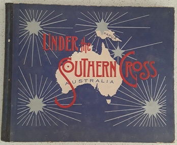
Book, William Applegate Gullick, Under the Southern Cross Australia, 1911
A non fiction book showing full page black and white photograph glimpses of the six states and one territory of Australia in 1910. The ACT is not shown as it was not a territory until 1911. There is simple text describing each photograph at the top and bottom of each page.A blue covered rectangular hardcover book titled in red text and black text on the front cover - Under the Southern Cross with a white map of Australia and Papua with five grey stars of varying sizes with lined rays around each one. Inside on the title page is printed, Glimpses of Australia - Issued under the the direction of the GOVERNMENT OF THE COMMONWEALTH OF AUSTRALIA. Department of External Affairs, Melbourne 1910. On the back of the title page is printed Sydney: William Applegate Gullick, Government Printer for the state of New South Wales. 1911 above an ornate lined symbol. Opposite the title page is a detailed map of Australia showing six states, the Northern Territory but not the ACT which didn't become a territory until 1911. The ACT (Self-Government) Act 1988 established the framework for the ACT Self-government.non-fictionA non fiction book showing full page black and white photograph glimpses of the six states and one territory of Australia in 1910. The ACT is not shown as it was not a territory until 1911. There is simple text describing each photograph at the top and bottom of each page.australia, australian states, australian territory, australian life, australian cities -
 Tarnagulla History Archive
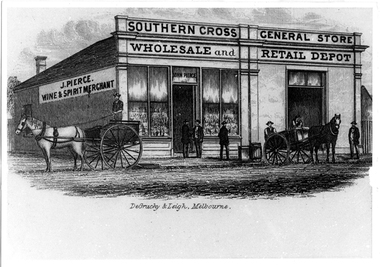
Photographic copy of lithograph: Pierce's Southern Cross Store, Tarnagulla, Pierce's Southern Cross Store, Tarnagulla, circa 1850 to 1871
Murray Comrie Collection. John Pierce's Southern Cross General Store, a wholesale grocer and spirit merchant was put up for sale after Pierce's death in 1871. It was later incorporated into the Flour Mill complex. De Gruchy & Leigh was a publishing and printing firm operating in Melbourne and regional Victoria from the late 1850s until the mid 1860s. The company published almanacs and guidebooks as well as prints (portraits, views and genre scenes), maps and architectural plans (Source: National Portrait Gallery, Canberra). This is a copy created from another item in the collection - a printed piece of paper which was either a packing label or receipt form used at the company or a brand label for bottles, perhaps for wine made by the proprietor. Copy probably made by Murray Comrie in the 1970s. Monochrome photographic copy of a lithograph. Depicts a building with glass front windows and signage stating 'J. Pierce Wine & Spirit Merchant' and 'Southern Cross General Store, Wholesale and Retail Depot'. In front of building on road are two horses hitched to carts and men standing on cart and in front of store. This store was located on the south-eastern corner of Commercial Road and King Street. The building was later incorporated into the flour mill complex.tarnagulla, commerce, shops, stores, shopping, food, alcohol, horses, transport, buildings, commercial road, main street, john pierce, southern cross general store -
 Melton City Libraries
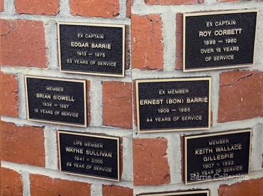
Photograph, Melton Fire Brigade Memorial Wall, 2013
Ernest W (Bon) Barrie, 1909 – 1985 Melton Fire Brigade (and predecessor Bush Fire Brigade) Apparatus Officer, 1945 - 1953 Captain, 1951 - 1965 Mt Cotterill Fire Brigades’ Group Elected Group Officer, on the formation of the Group, 1967. As Group Communications Officer he operated the VL3 LY base radio station from home on a 24 hour basis for fire brigades of Melton, Rockbank, Sydenham, Diggers Rest, Toolern Vale, Truganina and Werribee. With his brother Edgar, he built the first Melton Fire Truck. It was housed on the family property until a fire station was constructed in the Melton township. Recipient of the Queens Medal, 1979 Recognised for 44 years of service on the Melton Fire Brigade Memorial Wall Plaque, dedicated May 2013 Mt Cotterell Fire Brigades G H Q and aerial was erected at No 17 - 19 First Avenue in 1974 at the home of Edna and Bon Barrie. Previously the Mt Cotterell Group VL3LY communication headquarters occupied their h ome in Ferris road at its inception in 1967. The First Avenue headquarters and map room, with radio equipment was also housed at the residence. It was operated with an additional cable connection to Fireman Wayne Sullivan (Deputy C/O) who resided at the rear in Kurrajong Cr.Section of the Melton Fire Brigade Memorial wall with brigade members who have passed away while as members. emergency services, local identities -
 Mont De Lancey
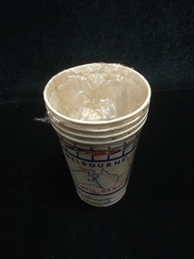
Paper Cup
Commemorating 1956 Melbourne Olympic GamesSet of four paper cups - white, red and blue with Athletes, flags and Australian map.cups, disposable cups -
Camberwell Historical Society
Booklet (Item), A History of 26 Prospect Hill Road, Camberwell, Victoria
camberwell -
Camberwell Historical Society
Document (Item), Gwen McWilliam, Along the High Street, again, 1994
camberwell, melbourne, high street -
 Camberwell Historical Society
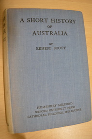
Book, Ernest Scott, A Short History of Australia, 1928
398 pages with illustrations and mapscamberwell, australia, history -
Camberwell Historical Society
Book - Photocopied pages from book, Bonwick, James, A Sketch of Boroondara, 1858
Photocopy of 11 pages, including a map, from James Bonwin's bookcamberwell, boroondara -
Camberwell Historical Society
Pamphlet (Item) - Map, Boroondara City of Harmony, Boroondara Leisure and Recreational Map, 1998
boroondara