Showing 31825 items
matching south
-
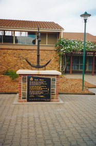 Mission to Seafarers Victoria
Photograph - Photograph, colour, c. 2001
Opened by His Excellency Sir Eric Neal AC CVO on 30 September 2001, the Memorial is located in City Park, Port Pirie, South Australia. The monument commemorates those who were lost at sea while serving with the Merchant Navy. Mr Noel Smith, a resident of Port Pirie, former Merchant Navy seaman and Port Pirie tugboat officer designed the memorial, found the anchor located on the top of the memorial during a dredging operation in a creek near the Nystar plant and wrote the poem inscribed on the main plaque. Front Inscription Lost Ones They live in the curl of the breaking wave, They sing when the sea winds blow, They lay not confined in a land locked grave, Nor in dim dark depths below. Do you hear them laugh in the rippling tide, Call free in the ocean breeze ? Do you see them soar where great gulls glide At peace with the fearsome seas ? They live still in the hearts of those who wait Held strong in the bonds of love 'Til their souls unite and congregate In God`s great harbour above. Noel Smith Merchant Seaman For those who were lost to the depths of the sea Emma Hindmarsh Left Side Inscription Memorial unveiled by His Excellency Sir Eric Neal AC CVO Governor of South Australia and His Worship the Mayor Ken Madigan Port Pirie Regional Council Memorial blessed and consecrated by Right Reverend Garry Weatherill Bishop of Willochra 30 September 2001Colour photograph of the memorial made of an anchor on a bricks and stones base with a black marble plaque titled The Lost Ones. The logo of the Merchant Navy, MN, on the top left corner of the plaque.merchant navy, mn, port pirie, memorial -
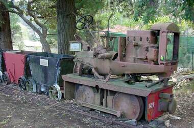 Puffing Billy Railway
Day's Petrol Rail Tractor, Petrol Rail Tractor Gauge 2'0", circa 1926 - 1940
Rail tractors were popular with Victorian sawmillers. They were generally cheaper than a steam locomotive, required no special qualifications to drive, and used proven power plants for which spares were available locally. The tractor was constructed by Day’s Engineering of South Melbourne which, although better known for its pumping equipment, built more than fifty rail tractors for Victorian sawmillers and other industrial tramway users. W. Day & Sons is believed to have constructed its first light railway locomotive in 1926. From then until the mid 1940s, the firm appears to have built at least fifty locomotives at its premises in South Melbourne, of which roughly half were four-wheel locomotives and roughly half were six-wheel locomotives like the restored Day’s rail tractor formerly operated by Ruoak Timbers. Of the four-wheel locomotives, ten were 2-ft (610mm) gauge locomotives similar to this one. Today, only two survive, a complete example at the Puffing Billy Railway Museum at Menzies Creek, and one at Alexandra Timber Tramway Museum This 2-ft gauge 4wPM locomotive is believed to have been one of two Day's Petrol Rail tractors formerly used by Cheetham Salt, possibly at the Moolap works near Geelong. Service History :owned by Cheetham Salt, Moolap ( dates unknown ) Geelong Steam Preservation Society , Belmont 1973 ? Puffing Billy Steam Museum , Menzies Creek Historic - Industrial Narrow gauge Railway - Rail Tractor used by Cheetham Salt Company works at Laverton, Moolap and Geelong, Victoria , Australia Petrol Rail Tractor made of Iron , wrought iron, steel puffing billy, industrial narrow gauge railway, rail tractor, days engineering, cheetham salt,, petrol rail tractor -
 Melton City Libraries
Newspaper, Melton Schools-150 years in Melton, 2005
Melton South "The establishment of a settlement of Melton South was induced by the opening of the railway in 1884. This subsequently prompted a number of industries, initially sawmills, and in the early twentieth century, chaff mills. This development coincided with the Exford ‘Closer Settlement’ estate at the beginning of the new century, boosting local population and produce, and the development of the chaff industry which employed many people in the Melton area. (Around 1912 the government had brought out English migrants to settle the Exford estate.) By c.1912 the small Melton Railway Station settlement had a boarding house (probably for chaff or sawmill employees), store, a small church and a hall. The Melton Valley Golf Club originated near the railway station in 1927 (in 1931 it moved to the present Melton links). In 1910 the community had built the large timber ‘Victoria Hall’, which became the focus of community life for several generations. In August of that same year AR Robertson MP and D McDonald applied for the establishment of a school on land set aside for that purpose by the Closer Settlement Board, near the Melton Railway Station settlement. District Inspector McRae recommended that a school for classes up to Grade 3 be established as an adjunct to the Melton State School. And so SS3717, ‘Melton Railway School’, was established in the leased Victoria Hall on 1st December 1911. Thomas Lang, head master at Melton since 1896, was in charge of both schools. As a ‘prep’ school only, it was necessary that the older Melton Railway Station settlement students travel to Melton SS430 at Unitt Street. Since 1912 local residents had been petitioning for the establishment of a separate school at Melton Railway Station on the grounds that it would be better if all children from the one home could attend the same school, and that the Victoria Hall was unsuitable as a school building. As a result an area of 2 acres - Allotment 8, Parish of Djerriwarrh, Exford Estate - was reserved for a State School on 4th March 1914. However the Department wrote that a school would not be established there in the near future, as ‘there is no likelihood in sight that the Railway Station settlement will increase in importance’. Parents persisted with their petitions to the Education Department, claiming that the Victoria Hall was too large, had no fireplace, that teachers were unable to use the wall for teaching aids, and that, being less than 20 metres away from a chaff mill employing 30 men, was too noisy. The turning point came when in 1920 the Hall Committee decided to increase its rent for the hall. In 1920 Head Teacher Lang advised the Education Department to discontinue SS3717 as an adjunct. The District Inspector supported this recommendation, and the schools separated in 1923. In April of that year 41 children, comprising Grades 1-8, moved into an almost completed brick building on the present site. On the 6th July 1923 the official opening of the school took place; after a ceremonial journey from the Hall to the school, speeches were given by the Hon AR Robertson and the Chief Inspector of Education. Everyone then journeyed back to Victoria Hall for a ‘bountiful repast’. (These dates are at odds with the date of 5th March 1925 given in Blake as the date the children occupied the new SS3717 brick school building. ) A teacher’s residence had been purchased for ₤500 in 1923, and the school’s name was changed to ‘Melton South’ in the same year. Even though the older Melton South pupils would no longer have to travel to the Unitt Street school, an additional brick room was still required at the Melton SS430 in that same year. In 1961 a new room was added to the school. In 1972, at the beginning of Melton’s boom as a satellite town, the number of enrolments was 224. The school has since shared in the exponential growth of the town of Melton, and at the time of its jubilee celebration (1983), 524 pupils were enrolled. Victoria Hall, neglected and vandalised, was demolished in 1992. It had been handed back to the Council on condition that it be replaced by a new hall, with the same name, and was commemorated by a plaque. Apart from the 1923 brick school building, and the railway station, none of the principal early Melton South public sites survive. Few early residential sites remain. (Further research will establish whether the house on the corner of Station Street and the railway line was the original teacher’s residence.)" Melton State School "On 17th May 1858 a State subsidised, combined Denominational School was opened by HT Stokes, with an attendance of about 30 children. This school was conducted in the wooden Melton Combined Protestant Church, situated on ‘a creek flat’ thought to be on the north side of Sherwin Street between Pyke and Byran Streets. It is likely that the Church had been established by 1855 and that the first minister was the Rev. Hampshire, who lived in Cambridge House on the Exford Estate. Ministers of the Protestant denominations were invited to hold services there. As there was only one resident Minister in the town (Presbyterian Mr J Lambie), laymen of the various denominations often spoke on Sundays. In 1863 this building was declared a Common School with the number 430. One of its first and most prominent headmasters was John Corr, who served from 1860 to 1864. Most of Mr Corr’s children also became teachers, including Joseph Corr, at the Rockbank school, and J Reford Corr and WS Corr, headmasters and teachers at numerous prestigious private secondary schools around Australia. John Corr purchased land alongside the school and elsewhere in and near Melton, became secretary and treasurer of the new Cemetery Trust, and by July 1861 was deputy registrar of births, deaths and marriages. He walked three miles every Sunday to teach at the Weslyan Sunday School he had established. Despite good reports from the Education Department Inspector, and burgeoning enrolments, the local school committee recommended the dismissal of, firstly, his wife (from the work mistress position), and then him from the headmaster position. Corr saw his dismissal as an attempt to redirect state aid for education from the Combined Protestant school to the support of the Free Presbyterian Minister Rev James Lambie (by one account the owner of the land on which the Common School was erected), whose son-in-law James Scott subsequently assumed responsibility for the school. Rev Lambie failed in his efforts to keep the existing school, which the Education Department Inspector and the majority of Melton citizens regarded as badly situated and badly built. Following a conditional promise of state aid, local contributors in 1868-69 raised ₤72.10.6 towards the cost of an iron-roofed bluestone rubble building 43 ft x 12 ft. This was erected on a new site of 1.5 acres (the present site). The State contributed ₤120 to the new school, which opened in 1870. A very early (c.1874) photograph of the school shows its headmaster and work mistress / assistant teacher (probably James Scott and his wife Jessie) and its (very young) scholars. Similar photos show pupils in front of the school in c.1903, and 1933. In 1877 a second bluestone room costing ₤297 was added and further land acquired from the Agricultural Society (who only needed it two days a year) to enlarge the schoolground to 3 acres. In the early 1880s an underground tank augmented the school water supply and in 1919 a five-roomed wooden residence was added. During this period the school correspondents often compained that the walls of the bluestone buildings were damp, affecting the plaster. In 1923 a brick room 26 ft 6 in by 24 ft with a fireplace and four rooms facing south, was added, and a corridor built to link the three buildings. This served adequately for the next 40 years. The school bell probably dates to 1883. The school also has a memorial gate (1951) to World War One ex-students, and an honour board to the 64 ex-students who served in the First World War. The school roll fell to 42 in the early post war-years, but was boosted by an influx of migrants, mainly from the UK, from the late 1960s. This presaged the boom in Melton’s development, and the corresponding growth of the school, with timber and temporary classrooms added to the previous masonry ones. An endowment pine plantation established in 1930 augmented the school’s fundraising activities when it was harvested in 1968. Part of the site was planted with eucalyptus trees in 1959. Famous ex-students of the early twentieth century included Hector Fraser (internationally successful shooter) and cyclist Sir Hubert Opperman". The Express Telegraph articles about the history of Melton South and Melton State Schoolseducation -
 Bendigo Military Museum
Card - CARD, BOER WAR, Pre 1900
Post card Boer War sent from South Africa by Otto J LUCKWALL, 5th Vic Mounted Rifles to his sister. Otto was from Bendigo. The card has pressed leaves & photo inside. Fawn cardboard two page folded card with gold lettering on front. Sepia photo inside front cover of camp scene with soldier standing on guard with rifle. trenches in foreground, Three pressed leaves inside. Back cover with red, white & blue bow joining the leaves at their stems.Printed on cover: “Everlasting Silver Leaves From Table Mountain Cape Town South Africa” On L leaf: “Loving Greetings” On R leaf: “To my dear sister” cards, boer war, silver leaves -
 Friends of Westgarthtown
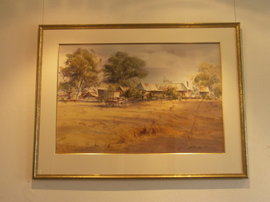
Painting, John Borrack, Last Days Ziebells "The Pines" Thomastown
Painted from the home (or front) paddock which ran south to the creek. The paddock was used for the cultivation of lucerne and maize crops in the lower regions while closer to the house where Ainwick Crescent is now situated, it was a burgeoning market garden for the cultivation of all varieties of vegetables. The large pines beyond, sheltered the farmyard on the west of Gardenia Road. That complex can be partly glimpsed on the left of the painting. This is a directly painted watercolour relying on the use of white paper and transparencies to impart a feeling of morning light. The figure is the artist's mother for whom the picture was painted. Provenance: Augusta Borrack (nee Ziebell) Collection, John Borrack CollectionWatercolour painting, depicting Ziebell's Farmhouse from the south (Thomastown and Mernda). Painting is mounted in a gold frame with cream board.Artist signature: John Borrack; Last Days at Ziebells "The Pines" Thomastown, 'Pro mea matre hanc picturan feci (In Memoria)'illustrations, watercolours, john borrack, ziebell, watercolour, painting -
 Glen Eira Historical Society
Album - Album page, Bureel (Kooyong Road), Circa 1972
This photograph is part of the Caulfield Historical Album 1972. This album was created in approximately 1972 as part of a project by the Caulfield Historical Society to assist in identifying buildings worthy of preservation. The album is related to a Survey the Caulfield Historical Society developed in collaboration with the National Trust of Australia (Victoria) and Caulfield City Council to identify historic buildings within the City of Caulfield that warranted the protection of a National Trust Classification. Principal photographer thought to be Trevor Hart, member of Caulfield Historical Society. Most photographs were taken between 1966-1972 with a small number of photographs being older and from unknown sources. All photographs are black and white except where stated, with 386 photographs over 198 pages. From: Glen Eira Heritage Management Plan 1996 by Andrew Ward In 1856, John Allee, a builder from Brighton, purchased C.A. 37 on the south-west corner of Glenhuntly and Kooyong Roads. The land comprised just over 45 acres. By 1863, Francis John Sidney Stephen, a lawyer and cousin of J. Wilberforce Stephen, owned most of lot 37. By 1866, Stephen had a built a "small mansion" named ''Burreel". It was a brick house and Stephen lived there until 1882. By 1884, Mrs Buxton of Hillside Terrace, East Melbourne, had purchased the property. Richard Buxton, a gentleman was listed as occupant and the house described as "brick, eight rooms". NAV was £300. Richard Buxton continued residency in 1887 however in 1888, George Allen, music seller, became occupant. At that time the house had thirteen rooms on twenty-three acres of land. Twelve people lived there and NAV was £920. In 1900, Daniel Luxton, stock and sharebroker and the Honourable John Taverner, M.H.A. leased the property. Fourteen people lived there. Mrs Buxton continued as owner. By 1910, ownership had passed to Mrs Mary Neate, who converted the house to a nursing home. The land had been subdivided by 1913 and sold by ''Buxtons Estate". Burreel Avenue, Baxter, Buxton and Hoddle Streets were created. "Burreel" was rated to Burreel Avenue and stood on lot 13 with frontages to Burreel Avenue and Kooyong Road of 198' and 214'. The house had ten rooms. NAV was £60. Mary Neate, a nurse, continued as owner/ operator of ''Burreel" nursing home in 1927. At that time there were sixteen rooms and fourteen residents. NAV was £100. Mrs Neat remained there until 1947. In 1948, the house was turned into apartments. In the 1980's, the Alexander family purchased it and restored it to a private residence.Burreel 331 Kooyong Road, ELSTERNWICK VIC 3185 - Property No B4950 National Trust https://vhd.heritagecouncil.vic.gov.au/places/65648 This is a large and substantially intact example of the grand villas of nineteenth century Melbourne. The bulk of the house most probably was built in 1866-1868 for Francis John Sidney Stephen, a prominent and highly regarded Melbourne solicitor and a member of an illustrious legal family. Stephen conducted a lucrative private practice and in 1845 was appointed first solicitor to the City of Melbourne; a position he held until his death in 1895. He took an active part in the development of Caulfield and was Shire President in 1874 and 1877. He was a resident at Burreel from 1868 to 1882. The house has evolved in stages, the rear wings possibly remaining from a house built during the 1850s. The existing ornate cast iron verandah was probably built between 1882 and 1888 during the residence of Richard Buckhurst Buxted, a notable boom period auctioneer and real estate agent. George Allan, the founder of Allan's music store, was another important occupier from 1888 to 1991. Bureel's essentially residential quality has been retained and the interior has been well preserved. The significance of this building does not rest in any single unusual outstanding architectural feature, or in its association with a particularly prominent member of society in the past, but rather in the consistent integrity of both the interior and exterior, which results in the survival of an outstanding example of this type of residential building and its associations with two notable citizens. Classified:11/08/1990Page 113 of photograph album with 1 photograph of Burreel in its garden.Handwritten: Bureel [top left] / 113 [bottom left]trevor hart, caulfield, caulfield north, kooyong road, thomas king, mansion, 1860's, bureel, burreel, francis john sidney stephen, city of melbourne, shire president, 1850's, verandah, nursing home, john allee, ornamented corner stones, new orleans manner, plaster rendered, mrs luxton, vincent willis, alexander family, victorian architectural style, ornate cast iron work, lawyers, brick houses, richard buxton, richard buckhurst buxton, george allen, george leavis allan, allans music, daniel luxton, john taverner, mary neate, buxtons estate, land subdivision, mary neat, gardens -
 Australian Commando Association - Victoria
Book, David Dexter Australian War Memorial, Australia in the War of 1939-45 ARMY The New Guinea Offensives
marked "South Africa"non-fiction -
 Running Rabbits Military Museum operated by the Upwey Belgrave RSL Sub Branch
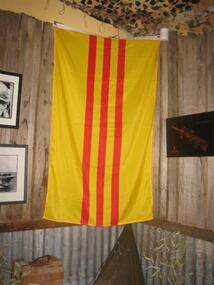
Flag
South Vietnam Flagflag/banner -
 Running Rabbits Military Museum operated by the Upwey Belgrave RSL Sub Branch
Flag
South Korean Flagflag/banner, general -
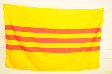 Running Rabbits Military Museum operated by the Upwey Belgrave RSL Sub Branch
Flag
Flag South Vietnamflag/banner, vietnam, army -
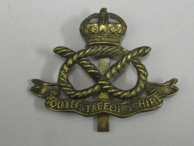 Running Rabbits Military Museum operated by the Upwey Belgrave RSL Sub Branch
Hat Badge
South Staffordshire Regimentbadge/buttons, ww1, army -
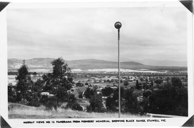 Stawell Historical Society Inc
Photograph, Panorama of Stawell from Pioneer's Memorial, towards the Black Range. Murray Views No.13
Murray Views No. 13. Panorama over Stawell, looking South West. Spotlight on Pioneer's Memorial (29,5). Black Range in background, grassland on Big Hill at front of Photo. St Patrick's Church visible, Kinsella House. The larger photo 29.5a is a slightly closer view of same scene and shows the "new" school (corner Patrick & Holt Street) opened in 1934.Two similar views of Stawell. One Murray views looing south west (29.5) and the other a larger photo showing school building beside church (29.5a).Murray Views No.13. Panorama from Pioneer's Memorial, showing Black Range, Stawell, Vic. (on 29.5)stawell, panorama -
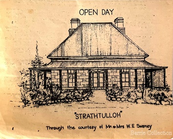 Melton City Libraries
Drawing, Open Day at Strathtulloh, Unknown
"Strathtulloh, 1402-1600 Greigs Road, Melton South, is significant as an early property in Victoria, retaining different eras of pioneering dwellings, ranging from a ruin to a fine Colonial style homestead. The property has close historical association with the early settlement of the Melton district, and was owned by the Henty family in the 1840s. The Strathtulloh property was alienated by the Crown in 1840 to Charles James Garrard, who sold it in 1848 to Charles and Stephen Henty, whose sister Jane and her husband Samuel Bryan lived there in the late 1840s. In 1853 the property then passed to William Tulloh, after whom the homestead was named. A primitive bluestone ruin of near the Toolern Creek, built of vesicular bluestone and mud mortar, is of unknown origin. It has commonly been assumed to pre-date 1840, and to have belonged to the original holder of the Exford lease, Dr Watton or Port Phillip Association member Dr Cotterill. This is unlikely, as the 1841 census records Dr Watton, and everyone else in the district, as living in a ‘wood’ dwelling. It may instead have been the residence of Garrard, and the Bryans, in the 1840s and an early map names a site near here as ‘Bryan’s outstation’. It is assumed that the two-level stone building that became the kitchen is the earliest intact building on the site, and was the first homestead; it is likely to date to the 1840s or 1850s. The main homestead is a substantial villa constructed of random coursed bluestone, with a verandah facing three sides, attic bedrooms with dormer windows, a fan light over the front door, a hipped roof originally clad in slate, and a large cellar. Although demonstrating characteristics of pioneering construction, such as unworked log beams, pit sawn beams, hand-sawn lintels and colonial door locks, documentary evidence shows that it was built c.1869. The homestead has now been structurally repaired and decoratively restored; a sympathetic new semi-detached rear extension was added in the early years of the 21st century. The former kitchen building has also undergone minor repairs and alterations". Strathtulloh Homestead at 1402-1600 Greigs Road, Melton Southlocal architecture -
Whitehorse Historical Society Inc.
Document, My memories of the area around Simpson Park, 1/10/2003 12:00:00 AM
Memories with promptings from Jack Leach who lived in Rupert Street and later in Creek Road.Memories with promptings from Jack Leach who lived in Rupert Street and later in Creek Road. Describes that part of Mitcham south of the railway line between Creek Road and Cochrane street. A sketch map of the area as it was in the 1930's is also supplied.Memories with promptings from Jack Leach who lived in Rupert Street and later in Creek Road.brunswick road, mitcham, creek road, mitcham, cochrane street, mitcham, rupert street, mitcham, bloom family, leach, jack, leach family, simpson family, ferris, ray, simpson park -
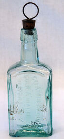 Orbost & District Historical Society
bottle, Early 20th century
Brothers Davis and Lowell Chamberlain, along with their sister Izanna, established what became known as the Chamberlain Medicine Company in 1873. The Des Moines, Iowa-based company eventually stretched to Australia, Canada and South Africa. Chamberlains Colic and Diarrhea Remedy used alcohol, ether, and chloroform to soothe upset stomachs. The company also sold a cough remedy, liniment, pain relief balm and lotion. Chamberlain’s Colic, Cholera and Diarrhea Remedy was one of many thousands of patent medicines that made incredible, and often false, claims about their effectiveness, and became tremendously profitable. Eventually government regulations were put in place to prevent medicine manufacturers from making unfounded claims about their products.This item is an example of a typical "over the counter" patented medicine commonly used by families. It reflect the changes in public health, medical practice and research over the last century.Small green tinted medicine bottle. Writing on front. Cork is attached with wire handle.Front-Chamberlain's Colic & diarrhea Remedy Side- Sydney NSW Side Chamberlain's Ltd Bottom-1185bottle chamberlain's medicine remedies -
 Kiewa Valley Historical Society
Book - Reference S.E.C. History x4, Brown Power A Jubilee History of the State Electricity Commission of Victoria, first published 1969
Although this book revolves around the supply of power(Electricity) from brown coal it does cover the period 1937 onwards when the Kiewa Hydro Electricity Scheme was first mooted. This area was believed to be far away from aerial bombardment should the coastal power stations be attacked by air in World War II(1939 -1945). After the war, post 1945, the demand for a continual power supply, not affected by seasonal coastal flooding was together with a lower cost of hydro electricity power the major incentive for the Victoria Government of the day to proceed (in the 1940s) with The Kiewa Hydro Electricity Scheme. In 1946 Victorian government sought greater independence from the New South Wales black coal supplies.The significance of this book to the Kiewa Valley and its outlying regions is that it details why the development of an Alpine region was and now still is pocketed with a European flavour both in buildings and in town vegetation(trees and flowers). European (post World War II refugees) where attracted to these alpine areas not only for hard labouring positions but also for their technical skills and some street names offer a distinct European lineage rather than convict or of earlier English settler. The construction phase accommodation continued after completion of the Kiewa Hydro Electricity Scheme to become popular venues for an increasing winter tourism industry. This book has a brown hard cover encapsulated by a cream sleeve with brown and black print. On the front of the sleeve is an embossed circular motif with centre piece S.E.C. emblem and around this the words "50 YEARS OF SERVICE" and below this" STATE ELECTRICITY COMMISSION OF VICTORIA". The book contains 313 double sided pages of black print and black and white photographs.On front of paper sleeve "Brown Power A Jubilee History of the State Electricity Commission of Victoria Cecil Edwards". On the second page, below the Title "Brown Power" there is a pasted, printed presentation certificate, with the S.E.C. emblem and these printed words " Presented by the Chairman and Commissioners to A.G. MILLIST, ESQ. in recognition of long and valued service with the Commission"electricity, victorian power supplies, hydro electricity, brown coal, cecil edwards -
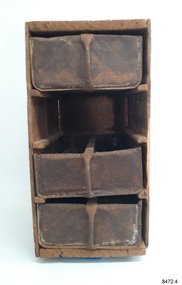 Flagstaff Hill Maritime Museum and Village
Domestic object - Chest of Drawers, British Imperial Oil Company Ltd, 1905-1927
This early 20th-century chest of drawers is unique. It was made from recycled timber kerosene boxes and metal tins. The case was made in South Australia between 1905 and 1927 by the British Imperial Oil Company Ltd, which was the first business to import bulk petroleum products into Australia. Before this, ships carried crates of kerosene as cargo. Items salvaged from the 1880 wreck of the vessel Eric the Red included kerosene boxes. Kerosene replaced plant and animal-based fuel, such as whale oil, for lighting in homes and for the lamps in lighthouses and on marine vessels. It was also used for cooking and heating and as engine fuel. The last kerosene-fueled lighthouse lamp was transferred to solar power in 1985. The chest of drawers is one-of-a-kind. The original uses for the components of the chest of drawers, the wooden box and metal tins were for containing and transporting kerosene. Kerosene was used from the late 19th century for fuel in lamps, heating, and cooling. Previously whale oil was used for the lamps in lighthouses. The company providing the kerosene was the first to import it into Australia in bulk quantities. The set of drawers is one of the many ways that inventive Australians were able to repurpose materials.Chest of drawers; wooden frame and rails, metal drawers with vertical metal handles. The frame has been constructed from the wooden panels of a vintage oil and kerosene box. The three drawers have been created from empty kerosene cans that were cut in half from top to bottom, some with the round opening closed over. Inscriptions from the original box and cams are stencilled on the top and base of the frame and impressed or painted on the metal cans. The frame has provision for a further drawer. The wooden case and metal tins were made in Australia.Top and base of frame; "THE BRITISH IMPERIAL OIL CO. LTD." "OIL ENGINE KEROSENE" "CASE ANDTINS AUSTRALIAN MADE" On tin; "POWIRIN" "BIOCO LTD" Logo [cross} with inscription on horizontal bar "CROSS" Impressed in timber drawer dividers (indecipherable text) Side of drawer, painted in orange on black; "TY -, REG U S - TIDE - "flagstaff hill, warrnambool, maritime village, maritime museum, shipwreck coast, great ocean road, antique, domestic equipment, chest of drawers, tool box, furniture, storage, recycled tin, recycled box, kerosene, fossil fuel, lighthouse lamp fuel, british imperial oil company ltd. -
 Federation University Historical Collection
Book, Prof. Ralph Tate, Papers on Southern Australian Tertiary and Recent Mollusca
An image of contents is available. Ralph Tate (11 March 1840 – 20 September 1901) was a British-born botanist and geologist, who was later active in Australia. In 1875 Tate was appointed Elder Professor of natural science at the University of Adelaide in South Australia, teaching botany, zoology and geology. He became vice-president and then as president (1878–1879) of the Philosophical Society. It changed name to the Royal Society of South Australia in 1880 with Tate as its first president in that year[1] Tate encouraged members to send in original papers, personally contributing nearly 100 papers to its Transactions and Proceedings. (See http://en.wikipedia.org/wiki/Ralph_Tate)Blue half leatherbound book of 422 pages. Includes many black and white illustrations of shells. The book includes a series of articles by Prof. Ralph Tate from transactions of the Royal Society of South Australiasouth australia, ralph tate, royal society, royal society of south australia, gastropods, brachiopods, mollusca, snails, murray river, marine mollusca, brachiopoda -
 Surrey Hills Historical Society Collection
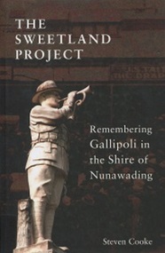
Book, The Sweetland Project: Remembering Gallipoli in the Shire of Nunawading, 2015
A chance viewing of a headstone just south of Anzac Cove in a well-kept lawned cemetery of Australian digger's headstones prompted the research into Stephen James Sweetland of Box Hill and other local diggers and resulted in this book.A chance viewing of a headstone just south of Anzac Cove in a well-kept lawned cemetery of Australian digger's headstones prompted the research into Stephen James Sweetland of Box Hill and other local diggers and resulted in this book.Front page: stamped: DONATION FROM/ BLACKBURN RSL SUB BRANCH/ 2 DIGGERS WAY/ BLACKBURN VIC 3130(mr) stephen james sweetland, world war, 1914-1918, gallipoli, anzac cove, military history, army -
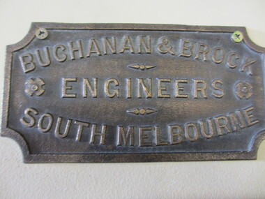 Seaworks Maritime Museum
Plaque
Small metal plaque"Buchanan & Brock/ Engineers/ South Melbourne" -
Glenelg Shire Council Cultural Collection
Souvenir - Cloth Badge - Great South West Walk, n.d
Cloth badge, triangular, white background, black lettering; black emu in triangle bordered in black; white embroidered border on badge; white backing.Front: 'GREAT SOUTH WEST WALK'souvenir, great south west walk, recreation, sport, walking, coastal -
 Buninyong & District Historical Society
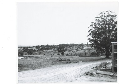
Photograph - B/W photograph, 1970
Early photograph taken in 1969 showing first buildings of Mount Helen Campus of Ballarat University built on early estate near Green Hill. Significant tertiary institution established in the historical pastoral area of Green HillBlack and white photo of early buildings of Mount Helen Campus of University of Ballarat South West Corner of North Wingeducation, green hill, mount helen, university, trees -
 Whitehorse Historical Society Inc.
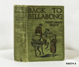
Book, ' Back To Billabong'
Green Covered Book(Inside Cover) Brookdale, Traralgon Southbooks, fiction -
 Whitehorse Historical Society Inc.
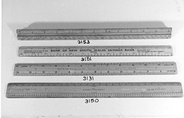
Tool - Ruler
From the Betty McPhee ruler collectionWooden ruler used as a promotional ruler. Inscribed with rules of Police Traffic School. Measures in inches to one foot and in fours and eights to one foot.Bank of New South Savings Bankschool, equipment, domestic items, writing equipment -
 Lakes Entrance Regional Historical Society (operating as Lakes Entrance History Centre & Museum)
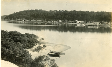
Postcard, 1930c
Two other copies black and white 15.5 x 23 cmBlack and white postcard, taken from across the lake, of the Club Hotel and Stables, Dave Coate's residence, Mitchelson's double story house, Coate Bros Garage (later Crawford's), Robin Hood Inn and Broome's Federal Guest House, launch and houseboat moored in the lake. Lakes Entrance VictoriaLakes Entrance from the South Sidewaterfront, boats and boating, township, retail trade -
 Lakes Entrance Regional Historical Society (operating as Lakes Entrance History Centre & Museum)
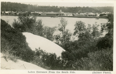
Postcard, 1930c
Other black and white copy 17 x 25 01417.1Black and white postcard of the town, taken from the southern shore of the lake, showing residences, the Central Hotel, butcher shop, bluestone wall at lake edge, and two small jetties. Sand hills and natural vegetation in foreground. Lakes Entrance VictoriaLakes Entrance from the South Sidetownship, waterfront, retail trade -
 Ringwood and District Historical Society
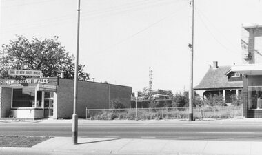
Photograph, Maroondah Highway West, Ringwood- 1969. Looking east from near Wantirna Road
Black and white photographWritten on back of photograph: "May 1969". Image shows 'Bank of New South Wales' on south side of highway. -
 Mont De Lancey
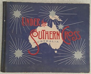
Book, William Applegate Gullick, Under the Southern Cross Australia, 1911
A non fiction book showing full page black and white photograph glimpses of the six states and one territory of Australia in 1910. The ACT is not shown as it was not a territory until 1911. There is simple text describing each photograph at the top and bottom of each page.A blue covered rectangular hardcover book titled in red text and black text on the front cover - Under the Southern Cross with a white map of Australia and Papua with five grey stars of varying sizes with lined rays around each one. Inside on the title page is printed, Glimpses of Australia - Issued under the the direction of the GOVERNMENT OF THE COMMONWEALTH OF AUSTRALIA. Department of External Affairs, Melbourne 1910. On the back of the title page is printed Sydney: William Applegate Gullick, Government Printer for the state of New South Wales. 1911 above an ornate lined symbol. Opposite the title page is a detailed map of Australia showing six states, the Northern Territory but not the ACT which didn't become a territory until 1911. The ACT (Self-Government) Act 1988 established the framework for the ACT Self-government.non-fictionA non fiction book showing full page black and white photograph glimpses of the six states and one territory of Australia in 1910. The ACT is not shown as it was not a territory until 1911. There is simple text describing each photograph at the top and bottom of each page.australia, australian states, australian territory, australian life, australian cities -
 Melton City Libraries
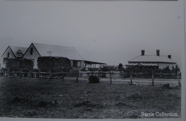
Photograph, Chaff cutting and hay-pressing mills, 1909
In the early 1900’s Charles Ernest Barrie and his brother Ted were in partnership in a Chaff cutting and Ha y processing Mill on the corner of Station and Brooklyn road Melton South. By 1906 Charles Ernest and James Edwin were in partnership in the Station Road mill when a connecting rail line across Brooklyn Road for a siding was constructed to the Melton Railway Station. In 1911 the Mill’s letterhead shows C.E. BARRIE Hay Pressing and Chaff Cutting Mills. This Mill as sold to H S K Ward in 1916 and stood until 1977 when it burnt down in a spectacular fire.Owned by C.E Barrie. Buildings were on the west side of Station Road in Melton South, 100 metres north of Brooklyn Roadlocal identities, pioneer families, agriculture -
 Melbourne Tram Museum
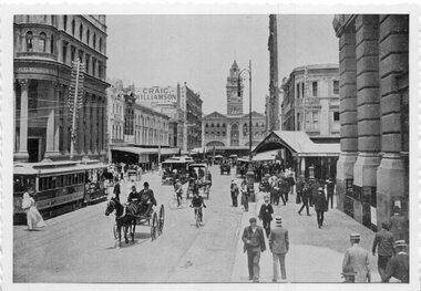
Photograph - Black & White Photograph/s, c1905
Photographs, Black and White, Photo of Elizabeth St, to the north of Collins St looking south towards Flinders St and Flinders St Station. Has a bogie cable trailer in the view, along with other cable trams, horse drawn vehicles and many pedestrians. In the background is Royal Bank, Craig Williamson, Sargent's Cafe and R. White on the corner. The photograph has a serrated edge.In ink on the rear: Keith Kings stamp and number S-A-449 "Melbourne - Elizabeth St, looking south over Collins St. About 1900. Note Bogie Cable Trailer"trams, tramways, elizabeth st, collins st, cable trams