Showing 15563 items
matching stillwell-valley
-
 Greensborough Historical Society
Article, Laurie McQuade, by Rosie Bray, 2019_
Laurie McQuade is a Watsonia resident, who has volunteered for many years as a Scout leader, member of the Yarrambat CFA and St John's Ambulance. He has received many awards, and is still an active volunteer at the age of 83.3 p. typescript, coloured photographs; with newspaper clipping from Diamond Valley News 23/11/2018laurie macquade, watsonia -
Glenelg Shire Council Cultural Collection
Article - Newspaper Clipping - 'Heritage Valley' subdivision at Cape Bridgewater, n.d
Black and white newspaper advertisement for 'Heritage Valley' subdivision at Cape Bridgewater. Elders and Hedditch Real Estate Agentscape bridgewater -
 Halls Gap & Grampians Historical Society
Photograph - B/W, C 1960s
This photo was taken in the Mt William area and was material for a Ministry of Tourism campaign.The photo shows a man seated on a rock and looking out over a valley (Mt William area, south west)'This Photograph is with, The Compliments of The . . . ,Ministry of Tourism, Government of Victoria, Please acknowledge, Photo: Michael Chesire' stamped on back. 'Grampians Mt. William' written on back in red pen.scenery, mount william -
Ringwood and District Historical Society
Envelope, Packet: Dandenong Creek Committee - notes re DVA, Consultation Committee. Correspondence. 1990s
16 pages typed and some handwritten notes Dandenong Valley Authority, Dandenong Creek Community Consultative Committee -
 Flagstaff Hill Maritime Museum and Village
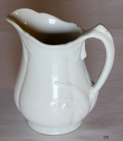
Ceramic - Jug, Baker & Co, 1891 to 1893
W Baker and Co-produced many different types of pottery at their Fenton Potteries, Stoke-on-Trent, Staffordshire England. The company was established in 1790 by Ralph Bourne and William Baker the company was working at capacity by the end of the century. By the late 1820's Bourne and Baker, in partnership with John Bourne, had acquired additional works opposite the first in 1833. With the deaths of John Bourne and William Baker, the partnership was dissolved, and then for a short time, the business was carried on by Ralph Bourne and William Baker junior and John Baker. By the early 1840s, William Baker was running it alone and was then using 'machinery for the potteries manufacturing operations in addition to the mill that was producing the raw clay. The business was subsequently carried on by William Baker and Company that were known for the making of printed, sponged, and pearl-white granite ware for export in the early 1880s at the Fenton works between Manor and Fountain Streets. The original works on the south side of City Road were by then an en-caustic tile works, apparently still in the hands of the Baker family. The pottery works flourished under William Baker’s management and by the middle of the nineteenth century with almost 500 employees was the biggest firm in Fenton. An early piece of ironstone Staffordshire pottery now a collector's item showing the types of domestic items that were exported from England to its colonies towards the end of the nineteenth century and into the beginning of the twentieth.Water pitcher ironstone ceramic white with raised embossed Lilly of the valley decoration around handle and lip sections. Marked on bottom, "Royal stone china, Baker and Co, England" with emblem of lion, crown and unicornflagstaff hill, warrnambool, shipwrecked coast, flagstaff hill maritime museum, maritime museum, shipwreck coast, flagstaff hill maritime village, great ocean road, jug, kitchen utensil, kitchen ware, water pitcher -
 Flagstaff Hill Maritime Museum and Village
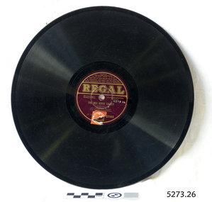
Gramophone Record
Bakelite record by Regal T1232 "The Red River Valley" sung by baritone Art Leonard No G21555 Record cracked.flagstaff hill, warrnambool, shipwrecked-coast, flagstaff-hill, flagstaff-hill-maritime-museum, maritime-museum, shipwreck-coast, flagstaff-hill-maritime-village -
 Whitehorse Historical Society Inc.
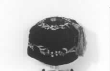
Clothing - Smoking Cap, c1860
Smoking caps, also known as lounging caps, were Victorian headwear worn by men while smoking to stop their hair from smelling of tobacco smoke. Owned by the father of the donor.Black cap with a lily of the valley design around the side and on the crown, and a green and yellow tassel attached. Victorian era.costume, male headware -
Hume City Civic Collection
Print, 1993
The coloured print features the railway bridge which spans the Rupertswood Cutting and is north of the Sunbury Railway station. The Rupertswood Mansion is also featured in the distance.A coloured print with a white border of a rural landscape in a valley featuring a bridge in the middle distance and a large building in the distance.A.Rafferty 93bridges, rupertswood cutting, rupertswood, railways -
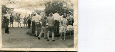
 Diamond Valley Vietnam Veterans Sub-Branch
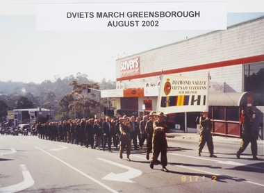
Photograph - VV Day, c2002
Photo: DViets Vietnam Veterans Day March, August 2002 - marching up Main Street, Greensborough.Historical record showing marching members in 2002..Color photograph of Diamond Valley Vietnam Veterans marching on Main Street, Greensborough, VV Day August 2002.Text in photo: DViets Vietnam Veterans Day March, August 2002vietnam, vietnam war, diamond valley vietnam veterans sub branch, long tan day, vietnam veterans day -
Canterbury History Group
Document - "Mirabella" 62 Wattle Valley Road, 1986: P. Sanders P/L & Graeme Butler, 1991: Dr Chris McConville & Graeme Butler, 1991
City of Camberwell Urban Conservation Study 1986, 1991 report on "Mirabella" 62 Wattle Valley Road Canterbury.canterbury, wattle valley road, zelman> victor a, gordon garrett & co, historic buildings register, historic buildings, p.sanders p/l, butler> graeme, mcconville> chris (dr), national trust of australia, city of camberwell urban conservation study -
Canterbury History Group
Photograph - Bradshaw's BP / COR Garage Canterbury, 1960
Black and white photograph of Bradshaw's BP / COR Garage Corner of Wattle Valley and Canterbury Roads Canterbury 1960canterbury, wattle valley road, canterbury, d.h. bradshaw auto service pty ltd, petrol stations, olympic torch, canterbury mansions -
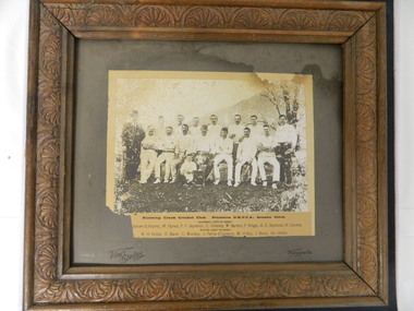 Kiewa Valley Historical Society
Photo - Running Creek Cricket Club
Running Creek belonged to the Upper Kiewa Valley Cricket Association and were premiers in 1913 - 1914. They dressed in whites with long sleeved shirts and trousers. The umpire was dressed very formally. The names of the players are local families and included brothers or relations with the same surname.Historical: Running Creek were premiers of the Upper Kiewa Valley Cricket Association in 1913 - 1914. Their team consisted of local men some of whom were related. The occasion was important enough to have a photo and to remember it possibly hanging the photo up in a public place eg. club rooms.Black & white photo of Running Creek Cricket Team, Premiers 1913 - 1914. Upper Kiewa Valley Cricket Association Far left - The umpire fully dressed in suit & hat and far right man with white shirt & black trousers. In between 13 cricketers in 2 rows and a child beside the cup at the front. Names of players are typed below the photo. Photo is glued on grey cardboard, framed in brown decorative wooden frame. Back: String attached 1 side only.Title, names of players. Grey cardboard - Vine's Studios / Wangaratta. On back handwritten "Donated by Mrs J. Woodside / Guluguba / Queensland / on 19 July 1972cricket. running creek. upper kiewa valley cricket association. sport. vine's studio. -
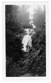 Marysville & District Historical Society
Photograph (item) - Black and white photograph, 1935
An early black and white photograph of Steavenson Falls in Marysville in Victoria. An early black and white photograph of Steavenson Falls in Marysville in Victoria.The Steavenson Falls is named after the Victorian Assistant Commissioner of Roads and Bridges, John Steavenson who arrived in Victoria in the early 1860s. The photograph has been incorrectly labeled as Cumberland Valley.Cumberland Valley Trip-Marysville N 561 30 Kodak/ Printsteavenson falls, marysville, victoria, waterfalls, photograph, john steavenson -
 Mission to Seafarers Victoria
Book, Adlard Coles Limited, Passenger Liners, 1965
Description of passengers liners with photographs, funnel colours.Large red cover book (dust jacket missing)non-fictionDescription of passengers liners with photographs, funnel colours.passengers liners, passengers ships, mission to seafarers, seamen, seafarers -
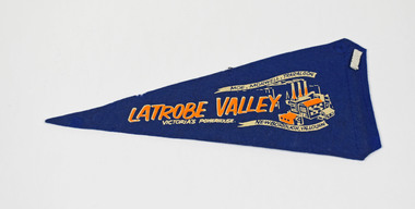 National Wool Museum
Pennant
LATROBE VALLEY VICTORIA'S POWERHOUSE MOE MORWELL TRARALGON NEWBOROUGH YALLOURNlatrobe valley, victoria -
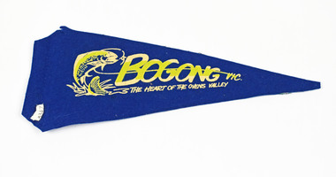 National Wool Museum
Pennant
BOGONG VIC. THE HEART OF THE OVENS VALLEY BOGONG VILLAGE KIEWA SCHEMEbogong, victoria -
 Kiewa Valley Historical Society
Photographs x 2 - Afternoon tea visit to Towong Hill
Towong Hill Homestead is a 110-year-old Federation style mansion situated on a rock outcrop, with views of about 260 degrees. It was built over 2 years by grazier Walter Mitchell from bricks made from local clay dug from the river bank, to be the family home for his new bride Winifred. They established their home in 1904. After the death of Walter in 1917, Winifred relocated her family, but the homestead remained in the families hands. In 1935, Thomas Mitchell (1906-1984) returned home to Australia, a successful Lawyer, and married city girl, Elyne Chauvel, and settled himself back at his childhood home, Towong Hill. Thomas was a world champion slalom skier, had been a prisoner of the Japanese at Changi, and was elected for the Country Party in 1946 and served as attorney-general in the McDonald government. His wife Elayne (1913-2002) is best remembered for her Silver Brumby series of novels for children. But Elyne also wrote a substantial number of non-fiction works about the Snowy Mountains. Photographs demonstrate local Kiewa Valley residents enjoying a community visit to the historic homestead at Towong Hill which holds significance to the early history of the area. Also demonstrates a pictorial history of social activities undertaken during this period2 black and white photographs mounted on buff card. Kiewa Valley residents attending afternoon tea at Towong HillHandwritten in black pen underneath photo - T.W.Mitchell Towong Hill. Afternoon Teat w mitchell, towong hill, kiewa valley -
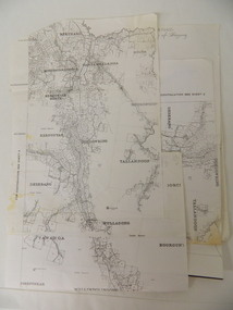 Kiewa Valley Historical Society
Parish Maps - Kiewa Valley
The Parish Maps show how the Counties were divided into allotments for buyers. On one the original owners are named and the sizes of their properties given. The reference numbers enable individuals research the history of the property. The other is on a smaller scale giving only the allotment numbers. The map with the names gives information on the early settlers of the Kiewa Valley. They show how the Kiewa Valley was divided up into allotments for town dwellers and farmers and enables further research.Two copies of Parish Maps of the towns in the Kiewa Valley. One gives the original owners and the other the reference numbers of the allotments.kiewa valley. parish maps. land owners -
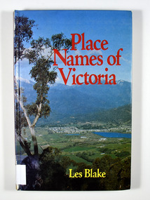 Marysville & District Historical Society
Book, Place Names of Victoria, 1977
Place names of VictoriaHardback. Front cover has a colour photograph of Mount Beauty and Kiewa Valley from the Tawonga Gap (Jocelyn Burt)E.J. Bienvenue Stamp of M. O. Bienvenu / 12 Noonan St. / Wangaratta 3677 Stamp of Marysville & District / Historical Society Inc / P.O. Box 22 / Marysville 3779victoria, place names, geography -
 Greensborough Historical Society
Folder, Rosalie Bray, Local Scene in Watsonia with Rosalie Bray 1986, 1986_
This local news column details events, people and places of interest as they occurred in Watsonia in 1986.This column was a means of advertising for local community groups and gives a snapshot of the Watsonia area at the time.Spiral bound plastic binder with 20 pockets. Contains photocopies of selected articles from Diamond Valley News 1986.watsonia, rosalie bray -
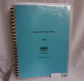
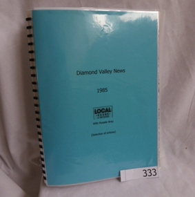 Greensborough Historical Society
Folder, Rosalie Bray, Local Scene in Watsonia with Rosalie Bray 1985, 1985_
This local news column details events, people and places of interest as they occurred in Watsonia in 1985.This column was a means of advertising for local community groups and gives a snapshot of the Watsonia area at the time.Spiral bound plastic binder with 20 pockets. Contains photocopies of selected articles from Diamond Valley News 1985watsonia, rosalie bray, diamond valley news -
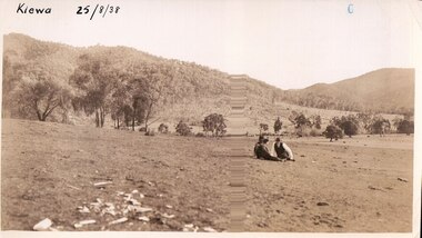 Kiewa Valley Historical Society
Black and white photograph of farmland, Kiewa, 25/8/38, circa 1938
This photograph was taken in August, 1938 at the time of road making in the area and some eight years prior to the establishment of Mt. Beauty township. The area was still being used for grazing, and the land was eventually acquired from the local land owners by the State Electricity Commission. The construction of the road, from Tawonga to the High Plains, was commenced in April of this year. This allowed men and heavy equipment to be transported to the work sites for the construction of the Kiewa Hydro Electric Scheme. An important photograph as it shows the upper Kiewa Valley as it was before the establishment of the town of Mt. Beauty. The land had been cleared of natural growth and has been used for grazing cattle. By 1946 housing construction had commenced for the new town of Mt. Beauty and by 1948 street construction in the southern part of the town was completed as far as Hill Street.A black and white photograph taken in the upper Kiewa Valley showing farmland with a group of three unidentified people sitting on the grass.Handwritten in black ink is the inscription 'Kiewa 25/8/1938'. In the right corner of the photograph has been stamped the number 6. On the back in a circle, some 14mm across, are the words 'Kodak Print'. The word Velox is also printed on the back.kiewa, mt. beauty, construction, grazing, secv -
 Bendigo Historical Society Inc.
Book - BENDIGO LANDSCAPE ASSESSMENT
Bendigo Landscape Assessment Big Hill & Mandurang Valley Drat Report 23 June 2012 contains maps and photographs.surveying, terrestial, mandurang valley -
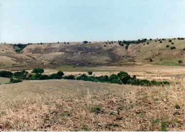 Hume City Civic Collection
Photograph, c 1990s
Canon Gully is situated about 2 km upstream from the railway bridge at Rupertswood. In 1864 it was the site for the military encampment of the Victorian Volunteer Forces. William Clarke allowed the military to stage the annual event on his property. Further encampments were held on this site in 1874 and 1877.A coloured photograph of a wide valley with cleared hills in the background. The tree lined creek or watercourse is across the middle distance of the image.canon gully, rupertswood estate, encampments, clarke, william j. t. 'big bull', victorian volunteer forces, george evans collection -
Whitehorse Historical Society Inc.
Article, Girl's bush survival tale inspires wonder, 2013
Fourteen year old girl lost in the Yarra Valley for three weeks in 1885.Fourteen year old girl lost in the Yarra Valley for three weeks in 1885, which was the inspiration for McCubbin's painting 'Lost'.Fourteen year old girl lost in the Yarra Valley for three weeks in 1885.mccubbin, frederick, crosby, clara -
Whitehorse Historical Society Inc.
Article, Giant digger takes first bite of our new tunnel, 2005
Article on the digging of the Eastlink tunnel through the Mullum Mullum Valley, and political controversy over road tolls.Article on the digging of the Eastlink tunnel through the Mullum Mullum Valley, and political controversy over road tolls. Photo of worksiteArticle on the digging of the Eastlink tunnel through the Mullum Mullum Valley, and political controversy over road tolls. east link eastern freeway extension, tunnel -
Whitehorse Historical Society Inc.
Article, Concept path at square one, 2008
Several groups are in discussion about a proposed route for a path along the Mullum Mullum Valley (photo of Mullum Mullum Creek).Several groups are in discussion about a proposed route for a path along the Mullum Mullum Valley (photo of Mullum Mullum Creek).Several groups are in discussion about a proposed route for a path along the Mullum Mullum Valley (photo of Mullum Mullum Creek).mullum mullum valley, path -
 Kew Historical Society Inc
Photograph - Urban landscape, 1860
An item from an outstanding and diverse photographic collection, assembled by members of the Christian and Washfold families of Kew.Black and white photograph looking across a valley to buildings in the distance. Similar locations in nos.41, 42, 43. 44.subdivisions -- kew (vic.), christian-washfold collection, landscape photography -
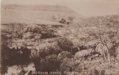 Sunbury Family History and Heritage Society Inc.
Photograph
he photograph was taken of Jacksons Creek near the waterfalls and weir which are downstream from Macedon Street.A sepia photograph in postcard format of a creek with the water tumbling over rocks. The land in the distance rises above the surrounding valley.JACKSONS CREEK SUNBURYjacksons creek, sunbury -
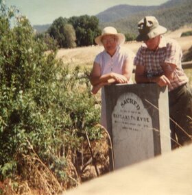 Kiewa Valley Historical Society
Photograph x 2 of pioneer gravesites, 11th January, 1985
Pictorial record of the graves of early pioneers Mrs Elizabeth Eyre who died in 1879 located at Tawonga Homestead and Mary Hollands , located at Mullagong in TawongaRecord of early history of Kiewa Valley pioneers Gwen Hobbs and Rob Hollands are descendants of pioneer farmers. Hobbs and Hollands families have lived and worked in the Kiewa Valley for many years.1. Colour photograph of 2 Kiewa Valley residents visiting gravesites of pioneer Elizabeth Eyre who died in 1879. Grave located at Tawonga Homestead. 2. Colour photograph of Kiewa Valley residents visiting the gravesite of Mrs Mary Hollands, pioneer of the area. Gravesite located at Mullagong property in Tawonga.1. Handwritten in ink on back of photograph: Gwen Hobbs and Rob Hollands - Tawonga Homestead grave 2. Handwritten in ink on back of photograph: Gwen Hobbs and Barbara, Rob and Margaret Hollands at Mullagong graveselisabeth eyre, mary hollonds, tawonga, graves