Showing 10429 items
matching sites
-
 Federation University Historical Collection
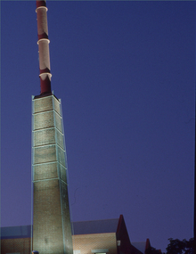
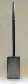
Negative - Photograph, Ballarat School of Mines Brewery Building
A building on the Federation University SMB Campus. It is built on the site of the former Ballarat Brewery.2 transparencies of the Brewery building on SMB Campusbrewery building, ballarat school of mines, buildings, chimney -
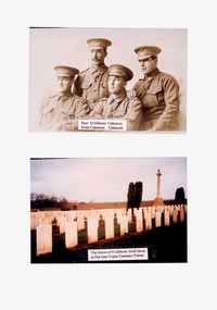 Lara RSL Sub Branch
Photos, H Gibbons, Unknown
Photos of H Gibbons and grave site in Flat Iron Copse Cemetery France2 photos mounted on A4 paperH Gibbons The Grave of H Gibbons Amid those at Flat Iron Cemetery Franceh gibbons flay iron copse france world war 1 -
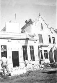 Federation University Historical Collection
Photograph - Photograph - black and white, Probably Keith rash, Ballarat Benevolent Asylum Under Demolition, 1941
The Ballarat Benevolent Asylum was demolished in 1941. The site is now the Queen Elizabeth centre. A man stands in front of a building that is being demolished. Rubble is evident in the foreground. The building is the former Ballarat Benevolent Asylum. Verson: "Benevolent Asylum 1941. Demolition of original first part building of 1857. "ballarat, benevolent asylum, asylum, ballarat benevolent asylum, queen elizabeth benevolent asylum -
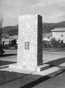 Kiewa Valley Historical Society
Photo - Mt Beauty Cenotaph
The cenotaph was built by Snowy Miller, stone mason. Site of Anzac Day commemorationsStone mason, Snowy Miller (father of Dot Higginson) constructed the cenotaph. He also worked on the Tawonga hall.Black and white photograph of the stone cenotaph in Mt Beautymt beauty centotaph, anzac day -
 Greensborough Historical Society
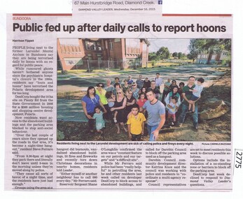
Newspaper Clipping, Public fed up after daily calls to report hoons, 16/12/2015
Local residents complain about 'hoon' behaviour on the Larundel site to be developed into Polaris.News clipping, black text, colour image.larundel, polaris -
 University of Melbourne, Burnley Campus Archives
Newspaper - Newspaper Cutting, The Age, Duo Takes a Punt on Burnley, 2014
Article about the Botanicca Project next to Burnley Gardens (formerly part of site.)Article in "The Age," 14.07.2014 by Susannah Pettythe age, susannah petty, botanicca project -
 Stawell Historical Society Inc
Photograph, Knights Roadside Tearooms site at Halls Gap with the unveiling of a Plaque -- 4 Photos
Unveiling plaque at site of Knights Roadside Tearooms at Halls Gap. Four Photos.grampians -
 Stawell Historical Society Inc
Photograph, Fountain Head Brewery at Armstrong featuring a Slab Hut
Slab Hut Bush scene Brewery Site Fountain Head Brewery at Armstrongstawell -
 Stawell Historical Society Inc
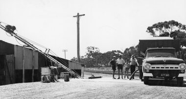
Photograph, Grain Storage Site beside railway line in Griffin Street with a truck unloading
Grain Storage Site beside railway line Griffin Street truck unloading.stawell -
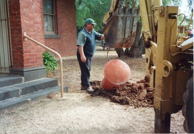 Stawell Historical Society Inc
Photograph, Post Box -- Decommissioned -- being resited near the Old Court House 2000
Post Box being re-sited to grounds of Old Court House 2000stawell -
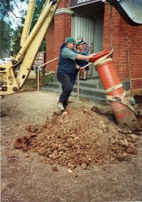 Stawell Historical Society Inc
Photograph, Post Box -- Decommissioned -- being resited near the Old Court House 2000
Post Box being re-sited to grounds of Old Court House 2001stawell -
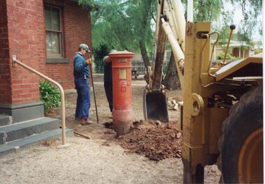 Stawell Historical Society Inc
Photograph, Post Box -- Decommissioned -- being resited near the Old Court House 2000
Post Box being re-sited to grounds of Old Court House 2002stawell -
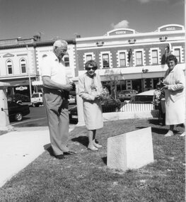 Stawell Historical Society Inc
Photograph, Methodist Church Site Plaque Unveiling with Mrs Swartz nee Unknown in the centre of photo 1999
Plaque Unveiling – Methodist Church Site 1999. Mrs Swartz centre of photostawell -
Stawell Historical Society Inc
Photograph, Joel Joel Primary School Number 1702 site can be seen in the Background
Joel Joel Public Hall Primary School site can be seen in background.stawell education -
 Robin Boyd Foundation
Drawing - Architectural, Monbulk & District Elderly Peoples Homes, Feb-75
Project: drawn by Leslie Jones of Romberg & Boyd. Site Plan and Complex LayoutWorking Drawing, Ink on Tracing Paper -
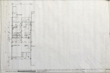 Robin Boyd Foundation
Drawing - Architectural, Monbulk & District Elderly Peoples Homes, Feb-75
Project: drawn by Leslie Jones of Romberg & Boyd. Site Plan and Complex LayoutWorking Drawing, Ink on Tracing Paper -
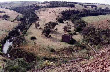 Hume City Civic Collection
Photograph, Bulla Mill
The waterway is the Deep Creek at Bulla. Originally this was the site of one of the earliest mills in the district.In the early days of European settlement a number of mills were established on the banks of both the Jackson and Deep Creeks in Bulla and Sunbury.A coloured photograph of a valley surrounded by hills with the ruins of a stone building on the horseshoe bend of the creek. deep creek, mills, bulla bulla -
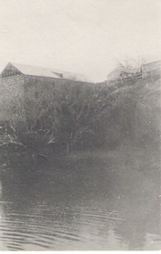 Sunbury Family History and Heritage Society Inc.
Photograph
The large building is a former mill which was sited along the Jacksons Creek in Sunbury.Milling along with vineyards was one of the early agricultural pursuits carried out in the former Bulla Bulla district.A black and white photograph of a large stone building built on a rise above a pond.jacksons creek, mills -
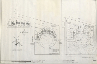
Federation University Historical Collection
Plan, Ballarat Gaol Sewerage Plan (photocopy), 05/1927
The site of the former Ballarat gaol is now part of Federation University's SMB campus.A3 plan with 6 additional works added to original plan. The last addition was 22 August 1947. WGS 84 37 degrees 33 feet 58 inches S 143 degrees 51 feet 24 inches Eballarat gaol, arthur lasser, gaol, ballarat school of mines, buildings -
 Orbost & District Historical Society
butter press
This was found by Kevin Ingram while cleaning the Orbost Butter Factory site in 1991. The Orbost Butter and Produce Co. Ltd was registered on June 1st 1893 and was an important source of income to the Orbost district. A 1 lb butter press with a cylindrical metal handle on a square base. This tool fitted over the butter and pushed it out in a rectangular shape.orbost-butter_factory agriculture farming butter-press -
 Eltham District Historical Society Inc
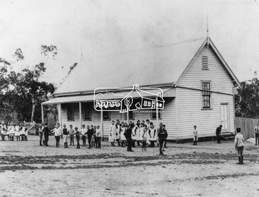
Photograph, Kangaroo Ground State School, c.1900
Built c.1876, the site was purchased in 1874. Reproduced on p25 of 'Pioneers & Painters'This photo forms part of a collection of photographs gathered by the Shire of Eltham for their centenary project book,"Pioneers and Painters: 100 years of the Shire of Eltham" by Alan Marshall (1971). The collection of over 500 images is held in partnership between Eltham District Historical Society and Yarra Plenty Regional Library (Eltham Library) and is now formally known as the 'The Shire of Eltham Pioneers Photograph Collection.' It is significant in being the first community sourced collection representing the places and people of the Shire's first one hundred years.Digital image 4 x 5 inch B&W Neg Print (2) 20 x 25 cm and 9 x 12.5 cmshire of eltham pioneers photograph collection, kangaroo ground, kangaroo ground state school, pioneers and painters -
 Eltham District Historical Society Inc
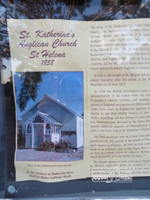
Photograph, Liz Pidgeon, Tour of St Katherine's Anglican Church and cemetery, St Helena, 27 October 2014
One of two photographs of historical information about the site posted in the window of the Church.Born Digitalst katherine's church, st helena, cemetery -
 Eltham District Historical Society Inc
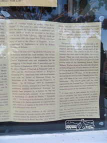
Photograph, Liz Pidgeon, Tour of St Katherine's Anglican Church and cemetery, St Helena, 27 October 2014
One of two photographs of historical information about the site posted in the window of the Church.Born Digitalst katherine's church, st helena, cemetery -
 Eltham District Historical Society Inc
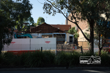
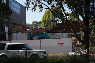
Photograph, Peter Pidgeon, Demolition of former Newsagency, Main Road, Eltham, 3 May 2017
Site of the former Newsagency on eastern side of Main Road. Thompson's Pharmacy to the leftBorn Digitaleltham, newsagency, main road, thompson's pharmacy -
 Eltham District Historical Society Inc
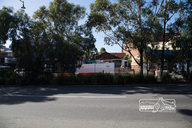
Photograph, Peter Pidgeon, Demolition of former Newsagency, Main Road, Eltham, 3 May 2017
Site of the former Newsagency on eastern side of Main Road. Thompson's Pharmacy to the leftBorn Digitaleltham, newsagency, main road, thompson's pharmacy -
 Eltham District Historical Society Inc
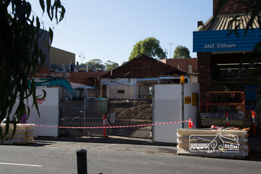
Photograph, Peter Pidgeon, Demolition of former Newsagency, Main Road, Eltham, 3 May 2017
Site of the former Newsagency on eastern side of Main Road. Thompson's Pharmacy to the leftBorn Digitaleltham, newsagency, main road, thompson's pharmacy -
 Eltham District Historical Society Inc
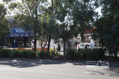
Photograph, Peter Pidgeon, Demolition of former Newsagency, Main Road, Eltham, 3 May 2017
Site of the former Newsagency on eastern side of Main Road. Thompson's Pharmacy to the leftBorn Digitaleltham, newsagency, main road, thompson's pharmacy -
 Eltham District Historical Society Inc
Photograph, Peter Pidgeon, Demolition of former Newsagency, Main Road, Eltham, 3 May 2017
Site of the former Newsagency on eastern side of Main Road. Thompson's Pharmacy to the leftBorn Digitaleltham, newsagency, main road, thompson's pharmacy -
 Eltham District Historical Society Inc
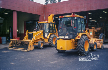
Photograph, Shire of Eltham earthmoving equipment at the Council Depot, Brisbane Street, Eltham, c.1988, 1988c
Site is now Eltham Fort Knox. These registration plates were issued in 1988.Roll of 35mm colour negative film, 7 stripsFuji 100eltham shire council, infrastructure, depot, eltham fort knox, equipment -
Ballarat Heritage Services
Photograph - Black and White, Davies the Baker, Eureka Street, Ballarat
The site of Davies the Baker became a playground west of the Eureka Street Primary School.A wide panoramic photograph showing numerous Davies Bread Bakery trukjs and drivers, and two members of the Davies family. They are standing together and are Frederick Tablot Davies, Mr Davies Senior, and Foreman Hector Godfrey's Smith.davies bakery, eureka street, frederick davies, hector godfrey smith