Showing 7977 items
matching genealogy-research
-
 Ringwood and District Historical Society
Photographs, 1979-80 MMBW pipe line project at Hubbard Reserve, North Ringwood � Sewer tunnel
Part of a 43-photo record of the MMBW�s engineering feat in drilling a 12 inch pipe line up to 40 feet deep through rock hardened by volcanic action associated with geological fault that occurs along the line. The work took place from October 1979 to May 1980 on the southern boundary of Hubbard Reserve, North Ringwood. The collection was presented to the Ringwood Historical Research Group by J Clarke on 9th June 1980.E561 N7 Feb 1980 A43 Work on sewer tunnel below Burlock Avenue. Line of shafts running from manhole in gully to the consecutive groups on top left. -
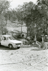
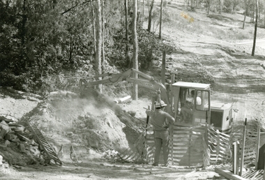 Ringwood and District Historical Society
Photographs, 1979-80 MMBW pipe line project at Hubbard Reserve, North Ringwood � Nissan backhoe digging for the broken mole
Part of a 43-photo record of the MMBW�s engineering feat in drilling a 12 inch pipe line up to 40 feet deep through rock hardened by volcanic action associated with geological fault that occurs along the line. The work took place from October 1979 to May 1980 on the southern boundary of Hubbard Reserve, North Ringwood. The collection was presented to the Ringwood Historical Research Group by J Clarke on 9th June 1980.E563 N4 12 April 1980 A43 Nissan backhoe digging for the broken mole -
 Ringwood and District Historical Society
Photographs, 1979-80 MMBW pipe line project at Hubbard Reserve, North Ringwood � Finished manhole
Part of a 43-photo record of the MMBW�s engineering feat in drilling a 12 inch pipe line up to 40 feet deep through rock hardened by volcanic action associated with geological fault that occurs along the line. The work took place from October 1979 to May 1980 on the southern boundary of Hubbard Reserve, North Ringwood. The collection was presented to the Ringwood Historical Research Group by J Clarke on 9th June 1980.E566 N15 13 May 1980 A43 The finished manhole in the gully. The tall stake is the line of the boundary of Hubbard Park. -
 Ringwood and District Historical Society
Photographs, 1979-80 MMBW pipe line project at Hubbard Reserve, North Ringwood � Air drill rig
Part of a 43-photo record of the MMBW�s engineering feat in drilling a 12 inch pipe line up to 40 feet deep through rock hardened by volcanic action associated with geological fault that occurs along the line. The work took place from October 1979 to May 1980 on the southern boundary of Hubbard Reserve, North Ringwood. The collection was presented to the Ringwood Historical Research Group by J Clarke on 9th June 1980.E561 N18 3 March 1980 A43 Air drill rig at the start of the open cut to Debbie Place. It made 24 holes at a time as each were charged with 10 sticks of gelignite for ripple firing. -
 Ringwood and District Historical Society
Photographs, 1979-80 MMBW pipe line project at Hubbard Reserve, North Ringwood � Broken mole
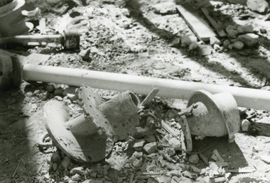
Part of a 43-photo record of the MMBW�s engineering feat in drilling a 12 inch pipe line up to 40 feet deep through rock hardened by volcanic action associated with geological fault that occurs along the line. The work took place from October 1979 to May 1980 on the southern boundary of Hubbard Reserve, North Ringwood. The collection was presented to the Ringwood Historical Research Group by J Clarke on 9th June 1980.E565 N9 16 April 1980 A43 The broken mole back-reamer whose jamming held up the job for four weeks -
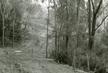
 Ringwood and District Historical Society
Photographs, 1979-80 MMBW pipe line project at Hubbard Reserve, North Ringwood � Viewing east from Debbie Place
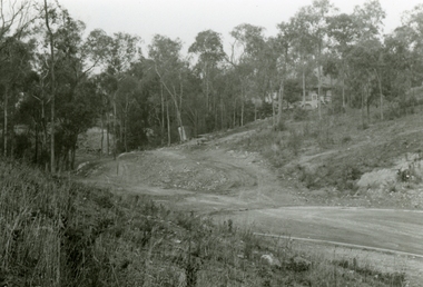
Part of a 43-photo record of the MMBW�s engineering feat in drilling a 12 inch pipe line up to 40 feet deep through rock hardened by volcanic action associated with geological fault that occurs along the line. The work took place from October 1979 to May 1980 on the southern boundary of Hubbard Reserve, North Ringwood. The collection was presented to the Ringwood Historical Research Group by J Clarke on 9th June 1980.E568 N18 13 May 1980 A43 Viewing east from ridge above Debbie Place -
 Ringwood and District Historical Society
Photographs, 1979-80 MMBW pipe line project at Hubbard Reserve, North Ringwood � View east up the gully
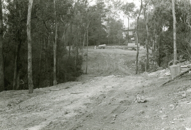
Part of a 43-photo record of the MMBW�s engineering feat in drilling a 12 inch pipe line up to 40 feet deep through rock hardened by volcanic action associated with geological fault that occurs along the line. The work took place from October 1979 to May 1980 on the southern boundary of Hubbard Reserve, North Ringwood. The collection was presented to the Ringwood Historical Research Group by J Clarke on 9th June 1980.E568 N19 13 May 1980 A43 View east up the gully, when all the work was finished -
 Ringwood and District Historical Society
Photographs, 1979-80 MMBW pipe line project at Hubbard Reserve, North Ringwood � Looking east near Debbie Place
Part of a 43-photo record of the MMBW�s engineering feat in drilling a 12 inch pipe line up to 40 feet deep through rock hardened by volcanic action associated with geological fault that occurs along the line. The work took place from October 1979 to May 1980 on the southern boundary of Hubbard Reserve, North Ringwood. The collection was presented to the Ringwood Historical Research Group by J Clarke on 9th June 1980.E567 N16 13 May 1980 A43 Looking east from the ridge above Debbie Place. The finished manhole is in the gully. -
 Ringwood and District Historical Society
Photographs, 1979-80 MMBW pipe line project at Hubbard Reserve, North Ringwood � View east from Debbie Place
Part of a 43-photo record of the MMBW�s engineering feat in drilling a 12 inch pipe line up to 40 feet deep through rock hardened by volcanic action associated with geological fault that occurs along the line. The work took place from October 1979 to May 1980 on the southern boundary of Hubbard Reserve, North Ringwood. The collection was presented to the Ringwood Historical Research Group by J Clarke on 9th June 1980.E558 N29 13 May 1980 A43 View east from Debbie Place -
 Ringwood and District Historical Society
Photographs, 1979-80 MMBW pipe line project at Hubbard Reserve, North Ringwood � Track down to creek bridge
Part of a 43-photo record of the MMBW�s engineering feat in drilling a 12 inch pipe line up to 40 feet deep through rock hardened by volcanic action associated with geological fault that occurs along the line. The work took place from October 1979 to May 1980 on the southern boundary of Hubbard Reserve, North Ringwood. The collection was presented to the Ringwood Historical Research Group by J Clarke on 9th June 1980.E565 N12 13 May 1980 A43 My old track down to the bridge over the creek. The pipe line went to the right of the big tree 40-foot down. -
 Ringwood and District Historical Society
Photographs, 1979-80 MMBW pipe line project at Hubbard Reserve, North Ringwood � The new trach goes on down to Debbie Place
Part of a 43-photo record of the MMBW�s engineering feat in drilling a 12 inch pipe line up to 40 feet deep through rock hardened by volcanic action associated with geological fault that occurs along the line. The work took place from October 1979 to May 1980 on the southern boundary of Hubbard Reserve, North Ringwood. The collection was presented to the Ringwood Historical Research Group by J Clarke on 9th June 1980.E566 N13 13 May 1980 A43 The parting of the ways. My old track goes left to Burlock Avenue. The new way goes on down to Debbie Place. -
 Ringwood and District Historical Society
Photographs, 1979-80 MMBW pipe line project at Hubbard Reserve, North Ringwood � Manhole behind 29 Burlock Avenue
Part of a 43-photo record of the MMBW�s engineering feat in drilling a 12 inch pipe line up to 40 feet deep through rock hardened by volcanic action associated with geological fault that occurs along the line. The work took place from October 1979 to May 1980 on the southern boundary of Hubbard Reserve, North Ringwood. The collection was presented to the Ringwood Historical Research Group by J Clarke on 9th June 1980.E566 N5 13 May 1980 A43 Manhole behind 29 Burlock Avenue, 38 feet deep. Debbie place is on the far right. -
 Ringwood and District Historical Society
Photographs, 1979-80 MMBW pipe line project at Hubbard Reserve, North Ringwood � The manhole in the creek
Part of a 43-photo record of the MMBW�s engineering feat in drilling a 12 inch pipe line up to 40 feet deep through rock hardened by volcanic action associated with geological fault that occurs along the line. The work took place from October 1979 to May 1980 on the southern boundary of Hubbard Reserve, North Ringwood. The collection was presented to the Ringwood Historical Research Group by J Clarke on 9th June 1980.E563 1 April 1980 A43 The manhole in the creek, waiting until boring is finished. -
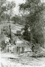 Ringwood and District Historical Society
Photographs, 1979-80 MMBW pipe line project at Hubbard Reserve, North Ringwood � Tracked drill rig
Part of a 43-photo record of the MMBW�s engineering feat in drilling a 12 inch pipe line up to 40 feet deep through rock hardened by volcanic action associated with geological fault that occurs along the line. The work took place from October 1979 to May 1980 on the southern boundary of Hubbard Reserve, North Ringwood. The collection was presented to the Ringwood Historical Research Group by J Clarke on 9th June 1980.E561 N16 3 March 1980 A43 Tracked drill rig on the line of trench for sewer to Debbie Place -
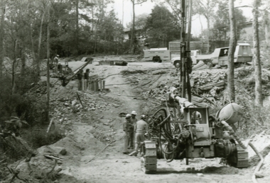
 Ringwood and District Historical Society
Photographs, 1979-80 MMBW pipe line project at Hubbard Reserve, North Ringwood � Air track drill rig
Part of a 43-photo record of the MMBW�s engineering feat in drilling a 12 inch pipe line up to 40 feet deep through rock hardened by volcanic action associated with geological fault that occurs along the line. The work took place from October 1979 to May 1980 on the southern boundary of Hubbard Reserve, North Ringwood. The collection was presented to the Ringwood Historical Research Group by J Clarke on 9th June 1980.E561 N19 3 March 1980 A43 Air track drill rig in position as in N18 -
 Ringwood and District Historical Society
Photographs, 1979-80 MMBW pipe line project at Hubbard Reserve, North Ringwood � Last days of the boring
Part of a 43-photo record of the MMBW�s engineering feat in drilling a 12 inch pipe line up to 40 feet deep through rock hardened by volcanic action associated with geological fault that occurs along the line. The work took place from October 1979 to May 1980 on the southern boundary of Hubbard Reserve, North Ringwood. The collection was presented to the Ringwood Historical Research Group by J Clarke on 9th June 1980.E561 N1 1 April 1980 A43 Last days of the boring. The mole had broken between the last two shafts. Dominic Di Nezza and Glen Pearson discuss further moves to release it. -
 Ringwood and District Historical Society
Photographs, 1979-80 MMBW pipe line project at Hubbard Reserve, North Ringwood � Drill rig
Part of a 43-photo record of the MMBW�s engineering feat in drilling a 12 inch pipe line up to 40 feet deep through rock hardened by volcanic action associated with geological fault that occurs along the line. The work took place from October 1979 to May 1980 on the southern boundary of Hubbard Reserve, North Ringwood. The collection was presented to the Ringwood Historical Research Group by J Clarke on 9th June 1980.E561 N17 3 March 1980 A43 Powder-monkey marks out the spots for holes -
 Ringwood and District Historical Society
Photographs, 1979-80 MMBW pipe line project at Hubbard Reserve, North Ringwood � View towards Debbie Place
Part of a 43-photo record of the MMBW�s engineering feat in drilling a 12 inch pipe line up to 40 feet deep through rock hardened by volcanic action associated with geological fault that occurs along the line. The work took place from October 1979 to May 1980 on the southern boundary of Hubbard Reserve, North Ringwood. The collection was presented to the Ringwood Historical Research Group by J Clarke on 9th June 1980.E561 N15 3 March 1980 A43 View towards Debbie Place, showing 2 swivel cranes at shafts, timber of manhole in creek, the tracked drill rig and its compressor caravan. -
 Ringwood and District Historical Society
Photographs, 1979-80 MMBW pipe line project at Hubbard Reserve, North Ringwood � Boring mole pit
Part of a 43-photo record of the MMBW�s engineering feat in drilling a 12 inch pipe line up to 40 feet deep through rock hardened by volcanic action associated with geological fault that occurs along the line. The work took place from October 1979 to May 1980 on the southern boundary of Hubbard Reserve, North Ringwood. The collection was presented to the Ringwood Historical Research Group by J Clarke on 9th June 1980.E561 N14 3 March 1980 A43 View west behind No. 29 Burlock Avenue, showing gantry over manhole 38 feet deep. -
 Ringwood and District Historical Society
Photographs, 1979-80 MMBW pipe line project at Hubbard Reserve, North Ringwood � The work on sewer line from 29-39 Burlock Avenue
Part of a 43-photo record of the MMBW�s engineering feat in drilling a 12 inch pipe line up to 40 feet deep through rock hardened by volcanic action associated with geological fault that occurs along the line. The work took place from October 1979 to May 1980 on the southern boundary of Hubbard Reserve, North Ringwood. The collection was presented to the Ringwood Historical Research Group by J Clarke on 9th June 1980.E561 N11 3 March 1980 A43 The work on sewer line from 29-39 Burlock Avenue. Lundy-Clarke's place on sky-line. -
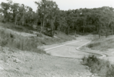
 Ringwood and District Historical Society
Photographs, 1979-80 MMBW pipe line project at Hubbard Reserve, North Ringwood � View from Debbie Place, preliminary sewer work
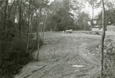
Part of a 43-photo record of the MMBW�s engineering feat in drilling a 12 inch pipe line up to 40 feet deep through rock hardened by volcanic action associated with geological fault that occurs along the line. The work took place from October 1979 to May 1980 on the southern boundary of Hubbard Reserve, North Ringwood. The collection was presented to the Ringwood Historical Research Group by J Clarke on 9th June 1980.E561 N13 28 Feb 1980 A43 View from Debbie Place, preliminary sewer work -
 Ringwood and District Historical Society
Photographs, 1979-80 MMBW pipe line project at Hubbard Reserve, North Ringwood � Line of tunnel shafts behind 29-39 Burlock Avenue
Part of a 43-photo record of the MMBW�s engineering feat in drilling a 12 inch pipe line up to 40 feet deep through rock hardened by volcanic action associated with geological fault that occurs along the line. The work took place from October 1979 to May 1980 on the southern boundary of Hubbard Reserve, North Ringwood. The collection was presented to the Ringwood Historical Research Group by J Clarke on 9th June 1980.E561 N10 Feb 1980 A43 Line of tunnel shafts behind 29-39 Burlock Avenue. Horizontal gantry was above the manhole in the corner of No. 29. -
 Ringwood and District Historical Society
Photographs, 1979-80 MMBW pipe line project at Hubbard Reserve, North Ringwood � First hole west of bore hole at 39 Burlock Avenue
Part of a 43-photo record of the MMBW�s engineering feat in drilling a 12 inch pipe line up to 40 feet deep through rock hardened by volcanic action associated with geological fault that occurs along the line. The work took place from October 1979 to May 1980 on the southern boundary of Hubbard Reserve, North Ringwood. The collection was presented to the Ringwood Historical Research Group by J Clarke on 9th June 1980.E561 N9 Feb 1980 A43 First hole west of bore hole at 39 Burlock Avenue -
 Port Melbourne Historical & Preservation Society
Mixed media, History of a Street Precinct
A cultural grant was given to Margaret BRIDE to implement this study, which she did with the help of her husband Graham and several residents of the study area including PMH&PS members Emily LOCK, David THOMPSON, Jack BOLT and Kerrie MATHEE.History of a Street Precinct, documenting 80 years plus of the history of the area bounded by Williamstown Road and Evans, Bridge and Farrell Streets, since 1880. One of two products of a 2005 project (which subsequently won the 2007 Victorian Local History Awards for research). An interactive CD containing information and photographs. This was packaged with a brochure (2148.01) containing a map of the area and photos and information on key properties and individuals on 91 buildings and their occupants over time.built environment -
Port Melbourne Historical & Preservation Society
Poster, History of a Street Precinct
A cultural grant was given to Margaret BRIDE to implement this study, which she did with the help of her husband Graham and several residents of the study area including PMH&PS members Emily LOCK, David THOMPSON, Jack BOLT and Kerrie MATHEE.History of a Street Precinct, documenting 80 years plus of the history of the area bounded by Williamstown Road and Evans, Bridge and Farrell Streets, since 1880. One of two products of a 2005 project (which subsequently won the 2007 Victorian Local History Award for research). A brochure containing a map of the area and photos and information on key properties. An interactive CD (2148.02) containing information and photographs on 91 buildings and their occupants over time was also produced. built environment -
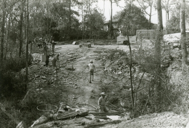
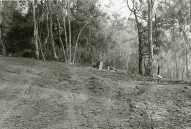
 Ringwood and District Historical Society
Photograph, 1979-80 MMBW pipe line project at Hubbard Reserve, North Ringwood. Debbie Place from the east end
Part of a 43-photo record of the MMBW's engineering feat in drilling a 12 inch pipe line up to 40 feet deep through rock hardened by volcanic action associated with geological fault that occurs along the line. The work took place from October 1979 to May 1980 on the southern boundary of Hubbard Reserve, North Ringwood. The collection was presented to the Ringwood Historical Research Group by J Clarke on 9th June 1980.E550 N12 Dec 1979 A43 Debbie Place from the east end -
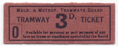 Melbourne Tram Museum
Ephemera - Ticket, Melbourne & Metropolitan Tramways Board (MMTB), strip of MMTB 3d tickets, 1930's
Single or one off of a pre purchased or prepaid ticket one of a strip of MMTB 3d tickets with an "O" in the bottom left hand corner of both sides. Check ticket required to be issued with a fare. Red cardboard. Has the full name of the MMTB one side and "M&MTB" on the other side. See Reg Items 1152, 2487 and 3341 for similar tickets of other values. See Reg Item 5854 for a set of research notes.trams, tramways, tickets, mmtb, pre-paid tickets -
Bendigo Historical Society Inc.
Document - RESEARCH FOLDER COLLECTION: BURKE AND WILLS MONUMENT, 1990 - 2015
Folder of research material compiled by Carol Holsworth. Received at History House in July 2023. Burke and Wills Monument A folder of material relating to the Burke and Wills monument at the Bendigo cemetery including photographs and historical information, The folder also contains information about the Burke and Wills expedition that Carol collected over many years. This material was presented to the Bendigo Historical Society in 2010 after the commemoration events marking the 150th Anniversary Celebration that year.Carol Holsworthbendigo, history, burke and wills monument -
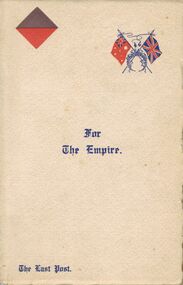 Bendigo Historical Society Inc.
Book - LYDIA CHANCELLOR COLLECTION: 'FOR THE EMPIRE. THE LAST POST. MAJOR MURDOCH NISH MACKAY LLM.'
Two copies of a white soft covered book titled, 'For The Empire. The Last Post.' On the inside front cover are the words, ' Major Murdoch Nish Mackay, LLM. Scholar and Patriot.' Forward by G. Mackay the father of Murdoch. One copy has some personal signatures. Cambridge Press, Bendigo. C.1917. 44 pgs. [photos]. In recent years someone has researched Mackay and the printed sheets have been included here.Cambridge Press, Bendigo. C.1917.person, world war 1, major murdoch nish mackay, lydia chancellor, collection, world war 1, world war 1 personal accounts, memorials, major murdoch nish mackay llm., soldiers, war, male, person -
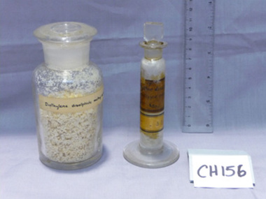 University of Melbourne, School of Chemistry
Diethylene Disulphide Methyl Iodide
Born in Ireland, John Drummond Kirkland trained as a chemical analyst through apprenticeship in a medical laboratory in Dublin, before migrating to Australia in 1852 and moving to Melbourne in 1855. While still an undergraduate medical student at the University of Melbourne, he was appointed lecturer in chemistry following the sudden death of John Macadam in 1865. Due to the enthusiastic support of his fellow students this temporary role became a permanent appointment the following year. Kirkland continued his studies, graduating in medicine in 1873 and surgery in 1880. His son, John Booth Kirkland, was appointed as his assistant in 1878, later leading to accusations of nepotism. In 1882 John Drummond Kirkland became the University?s first professor of chemistry and metallurgy, continuing until his death in 1885. Today?s researchers use a high performance computing facility named ?Kirkland? after the first Professor of Chemistry at the University of Melbourne. Chemistry was still controlled by the medical school during Kirkland?s career, but became part of the science degree from 1886, along with the appointment of David Orme Masson as professor. Kirkland struggled for University funding to buy new apparatus. To compensate, he bought much from his own personal funds, including analytical chemistry equipment. Chemistry was first taught at Melbourne in the medical school, located in the area now occupied by Physics and the Ian Potter Museum of Art. (Sir) David Orme Masson was Professor of Chemistry at the University of Melbourne from 1886 to1923. As well as being a distinguished teacher and researcher, he contributed significantly to Australian scientific and public life, being instrumental in the establishment and governance of many important bodies including the CSIRO. Masson supported Antarctic research for 25 years, beginning with Douglas Mawson?s expedition of 1911. Born in England and receiving an MA, BSc and DSc from the University of Edinburgh, he was a gifted, elegant and disciplined lecturer and a researcher of substance. His research work included the theory of solutions, from which emerged the term ?critical solution temperature?; the periodic classification of the elements; and the velocity of migration of ions in solutions. Much of his research was done in collaboration with talented students such as David Rivett and his own son Irvine Masson. Masson was knighted in 1923. He is commemorated by the Masson Theatre and Masson Road at the University of Melbourne; a mountain range and island in Antarctica; a portrait painting by William McInnes in the foyer of the School of Chemistry; the Masson lectureship from the Australian National Research Council; and the Masson memorial scholarship from the Royal Australian Chemical Institute.Stocks used in the Blackie - Masson - J.B.Kirkland work.