Showing 23746 items
matching sardine-creek
-
 Bendigo Military Museum
Book - BOOK DEMOBILIZATION, Demobilization procedure, Issued 9 Oct 1945
C.W Curnow. Refer Cat No 1444, 1445.2, 1446.2.Demobilization procedure book, AAB87, No 373082 re C.W Curnow."VX100151, L/Cpl Curnow, Clarence Wilfred, Campbells Creek Vic"documents, demobilization, curnow -
 Greensborough Historical Society
Aerial Photograph, Flintoff land - View from above, 1945_
Section of the 1945 Greensborough aerial survey, focusing on the land belonging to the Flintoff familyPhotocopy of section of 1945 aerial survey of Greensborough area"Flintoff land to west of Diamond Creek Rd" written in pencil on backflintoff family, aerial photograph -
 Falls Creek Historical Society
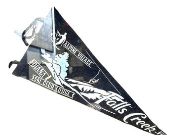
Memorabilia - Diana Ski Lodge Banner, 1960s
Diana Lodge was built and operated by Kevin Shoebridge as a family lodge in the 1950s and it has grown and evolved over 60 years to become Diana Alpine Lodge. After Mr Shoebridge moved to Wodonga he leased Diana Lodge to Bob Scott and it also became the Post Office and Telephone Exchange. From early 1967 until about 1975, Diana Lodge was owned and operated by John and Gwyn van Burck. It was then purchased by a group of 12 families operating as Swan Hill Alpine Holdings. Diana Alpine Lodge has operated under several owners and was sold again as recently as 2023. This pennant was used in the early 1960s as a souvenir to promote Diana Lodge.This item is significant because it promotes Diana Lodge, a long standing accommodation venue at Falls Creek.A black and white triangular banner including an image of a skier and a second person on a chair lift.ALPINE VILLAGE DIANA SKI CLUB LODGE FALLS CREEK, VICdiana alpine lodge, falls creek accommodation -
 Bendigo Historical Society Inc.
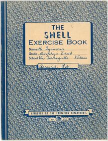
Document - M. Symons' Murpheys Creek Exercise Book
Land was first selected at Murphy's Flat in 1865. The first Wesleyan church was built in 1866 and from 1869 this was used as State School 149. A purpose built school, No. 1311 opened mid 1876. The areas name was changed to Murphy's Creek in 1915.A blue and white exercise book. Attached within are various subscription receipts in the front and back, including the "Australian Home Journal," "Singer Sewing Machine Company," and an "Annual Audit of Depositors' Pass-books by the State Savings Bank of Australia. Also included in approximately half the book are handwritten record of correspondence notes in blue ink, many regarding sewing from 1949-1956.The Shell Exercise Book. Name: M. Symons (Handwritten Blue Ink). Grade: Murphys Creek. School: Via, Tarnagulla, Victoria (Handwritten Blue Ink). Receipts, Etc.(Handwritten Blue Ink), Approved by the Education Department. Shell Series. On the back is printed Arithmetic Tables and a Multiplication Tableexercise book, receipts, tarnagulla -
 Falls Creek Historical Society
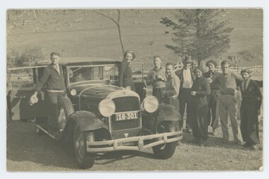
Photograph - Fitgerald's Hut to Shannonvale, 1937
MEYER COLLECTION - FALLS CREEK PHOTOS In 1947 a determined group of like-minded State Electricity Commission (SEC) staff including Ray Meyer, the chief surveyor of the Kiewa Hydro-Electric Scheme, had a common interest that revolved around the skiing potential of the snow-covered high plains which included what is now the resort of Falls Creek. The six SEC employees, Toni St Elmo, Ray Meyer, Jack Minogue, Lloyd Dunn, Adrian Ruffenacht and Dave Gibson (together with their families) banded together to secretly build a 'hut' that was the first ski lodge at Falls Creek. Using a road built in 1930s to gain access to Falls Creek, their hut project was carried out in secret as efforts by other skiers were blocked by H.H.C. Williams – the engineer in charge of the Hydro Scheme. In 1946 Ray Meyer made a trip to the Lands Office in Melbourne. He came away with a 99-year lease on three acres that was ideally suited for a hut designed by Lloyd Dunn. Adrian Ruffenacht (Design Engineer for the KHS) had suggested where the group should build because of easy access to a spring for water. Much of the building material required was scavenged from derelict huts on the high plains. Due to the need for secrecy, the determined group worked on the hut in the evenings and weekends to avoid detection. During the building period the group had met at Echidna Rock (now known as Eagle Rock) where Skippy St Elmo announced, "This is my favourite ‘Skyline’.” And so the first lodge in the area at Falls Creek Ski Resort came into existence. With the development of the International Poma in the 1970s, the Skyline Lodge, which was sited between the ski-lift’s pole one and pole two, was demolished. However, the legacy of Ray Meyer, Toni St Elmo, Jack Minogue, Lloyd Dunn, Adrian Ruffenacht and Dave Gibson and Skyline lives on in the vibrant atmosphere of Falls Creek Resort. The MEYER COLLECTION documents developments on the Kiewa Hydro Scheme and their life at Falls Creek from the mid 1930s to 1960s.These images are significant because they depict aspects of the life of a pioneering family of Falls Creek and the founders of "Skyline", the first lodge at Falls Creek.A collection of photos related to a sledge trip between Fitzgeralds Hut and Shannonvale in September 1937. 1. L - R:- Cyril Louder, Eileen McEvoy, Bill Burrows (?), Dad Fitzgerald, Olive Sandell (standing in front of Marie Hatters) 2. Little Jimmy Wheeler 3. Fitz's Hut - leaving for Shannonvale 4. Looking down Middle Creek valley from SEC Camp Bogong High Plains 5. Tom Fitzgerald has a nap at Fitz's Hutfalls creek, fitzgerald hut, shannonvale, sledge party 1937 -
 Tarnagulla History Archive
Telegram, circa 1862
A large lot of papers, including this and other telegrams, were apparently found in the ceiling cavity of the Sandy Creek/Tarnagulla Post and Telegraph Office in the later 20th Century, during building works. Donald Clark Collection. Telegram sent from Sandy Creek / Tarnagulla Telegraph Office. From John Papineau (on behalf of E.N. Francis) to Mrs Giradini, Sandhurst. Text reads 'Your brother and his mate bought a horse at Cochrane's Diggings which had been stolen and the police found it in their possession. They are innocent but I have to bring witnesses a long distance. I shall defend them in expectation of securing the five pounds from you'. -
Bendigo Historical Society Inc.
Photograph - POSTCARD - ANTICLINE ON BENDIGO CREEK
Postcard: anticline on Bendigo Creek. Sepia print on postcard. Anticline in centre of photo. Paling fence extends along entire back of photo. Behind fence small weatherboard building ( outhouse ? )Written on back in pencil ' anticline in creek at Golden Square, area of old bridge over Bgo creek' Stamped in blue ' Bendigo Institute of Technology, Geology Dept. 'place, gold, bendigo creek, bendigo, gold, anticline, bendigo creek, discovery of gold in bendigo -
Bendigo Historical Society Inc.
Map - CAMPBELL COLLECTION: BENDIGO AND DISTRICT MAPS
Map. Lockwood, Parishes of Lockwood and Shelbourne, scale 20 chains to 1 inch. Spring Creek centre of map and Bullock Creek to the right. Total area 4405 acres. (number 358 in map cupboard 1)map, bendigo, allotments -
Bendigo Historical Society Inc.
Drawing - HARRIS COLLECTION: CHARCOAL SKETCH OF CREEK AND HUT
Charcoal sketch on cream background of creek, small hut on bank, eucalypts on LH side and in background. Most probably a depiction of the Harris orchard/vineyard on Axe Creek, Axedale, near the bridge on the Mt. Sugarloaf Road.George Harris, Axedaleartwork -
 Falls Creek Historical Society
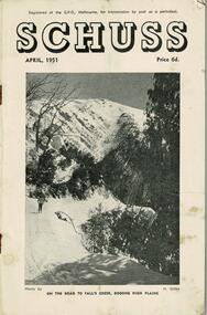
Journal - Schuss Vol. 17. No. 4 April 1951
Schuss was advertised as Victoria’s Official Ski Journal It was issued monthly from 1935 to 1961 except during the war when summer issues covered two months. This continued after the war, but it averaged 10 issues annually over its 25 year life. Schuss was published by the Ski Club of Victoria which had a membership of 38 Ski Clubs and demanded to be recognised as the prime authority on skiing in the state. The other 30 ski clubs with 85% of the members disagreed and the politics of skiing became heated. These clubs formed the Federation of Victorian Ski Clubs with their own journal, Ski Horizon. With the establishment of the Victorian Ski Association, Ski-Horizon published its last issue in Nov - Dec. 1955 and the role of the official journal was fully taken over by “Schuss”. This item is significant because it contains stories, images and information documenting the development of the ski industry in Victoria.The journal features stories and events chronicling developments in Victoria and internationally. Items related to the Falls Creek Area in this issue include:- Cover - Features a photo by H.Gibbs titled "On the road to Falls Creek, Bogong High Plains"schuss journal, the ski club of victoria -
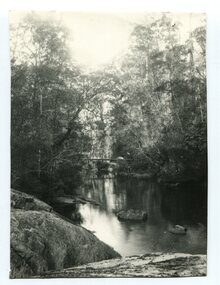 Orbost & District Historical Society
black and white photograph
A black / white photograph of a bush scene with a creek and what might be a bridge in background.creek river bush-scene -
Glenelg Shire Council Cultural Collection
Negative, c. 1936
Transparency for black and white photo. Portland Botanic Gardens, Salt Creek in foreground -
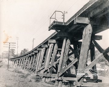 Eltham District Historical Society Inc
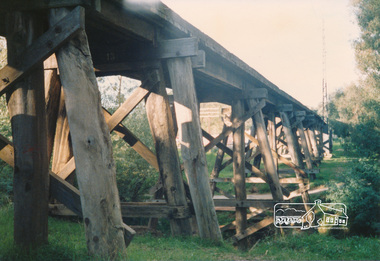
Photograph, George W. Bell, Trestle Bridge, Eltham, 1960c
Black and white photograph of Railway Bridge over Diamond Creek c.1960railways, bridges, eltham, diamond creek, george w bell collection -
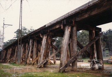 Eltham District Historical Society Inc
Photograph, Railway trestle bridge, Panther Parade, Eltham, July 1986, Jul-86
Two colour photographs of railway trestle bridge over Diamond Creek, Elthamrailways, diamond creek, panther place, bridges, eltham -
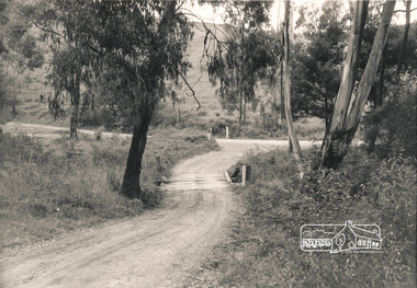 Eltham District Historical Society Inc
Photograph, Mittons Bridge, 1972c
Black and white photograph of Mittons Bridge over Diamond Creek c.1972bridges, mittons bridges, diamond creek, st andrews -
 Eltham District Historical Society Inc
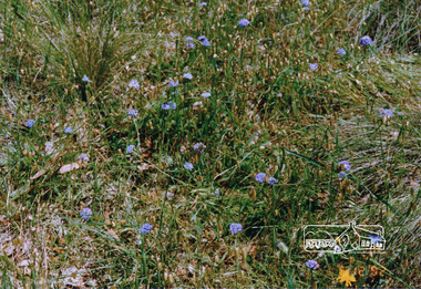
Photograph, Russell Yeoman, Blue pincushions, St Andrews
Colour photograph of blue pincushions, Wild Dog Creek Road, St Andrewspincushions, brunonia australis, st andrews, wild dog creek road, wildflowers -
 Eltham District Historical Society Inc
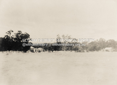
Photograph, North Eltham floods, 1924, 1924
Colour photograph of original showing Diamond Creek in flood at north Eltham 1924floods, diamond creek, eltham, north eltham -
 Eltham District Historical Society Inc
Photograph, Railway trestle bridge Eltham
Two colour photographs of railway trestle bridge over Diamond Creek, Elthambridges, railways, eltham, diamond creek, panther place -
 Bendigo Historical Society Inc.
Map - JACK FLYNN COLLECTION: VILLAGE OF BETLEY, 30/06/1874
Map: Village of Betley, on the Bet Bet Creek, Parish of Dunolly. Parish plan.Photo Lithographed at the Department of Lands and Survey Melbourne by J. Noone 30.6.74map, gladstone, village, betley, bet bet creek, dunolly -
 Stawell Historical Society Inc
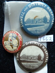
Memorabilia - Badge
Pre 1930's Stawell Pleasant Creek Hospital Fundraising Badges. (4)stawell -
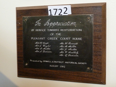 Stawell Historical Society Inc
Plaque, 30164
Plaque - In Appreciation of P/Creek C/H Restoration. Stawell Historical Societystawell -
 Clunes Museum
Photograph
COLOUR PHOTOGRAPH CLEARING ALONG CLUNES CREEK, BLACKMORE ROAD BELOW THE FORDlocal history, photography, photographs, clunes landscape -
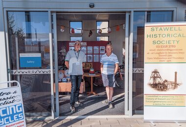 Stawell Historical Society Inc
Photograph, Bicycle Display at Stawell Historical Society c2019, 2019
David Francis & Greg Robson in front of Bicycle display set up by David a Member of Stawell Historical SocietyGreg Robson & david Francis in doorway of Pleasant Creek historic Precinct Gallerysports -
Whitehorse Historical Society Inc.
Article, Joy at Mullum Mullum wildlife finds, 2005
Article on echidna sighting near Mullum Mullum Creek. With photo of Betty Millner.Article on echidna sighting near Mullum Mullum Creek. With photo of Betty Millner.Article on echidna sighting near Mullum Mullum Creek. With photo of Betty Millner.millner, betty, mullum mullum creek, echidnas -
Whitehorse Historical Society Inc.
Map, City of Whitehorse, 1/03/1995 12:00:00 AM
Map of City of Whitehorse prepared by Richard Meloni showing roads, railways, creeks.Map of City of Whitehorse prepared by Richard Meloni showing roads, railways, creeks.Map of City of Whitehorse prepared by Richard Meloni showing roads, railways, creeks.blackburn, nunawading, blackburn south, mitcham, vermont, vermont south, blackburn north, forest hill, burwood east, city of whitehorse -
 Whitehorse Historical Society Inc.
Photograph, Bridgeworks - Mitcham
Coloured photograph of bridgeworks taking place along Deep Creek Road, Mitchamdeep creek road, mitcham -
 Whitehorse Historical Society Inc.
Photograph, Yarran Dheran
Coloured photo of Bushland along Walk in Yarran Dheran. Mullum Mullum Creek.yarran dheran, mullum mullum creek -
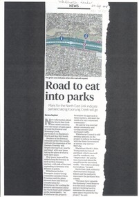 Whitehorse Historical Society Inc.
Article, Road to Eat Into Parks, 2018
Plans for the North East Link indicate parkland along Koonung Creek will go.Plans for the North East Link indicate parkland along Koonung Creek will go.Plans for the North East Link indicate parkland along Koonung Creek will go.north east link, koonung creek, blackburn north, eastern freeway, whitehorse active transport action group, city of whitehorse, bicycle paths -
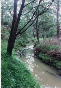
 Whitehorse Historical Society Inc.
Photograph, Yarran Dheran
Black and white photo of Mullum Mullum Creek at Yarran Dheran in Freeway reserve.mullum mullum creek, yarran dheran -
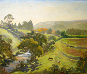 Brimbank City Council Art Collection
Painting, Maribyrnong River from Horseshoe Bend Road, Keilor, 1977
Local SceneImpressionistic view of valley with a creek running through it. Three horses in the foreground - AR0064Information about the artist on the back. "James Farrell is a member of the Victorian Artists Society" and "is represented at the Australian War Memorial, Canberra".keilor, maribyrnong, river, painting, impressionist, landscape