Showing 8501 items
matching snowy-river-dry-cleaners
-
 Glenelg Shire Council Cultural Collection
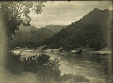
Negative - Negative - Nelson, Victoria, c. 1936
Transparency for black and white photo. Panoramic view of Nelson, Vic, looking towards river mouth -
Glenelg Shire Council Cultural Collection
Postcard - Postcard - Suspension bridge Casterton, 1900-1930
SOURCED FROM CASTERTON TOWN HALL (FORMER SHIRE OF GLENELG) Sourced from Casterton Town Hall (Former Shire of Glenelg)Postcard, black and white,, showing the suspension bridge at Casterton, view across river towards townshipFront: 'SUSPN BRIDGE CASTERTON' Back: Handwritten correspondence, addressed to 'Miss M. Sythaleigh, Henty St Casterton' -
 Federation University Historical Collection
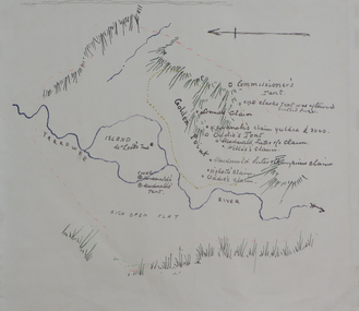
Plan, Dunn's Map of Early Gold Diggers at Golden Point, Ballarat, not dated
Hand drawn map in colour showing Yarrowee River and claims including James Oddie and Highett.dunn, dunn's map, comissioner's tent, oddie's claim, highett's claim, macdonald, suter & co claim, james oddie, golden point, gold discovery -
 Bendigo Historical Society Inc.
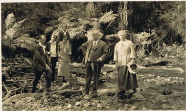
Photograph - BLACK AND WHITE PHOTOGRAPH: TAGGERTY RIVER MARYSVILLE 1924-5
black and white photograph - Family and friends at Taggerty River Marysville 1924-5. Marysville Victoria.photograph, person, male / female, taggerty river marysville 1924-5 -
Port Melbourne Historical & Preservation Society
Photograph - Westgate Park, David Thompson, c. 1994
Eleven colour photographs of Westgate Park and birdlife, bank of Yarra River skirting the park, and the Puntbuilt environment - civic -
 Port Melbourne Historical & Preservation Society
Photograph - Wangaratta, Yarra River, Roy Liebig, 1945
The donor's (Karen Bowden) grandfather - Roy Liebig (1897-1968) - took these photos in the 1940s. Karen, as administrtor of his estate, has extracted various photos and sent them to appropriate historical societies.A series of photographs taken by Roy Liebig in the 1940s Hard copy and digital. "Nairana" Yarra Rivermaritime, piers and wharves, war - world war ii, roy liebig, karen bowden, yarra river, nairana -
Port Melbourne Historical & Preservation Society
Map - City of South Melbourne, 1854 - 1884
Detailed map of City of South Melbourne. Date uncertain. Shows early configuration of river and docks."South Melbourne, Sheet 2"emerald hill, town planning -
Port Melbourne Historical & Preservation Society
Map - Chart, Hobson's Bay, river and navigational aids, 1839 - 1843
On back is handwritten note - Hobson's Bay pp from HMS Beagle 1838-43.Map (Chart) of Hobson's Bay, River and Navigational Aids 1839. (Latrobe Library). in photographic form.melbourne harbor trust - port of melbourne authority, hobson's bay -
 Bendigo Historical Society Inc.
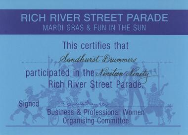
Document - SANDHURST DRUMMERS COLLECTION: CERTIFICATE, 1990
Documents. Blue Participation Certificate for Sandhurst Drummers from Rich River Street Parade 1990.document, memo, participation certificate -
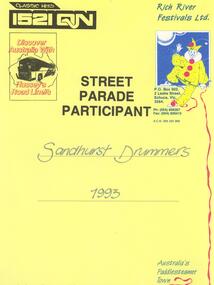 Bendigo Historical Society Inc.
Document - SANDHURST DRUMMERS COLLECTION: CERTIFICATE, 1993
Document. Certificate awarded to Sandhurst Drummers Street Parade Participant 1993 Rich River Festival.document, memo, certificate. -
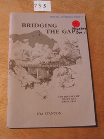 Stawell Historical Society Inc
Book, Ida Stanton, Bridging The Gap 1988 -- The History of Halls Gap From 1840 by Ida Stanton, 1988
Tales of Hall's Gap in the Grampians, as collected by the Pupils of Hall's Gap Primary School, from the descendants of Pioneer Families, and Recorded prior to 1940. Rerecorded from old well worn notes, by Grant W Greenwood, Head Teacher 1937-1939.Fawn cover with drawing of trees and mountain in the background. in the foreground is a bridge over a river, with a woman in a dray. Presented to Stawell Historical Society Ida Stanton May 1989stawell grampians -
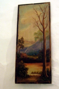 Whitehorse Historical Society Inc.
Painting - Panel Painting
In the early 1920s Reginald and Gladys Skelton rented Schwerkolt Cottage. When they left to live in their new home on Deep Creek Road, having been encouraged by Mrs. Louis Schwerkolt to purchase the block, they where given this painting which was on a panel on the door of the eastern room. When the Nunawading Council was refurbishing the Cottage in 1964, Mr Skelton returned the panel. This information was provided by Lyn Davies the daughter - in - law of Mr. and Mrs. Skelton.Painting depicting a rural scene with a river and a bared tree in the foreground and a house, fields and hills in the background.illustrations, oil -
 Rutherglen Historical Society
Photograph - Image, The Argus
Girl Guide troop shown is probably one led by Florence Iggsten.Black and white photograph of a group of Girl Guides on an excursion next to a river. Some of them are in a boat.On back of photo: a rubber stamp saying "Please acknowledge 'The Argus', Melbourne Australia. Copyright Photograph. Negative No. E149 Reference No. ____"girl guides, camping -
 Kew Historical Society Inc
Photograph - Zig-zag Bridge on the Yarra River at Kew, Henry Beater Christian, 1920-28
Henry Christian (c.1809-91), the grandfather of the photographer, was one of the first settlers in Kew. He arrived in Victoria with his wife Agnes and son Orlando in 1855 on the Gypsy Queen. He established a rope-making business in Bulleen Road by 1858 but was declared insolvent two years later. In his final years, he was celebrated as one of the oldest living settlers of the district. His son, Orlando Henry Beater Christian (c.1853-1930) became a member of the Hawthorn Band and a foundation member of the Willsmere Swimming Club. Orlando and his wife Elizabeth had four children of which Henry Beater Christian (1886-1962) was the eldest.Small black and white photograph of the Zig-zag Bridge over the Yarra River at Studley Park.henry christian (1886-1962), landscape photography, yarra river -- studley park -- kew (vic.), zig-zag bridge -- yarra river -- kew (vic.), christian-washfold collection -
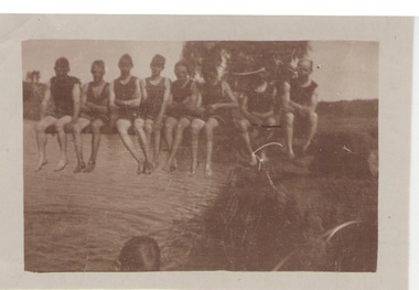 Sunbury Family History and Heritage Society Inc.
Photograph, c1920s
The swimmers were seated on the diving board over Jacksons Creek at The Nook, which served as a swimming pool in Sunbury until 1966 when the long-awaited for swimming pool was officially opened in Ligar Street on19th January 1966. For a number of years before the official opening townspeople organised many fund raising events to pay for the new pool. The pool at The Nook served as a popular swimming place for many years in Sunbury during the summer weather.A sepia photograph with a white border of a group of eight swimmers sitting on a diving board over a river. swimming, the nook, swimming clubs -
Montsalvat
Photograph, Untitled (Indigenous Man), 1960
Black and white photograph of an indigenous man seated on the river bank with his image reflected in the water. Signed in pencil (Ll) '1/10' (Lc) 'Matcham Skipper' and dated (Lr) 'circa 1960' on matt boardmatcham skipper, photograph, indigenous, male -
 Port Fairy Historical Society Museum and Archives
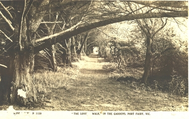
Postcard - Post Card, The Rose Series / The Rose Stereographs, The Lovers Walk in the Gardens, Port Fairy
The Port Fairy Botanical Gardens were formed in 1856 making it one of the earliest gardens in Victoria. The first curator was James Prior, he was paid fifty-two pounds per annum. He was an outstanding curator having been apprenticed to the trade in England at the age of 12, his brother Edward in later years was the Curator of the Koroit Gardens. Prior retired in 1903. During the years of his curatorship Port Fairy was said to have the best gardens outside the city of Melbourne, he was constantly in touch with Baron Von Mueller and later Guilfoyle of the Royal Botanical Gardens of Melbourne. In the early years plants from all over the world were planted here with varying rates of success many of them sent by Baron Von Mueller. In the 1930’ and 40’s the gardens were still very beautiful, and the curator was Roy Manuell. The beautiful iron gates at the entrance were destroyed in the 1946 floods and were replaced in 1989 using some of the material from the original gates. From the 1950’s on the gardens went into a state of decline, much being taken up by the caravan park until in 1986, after a public meeting ‘Friends of the Gardens’ was founded when the entrance section was restored. Black and white Photograph of the path running along the river side of the gardens with trees overhanging the walkThe Rose Series P 1139 The Lovers Walk in the Gardens, Port Fairy, Vic.lovers walk - gardens, path, botanical, trees -
Tarnagulla History Archive
Postcard - Photographic postcard: Loddon River, Newbridge near Tarnagulla, c. 1900-1920s
Williams Family Collection. Monochrome photographic postcard, Reids Series No.5. Front image depicting the Loddon River at Newbridge. tarnagulla -
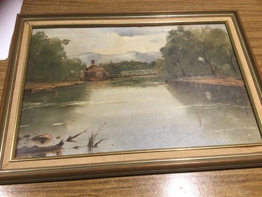 Mont De Lancey
Painting
Hand painted by Margaret Quayle.Original painting of Heidelberg, Victoria by Margaret Quayle. River scene with house and bridge, in a wooden frame.paintings, artworks -
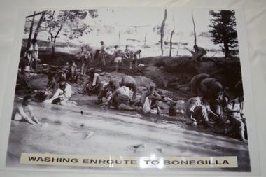 Wangaratta RSL Sub Branch
Photograph, c1940
In July 1940, the 2/24th Battalion was formed in Wangaratta. On the 27th September, after weeks of hard training the Battalion marched out to Bonegilla to continue training prior to overseas deployment to the Middle East in November, 1940. This image depicts soldiers bathing and washing during the 60 mile march.The 2/24th Battalion was an infantry battalion of the Australian Army, which served during World War II .A unit of all-volunteers, it was formed in July 1940 from primarily Victorian volunteers and was known as "Wangaratta's Own" because of the time the battalion spent in the town during its formative period prior to deployment overseas. It served in North Africa in 1941–1942 as part of the 26th Brigade, which was assigned to the 7th Division, before being reassigned to the 9th Division. In early 1943, the battalion returned to Australia and later took part in campaigns against the Japanese in New Guinea in 1943–1944 and Borneo in 1945, before being disbanded in 1946. The 2/24th suffered the highest number of casualties of any 2nd AIF infantry battalion. The Unit was granted the Freedom of the City by the Rural City of Wangaratta in 1990 and one of the first, if not the first, to receive this type of honour.Reproduced black and white photograph of unknown soldiers bathing and sitting on a river bank in bush land. Washing enroute to Bonegilla2/24th battalion, wangaratta -
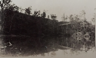
 Lakes Entrance Historical Society
Photograph - Derrick Ruins, Rev John Flynn, 1906
This is a photograph proof on light cardBlack and white photograph of view of Deddick River north of Buchan and old Deddick ruins VictoriaDeddick Ruins P36 Johyn Flynn Postcards from Buchan -
![Wal Ives & Bert [Watson] at the outlet of the Kew Main Drain](/media/collectors/550653872162f11fb04854aa/items/61593ef27608a87f688412b1/item-media/61594a5a7608a87f68848c29/item-fit-380x285.jpg) Kew Historical Society Inc
Kew Historical Society IncPhotograph - Wal Ives & Bert [Watson] at the outlet of the Kew Main Drain, c.1900
Connor's Creek is/was one of two major waterways bisecting Kew, both of which empty into the Yarra River. Connor's Creek originates near the grounds of Genazzano FCJ College, which is one of the highest points in Kew. Until the 1930s, this was an open creek until a barrel drain - the Kew Main Drain - was constructed. As the creek ran through Kew it cut across a number of roads the maintenance of which was a continuing concern for Kew Councillors. In August 1864, the Council called for tenders to erect a stone culvert and embankment over Connor's Creek, on Belford-road. This may be the embankment on which the boys are sitting.Original, small photographic positive on card of two boys, identified by the donor as 'Wal Ives and Bert' [Albert Watson] sitting on bluestone capping above an outlet of Connor's Creek. To the left of the boys is a barrel drain which at that stage was the outlet for Connor's Creek near the Yarra River. The retaining wall is constructed of brick. In ink on photo: "Wal & Bert"connors creek -- kew (vic), wal ives, albert watson, belford road, yarra river -- kew (vic.), creeks -- kew (vic.), drains -- kew (vic.) -
 Federation University Historical Collection
Book, Records of Meterological Data for Ballarat 1892-1897, 1892 - 1897
A summary of meteorological data appears in the Ballarat School of Mines Annual Report for 1887 (P.35, 50). The last such summary appears in the Ballarat School of Mines Calendar 1901-2 (p58), which contains the data for the year 1900. No references have been found re names and job duties/positions of data collectors. The data was recorded by J. Matsen and A. Kiedahl.A charcoal grey hard covered, 120 page ledger, with brown leather spine and corners. The ledger has 31 special column heading, with the observed data added by hand. The column headings are: (AM) Date, Barometer, Ther. of Bar., Wet Bulb., Dry Bulb, Maxim., Minim, Rainfall, Wind, Remarks and State of Weather (PM) Date, Barometer, Ther. of Bar., Wet Bulb., Dry Bulb, Maxim., Minim, Rainfall, Wind, Remarks and State of Weather.Gold lettering on spine "Meteorological Observations: and on a glued on leather patch "School of Mines Ballarat" also in gold lettering. Written on inside front page: "Elevation of barometer 1420ft above Sea Level. To reduce barometric readings to Sea Level When Thermometer stands at 40 add 1.606 (to barometer) 45 " 1.590 50 " 1.574 55 " 1.559 60 " 1.543 65 " 1.528 70 " 1.528 80 " 1.499 85 " 1.471 90 " 1.457 95 " 1.444 100 " 1.431 Lightly hand written in pencil on the next page: "J. Matsen Feb 1891 to Feb 1894 - 3 years A. Kildahl Feb 1894 - " A circle has been place around the hottest temperature for the month. ballarat school of mines, smb, meteorology, j. matsen, a. kiedahl, kiedahl, matsen, rain, weather, meteorological data -
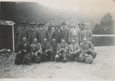 Lakes Entrance Historical Society
Photograph - Snowy Mountains Hydro Electric Scheme Alpine Country Victoria c1950, Jack Palmer, 1950 c
at a viewing point on their trip to the Snowy Mountains Hydro Electric Scheme Alpine Country VictoriaBlack and white photograph showing twenty members of Tambo Shire Council and staff . Seven other black and white photographs taken at same event 6 x 8.5 cm politics, local government, civil engineering -
 Kew Historical Society Inc
Photograph, J F C Farquhar, The Yarra in Hyde Park, 1891
At the beginning of the 1890s, the Kew businessman and Town Councillor, Henry Kellett, commissioned J.F.C. Farquhar to photograph scenes of Kew. These scenes included panoramas as well as pastoral scenes. The resulting set of twelve photographs was assembled in an album, Kew Where We Live, from which customers could select images for purchase.The preamble to the album describes that the photographs used the ‘argentic bromide’ process, now more commonly known as the gelatine silver process. This form of dry plate photography allowed for the negatives to be kept for weeks before processing, hence its value in landscape photography. The resulting images were considered to be finely grained and everlasting. Evidence of the success of Henry Kellett’s venture can be seen today, in that some of the photographs are held in national collections.It is believed that the Kew Historical Society’s copy of the Kellett album is unique and that the photographs in the book were the first copies taken from the original plates. It is the first and most important series of images produced about Kew. The individual images have proved essential in identifying buildings and places of heritage value in the district.Hyde Park is now a small recreation reserve bordered by Willsmere and Kilby Roads and White Avenue. In 1982, Hyde Park was cut off from the Yarra River by the construction of the Eastern Freeway. The building of the latter was to transform the natural landscape, including the Yarra, as well as Hyde Park. The construction of the Freeway makes it difficult to view the scene with the photographer’s eye. Today’s Hyde Park is located on land purchased in 1847 by John Cowell, and in 1851 Catherine Cowell, yet the scene selected by the photographer may well have been located on farmland owned by the Wills family. Farquhar’s point-of-view emphasises both the pastoral and recreational elements of the scene: the grazing cows, three boys, and in the distance two figures, seated on the bank with a parasol. By 1891, an environmental consequence of human activity, including farming, was deforestation, leading to the erosion of the south bank of the Yarra. In contrast, the land on the Alphington side of the river in 1891 included remnant bushland.The Yarra in Hyde Parkkew illustrated, kew where we live, photographic books, henry kellett, yarra river -
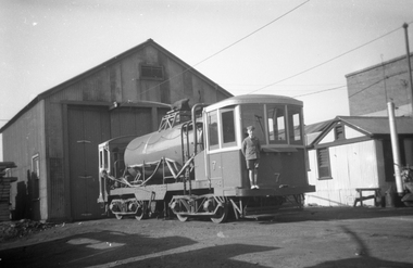 Melbourne Tram Museum
Negative, Jul. 1950
Black and white negative, by Wal Jack, of Track Cleaner No. 7 at the South Melbourne Depot, 1949 with a young boy standing on the bumper bar. See History for notes on the boy. Identical print on page 77 of the Wal Jack Melbourne 1st album and page 26 in the 2nd album.Ken Train on rear of photo in coloured pencil and 1949.trams, tramways, south melbourne depot, work trams, track cleaner, tram 7 -
Federation University Historical Collection
Equipment - Scientific Object, Test Tube Holder
This item was removed from the Mt Helen Campus S-Building before refurbishment in September 2015.A wooden test tube holder. It has cut circles in the structure to hold upright test tubes (those in use) and pieces of dowel to hold upside down test tubes (those in storage or drying). The word ananlite is engraved in the wood at the front. There are pen markings of numbers next to some of the holes and some of the pieces of dowel. The words water and lime are also written in pen, with arrows pointing towards, next to one of the end holes. test tube holder, test tubes, science, scientific equipment, laboratory -
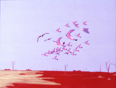 Nillumbik Shire Council
Collage (textile): Barbara MUNRO, Outback
collage; fabric on board. A flock of birds (galahs?) in colours of pink, purple and white fly above the dry barren (red) landscape. Low horizon line and vast open purple, blue sky. Signed lower right corner "Munro", not dated.fabric, collage, munro, textiles, outback -
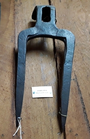 Mont De Lancey
Tool - Fork Hoe, Unknown
Used in the 19th Century. A forged steel two pronged Forked Hoe head used to break up very hard or dry ground. There is a bend at the top of the fork with a hole for the handle. It was made by a blacksmith and used in the 19th century.agricultural tools, gardening tools, steel, pitchforks -
 Wodonga & District Historical Society Inc
Functional object - Light 'N Easy Electric Iron, General Electric Housewares Pty Ltd, c1950s
From the late 1920s several brands of irons, including Hotpoint and Light' N Easy were manufactured in Australia by the Australian General Electric Co. Ltd. Light' N Easy irons were marketed as a versatile iron, small and light enough to be taken with you if you needed to travel away from home.This iron is representative of electrical appliances developed under licence in Australia from the late 1920s onwards.Small yellow steam iron. There are controls and a water level indicator on the side of the iron. There are 25 steam vents in the base. Steam and dry iron with surge of steam. A 3 metre electrical cord is attached.Label: " General Electric Housewares Pty Ltd. Vic/ Nottinghill Melbourne 3166/ 700 Watts/ APP NO. V79008 Cat 04/06 240 Voltsdomestic appliances, light 'easy irons