Showing 123982 items matching "main-road"
-
 Greensborough Historical Society
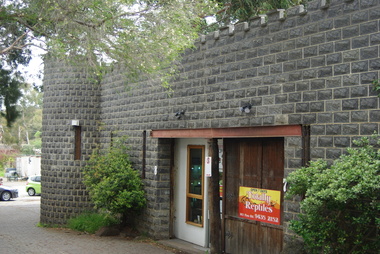
Photograph - Digital Image, Totally Reptiles, 183 Para Road, 06/11/2017
This photograph shows the exterior of the building at 183 Para Road when it was used for Totally Reptiles, who shared the building with Greensborough Grain Store.In 2017, the Greensborough Grain Store closed its Para Road premises and now trades online.Digital copy of colour photographgreensborough grain store, para road greensborough, totally reptiles -
 Stawell Historical Society Inc
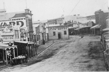
Photograph, Enlargement of Catalogue number 0541 of Main Street looking East featuring the Star Hotel, 1890's
Enlargement of right hand side of photo 0541. Top end of Main St. looking East towards Big Hill. From left Herbert Photographic, T Brown, Star Hotel on bend jutting out into middle of road. Mechanics Institute in background. Two Horse wagon in street on left.stawell businesses streetscape -
 Glen Eira Historical Society
Album - Album page, Myoora, 405 Alma Road, Circa 1972
This photograph is part of the Caulfield Historical Album 1972. This album was created in approximately 1972 as part of a project by the Caulfield Historical Society to assist in identifying buildings worthy of preservation. The album is related to a Survey the Caulfield Historical Society developed in collaboration with the National Trust of Australia (Victoria) and Caulfield City Council to identify historic buildings within the City of Caulfield that warranted the protection of a National Trust Classification. Principal photographer thought to be Trevor Hart, member of Caulfield Historical Society. Most photographs were taken between 1966-1972 with a small number of photographs being older and from unknown sources. All photographs are black and white except where stated, with 386 photographs over 198 pages.Victorian Heritage Register (VHR) Number H0490 From the Victorian Heritage Register Database - Citation for Myoora https://vhd.heritagecouncil.vic.gov.au/places/275 (as at 6/10/2020) Myoora, 405 Alma Road, North Caulfield, was designed by Reed, Henderson & Smart and can be attributed to Anketell Henderson. It was built in 1886 and 1887 for Thomas Christian, who had founded the fabled gold mine, the Day Dawn at Charters Towers. He never occupied the house although his widow lived there for some time. The house was subdivided into three and later six flats. Myoora was one of many large mansions on broad acres with gardens in Caulfield. Perhaps the grandest was Labassa. The mansions date from the 1850s through to the late 1890s. The siting of Myoora on a ridge influenced its planning and composition. A central hall and corridor along the ridge is entered from the centre of the more formal north facade. The entrance is marked by an elaborately detailed tower. A stair turret provides a second accent. The western end of the building is completed by a massively detailed chimney as the service wing. The south facade enjoyed an outlook to Port Phillip from a two-storey cast iron verandah. Bay windows, chimneys, the tower and the turret and minor details are brought together in a sophisticated asymmetrical composition. This is reflected in the planning. The asymmetry of Myoora pivoting on the tower is the most notable feature of the building. The walls are built of cement rendered brick. The cement render has not been painted. The roof is slate. The balconies and verandah are cast iron. The footings and cellar are bluestone. The architectural firm Reed, Henderson & Smart was very prominent in Victoria in the nineteenth century. Anketell Henderson was an eminent and well respected member of the profession. He worked successfully in London and interstate as well as in Victoria. They were better known for commercial and public buildings. Myoora is an important private commission. The style of Myoora is a combination of details from the Continental and English Renaissance through the boom style and the Queen Anne style. There is also an early influence from the American Romanesque style especially in the stair turret. The latter style was important at the turn of the century and Myoora is a significant precursor. Other buildings of a similar scale survive in Caulfield and elsewhere. Labassa, the most fabulous, is quite different stylistically as are most of the other comparable mansions. Stonnington is perhaps closer but relies on different details from the Queen Anne style and lacks any American influence. For its historical associations through its owners and architects, for its style and composition and for its intactness, Myoora is significant at a State level. The craftmanship of Myoora is what could be expected of a building of the time and type. It is relatively intact and in fair condition. The main staircase has been removed, minor alterations to decorative features have occurred and additions have been made to the exterior.Page 16 of Photograph Album including three black and white photographs. Two are arranged in landscape orientation on the right hand side of the page with the other photo in portrait mode on the left hand side. Handwritten: views from "Myoora" 405 Alma Road [top right] / Neg 181 Dec 1972 [under left side photo] / Neg 189 Dec 1972 [under bottom right photo] / 16 [bottom right]caulfield north, trevor hart, alma road, mansion, myoora, tower, thomas christian, 1880's, queen anne, cement rendered brick, unpainted, balconies, verandahs, anketell henderson, continental and english renaissance, american romanesque, cast iron balconies, panoramic views, streetscapes, cast iron work, reed henderson & smart, gardens, asymmetrical style, slate roofs, chimneys -
 Glen Eira Historical Society
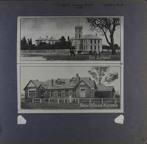
Album - Album page, Caulfield Grammar School, Glen Eira Road, Circa 1972
This photograph is part of the Caulfield Historical Album 1972. This album was created in approximately 1972 as part of a project by the Caulfield Historical Society to assist in identifying buildings worthy of preservation. The album is related to a Survey the Caulfield Historical Society developed in collaboration with the National Trust of Australia (Victoria) and Caulfield City Council to identify historic buildings within the City of Caulfield that warranted the protection of a National Trust Classification. Principal photographer thought to be Trevor Hart, member of Caulfield Historical Society. Most photographs were taken between 1966-1972 with a small number of photographs being older and from unknown sources. All photographs are black and white except where stated, with 386 photographs over 198 pages. In 1881, Reverend J H Davies founded Caulfield Grammar School in Elsternwick, Victoria with just nine students.Page 54 of Photograph Album with one photograph of two images of Caulfield Grammar School. The images are vertically arranged and joining.Hand written: Caulfield Grammar School / 1909 [middle top] / Glen Eira Road [top right ]/ 54 [bottom right]. Top image includes a printed title "Old School" and the bottom image "New Class Rooms".trevor hart, 1880's, 1890's, elsternwick, caulfield grammar school, reverend j h davies, education, glen eira road, st kilda east, church of england, double storey school buildings -
 Surrey Hills Historical Society Collection
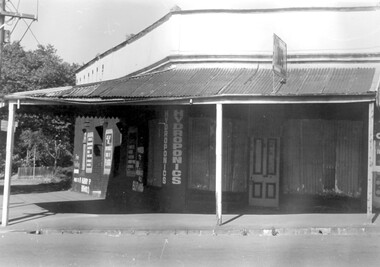
Photograph, 109 Union Road, Surrey Hills after fire damage
This building was damaged by fire and was subsequently demolished before June 1983. From 1901-1917 it was the site of the Surrey Hills Post Office. In later years the part of the building with frontage to Windsor Crescent was used as the dental surgery of Dr David Ellis; the Union Road part of the building was occupied by a barber and tobacconist for many years. At the time of the fire the building was used by a business supplying hydroponics requirements. This moved to (?) 119 Highbury Road, Burwood.The image is significant because it documents a building which was an important community facility which no longer exists.Black and white photo of a single-storey corner building with a corrugated iron roofed veranda and a single, 4-panel timber door. There is a sign with '109' mounted on the veranda of the building. There are multiple advertising signs on the walls of the building. Two of the windows are boarded up with corrugated iron sheets.shops, barber shops, tobacconists, surrey hills post office, dentists, union road, windsor crescent, hydroponics supplies, businesses, union road shops, dr david ellis -
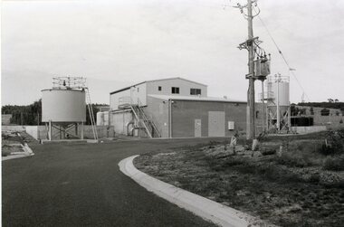 Stawell Historical Society Inc
Photograph, Grampians Wimmera Mallee Water Purification Plant in Crowlands Road
Grampians Wimmera Mallee Water Purification plant. Crowlands Road Stawell.Two different photographs of a building with storage tanks around the building. A power pole in front of the building and beside a curved road.grampians water supply -
 Greensborough Historical Society
Photograph - Digital Image, Marilyn Smith, Greensborough Grain Store, 183 Para Road. Display, 2014_08
This photograph shows a display (interior) of goods at the building at 183 Para Road when it was used for Greensborough Grain Store; this photo was taken in August 2014.In 2017, the Greensborough Grain Store closed its Para Road premises and now trades online.Digital copy of colour photographgreensborough grain store, para road greensborough -
 Ringwood and District Historical Society
Photograph, Northward view from Mullum Road corner, Oban Road, Ringwood - 1981
Written on back of photograph, "E622, N6, 1981. Oban Road between Mullum and Wonga Roads (on skyline)".. -
 Ringwood and District Historical Society
Photograph, Ringwood East looking from corner Warrandyte Road and Wonga Road, 1960
Written on back of photograph, "Ringwood East looking from corner Warrandyte Road and Wonga Road, 1960". -
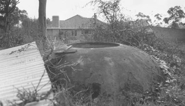 Ringwood and District Historical Society
Photograph, Old well at the corner of Warrandyte Road and Oban Road (N.E. corner) - 1964
Typed below photograph, "Old well at corner Warrandyte Road and Oban Road (N.E. corner) - 1964". -
 Ringwood and District Historical Society
Photograph, Canterbury Road shops, corner Armstrong Road, Heathmont, looking east - 1973
Catalogue card reads, "Canterbury Road shops, corner Armstrong Road, Heathmont, looking east - 1973". -
 Eltham District Historical Society Inc
Photograph, Liz Pidgeon, Heritage Excursion; Eltham Lower Park Walk and Talk, 1 July 2017, 1 July 2017
Looking towards Hohnes Road from the Diamond Creek trail in the Park. Newsletter No., 234, June 2017 Heritage Excursion - Saturday 1st July - Eltham Lower Park - Walk and Talk Eltham Lower Park has played an important part in the history of our area since the early days of European settlement when it was used by local residents as an informal racecourse. Prior to that its location at the junction of the Diamond Creek and the Yarra River made it an important meeting place for the Wurundjeri people. The park combines formal elements and sporting facilities with remnant bushland that is of environmental significance. It is home to sporting and horse riding clubs, popular play spaces and the Diamond Valley Miniature Railway, which attracts large numbers of visitors. The park will be the venue for our July excursion which will comprise a walk of about 3.5 km around the park and adjacent areas. Along the way we will discuss the history and natural history of the area. The path along the creek and the river provides a pleasant and scenic walk. This walk on Saturday 1st July is about 3.5 km in length and will take 2 to 2.5 hours. It will start at 2pm at the Main Road car park at the front of the park. (Melway ref 21 H 10). Born Digitalheritage excursion, activities, eltham district historical society, eltham lower park, hohnes road, diamond creek trail -
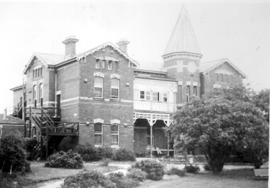 Surrey Hills Historical Society Collection
Photograph, Nethercourt Private Hospital, Union Road Surrey Hills in late 1930s
In 1935 Mrs Eliza tank transferred her private hospital 'Nethercourt' from Wilson Street to 219-223 Union Road. She has operated it at the Wilson Street address from 1916. The Union Road building had originally been Surrey College, a boarding school for boys built in 1889 by Rev Dr Darling. It was not the success hoped for. In 1905 it briefly became Milverton College for girls, after which it was used as a nursing home or small private hospital. By the 1960s it was known as 'Norwich Hospital' and later still 'St Jude's'. It closed as a hospital in 1983. The land at the front facing Union Road was sub-divided off and the building became a private home fronting Barton Street. As a private residence it was rendered and painted.Black and white photo of a double-storey brick building with a tower. There is a veranda between the tower and one of the wings of the building. This is enclosed at the upper level. On one side there is an external set of stairs and an out building. The building is approached by a circular driveway. There are mature bushes in front of the building.On copy photo in lead pencil: "? No & if missing"; "This is a copy"; "595"nethercourt hospital, milverton college, matron eliza tank, norwich private hospital, rev darling, st judes private hospital, hospitals, surrey college -
 Eltham District Historical Society Inc
Photograph, Stokes family with horse and sled, Nyora Road, Eltham, c.1950, 1950c
Taken from outside the family home on the southest corner of the intersection of Nyora Road and Pitt Street with Eucalyptus Road, looking northeast across the Stokes Orchard Frank Stokes with children, Dorothy (left), Beryl and David Frank Stokes first traveled to the district by train in 1944 to find land with the intention to establish an orchard. By chance he met Arthur Bird of Bird Orchard (bounded by Pitt Street, Eucalyptus Road and Wattle Grove) and they got talking over their common interest. Arthur put Frank up for the night and pointed out the land, part of Crown Allotment 15, Section 5, Parish of Nillumbik (CA15) somewhat diagonally opposite Bird Orchard. Frank bought the land and for the next two years would travel by train from Melbourne to Eltham every weekend establishing Stokes Orchard and building a home for his family, which they eventually moved into in 1946. In the mid 1970s the Shire of Eltham divided the orchard up into numerous rate-able parcel lots, which became affordable for Frank. As a consequence Stokes Orchard was turned into a housing development by Macquarie Builders and marketed as the Stokes Orchard Estate in two stages; Stage 1 encompassing Scarlet Ash Court, Ironbark Close and Peppermint Grove bounded by Nyora and Eucalyptus roads c.1976 and Stage 2 encompassing Stokes Place, Orchard Way, The Crest and The Lookout bound by Nyora and Diosma roads c.1979. The development of Orchard Way, The Crest and The Lookout did not proceed as planned due to the lack of the sewer along Diosma Road and so many of the proposed lots were incorporated into five-acre parcels instead.Representative of the orchard growing areas of ElthamDigital file only - Digitised by EDHS from a scrapbook (containing commercially printed photos of digital scans) on loan from Beryl Bradbury (nee Stokes), daughter of Frank Stokes.1950, beryl bradbury (nee stokes), beryl bradbury (nee stokes) collection, david stokes, dorothy stokes, eltham, frank stokes, horse, nyora road, sled, stokes orchard -
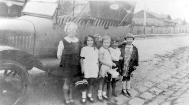 Surrey Hills Historical Society Collection
Photograph, Children in Wandsworth Road, Surrey Hills
Local children in Wandsworth Road, c1930 Taken outside No. 44, home of the Stalker family, later that of Howard and Mary Everard, nee Stalker. Betty Stalker is on the left. The car is a Dodge c1920. House just seen at left is No. 57 then home of the Butler family. To the right is No. 61, the Stevens family one. Further research: Betty Neil Smith (Stalker) was born in 1919 in Balwyn (Surrey Hills). She was one of 4 daughters of Alexander MacLaren Stalker (1885-1970/1973) and Charlotte Eleanor Hayward (1884-1953) who were married in 1911. Her sisters were, Betty Neil Stalker and Ruth McLaren Stalker (1913, Surrey Hills), Joan Winnock Stalker (1917, Surrey Hills) and Beatrice Mary Stalker (1919). Their mother Charlotte Hayward was a teacher prior to her marriage. Their father Alexander, an accountant, lived in Wattle Valley Road, Canterbury in 1910. From 1912-1931 they are listed at ‘Benwerrin’, (44) Wandsworth Road, Surrey Hills. This was later the home of Beatrice Mary and Howard Everard. Betty, Ruth and Joan later lived at 9/48 Wandsworth Road. The 1931 electoral roll has Olive Myra Butler (machinist), Herbert Arthur Butler (carpenter), Ernest Philip Butler (pastrycook), Mary Butler and Hilda Jarrett Butler (machinsit) at 59 Wandsworth Road ('Bona Vista'). The 1936 electoral roll has Hugh Joseph Stephens (fireman), Ada Agatha Stephens (HD), Mary Christina Stephens (dressmaker) and Sylvia Ada Stephens (dressmaker) at 63 Wandsworth Road. Hugh and Ada are at the address in earlier electoral rolls. It is presumed that these are the families referenced in the general information noted by Jocelyn Hall. A black and white photograph of some children standing beside a dodge car. At least one is a member of the Stalker family.surrey hills, wandsworth road, (mr) howard everard, (mrs) mary everard, (miss) mary stalker, (miss) betty stalker, dodge, butler family, stevens family, cars, (mrs) betty smith, (miss) beatrice mary stalker, (mrs) beatrice mary everard, (miss) joan winnock stalker, (miss) betty neil stalker, (miss) ruth mclaren stalker, bluestone kerbing, children -
 Orbost & District Historical Society
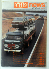
magazine, CRB News, August 1976
By 1910 it had become apparent that there was a need for a central roads authority to take over responsibility from the Board of Lands and Works for the care and management of the main roads of the state of Victoria. Because there was no consistent and systematic policy for road maintenance Victorian roads were in a deplorable condition. At this time the use of the motor car accentuated the demands for better roads. As a result of these needs the Country Roads Act 1912 was proclaimed in 1913 providing for the establishment of the Country Roads Board as a central road authority with responsibility for those roads within the State considered to be main roads. the C.R.B. was responsible for the construction of roads and bridges including the Snowy River road bridges in Orbost. This was a major project involving not only a new bridge over the Snowy River (including Lochiel Lagoon), but other bridges over Ashby’s Gulch and Watt’s Gulch. These new bridges were opened in November 1976 with the unveiling of a plaque on the eastern end of the $2.4M Snowy River Bridge. (ref. May Leatch) This is a useful reference tool on the history of the construction of the Snowy River road bridges.A journal, titled "CRB News" . On the front cover the title is in orange print with No. 33 August 1976 above a coloured photo of a truck carrying two tiers of new vehicles along a main sealed road. It contains information and photos of the construction of the Snowy River road bridges.on front cover - handwritten in black - "M. I. Gilbert"crb-news country-roads-board snowy-river-road-bridges -
 Ringwood and District Historical Society
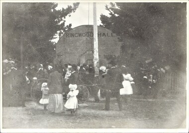
Photograph, Ringwood Hall, Mount Dandenong Road, Ringwood - circa 1900, Circa 1900
Ringwood Hall was located near the Club Hotel in Mount Dandenong Road prior to construction of Mechanics Institute/Town Hall in Maroondah Highway in 1909.Black & white photo of crowd gathered at original Ringwood Hall, Mount Dandenong Road, Ringwood. "Old Ringwood Hall nr. Club Hotel, later burnt down approx 1909". "Old Ringwood Hall prior to Mech Inst of 1909". -
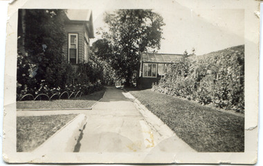 Surrey Hills Historical Society Collection
Digital photo, 45 Wandsworth Road, Surrey Hills, 1956
According to the donor, the photo was taken before the driveway was constructed. The house was later extended at the rear and was re-roofed. The donor's grandparents Daniel Patrick Liddy and Beatrice Bridget Tyner (known as 'Beat') were married in at her parents' home in Glencoe, South Australia on 13 December 1908. They lived in the Carlton / North Melbourne area before moving to Surrey Hills. Electoral rolls list them at 92 Curtain Street, North Carlton in 1913. According to the donor, they rented several properties before purchasing 45 Wandsworth Road. They are listed at Albert Crescent in 1914 and 1919, but also lived in Zetland Road. They purchased 45 Wandsworth Road in c1923 and are listed in the electoral rolls there in 1924. The donor's mother Ellen Dorothy Liddy (known as Eileen) was born in 1909; her brother Daniel John Liddy was born in 1911, both in Carlton. Daniel Patrick Liddy died in 1955; his wife Beatrice died in 1959. They are buried in Box Hill Cemetery (RC183-0045). 45 Wandsworth Road was their home for over 30 years.This image is material evidence of a property that has been demolished.A black and white photo taken from the street looking up a path or narrow driveway. On the LHS is part of a weatherboard house, Edwardian in style. On the RHS is the boundary fence against which is a garden border separated from the driveway by a section of grass. In the background is a glasshouse.Rear along top edge in blue biro: "Aunty Eileens house / before she was married" - according to the donor, this is his cousin's writing. Aunty Eileen was Ellen Dorothy Liddy who married Hugh Turnbull in 1936. Along LH edge, perhaps in a different hand " 23-10-1956" Photo laboratory processing stamp in black ink " 2 48", stamped twice.wandsworth road, daniel patrick liddy, beatrice bridget tyner, beatrice bridget liddy, ellen dorothy liddy, daniel john liddy, box hill cemetery, gardens -
 Glen Eira Historical Society
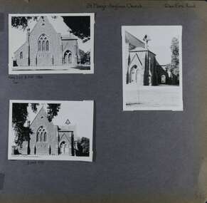
Album - Album page, St Mary's Anglican Church, Glen Eira Road, Circa 1972
This photograph is part of the Caulfield Historical Album 1972. This album was created in approximately 1972 as part of a project by the Caulfield Historical Society to assist in identifying buildings worthy of preservation. The album is related to a Survey the Caulfield Historical Society developed in collaboration with the National Trust of Australia (Victoria) and Caulfield City Council to identify historic buildings within the City of Caulfield that warranted the protection of a National Trust Classification. Principal photographer thought to be Trevor Hart, member of Caulfield Historical Society. Most photographs were taken between 1966-1972 with a small number of photographs being older and from unknown sources. All photographs are black and white except where stated, with 386 photographs over 198 pages.From the Victorian Heritage Register Database - Citation for St Mary's Anglican Church https://vhd.heritagecouncil.vic.gov.au/places/43715 (as at 14/10/2020) St Mary's has architectural significance as a representative example of French influenced Low and Mixed Gothic (see stylistic Typology in National Trust's Historic Churches Study) and is further distinguished by its use of bluestone, entirely without relief. French influence is demonstrated by the high nave, apsidal sanctuary, spirelet and trumeau. The building is locally important as a historic focus for Anglican worship and early mission activity whilst its architectural grandeur is expressive of mid Victorian Caulfield's status as a suburban location for the Metropolis gentry.Page 56 of Photograph Album with three exterior photographs (two portrait and one landscape) of St Mary's Anglican Church.Hand written: St Mary's Anglican Church Eira Road [top right] / Neg 235 8 Oct 1966 [under top left photo] / 3 Sep 1972 [under bottom left photo] / 56 [bottom right] trevor hart, 1880's, elsternwick, glen eira road, st kilda east, church of england, gothic, st mary's, bluestone, apsidal sanctuary, spirelet, trumeau, anglican, 1870's, caulfield north, french-influenced low and mixed gothic style -
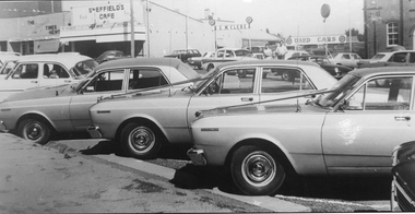 Stawell Historical Society Inc
Photograph, Wedding Vehicles in Main Street Stawell
Wedding vehicles in Main Street Stawell. Times News Office in Background, Sheffield's Café, G M McClure used Cars and Salvation Army Citadel. c1970transport, streetscape -
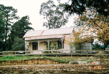 Eltham District Historical Society Inc
Photograph, Cottage, cnr. Reynolds Road and Mount Pleasant Road, Eltham 1990, 1990
Colour photograph of cottage at corner of Mount Pleasant Road and Reynolds Road, Eltham, 1990houses, eltham, mount pleasant road, reynolds road -
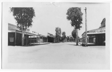 Tarnagulla History Archive
Photograph looking up Commercial Road, Tarnagulla, Looking up Commercial Road, Tarnagulla, c.1960s
Murray Comrie Collection. Original print.Monochrome photograph. View looking up Commercial Road, Tarnagulla, from the Poverty Street intersection. Street deserted - no people or vehicles visible. Building with text 'Williams & Clouston's' visible at far right. Willersdorf;s store opposite, and the Borough Council Chambers can vaguely be seen in the left distance. tarnagulla, businesses, commercial road -
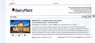 Greensborough Historical Society
Advertising Leaflet, 2/129 Mountainview Road Briar Hill, 29/06/2018
2/129 Mountainview Road Briar Hill, 3 bedroom, 2 story home. Sold 29/06/2018 for $638.500, previously March 2014 for $475,000Real estate advertising leaflet, 1 sheet, printed in colour.mountainview road briar hill -
 Greensborough Historical Society
Photograph - Digital Image, Marilyn Smith, Greensborough Grain Store, 183 Para Road. Architectural detail, 06/11/2017
This photograph shows architectural details of the building at 183 Para Road when it was used for Greensborough Grain Store; front door and bluestone steps, trellis and internal shelving.In 2017, the Greensborough Grain Store closed its Para Road premises and now trades online.Digital copy of colour photographgreensborough grain store, para road greensborough -
 Whitehorse Historical Society Inc.
Document, Blackburn Road Rail Crossing Removal Project, 2012
Information update issued by VicRoads.Information update issued by VicRoads regarding the planned removal of the rail crossing at Blackburn Road, and improvements to the Blackburn Railway Station.Information update issued by VicRoads.blackburn railway crossing, blackburn railway station, blackburn road, blackburn -
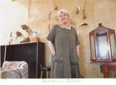 Lakes Entrance Historical Society
Photograph, EG Newspaper, Josephine Jakob artist shown in her studio with some of her creations Colquhoun Road Lakes Entrance
artist shown in her studio with some of her creations Colquhoun Road Lakes EntranceColour photograph of Josephine Jakob artist shown in her studio with some of her creations Colquhoun Road Lakes Entrancearts and crafts, events -
 Whitehorse Historical Society Inc.
Photograph - Strip photo and photocopy, Shops in Railway Road Blackburn, 1/08/1976 12:00:00 AM
Photo of South Parade and Main Street Blackburn.railway road, blackburn -
 Surrey Hills Historical Society Collection
Photograph, 2-4 Kent Road, Surrey Hills, 1987
'Rangitera' - 4 Kent Road - this house has been demolished. It was the address of Campbell Craven Dobbie c1909. He is variously listed as a commercial traveller / printer in electoral rolls. In 1906 he lived in Barton Street and from 1921-1914 is listed at 'Rangatea', Union Road, Balwyn. He served in WW1 in the 8th battalion as a captain; enlisted 4 September 1914 and returned 9 September 1916. Had a son Pat (REF: Trove Obituary, Argus, 27 March 1945)A black and white photograph of a Edwardian style / Federation style house with a cyclone fence and gate at the front of the property.kent road, surrey hills, campbell dobbie (capt), campbell craven dobbie (capt), world war 1, house names, 'rangitera', 'rangatea' -
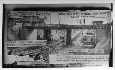 Melbourne Tram Museum
Photograph - Black and White, Epson Road Rail Bridge under construction, Early 1925
Image shows a newspaper photo of the MMTB U Class Tram 203 on temporary track at east side of excavation for underpass in Epson Road Flemington with Racecourse railway line to eliminate level crossing. The road was often closed to all traffic, including trams on race days by the railways. The work was completed in April 1925MMTB U Class trams were built for the former operator NMETL, with the photo showing an early level crossing abolition project. Black and White photo Epson Road Rail Bridge under construction with MMTB U Class tram on temporary track tramways, trams, epson road bridge, u class, flemington, tram 203 -
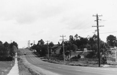
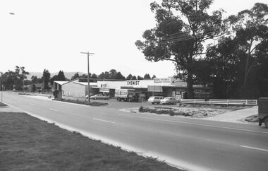
 Ringwood and District Historical Society
Photograph, Rear of shops- Main Street Ringwood early 1960's
Postcard size photograph'Written on back of photograph" Rear of shops Main Street Ringwood, early 1960's. Making way for Eastland carpark