Showing 22310 items
matching parks
-
 Wonga Park Community Cottage History Group
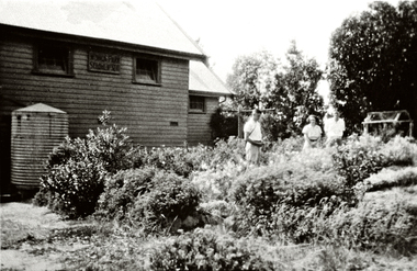
Photograph (Item) - Black and White, Wonga Park: School and garden, c. 1931
Wonga Park School and gardenPhoto is named 14880028.jpg on CD -
 Wonga Park Community Cottage History Group
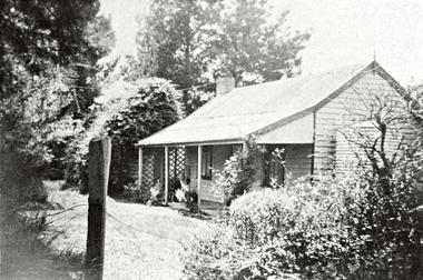
Photograph (Item) - Black and White, Wonga Park: The Oaks, 1930s, c. 1931
Wonga Park: The Oaks 1930sPhoto is named 14880028.jpg on CD -
 Eltham District Historical Society Inc
Photograph, Liz Pidgeon, Heritage Excursion; Eltham Lower Park Walk and Talk, 1 July 2017, 1 July 2017
Looking towards Hohnes Road from the Diamond Creek trail in the Park. Newsletter No., 234, June 2017 Heritage Excursion - Saturday 1st July - Eltham Lower Park - Walk and Talk Eltham Lower Park has played an important part in the history of our area since the early days of European settlement when it was used by local residents as an informal racecourse. Prior to that its location at the junction of the Diamond Creek and the Yarra River made it an important meeting place for the Wurundjeri people. The park combines formal elements and sporting facilities with remnant bushland that is of environmental significance. It is home to sporting and horse riding clubs, popular play spaces and the Diamond Valley Miniature Railway, which attracts large numbers of visitors. The park will be the venue for our July excursion which will comprise a walk of about 3.5 km around the park and adjacent areas. Along the way we will discuss the history and natural history of the area. The path along the creek and the river provides a pleasant and scenic walk. This walk on Saturday 1st July is about 3.5 km in length and will take 2 to 2.5 hours. It will start at 2pm at the Main Road car park at the front of the park. (Melway ref 21 H 10). Born Digitalheritage excursion, activities, eltham district historical society, eltham lower park, hohnes road, diamond creek trail -
 Eltham District Historical Society Inc
Photograph, Liz Pidgeon, Heritage Excursion; Eltham Lower Park Walk and Talk, 1 July 2017, 1 July 2017
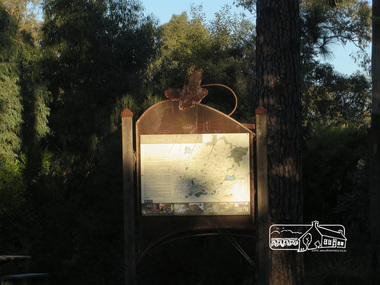
Information Board titled: Family Nature Trail - History of the land of Lower Eltham Park Newsletter No., 234, June 2017 Heritage Excursion - Saturday 1st July - Eltham Lower Park - Walk and Talk Eltham Lower Park has played an important part in the history of our area since the early days of European settlement when it was used by local residents as an informal racecourse. Prior to that its location at the junction of the Diamond Creek and the Yarra River made it an important meeting place for the Wurundjeri people. The park combines formal elements and sporting facilities with remnant bushland that is of environmental significance. It is home to sporting and horse riding clubs, popular play spaces and the Diamond Valley Miniature Railway, which attracts large numbers of visitors. The park will be the venue for our July excursion which will comprise a walk of about 3.5 km around the park and adjacent areas. Along the way we will discuss the history and natural history of the area. The path along the creek and the river provides a pleasant and scenic walk. This walk on Saturday 1st July is about 3.5 km in length and will take 2 to 2.5 hours. It will start at 2pm at the Main Road car park at the front of the park. (Melway ref 21 H 10). Born Digitalheritage excursion, activities, eltham district historical society, eltham lower park, information board, trail -
 Eltham District Historical Society Inc
Photograph, Liz Pidgeon, Heritage Excursion; Eltham Lower Park Walk and Talk, 1 July 2017, 1 July 2017
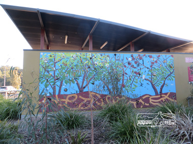
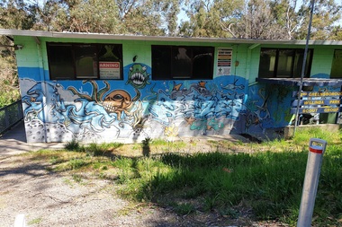
Mural artwork painted on the wall divider of the new toilet block at Eltham Lower Park Newsletter No., 234, June 2017 Heritage Excursion - Saturday 1st July - Eltham Lower Park - Walk and Talk Eltham Lower Park has played an important part in the history of our area since the early days of European settlement when it was used by local residents as an informal racecourse. Prior to that its location at the junction of the Diamond Creek and the Yarra River made it an important meeting place for the Wurundjeri people. The park combines formal elements and sporting facilities with remnant bushland that is of environmental significance. It is home to sporting and horse riding clubs, popular play spaces and the Diamond Valley Miniature Railway, which attracts large numbers of visitors. The park will be the venue for our July excursion which will comprise a walk of about 3.5 km around the park and adjacent areas. Along the way we will discuss the history and natural history of the area. The path along the creek and the river provides a pleasant and scenic walk. This walk on Saturday 1st July is about 3.5 km in length and will take 2 to 2.5 hours. It will start at 2pm at the Main Road car park at the front of the park. (Melway ref 21 H 10). Born Digitalheritage excursion, activities, eltham district historical society, eltham lower park, mural, tiolet block -
 Eltham District Historical Society Inc
Photograph, Liz Pidgeon, Heritage Excursion; Eltham Lower Park Walk and Talk, 1 July 2017, 1 July 2017
Sign at the front of the park which includes a map. Newsletter No., 234, June 2017 Heritage Excursion - Saturday 1st July - Eltham Lower Park - Walk and Talk Eltham Lower Park has played an important part in the history of our area since the early days of European settlement when it was used by local residents as an informal racecourse. Prior to that its location at the junction of the Diamond Creek and the Yarra River made it an important meeting place for the Wurundjeri people. The park combines formal elements and sporting facilities with remnant bushland that is of environmental significance. It is home to sporting and horse riding clubs, popular play spaces and the Diamond Valley Miniature Railway, which attracts large numbers of visitors. The park will be the venue for our July excursion which will comprise a walk of about 3.5 km around the park and adjacent areas. Along the way we will discuss the history and natural history of the area. The path along the creek and the river provides a pleasant and scenic walk. This walk on Saturday 1st July is about 3.5 km in length and will take 2 to 2.5 hours. It will start at 2pm at the Main Road car park at the front of the park. (Melway ref 21 H 10). Born Digitalelection day, heritage excursion, activities, eltham district historical society, eltham lower park, sign -
 Greensborough Historical Society
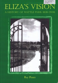
Book, Ray Pearce, Eliza's vision: a history of Wattle Park 1838-2006, 2006
An outline of the history of Wattle Park (Vic).207 p., illus., colour map.non-fictionAn outline of the history of Wattle Park (Vic).urban parks - melbourne, wattle park (vic.), parks - melbourne - history -
 Eltham District Historical Society Inc
Photograph, Russell Yeoman, 66 Susan Street, Eltham, c.1965, 1965c
Bridge Street on left. In 1965 the property was owned by the Shire of Eltham. 66 Susan Street was eventually developed into the Eltham Skate Park in the 1990s and the rest of the property is part of the Alistair Knox Park.Digital file only; created from original colour positive slide transparencyeltham, streets, houses, alistair knox park, eltham skate park, susan street, russell yeoman collection, bridge street -
 Greensborough Historical Society
Photograph - Photograph - Digital Image, Marilyn Smith, Willinda Park 2020, 14/10/2020
Digital images of Willinda Park taken in 2020. These photos show the 1-2nd Greensborough Willinda Park Scout Group hall and the adjacent toilet block with its mosaic parrot decoration.Part of a collection of miscellaneous historical images with a connection to the local area.Digital colour photographs scouts - greensborough, willinda park, mosaics, parks and reserves -
 Greensborough Historical Society
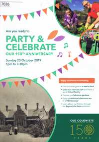
Pamphlet, Leith Park Celebration Day 2019 program, 20/10/2019
A celebration for the 150th anniversary of the establishment of the first Old Colonists Association of Victoria retirement village at Rushall Park North Fitzroy was held on 20 October 2019 at Leith Park St Helena. Leith Park was the Association's second village, built in the 1960s on land donated by Arthur C. Leith, Life Governor, Councillor and President of the Association 1949-1972.4 p. colour pamphlet printed on light cardboardleith park retirement village, old colonists association -
 RSL Victoria - Anzac House Reference Library and Memorabilia Collection
Photograph, Macleod Repatriation Sanitorium, circa 1914
The former Mont Park/Bundoora Psychiatric and Repatriation Hospitals Complex consisted of seven hospitals on a site of 185 hectares. The site comprising the Mont Park and Strathallen estates was consolidated by the Victorian government by purchase and transfer from the Closer Settlement Board in 1909 . The Mont Park Hospital commenced in 1910 with the building of the Farm Workers Block . In 1912 the landscape gardener Hugh Linaker was employed to layout the grounds of Mont Park and other State mental hospitals. The other hospitals were gradually split off from the Mont Park administration to form separate entities included among these was the Macleod Repatriation Hospital (1915), An agreement was made with the Defence Department in 1914 for the latter to erect the Mont Park central block (the "Chronic Wards") for use as a Military Hospital, and for it later to revert to the State as portion of Mont Park Hospital. The buildings now known as the Chronic Wards were completed in this way in 1916 and used as the Australian General Hospital no. 16 for the duration of the war. One wing of this building was set aside for mental patients during this period. Silver gelatin photographww1, macleod repatriation sanitorium, mont park -
 Bayside Gallery - Bayside City Council Art & Heritage Collection
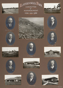
Photograph - gelatin silver photograph, H. Singer, Elsternwick Park Committee of Management 1935-36, 1936
elsternwick park, tennis, football, hockey, playground, sports pavilion, club, ralph tyner, l.l. chapman, cr. g.a. giles, cr. eustace tracey, cr. j.a. kennedy, chairman, cricket, c.e. tuxen, engineer, j.h. taylor, town clerk, treasurer, c.j. pollock, councillor, aerial view, golf, croquet, club house -
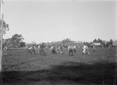 Bacchus Marsh & District Historical Society
Photograph, Football Match at Maddingley Park Bacchus Marsh 1900s
This photo is a very early example of an action image from an Australian Rules football match in a rural area in Victoria. The identity of the two teams is not confirmed. The team with the dark colored uniform is probably the Bacchus Marsh football team. The other team is possibly Parwan. The style of uniforms suggest the date of the photo is from around 1910 or possibly a few years earlier. This item has particular historic and social significance as an action image of two of the early sporting teams of Bacchus Marsh and district. These type of images are very rare for teams outside of the major metropolitan competitions such as the Victorian Football League of Victorian Football Association. It therefore provides a rare and fascinating depiction of an early football game as it was played and the ground conditions in which footballers played in the early 1900s.A black and white photograph produced from a digitized glass negative held by the State Library of Victoria titled, ‘Men and boys playing football on an oval set among trees and fields’ ca. 1910, Pictures Collection, State Library Victoria, H92.433/20. The description for the image held by the State Library of Victoria does not identify the location where the image was taken. By close comparison with other images of Maddingley Park held by the Bacchus Marsh and District Historical Society the location has been identified as Maddingley Park, Bacchus Marsh. A significant identifier for this image is the presence of the Evans Pavilion in the background which was built in 1896. Trees and statues in the background on the left side of the image also match other images of Maddingley Park from this time.australian rules football, bacchus marsh football club, australian rules football action images -
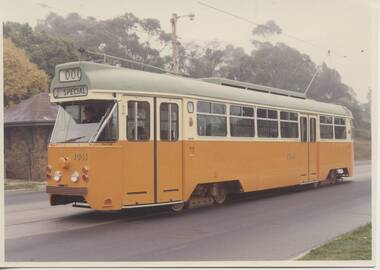 Melbourne Tram Museum
Photograph - Prototype tram PCC 1041, Public Transport Corporation (PTC), 1973
Provides publicity photographs of the prototype PCC tram 1041, that lead to the construction of the Z class trams.Yields information about prototype tram 1041Set of four colour prints and one black and white print of prototype tram 1041 on Riversdale Road, with Wattle Park in the background, second half of 1973, during commissioning and testing phase. .1 - tram showing special and route 000 - has been printed so that the background above the tram has been partly faded. Both printed on Kodak Paper. .2 - tram showing W. Park - Elgar Rod, route 070 - two copies .3 - similar to .2, at different location with park in background. Printed on Kodak paper. .4 - same as .1 - Has PTC copyright stamp on rear and number 3953 - better colour. .5 - black and white print - with PTC stamp and number 3953.tramways, trams, mmtb, prototype tramcar, tram 1041, riversdale road, wattle park -
 Melbourne Tram Museum
Letter, Melbourne & Metropolitan Tramways Board (MMTB), Letter regarding scout week celebrations, 16 February 1944, 23 February 1944
1 - Copy of letter from F Sanders to Secretary MMTB advising of Scout event at Como Park, requesting extra tram service. 2 - Copy of letter from unnamed manager to Mr FRG Sanders, General Secretary, Boy Scouts Association, regarding inability to provide extra tram services for Scout Week Celebrations at Como Park on 26 February 1946. Commonwealth restrictions, power restrictions and labour shortages prevent this from occurring. 3 - Memo titled "Scout Week Celebrations Camp Fire at Como Park, Saturday, 26th February, 1944 Commencing 8.15pm". Memo from Dist Traffic Supt SS to Mr McCutchan, Hanna St Depot & Mr Fisher, Hawthorn DepotPencil comments to Mr Harry to notetrams, tramways, events, parades, scout jamboree, hanna st depot, hawthorn depot -
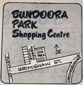 Greensborough Historical Society
Photograph - Newspaper Clipping - Digital Image, Diamond Valley News, Bundoora Park shopping centre 1971, 1971
in 1971 this area was called Bundoora Park and the shops had same name. It has been renamed Andrew Place Shopping Centre as people confused it when Bundoora Park in Plenty Road opened. Digital copy of newspaper advertisementbundoora park shops, andrew place shops, grimshaw street bundoora -
 Kew Historical Society Inc
Photograph - 'Fernhurst', 13 Fernhurst Grove, 1978
George Wharton arrived in Melbourne in 1844. An architect and surveyor, he was appointed to lay out the 'Village of Kew' by N.A. Fenwick following the land sales of 1851. A protagonist for Kew's separation from the Boroondara District Road Board, he was elected chairman when Kew achieved municipal status in December 1860. His home, 'Fernhurst', was built in 1866 on eight acres in Studley Park, with a four-storey tower and pyramidal roof. The Italianate home was a prominent Kew landmark. It was demolished in 1979 and replaced by St Paul's College in 1980.Rare colour photograph of what was once a significant mansion in Kew.Original colour positive photograph (Kodak print) of 'Fernhurst' in 1978. Photographed by Stewart West in May 1978, one year before it was demolished, the photograph gives little idea of the large landholding once surrounding the house. Originally accessed from near the corner of Princess Street and Studley Park Road, its gardens had been subdivided in the 1900s and its footprint restricted to 13 Fernhurst Grove. Like many other grand houses, by the 1970s it had been converted into apartments. From the photograph, one can see that the house had retained many of its original features such as the distinctive tower and the wide bow-fronted verandah. The slates on the roof (apart from those on the tower) had been replaced by tiles and the cement render of the exterior painted white. Annotated reverse: "View of Fernhurst Home Taken from Street / 10"fernhurst, 13 fernhurst grove -- kew (vic.), george wharton, italianate architecture, vila maria society, st paul's school for the blind -
 Kew Historical Society Inc
Photograph - 'Fernhurst', 13 Fernhurst Grove, 1978
George Wharton arrived in Melbourne in 1844. An architect and surveyor, he was appointed to lay out the 'Village of Kew' by N.A. Fenwick following the land sales of 1851. A protagonist for Kew's separation from the Boroondara District Road Board, he was elected chairman when Kew achieved municipal status in December 1860. His home, 'Fernhurst', was built in 1866 on eight acres in Studley Park, with a four-storey tower and pyramidal roof. The Italianate home was a prominent Kew landmark. It was demolished in 1979 and replaced by St Paul's College in 1980.Rare colour photograph of what was once a significant mansion in Kew.Original colour positive photograph (Kodak print) of 'Fernhurst' in 1978. Photographed by Stewart West in May 1978, one year before it was demolished, the photograph gives little idea of the large landholding once surrounding the house. Originally accessed from near the corner of Princess Street and Studley Park Road, its gardens had been subdivided in the 1900s and its footprint restricted to 13 Fernhurst Grove. Like many other grand houses, by the 1970s it had been converted into apartments. From the photograph, one can see that the house had retained many of its original features such as the distinctive tower and the wide bow-fronted verandah. The slates on the roof (apart from those on the tower) had been replaced by tiles and the cement render of the exterior painted white. Annotated reverse: "Fernhurst from higher ground level side shot / 7"fernhurst, 13 fernhurst grove -- kew (vic.), george wharton, italianate architecture, vila maria society, st paul's school for the blind -
 Kew Historical Society Inc
Photograph - 'Fernhurst', 13 Fernhurst Grove, 1978
George Wharton arrived in Melbourne in 1844. An architect and surveyor, he was appointed to lay out the 'Village of Kew' by N.A. Fenwick following the land sales of 1851. A protagonist for Kew's separation from the Boroondara District Road Board, he was elected chairman when Kew achieved municipal status in December 1860. His home, 'Fernhurst', was built in 1866 on eight acres in Studley Park, with a four-storey tower and pyramidal roof. The Italianate home was a prominent Kew landmark. It was demolished in 1979 and replaced by St Paul's College in 1980.Rare colour photograph of what was once a significant mansion in Kew.Original colour positive photograph (Kodak print) of 'Fernhurst' in 1978. Photographed by Stewart West in May 1978, one year before it was demolished, the photograph gives little idea of the large landholding once surrounding the house. Originally accessed from near the corner of Princess Street and Studley Park Road, its gardens had been subdivided in the 1900s and its footprint restricted to 13 Fernhurst Grove. Like many other grand houses, by the 1970s it had been converted into apartments. From the photograph, one can see that the house had retained many of its original features such as the distinctive tower and the wide bow-fronted verandah. The slates on the roof (apart from those on the tower) had been replaced by tiles and the cement render of the exterior painted white. Annotated reverse: "Back view of Fernhurst / 8"fernhurst, 13 fernhurst grove -- kew (vic.), george wharton, italianate architecture, vila maria society, st paul's school for the blind -
 Kew Historical Society Inc
Photograph - 'Fernhurst', 13 Fernhurst Grove, 1978
George Wharton arrived in Melbourne in 1844. An architect and surveyor, he was appointed to lay out the 'Village of Kew' by N.A. Fenwick following the land sales of 1851. A protagonist for Kew's separation from the Boroondara District Road Board, he was elected chairman when Kew achieved municipal status in December 1860. His home, 'Fernhurst', was built in 1866 on eight acres in Studley Park, with a four-storey tower and pyramidal roof. The Italianate home was a prominent Kew landmark. It was demolished in 1979 and replaced by St Paul's College in 1980.Rare colour photograph of what was once a significant mansion in Kew.Original colour positive photograph (Kodak print) of 'Fernhurst' in 1978. Photographed by Stewart West in May 1978, one year before it was demolished, the photograph gives little idea of the large landholding once surrounding the house. Originally accessed from near the corner of Princess Street and Studley Park Road, its gardens had been subdivided in the 1900s and its footprint restricted to 13 Fernhurst Grove. Like many other grand houses, by the 1970s it had been converted into apartments. From the photograph, one can see that the house had retained many of its original features such as the distinctive tower and the wide bow-fronted verandah. The slates on the roof (apart from those on the tower) had been replaced by tiles and the cement render of the exterior painted white. Annotated reverse: "Fernhurst front view taken from across Fernhurst Grove / 6"fernhurst, 13 fernhurst grove -- kew (vic.), george wharton, italianate architecture, vila maria society, st paul's school for the blind -
 Kew Historical Society Inc
Photograph - 'Fernhurst', 13 Fernhurst Grove, 1978
George Wharton arrived in Melbourne in 1844. An architect and surveyor, he was appointed to lay out the 'Village of Kew' by N.A. Fenwick following the land sales of 1851. A protagonist for Kew's separation from the Boroondara District Road Board, he was elected chairman when Kew achieved municipal status in December 1860. His home, 'Fernhurst', was built in 1866 on eight acres in Studley Park, with a four-storey tower and pyramidal roof. The Italianate home was a prominent Kew landmark. It was demolished in 1979 and replaced by St Paul's College in 1980.Rare colour photograph of what was once a significant mansion in Kew.Original colour positive photograph (Kodak print) of 'Fernhurst' in 1978. Photographed by Stewart West in May 1978, one year before it was demolished, the photograph gives little idea of the large landholding once surrounding the house. Originally accessed from near the corner of Princess Street and Studley Park Road, its gardens had been subdivided in the 1900s and its footprint restricted to 13 Fernhurst Grove. Like many other grand houses, by the 1970s it had been converted into apartments. From the photograph, one can see that the house had retained many of its original features such as the distinctive tower and the wide bow-fronted verandah. The slates on the roof (apart from those on the tower) had been replaced by tiles and the cement render of the exterior painted white. Annotated reverse: "Front view of Fernhurst showing tower to advantage / 9"fernhurst, 13 fernhurst grove -- kew (vic.), george wharton, italianate architecture, vila maria society, st paul's school for the blind -
 Kew Historical Society Inc
Photograph - 'Fernhurst', 13 Fernhurst Grove, 1978
George Wharton arrived in Melbourne in 1844. An architect and surveyor, he was appointed to lay out the 'Village of Kew' by N.A. Fenwick following the land sales of 1851. A protagonist for Kew's separation from the Boroondara District Road Board, he was elected chairman when Kew achieved municipal status in December 1860. His home, 'Fernhurst', was built in 1866 on eight acres in Studley Park, with a four-storey tower and pyramidal roof. The Italianate home was a prominent Kew landmark. It was demolished in 1979 and replaced by St Paul's College in 1980.Rare colour photograph of what was once a significant mansion in Kew.Original colour positive photograph (Kodak print) of 'Fernhurst' in 1978. Photographed by Stewart West in May 1978, one year before it was demolished, the photograph gives little idea of the large landholding once surrounding the house. Originally accessed from near the corner of Princess Street and Studley Park Road, its gardens had been subdivided in the 1900s and its footprint restricted to 13 Fernhurst Grove. Like many other grand houses, by the 1970s it had been converted into apartments. From the photograph, one can see that the house had retained many of its original features such as the distinctive tower and the wide bow-fronted verandah. The slates on the roof (apart from those on the tower) had been replaced by tiles and the cement render of the exterior painted white. Annotated reverse: "Fernhurst corner shot through trees / 12-22"fernhurst, 13 fernhurst grove -- kew (vic.), george wharton, italianate architecture, vila maria society, st paul's school for the blind -
 Kiewa Valley Historical Society
Papers - Collection of newspaper articles re Kiewa Valley, 1970's
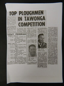
Newspaper articles describing incidents/news of the Kiewa Valley during the 1970's.Each article is significant because it is connected to people and places in the Kiewa Valley.9 photocopies of newspaper articles: 1. Fire at Mt Beauty Workmen's club 2. Ploughing Championship at Tawonga 24 Apr. 1971 3 & 4. Charles Derrick's 10 year anniversary of his death on Mt Hotham 5 Sept. 1975 5. Alps to be a National Park 15 July 1978 6. Tawonga Exchange to go Automatic 20 June 1974 7 & 8. Winter Playground 9. Alps National Parknewspaper articles; kiewa valley; news of the 1970s; -
 Bendigo Military Museum
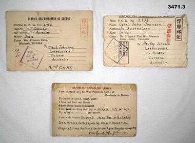
Postcard - CARDS, POW, c.1939 - 1945
The cards relate to Cyril John Johnson VX36298 died as a POW. Refer 3144 for his service history..1) Imperial Japanese Army POW card to Next of Kin. Plain cardboard. Address side has From/Sender Park-Camp at Moulmein, Burma. .2) Imperial Japanese Army POW card to Next of Kin. Plain cardboard. Address side has From/Sender Park-Camp at Moulmein, Burma. .3) Imperial Japanese Army POW card to Next of Kin. Plain cardboard. States he is interned in POW Camp Moulmein, Burma. .1) - .3) Red stamped Japanese characters & stamped passed by censor. .1) Handwritten address side: To Mrs J Johnson Laanecourie Victoria Australia Signed: C J Johnson Handwritten bottom address side: 2nd Card .2) Handwritten address side: To Mrs J Johnson Laanecourie Victoria Australia Signed: Cyril John Johnson POW No 2954 .3) Handwritten address side: To Mrs J Johnson Laanecourie via Maldonpost cards, japanese -
 Kew Historical Society Inc
Photograph - Victorian Canoe Club, Steaming gear, 1920-30
Canoeing on the River Yarra at Melbourne was an important and widespread recreational pursuit for Melbournians, especially in the first half of the twentieth century. The Victorian Canoe Club was formed in 1912 at a meeting in Melbourne and its first committee elected in the same year. Records indicate that the Club continued into at least the 1950s .The album has historic and social significance as a record of recreational activities (as well as canoe making) in the early years of the twentieth century. It has local significance as the site of the headquarters of the Club was in Studley park. A number of photographs in the album provide vistas of Kew on the Yarra that are otherwise unavailable.One of 24 labelled photos in part album, originating from the Victorian Canoe Club, which had its headquarters in Studley Park, Kew. The album includes a photographic record of canoe construction and also locations in Studley Park and Kew where the canoes were used. The subject of this photograph is identified as 'Steaming gear' which was the equipment used in a backyard to heat and soften the wood used to make a canoe so that it would be pliable and could respond to a mould."Steaming gear"victorian canoe club, canoe making, river yarra, burke road, mornington, studley park, kew, steaming gear, canoe construction -
 Kew Historical Society Inc
Photograph - Victorian Canoe Club, Y.M.C.A. Camp, Mornington, 1920-30
Canoeing on the River Yarra at Melbourne was an important and widespread recreational pursuit for Melbournians, especially in the first half of the twentieth century. The Victorian Canoe Club was formed in 1912 at a meeting in Melbourne and its first committee elected in the same year. Records indicate that the Club continued into at least the 1950s .The album has historic and social significance as a record of recreational activities (as well as canoe making) in the early years of the twentieth century. It has local significance as the site of the headquarters of the Club was in Studley Park. A number of photographs in the album provide vistas of Kew on the Yarra that are otherwise unavailable.One of 24 labelled photos in part album, originating from the Victorian Canoe Club, which had its headquarters in Studley Park, Kew. The album includes a photographic record of canoe construction and also locations in Studley Park and Kew where the canoes were used. The subject of this photograph is identified as 'Y.M.C.A. Camp, Mornington' at which members of the club presumably were staying. If it is Camp Manyung, that would date the photo to at least 1930, when the camp was established."Y.M.C.A. Camp, Mornington"victorian canoe club, canoe clubs, ymca camps, ymca camp -- mornington (vic.) -
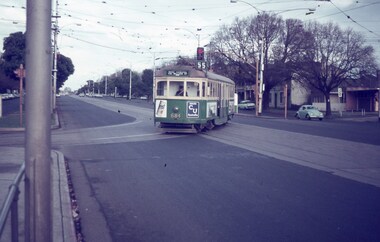 Melbourne Tram Museum
Slide - Set of 2, Keith Caldwell, 22/03/1969 12:00:00 AM
Set of two Agfa colour slide, blue and white plastic mount, photo by Keith Caldwell Oct. 22/3/1969 of trams on the Royal Park - West Coburg line, route 55. .1 - W5 684 turning onto the West Coburg via William St line from Flemington Road. Has advertisements for CU Insurance and First? drinks. .2 - W2 486 inbound in Royal Park, with destination of Domain Road Route 56..2 has "22/3/1969" in black ink.trams, tramways, route 55, west coburg, the zoo, flemington rd, route 56, royal park, domain rd, tram 684, tram 486, w2 class, w5 class -
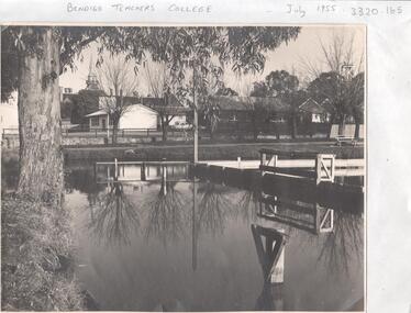 Bendigo Historical Society Inc.
Photograph - LA TROBE UNIVERSITY BENDIGO COLLECTION: BENDIGO TEACHERS' COLLEGE
A black and white photograph of Bendigo Teachers' College in July 1955. The photograph was taken by Mr. A.G. Davey or Mr. Tailor. The Municipal Baths are in the foreground and the Lookout Tower can be seen on the right hand side. On the right of the buildings which housed Rooms 3,4,5 and 6 is the brick building Room 2. In the background is the Camp Hill spire. Reflections of the trees and wooden constructions can be seen in the water. A vanguard car is parked in the school car park. See 3320.100bendigo, education, bendigo teachers' college, la trobe university bendigo collection, collection, bendigo, education, tertiary education, teacher training, bendigo teachers' college, photo, photos, photograph, photographs, site, place, municipal baths, camp hill state school, lookout tower, history, miss j.c. burnett, mr. geoff pryor -
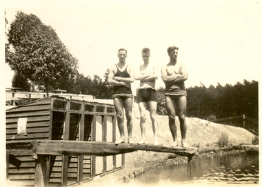 Federation University Historical Collection
Photograph - Photograph - Black and White, Frank Wright, Jack Cartasso and Jack Zilles at Creswick, 3/2/1930
Frank Wright was a renown resident of Smeaton, where he was born. He lived at Laura Villa, and attended Smeaton State School. His father William was a gold miner and his mother's name was Sarah. Their family won many singing and instrumental awards. Frank was tutored by Percy Code and was awarded a gold medal for the highest marks in the ALCM examinations in the British Colonies at the age of seventeen years. He became the Australian Open Cornet Champion by the age of eighteen. A year later, Frank conducted the City of Ballarat Band, and later the Ballarat Soldiers’ Memorial Band. He formed the Frank Wright Frisco Band and Frank Wright and his Coliseum Orchestra. These bands won many South Street awards, and Frank as conductor won many awards in the Australian Band Championship contest. In 1933 Frank Wright sailed to England to conduct the famous St Hilda’s Band and was later appointed Musical Director of the London County Council, where he organized many amazing concerts in parks, in and around the London district. He was made Professor of Brass and Military Band Scoring and conducted at the Guildhall of Music and Drama. Frank was often invited to adjudicate Brass Band Championships around Europe, in Australia, including South Street and in New Zealand. The Frank Wright Medal at the Royal South Street competition is awarded to an individual recognized as making an outstanding contribution to brass music in Australia..1) Black and white photograph of three men in bathing costumes standing with arms crossed on a diving board. In the background are changing rooms, a grassy bank and trees. The place is Calembeen Park at Creswick and the men are Jack Zilles, Jack Cartasso and Frank Wright. .2) Black and white photo taken at Creswick, The men on the diving board are Ron Hammond, Norman Jebart, Harley Chapman, Jack Cartasso and Frank Wright..1) Written in pencil on back - Jack Zilles, Jack Cartasso, Frank Wright, Creswick, Feb 3rd 1930 .2) Written on the back in pencil - Ron Hammond, Norman Jebart, Harley Chapman, Jack Cartasso, Frank Wright. Creswick Feb 3rd 1930bathing costumes, swimming, changing sheds, creswick, frank wright, calembeen park, jack zilles, jack cartasso, ron hammond, norman jebart -
 Stawell Historical Society Inc
Photograph, Fifty two colour photographs of Girl Guides and Brownies
Girl Guides and Brownies photographs 7120 -1 Baston Park 1988 -2 Regional Commissioner Irene Beckley farewell at Bastin Park -3 State Commissioner Mrs Wooley Nov 19, 1980 Church Parade -4 Evening to Farwell Iris Bickley Bastin Park 1988. Regional Comm -5 June Radford at rear in White Jumper -7 Katrina Sweeney, Kylie Whelan, Kerrie Rosenow, Church Parade Nov 19th, 1988 -8 Anzac Day 1988 -9 Susan Hart, Joy Gilsenan, Katrina Sweeney, Marti Osborne, Kylie Whelan, Water Activities 1988 -10 Water Activities 1988 -11 Megan Croft, Viv Neville, Bastin Park 1988 -12 Farwell to Iris Bickley, Bastin Park 1988, Region Comm -13 Bastin Park 1988 -14 Bastin Park 1988 -15 Camping at Jamboree 1988, Kaye Osborne -16 Water Activities 1988 -19 Leader Heather Duxon -20 On Right Leader Francis Croft -21 Lake Bolac 1981. Water activities day. -22 16th June 1983, Junior Leader Julie Nunn -23 23rd to 25th March 1984 Bastin Park, Linda Grellet, Rhonda Bullock, Anne McPherson -24 23rd to 25th March 1984 Bastin Park, Heather Duxon, Helen O’Shea -25 23rd to 25th March 1984 Bastin Park, Bernadette Moloney, Tania Cumming -26 23rd to 25th March 1984 Bastin Park test camp, Bernadette Moloney, Tania Cumming, Chris Collins -27 Taree, Francis Croft, Anne Maree -28 23rd to 25th March 1984 Bastin Park, Heather Duxson, Helen O’Shea -29 Neville & Beth Nunn and 2 daughters -30 23rd to 25th March 1984 Bastin Park, Tania Cumming, Chris Collens Test Camp -31 50 years of guiding Stawell, 1978 -32 Camp Bunjil 1981, Bastin Park -33 Taken at Kenga when Camper Van came up, Trainers Mrs Pert, Mrs Croft, Stawell April 1979 -34 50 years of Guiding -35 Camp Bunjil 1981 Bastin Park, Jacquelin Smith, Sarah Moreton -36 Striking Camp Region Camp Bastin Park 1983 -38 Camp Bunjil 1981 Bastin Park, 2nd from left Sharon Rhodes 1st Stawell, 4th Kathy Healy 2nd Stawell -39 Anzac Day 1983 -40 Megan Croft and Taree Francis Croft, 7th July 1983 -41 Dallas Campbell & Taree Francis Croft, 7th July 1983 -42 Anne Maree Waterhouse & Taree Francis Croft, 17th July 1983 -43 Mrs Pert Taken at Kenya April 1979 -44 Thank you Card 19-7-1984 Mrs Croft Taree -46 Thank you Card from E Raggatt -48 Activities at Camp Bunjil Bastin Park 1981 -49 Camp Bunjil Bastin Park 1981 -50 Jacquilin Smith & Catheryn van Leeiogh (Pack Guides 1978) Brownie Levels -51 Camp Bunjil Bastin Park 1981, Brenda Donovan -52 Kanya Camp 1977 Circa 1980's colour photographs in plastic pocketsVarious inscriptions on back of photographs