Showing 10532 items
matching land
-
 Bendigo Historical Society Inc.
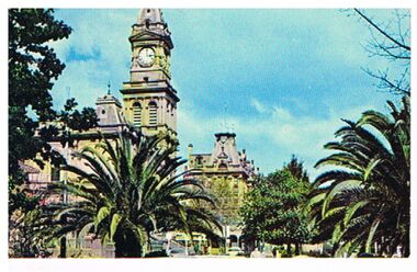
Postcard - POST OFFICE
Postcard: Image shows Bendigo Post Office, viewed from Pall Mall. Palm trees in foreground. On back ' Post Office Bendigo, Victoria' Built in the Italian renaissance style, and opened to the public in 1887, this fine building with its 142 foot clock tower is a local land mark.Plastichrome, Murfett Publishersbendigo, buildings, post office, post office, bendigo, italian renaissance, plastichrome, murfett publishers -
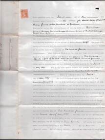
 Bendigo Historical Society Inc.
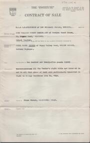
Document - H. A. & S. R. WILKINSON COLLECTION: CONTRACT OF SALE
Contract of sale dated 17th March, 1958 between Mr. J. W. R. McClelland (vendor) and Mr. C. B. Peters (purchaser). Property: Stone Street, California Gully being that piece of land described in Right to Occupy Residence Area no. 7613. Price: 125 pounds.organization, business, h.a. & s.r wilkinson real estate -
 Bendigo Historical Society Inc.
Document - VALUATION AND REPORT ON LAND AND PUBLIC BUILDINGS, 1888
Framed document, valuation and report on land and public buildings vis old survey office and Post Office and sub Treasury in View Street Sandhurst, hand written in black ink and signed N P Simpson Feby 22nd 1888. Under glass in a thin black wooden frame.document, certificate, public buildings -
 Port Melbourne Historical & Preservation Society
Document - Report, Ewan Ogilvy's Bayside Papers, Bayside EES Inquiry, Ewan Ogilvy's Bayside Papers, Box One, 1988
Ewan Ogilvy, former Melbourne Councillor and also of Community Services Victoria, Inner Urban Ministerial Advisory Committee and Uniting Church's Centre for Urban Research and Action (CURA), was instrumental in social justice approaches to town planning. He and CURA's Social Justice and the City Project funded Port Melbourne community groups protesting against the SCDC development in 1987. His files were presented to the Society in May 2001 on his preparation for leaving Victoria.From Ewan Ogilvy's chronologically organised 'Bayside Papers' relating to the proposed development of Port Melbourne industrial land in the late 1980s: EES Inquiry report to the Minister for Planning and Environment 7 April 1988, included in bound black file. Appendix 4: Bibliography; 7pp of documents and submissionsAll items signed 'Ewan Ogilvy'town planning, town planning - proposals shelved - bayside, public action campaigns, environmental issues, public housing, ewan ogilvy, centre for urban research and action, sandridge city development co pty ltd, scdc, linton r lethlean, judy arndt, francis b barnes -
 Bendigo Historical Society Inc.
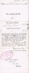
Document - JOHANSON COLLECTION: MORTGAGE MRS CATHERINE STUART RICHARDS
Conveyance of land, dated 23 May 1922, by Mrs. Isabella Melrose to Mr. H. R. G. Edwards. Attachment indicates a red coloured area conveyed to William Prout Bevan, dated 7 August 1937, Registered 18 August 1937 by Memorial No. 316, Book 555.bendigo, land sales, melrose, edwards, bevan, william prout bevan, isabella melrose , harold raymond george edwards. solicitor quick & luke murphy pall mall bendigo. -
 Bendigo Historical Society Inc.
Document - CONNELLY, TATCHELL, DUNLOP COLLECTION: DEED OF COVENANT MR. J.B. DAVIES TO T. LUXTON
Deed of Covenant between Mr. J.B. Davies to T. Luxton Esq., dated 5 August 1892. Pale blue two page document between John Bartlett Davies of Happy Valley Bendigo formerly called Sandhurst, gentleman, land registered in Office of Titles number 101598.cottage, miners, j.b. davies, happy valley road, thomas luxton, bendigo, sandhurst, deed of covenant -
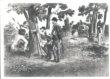 Bendigo Historical Society Inc.
Photograph - WES HARRY COLLECTION: SURVEY PARTY, 1854
Photograph of a drawing depicting a survey party in 1854. In the left foreground there are Two men, one is looking through a theodolite and another is blazing a mark on to a tree with an axe. Two other men are dragging a chain measure. In the background there is a boy standing by a horse and cart. The whole group is in a bush land setting.organization, lands and survey, original survey, surveying, theodilite, chain -
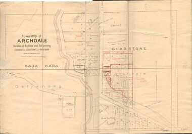 Bendigo Historical Society Inc.
Map - JACK FLYNN COLLECTION: TOWNSHIP OF ARCHDALE, /08/1904
Map: Township of Archdale, Parishes of Archdale and Dalyenong, Counties of Gladstone and Kara Kara. Scale 4 Chains to 1 Inch. Has attached letters relating to land transfers between the Estate of Kate Sanderson and Barry Frederick Mortlock also between Matilda Jane Sanderson and A. O. Proctor.J. K. Spark Narrister & Solicitor, Formerly Mitchell, Monotti & Sparkmap, gladstone, township, archdale, dalyenong, gladstone, kara kara -
 Bendigo Historical Society Inc.
Document - LYDIA CHANCELLOR COLLECTION: 93 MOLLISON STREET, BENDIGO
A six page document containing information on 93 Mollison Street Bendigo. Mr. Albert Bush first bought the land in 1865 and built the house in 1865. Included with the information is a letter to Miss Huxtable from Mr. Bob (Robert G.) Herriot an architect who purchased the house in 1973.bendigo, house, 93 mollison street, lydia chancellor collection, collection, building, home, albert bush, bendigo, house, houses, residence, mollison street, mr. robert g. herriot, architect -
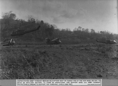 National Vietnam Veterans Museum (NVVM)
Photograph, Gibbons, Denis, Chinooks 1
A black and white photograph of Uinited States Army Chinook medium helicopters wait on Kanga pad at 1 ATF Base Nui Dat to move an artillery battery to form an operartional fire support base. U.S. Army Gunship protection is land to support the Chinooks (Circa June 1967)photograph, united states army, chinook, 1 atf, nui dat, gibbons collection catalogue, us army gunship, operational fire suport base, kanga pad -
Whitehorse Historical Society Inc.
Article - Newspaper cutting, Subdivision furore, 1994
Vermont South Traders and residents are opposing Shell Australia's plans to subdivide a prominent Nunawading Council owned site on Burwood Highway for a 24 hour petrol station, McDonalds and Video library and cafe.Vermont South Traders and residents are opposing Shell Australia's plans to subdivide a prominent Nunawading Council owned site on Burwood Highway for a 24 hour petrol station, McDonalds and Video library and cafe. Objectors say it is a conflict of interest for the council as the sale of the land is conditional on council approving the subdivision.Vermont South Traders and residents are opposing Shell Australia's plans to subdivide a prominent Nunawading Council owned site on Burwood Highway for a 24 hour petrol station, McDonalds and Video library and cafe.shops, shell australia, city of nunawading, vermont south shopping centre, burwood highway, vermont south, nos 473-493 -
Whitehorse Historical Society Inc.
Letter - Correspondence, Petition re Schwerkolt Cottage, 25/01/1994
Letter to Barbara Gardiner, Secretary, Nunawading Historical Society from Nunawading City Council to acknowledge receipt of a petition of 2237 signatures regarding Schwerkolt Cottage, re parking, wedding photography, availability of land owned by Melbourne Water or VicRoads, adjacent to the Cottage and formation of 'Friends of the Cottage' group.schwerkolt cottage, city of nunawading, gardiner, barbara, delahoy, jill -
Lakes Entrance Regional Historical Society (operating as Lakes Entrance History Centre & Museum)
Photograph, 1/11/1952 12:00:00 AM
Also another black and white photograph showing property Corumbene later subdivided fronted by Carpenter Street todayBlack and white photograph of the property Corumbene at back of photograph behind tall tree. White house in foreground Basil and Joan Mitchelson's, white house closer to Corumbene home of Jack and Aileen Daniel. Land adjacent to North Arm later subdivided for residential development Lakes Entrance Victoriajetties, waterfront -
Kew Historical Society Inc
Archive (Sub-series) - Subject File, Kew Historical Society, Queen Victoria Jubilee Fountain, 1958
Various partiesReference, Research, InformationSecondary Values (KHS Imposed Order)Subject file including typed historical notes by Sue Leong on the Queen Victoria Jubilee Fountain of 1897 which was once located on the apex of the triangular land bordered by Cotham Road and High Street which was subsequently relocated to the Alexandra gardens in the 1920s to make way for the Kew War Memorial.kew historical society - archives, kew - history, queen victoria's jubilee - 1897, drinking fountains - kew, monuments - kew (vic), memorials - kew (vic)kew historical society - archives, kew - history, queen victoria's jubilee - 1897, drinking fountains - kew, monuments - kew (vic), memorials - kew (vic) -
Whitehorse Historical Society Inc.
Document, Blackburn Cool Stores
Papers of Blackburn Cool Stores Pty Ltd, established 1917, comprising Box 1-1a: Minutes of Board of Directors 1916-1935, 1940-1987 (10 vols.); Sundry debtors 1983-1987; Pool Storage, Wages, Rent records 1981-1987; Petty Cash Book 1936-1987; Receipt book 1985-1987. Box 2: Ledgers and account books (6 vols) with Audit reports, bank statements, superannuation, shareholder lists, rentals, operating costs; Box 3: Share scrip certificates, rebuilding, plant and equipment estimates; Box 4: Land, company formation, services, provision documents; Work records for Alan Riescheck, Harry Wilson, Don Watts (2 vols)Papers of Blackburn Cool Stores Pty Ltd, established 1917, comprising Box 1-1a: Minutes of Board of Directors 1916-1935, 1940-1987 (10 vols.); Sundry debtors 1983-1987; Pool Storage, Wages, Rent records 1981-1987; Petty Cash Book 1936-1987; Receipt book 1985-1987. Box 2: Ledgers and account books (6 vols) with Audit reports, bank statements, superannuation, shareholder lists, rentals, operating costs; Box 3: Share scrip certificates, rebuilding, plant and equipment estimates; Box 4: Land, company formation, services, provision documents; Work records for Alan Riescheck, Harry Wilson, Don Watts (2 vols)Papers of Blackburn Cool Stores Pty Ltd, established 1917, comprising Box 1-1a: Minutes of Board of Directors 1916-1935, 1940-1987 (10 vols.); Sundry debtors 1983-1987; Pool Storage, Wages, Rent records 1981-1987; Petty Cash Book 1936-1987; Receipt book 1985-1987. Box 2: Ledgers and account books (6 vols) with Audit reports, bank statements, superannuation, shareholder lists, rentals, operating costs; Box 3: Share scrip certificates, rebuilding, plant and equipment estimates; Box 4: Land, company formation, services, provision documents; Work records for Alan Riescheck, Harry Wilson, Don Watts (2 vols)blackburn cool store, cool stores, blackburn, wilson, harry, orchards, fankhauser, margaret, fankhauser, eric, watts, don, riescheck, alan -
 Eltham District Historical Society Inc
Photograph, Mrs. Head, Grove Street
Mrs Emily Head, nee Whitehead (1874 - 1945) who lived in Grove Street, Eltham. She was the widow of fruit grower Richard Head. She owned land on the Bellevue Estate, land in and around north of Grove Street Eltham. The land was sub-divided in the 1960s. This photo forms part of a collection of photographs gathered by the Shire of Eltham for their centenary project book,"Pioneers and Painters: 100 years of the Shire of Eltham" by Alan Marshall (1971). The collection of over 500 images is held in partnership between Eltham District Historical Society and Yarra Plenty Regional Library (Eltham Library) and is now formally known as the 'The Shire of Eltham Pioneers Photograph Collection.' It is significant in being the first community sourced collection representing the places and people of the Shire's first one hundred years.Digital imagesepp, shire of eltham pioneers photograph collection, eltham, grove street, emily head, bellevue -
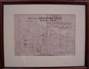 Glenelg Shire Council Cultural Collection
Map - Map of Drik-Drik, 1865
Displayed at History House.Print of map pasted onto board, mounted and framed under glass. Buff-coloured mount. Mahogany stained moulded wood frame, black inner frame.Front: Plan of the Agricultural Area of Drik-Drik L.2556/Prepared by the Board of Lands and Works in accordance with the "Amending Land Act 1865". Lands and Survey Office, Melbourne 11th May 1865. (printed, upper centre). Back: Duncan Hedditchmap, drik drik, plan, geography, cartography -
 Glenelg Shire Council Cultural Collection
Document - List - Wires and phone messages, n.d
Ledger page from account book of W. Vivian, saddler on reverse (plain) side, is a list of wires and phone messages paid by Mr. C. Smith, when W. Vivian died. List compiled by H. Vivian (son).Wirtes & phone Messages paid by Mr C Smith / When father died / J Jenkins Age a** 3/3 / Insurance on Stock 19/10 / Insurance on contents House & fittings 18/11 / Rates on land at Roseberry 1/6 -
 Ballarat Heritage Services
Photograph - Image, Guildford, Victoria, 1867
Black and white image of Guildford, near Castlemaine, VictoriaGUILDFORD Is a small township situated at the junction of Campbell's Creek and the Loddon. It is about seven miles from Castlemaine, on the road from that town to Ballaarat and Daylesford. The land near the Loddon is very rich, and as a large number both of theoretical and practical miners believe that a rich goldfield underlies the surface basalt, there is every probability of Guildford being ere an important goldfield. A large area of land in the neighbourhood has been already worked, principaIy by Chinamen, who until very recently mustered in great force in the locality. (Illustrated Adelaide Post, 23 March 1867)guildford, loddon river -
 Ringwood and District Historical Society
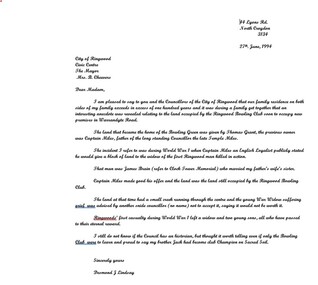
Letter, Cheevers, Margaret (Mayor), Letter from Margaret Cheevers to Desmond Lindsay referring to his work on the history of the site of the City of Ringwood Bowls Club - 2/08/1994, 2-Aug-94
Letter from Margaret Cheevers to Desmond Lindsay referring to his work on the history of the site of the City of Ringwood Bowls Club.Letter from Margaret Cheevers to Desmond Lindsay referring to his work on the history of the site of the City of Ringwood Bowls Club. One page,white paper, printed on Ringwood Council letter head. +Additional Keywords: Cheevers, Margaret (Mayor) / Lindsay, Desmond44 Lyons Rd. North Croydon 3134 27th. June, 1994 City of Ringwood Civic Centre The Mayor Mrs. B. Cheevers Dear Madam, I am pleased to say to you and the Councillors of the City of Ringwood that our family residence on both sides of my family exceeds in excess of one hundred years and it was during a family get together that an interesting anecdote was revealed relating to the land occupied by the Ringwood Bowling Club soon to occupy new premises in Warrandyte Road. The land that became the home of the Bowling Green was given by Thomas Grant, the previous owner was Captain Miles, father of the long standing Councillor the late Temple Miles. The incident I refer to was during World War 1 when Captain Miles an English Loyalist publicly stated he would give a block of land to the widow of the first Ringwood man killed in action. That man was James Brain (refer to Clock Tower Memorial) who married my father’s wife’s sister. Captain Miles made good his offer and the land was the land still occupied by the Ringwood Bowling Club. The land at that time had a small creek running through the centre and the young War Widow suffering grief was advised by another snide councillor (no name) not to accept it, saying it would not be worth it. Ringwoods’ first casualty during World War 1 left a widow and two young sons, all who have passed to their eternal reward. I still do not know if the Council has an historian, but thought it worth telling even if only the Bowling Club were to learn and proud to say my brother Jack had become club Champion on Sacred Soil. Sincerely yours Desmond J Lindsay -
 Bendigo Historical Society Inc.
Photograph - Historical Society Field Trip to the Springs at Sedgwick, Abt 2009
The Phil Wilkin Collection contains a series of 11 Items. The related items can be found by clicking on the reference link below. The following history of the Young family and their descendants who lived at the Springs is provided by Phil Wilkin. His Great Grandparents were Frances Young and August Wirth. Phil has also provided notes on the Wilkin Family and some history of the gold mining in Sedgwick. Frances Young's parents Joseph and Margaret Young owned the property called "The Old Place, Preston Vale or Wellington Flat" at Sedgwick near the Springs. Joseph Young owned and Managed the Standard Brewery which was located at Campbells Creek during the late 1800’s early 1900’s. Joseph and Margaret are buried in the Harcourt cemetery. In 1880 August Wirth lived at Mosquito Creek (Lake Eppalock, Victoria) when he married Frances Young. In 1902 they moved to part of Joseph Young's property. They milked cows and sold cattle for a living. One of their children Charles Wirth (Phil Wilkin's Grandfather) bought the land in 1935 after his parents had died. Charles Wirth was a councillor and also was president of the Shire of Strathfieldsaye. The "Old Place" was part of the property owned by members of the family. The old house at the Springs was burnt out by bushfire in January 1944 and much of the stonework was later vandalized by campers. The original Coliban Water Works were designed in 1863 by the Irish engineer Joseph Brady. The system included 70 kilometres of open water channels, aqueducts, syphons and tunnels to carry water (by gravity) from the Coliban River at Malmsbury, north to Castlemaine and Bendigo. Sedgwick is a locality in Central Victoria, Australia. It is located in the City of Greater Bendigo. Facilities include a public hall that opened in 1958 and CFA Rural fire station. It was named Upper Emu Creek until 1901 when it was renamed as Sedgwick after British geologist Adam Sedgwick.Twenty nine photos taken on a field trip by the Bendigo Historical Society to "The Springs" on the main Coliban water channel from Malmsbury to the Sandhurst Reservoir in Bendigo. The water race descends through a concrete chute, and continues sharply around the contour of the hills. Once it descended into a syphon across the gully. The are 182 photos in this series and can be found at 8683.1 to 8683.11. The series also includes photos of the surrounding farming land and the remains of an old house. There are also some notes on the pioneers of the district.history, bendigo, coliban water, joseph brady, irrigation, the springs, sedgwick -
 Bendigo Historical Society Inc.
Photograph - Historical Society Field Trip to the Springs at Sedgwick, Abt 2009
The Phil Wilkin Collection contains a series of 11 Items. The related items can be found by clicking on the reference link below. The following history of the Young family and their descendants who lived at the Springs is provided by Phil Wilkin. His Great Grandparents were Frances Young and August Wirth. Phil has also provided notes on the Wilkin Family and some history of the gold mining in Sedgwick. Frances Young's parents Joseph and Margaret Young owned the property called "The Old Place, Preston Vale or Wellington Flat" at Sedgwick near the Springs. Joseph Young owned and Managed the Standard Brewery which was located at Campbells Creek during the late 1800’s early 1900’s. Joseph and Margaret are buried in the Harcourt cemetery. In 1880 August Wirth lived at Mosquito Creek (Lake Eppalock, Victoria) when he married Frances Young. In 1902 they moved to part of Joseph Young's property. They milked cows and sold cattle for a living. One of their children Charles Wirth (Phil Wilkin's Grandfather) bought the land in 1935 after his parents had died. Charles Wirth was a councillor and also was president of the Shire of Strathfieldsaye. The "Old Place" was part of the property owned by members of the family. The old house at the Springs was burnt out by bushfire in January 1944 and much of the stonework was later vandalized by campers. The original Coliban Water Works were designed in 1863 by the Irish engineer Joseph Brady. The system included 70 kilometres of open water channels, aqueducts, syphons and tunnels to carry water (by gravity) from the Coliban River at Malmsbury, north to Castlemaine and Bendigo. Sedgwick is a locality in Central Victoria, Australia. It is located in the City of Greater Bendigo. Facilities include a public hall that opened in 1958 and CFA Rural fire station. It was named Upper Emu Creek until 1901 when it was renamed as Sedgwick after British geologist Adam Sedgwick.Twenty five photos taken on a field trip by the Bendigo Historical Society to "The Springs" on the main Coliban water channel from Malmsbury to the Sandhurst Reservoir in Bendigo. The water race descends through a concrete chute, and continues sharply around the contour of the hills. Once it descended into a syphon across the gully. The are 182 photos in this series and can be found at 8683.1 to 8683.11. The series also includes photos of the surrounding farming land and the remains of an old house. There are also some notes on the pioneers of the district.history, bendigo, coliban water, joseph brady, irrigation, the springs, sedgwick -
 Bendigo Historical Society Inc.
Photograph - Historical Society Field Trip to the Springs at Sedgwick, Abt 2009
The Phil Wilkin Collection contains a series of 11 Items. The related items can be found by clicking on the reference link below. The following history of the Young family and their descendants who lived at the Springs is provided by Phil Wilkin. His Great Grandparents were Frances Young and August Wirth. Phil has also provided notes on the Wilkin Family and some history of the gold mining in Sedgwick. Frances Young's parents Joseph and Margaret Young owned the property called "The Old Place, Preston Vale or Wellington Flat" at Sedgwick near the Springs. Joseph Young owned and Managed the Standard Brewery which was located at Campbells Creek during the late 1800’s early 1900’s. Joseph and Margaret are buried in the Harcourt cemetery. In 1880 August Wirth lived at Mosquito Creek (Lake Eppalock, Victoria) when he married Frances Young. In 1902 they moved to part of Joseph Young's property. They milked cows and sold cattle for a living. One of their children Charles Wirth (Phil Wilkin's Grandfather) bought the land in 1935 after his parents had died. Charles Wirth was a councillor and also was president of the Shire of Strathfieldsaye. The "Old Place" was part of the property owned by members of the family. The old house at the Springs was burnt out by bushfire in January 1944 and much of the stonework was later vandalized by campers. The original Coliban Water Works were designed in 1863 by the Irish engineer Joseph Brady. The system included 70 kilometres of open water channels, aqueducts, syphons and tunnels to carry water (by gravity) from the Coliban River at Malmsbury, north to Castlemaine and Bendigo. Sedgwick is a locality in Central Victoria, Australia. It is located in the City of Greater Bendigo. Facilities include a public hall that opened in 1958 and CFA Rural fire station. It was named Upper Emu Creek until 1901 when it was renamed as Sedgwick after British geologist Adam Sedgwick.Twenty six photos taken on a field trip by the Bendigo Historical Society to "The Springs" on the main Coliban water channel from Malmsbury to the Sandhurst Reservoir in Bendigo. The water race descends through a concrete chute, and continues sharply around the contour of the hills. Once it descended into a syphon across the gully. The are 182 photos in this series and can be found at 8683.1 to 8683.11. The series also includes photos of the surrounding farming land and the remains of an old house. There are also some notes on the pioneers of the district.history, bendigo, coliban water, joseph brady, irrigation, the springs, sedgwick -
 Bendigo Historical Society Inc.
Photograph - Historical Society Field Trip to the Springs at Sedgwick, Abt 2009
The Phil Wilkin Collection contains a series of 11 Items. The related items can be found by clicking on the reference link below. The following history of the Young family and their descendants who lived at the Springs is provided by Phil Wilkin. His Great Grandparents were Frances Young and August Wirth. Phil has also provided notes on the Wilkin Family and some history of the gold mining in Sedgwick. Frances Young's parents Joseph and Margaret Young owned the property called "The Old Place, Preston Vale or Wellington Flat" at Sedgwick near the Springs. Joseph Young owned and Managed the Standard Brewery which was located at Campbells Creek during the late 1800’s early 1900’s. Joseph and Margaret are buried in the Harcourt cemetery. In 1880 August Wirth lived at Mosquito Creek (Lake Eppalock, Victoria) when he married Frances Young. In 1902 they moved to part of Joseph Young's property. They milked cows and sold cattle for a living. One of their children Charles Wirth (Phil Wilkin's Grandfather) bought the land in 1935 after his parents had died. Charles Wirth was a councillor and also was president of the Shire of Strathfieldsaye. The "Old Place" was part of the property owned by members of the family. The old house at the Springs was burnt out by bushfire in January 1944 and much of the stonework was later vandalized by campers. The original Coliban Water Works were designed in 1863 by the Irish engineer Joseph Brady. The system included 70 kilometres of open water channels, aqueducts, syphons and tunnels to carry water (by gravity) from the Coliban River at Malmsbury, north to Castlemaine and Bendigo. Sedgwick is a locality in Central Victoria, Australia. It is located in the City of Greater Bendigo. Facilities include a public hall that opened in 1958 and CFA Rural fire station. It was named Upper Emu Creek until 1901 when it was renamed as Sedgwick after British geologist Adam Sedgwick.Twenty five photos taken on a field trip by the Bendigo Historical Society to "The Springs" on the main Coliban water channel from Malmsbury to the Sandhurst Reservoir in Bendigo. The water race descends through a concrete chute, and continues sharply around the contour of the hills. Once it descended into a syphon across the gully. The are 182 photos in this series and can be found at 8683.1 to 8683.11. The series also includes photos of the surrounding farming land and the remains of an old house. There are also some notes on the pioneers of the district.history, bendigo, coliban water, joseph brady, irrigation, the springs, sedgwick -
Bendigo Historical Society Inc.
Photograph - Phil Wilkin Collection - The Springs at Sedgwick 11 Items
The Phil Wilkin Collection contains a series of 11 Items. The related items can be found by clicking on the reference link below. The following history of the Young family and their descendants who lived at the Springs is provided by Phil Wilkin. His Great Grandparents were Frances Young and August Wirth. Phil has also provided notes on the Wilkin Family and some history of the gold mining in Sedgwick. Frances Young's parents Joseph and Margaret Young owned the property called "The Old Place, Preston Vale or Wellington Flat" at Sedgwick near the Springs. Joseph Young owned and Managed the Standard Brewery which was located at Campbells Creek during the late 1800’s early 1900’s. Joseph and Margaret are buried in the Harcourt cemetery. In 1880 August Wirth lived at Mosquito Creek (Lake Eppalock, Victoria) when he married Frances Young. In 1902 they moved to part of Joseph Young's property. They milked cows and sold cattle for a living. One of their children Charles Wirth (Phil Wilkin's Grandfather) bought the land in 1935 after his parents had died. Charles Wirth was a councillor and also was president of the Shire of Strathfieldsaye. The "Old Place" was part of the property owned by members of the family. The old house at the Springs was burnt out by bushfire in January 1944 and much of the stonework was later vandalized by campers. The original Coliban Water Works were designed in 1863 by the Irish engineer Joseph Brady. The system included 70 kilometres of open water channels, aqueducts, syphons and tunnels to carry water (by gravity) from the Coliban River at Malmsbury, north to Castlemaine and Bendigo. Sedgwick is a locality in Central Victoria, Australia. It is located in the City of Greater Bendigo. Facilities include a public hall that opened in 1958 and CFA Rural fire station. It was named Upper Emu Creek until 1901 when it was renamed as Sedgwick after British geologist Adam Sedgwick.The Phil Wilkin Collection contains a series of eleven Items about the Young family and their descendants who lived at the Springs and is provided by Phil Wilkin. His Great Grandparents were Frances Young and August Wirth. Phil has also provided notes on the Wilkin Family and some history of the gold mining in Sedgwick. The are 182 photos in this series and can be found at 8683.1 to 8683.11. The series also includes photos of the surrounding farming land and the remains of an old house. There are also some notes on the pioneers of the district.history, bendigo, coliban water, joseph brady, irrigation, the springs, sedgwick -
 Eltham District Historical Society Inc
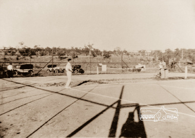
Photograph, Montmorency Tennis Club
Early 1930s tennis at Montmorency; tennis court with members, vintage cars and horse drawn vehicleEarly MontmorencyColour copy of original sepia photograph of Montmorency Tennis Courts c.1930s The Montmorency tennis courts were built in 1926-27. In 1926 the club leased the land at 10 pounds a year. By 1927 new dirt courts were constructed. (Montmorency: the farm on the plenty by Maureen Jones (2015) )tennis courts, montmorency -
 Bendigo Historical Society Inc.
Document - H.A. & S.R. WILKINSON COLLECTION: CONDITION OF SALE
Conditions of sale by private contract dated 11th May, 1925 between F. C. Neivandt and M. Hogan for land situate at 343 High Street described in certificate of title volume 3263 folio 652436, together with remains of 4-roomed brick and weatherboard house. Price 75 pounds.organization, business, h.a. & s.r wilkinson real estate -
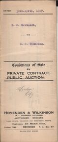 Bendigo Historical Society Inc.
Document - H.A. & S.R. WILKINSON COLLECTION: CONDITION OF SALE
Conditions of sale by private contract dated 30th. April, 1927 between F. C. Neivandt and D. G. Thompson for land situate corner Lily and Rowan Streets, Bendigo certificate of title volume 4355, folio 870999 together with 6-roomed weatherboard dwelling for the price of 270 pounds.organization, business, h.a. & s.r wilkinson real estate