Showing 32272 items
matching c
-
 Eltham District Historical Society Inc
Photograph, Russell Yeoman, Intersection of Fitzsimons Lane with Main Road, Eltham, c.1969, 1969c
Shows intersection of Old Eltham RoadDigital file only; created from original colour positive slide transparencystreets, eltham, main road, fitzsimons lane, old eltham road -
 Eltham District Historical Society Inc
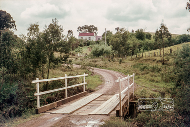
Photograph, Russell Yeoman, Long Gully Road Bridge over Long Gully at Panton Hill, c.1970, 1970c
The house on the hill burnt down in 1977Digital file only; created from original colour positive slide transparencystreets, panton hill, long gully, long gully road, bridge, russell yeoman collection -
 Eltham District Historical Society Inc
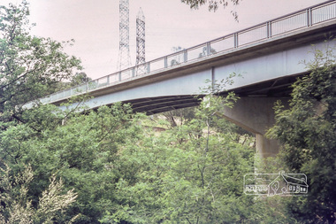
Photograph, Russell Yeoman, Fitzsimons Lane Bridge, c.1970, 1970c
New Fitzsimons Lane Bridge prior to duplicationDigital file only; created from original colour positive slide transparencystreets, eltham, bridge, fitzsimons lane bridge, fitzsimons lane, russell yeoman collection -
 Eltham District Historical Society Inc
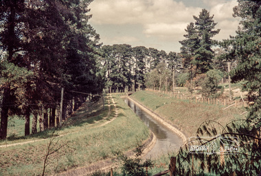
Photograph, Russell Yeoman, Maroondah Aqueduct, Research, c.1979, 1979c
Looking west, The Esplanade to the right and Ingrams Road Bridge in centre distance. Digital file only; created from original colour positive slide transparencymaroondah aqueduct, research (vic.), ingrams road, the esplanade, russell yeoman collection -
 Eltham District Historical Society Inc
Photograph, First house in Pryor Street, Eltham, c.1965, 1965c
This was the first house on Pryor Street which was located at the corner of what is now Commercial Place on the eastern side. Originally there was another house adjacent but it had been moved by the time of the 1951 aerial survey. The house was also the first home of Russell Yeoman who had been newly appointed to the Shire of Eltham and this house belonging to the council was vacant and made available to him for four weeks before it was relocated to Susan Street just south of the bowls club and was used a child care centre associated with the Living and Learning Centre (Russell believes). Russell then moved into another council owned house at the corner of Susan and Bridge Streets.Digital file only; created from original colour positive slide transparencyeltham, streets, houses, pryor street, susan street, fe holden sedan, russell yeoman collection -
 Eltham District Historical Society Inc
Photograph, First house in Pryor Street, Eltham, c.1965, 1965c
This was the first house on Pryor Street which was located at the corner of what is now Commercial Place on the eastern side. Originally there was another house adjacent but it had been moved by the time of the 1951 aerial survey. The house was also the first home of Russell Yeoman who had been newly appointed to the Shire of Eltham and this house belonging to the council was vacant and made available to him for four weeks before it was relocated to Susan Street just south of the bowls club and was used a child care centre associated with the Living and Learning Centre (Russell believes). Russell then moved into another council owned house at the corner of Susan and Bridge Streets.Digital file only; created from original colour positive slide transparencyeltham, streets, houses, pryor street, susan street, russell yeoman collection, fc holden sedan -
 Eltham District Historical Society Inc
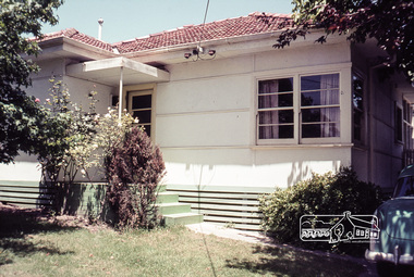
Photograph, Russell Yeoman, 66 Susan Street, Eltham, c.1965, 1965c
Sibbel factory in Brisbane Street in centre background running across view. In 1965 the property was owned by the Shire of Eltham. 66 Susan Street was eventually developed into the Eltham Skate Park in the 1990s and the rest of the property is part of the Alistair Knox Park.Digital file only; created from original colour positive slide transparencyeltham, streets, houses, alistair knox park, eltham skate park, herman sibbel, martin sibbel, sibbel factory, susan street, brisbane street, russell yeoman collection -
 Eltham District Historical Society Inc
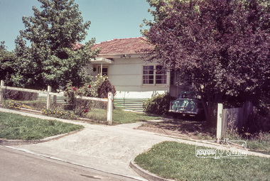
Photograph, Russell Yeoman, 66 Susan Street, Eltham, c.1965, 1965c
Bridge Street on left. In 1965 the property was owned by the Shire of Eltham. 66 Susan Street was eventually developed into the Eltham Skate Park in the 1990s and the rest of the property is part of the Alistair Knox Park.Digital file only; created from original colour positive slide transparencyeltham, streets, houses, alistair knox park, eltham skate park, susan street, russell yeoman collection, bridge street -
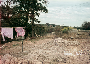 Eltham District Historical Society Inc
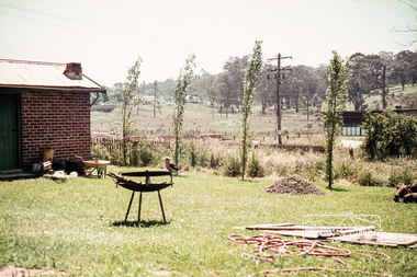
Photograph, Russell Yeoman, 66 Susan Street, Eltham, c.1965, 1965c
Looking southeast from backyard, Bridge Street visible under washing.Digital file only; created from original colour positive slide transparencyeltham, streets, susan street, eltham skate park, alistair knox park, bridge street, russell yeoman collection -
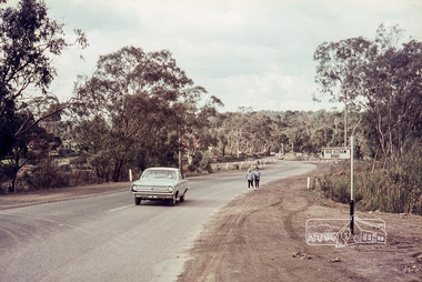
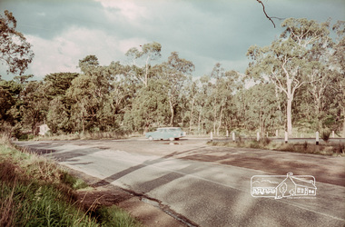 Eltham District Historical Society Inc
Photograph, Russell Yeoman, Intersection of Fitzsimons Lane with Main Road, Eltham, c.1969, 1969c
Digital file only; created from original colour positive slide transparencystreets, eltham, main road, fitzsimons lane, russell yeoman collection -
 Eltham District Historical Society Inc
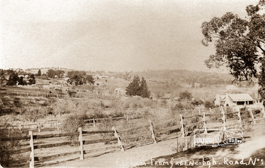
Photograph postcard, Eltham from Greensborough, Road No. 1., c.1910
Digital file only Postcards scanned from the collection of Michael Aitken on loan to EDHS, 13 Feb 2018michael aitken collection, postcards, eltham, greensborough, road no. 1 -
 Eltham District Historical Society Inc
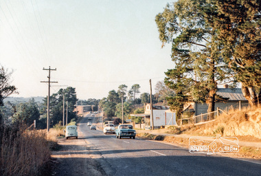
Photograph, Michael Aitken, Main Road, Eltham, c.1967, 1967c
Looking north from near Bridge Street. York Street on right.Digital file only Photo scanned from the collection of Michael Aitken on loan to EDHS, 13 Feb 2018michael aitken collection, postcards, eltham, main road, shillinglaw cottage, shillinglaw trees, york street, bakery -
 Eltham District Historical Society Inc
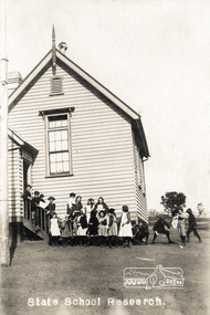
Photograph postcard, State School, Research, c.1910
Postcard inscribed on reverse "Eltham 26.12.12"Digital file only Postcards scanned from the collection of Michael Aitken on loan to EDHS, 13 Feb 2018michael aitken collection, postcards, research (vic.), state school -
 Eltham District Historical Society Inc
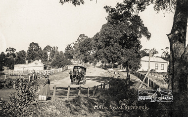
Photograph postcard, Main Road, Research, c.1910
View of area of Research shops looking east.Digital file only Postcards scanned from the collection of Michael Aitken on loan to EDHS, 13 Feb 2018michael aitken collection, postcards, research (vic.), main road -
 Eltham District Historical Society Inc
Photograph postcard, Entrance to Diamond Creek, c.1913
Digital file only Postcards scanned from the collection of Michael Aitken on loan to EDHS, 13 Feb 2018michael aitken collection, postcards, diamond creek, diamond creek mine -
 Eltham District Historical Society Inc
Photograph postcard, Diamond Creek Township, c.1913
Digital file only Postcards scanned from the collection of Michael Aitken on loan to EDHS, 13 Feb 2018michael aitken collection, postcards, diamond creek -
 Ringwood and District Historical Society
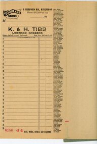
Financial record - Order book, K & H Tibb, licenced grocers, Ringwood (Victoria) - C 1960
Grey covered book, part used, perforated original and duplicate pages, blue carbon copy sheets, preprinted shopping list down right hand side of page, cardboard backing.Page heading - Your Foodland Store, 1 Bedford Road Ringwood Phone 870-2699 (2 lines) -
 Ringwood and District Historical Society
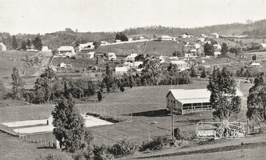
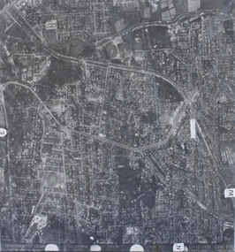
Photograph, Aerial photograph of Heathmont, Victoria - c.1960s, 1975
Aerial view of Heathmont - black and white photograph on chipboard backing. (Protected by slightly damaged plastic cover which could be removed for clearer image.)Department of Crown Lands and Survey Melbourne, Project Run 31A 27-12-1975, Lens 209 1951M ASL. -
 Ringwood and District Historical Society
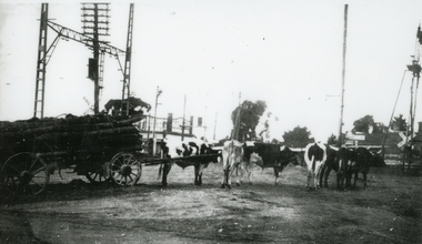
Photograph, Bullock team carting logs, on south side of Ringwood Railway Station near Bedford Road and Greenwood Avenue intersection - c.1930
Similar photo of same bullock team in archives (Lilian Burns Collection). Probably Paul Burns' rig, relative of Ron and Lilian Burns, Ringwood residents and RDHS members.Black and white laminated photo of bullock team carting logs, on south side of Ringwood Railway Station near Bedford Road and Greenwood Avenue intersection. +Additional Keywords: Burns, Paul / Burns, Ron / Burns, LilianCopyright Knox Historical Society -
 Ringwood and District Historical Society
Letter, Glenys Pollard, Letter from Glenys Pollard researching Mr Richard William Willoughby. C 1950, 20-Jul-99
Mr Richard William Willoughby was the Great Great Grandfather of Mrs Glenys Pollard.Letter from Glenys Pollard researching Mr Richard William Willoughby concerning a house built on the corner of Plymouth and Kalinda Roads Warrandyte. +Additional Keywords: Pollard, Glenys / Willoughby, Richard William -
 Ringwood and District Historical Society
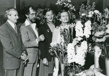
Photograph, Leader Associated Newspapers, Ringwood Garden Club floral display - Hartley Taylor, President, on left. C.1988
Photos are stored with a letter by Mrs E.V. Pullin, President Ringwood Historical Research Group Inc, dated 19 July 1988.Photograph of four people looking at floral display. L-R Hartley Taylor - President Ringwood Garden Club, Bob Flower - Waverley Garden Club, two ladies (perhaps from Waverley Garden Club, perhaps judges). +Additional Keywords: Taylor, Hartley / Flower, Bob / Pullin, Mrs E.V. / Lindsay, Mr J. / Cole, Gretta / Cole, Alex / McDonnell, Capt. Ralph -
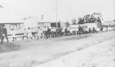 Ringwood and District Historical Society
Photograph, Ringwood School banner carried by children marching in procession past coolstore on Maroondah Highway, Ringwood, near the Wantirna Road corner. c.1920
-
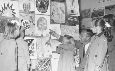 Ringwood and District Historical Society
Photograph, Albert Aird, c.1970 - Ringwood North State School children's art show
Typed below photograph, "Ringwood North State School. Presenting children's art show with Albert Aird". -
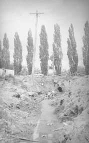 Ringwood and District Historical Society
Photograph, Ringwood Lake. Rebuilding drainage (c. late 1960's)
Written on back of photograph, "Ringwood Lake. Rebuilding drainage".(undated) -
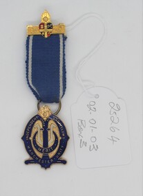 Ringwood and District Historical Society
Medal, Masonic presentation medal Ringwood c 1950s
R .Sharp was a well known Ringwood resident and orchardist.Blue and gold metal medal hung from a ribbon of blue with white stripes. Medal fastened by a gold safety pin on the top edge.Presented to Brother R. Sharp for services rendered to the Loyal Ringwood lodge, Manchester Unity, Independent Oddfellows. -
Ringwood and District Historical Society
Legal record - Conditions of Sale (C.E.Carter), Ringwood - Lot 100, Electric Railway Estate- Vendor Unstated to C Albon - 1925
Particulars and Conditions of Sale of Property , from Unstated to Emily Tilbury & Clarlotte Albon -
Ringwood and District Historical Society
Legal record - Conditions of Sale (C.E.Carter), Ringwood - Lot 24 , Plan of Subdivision No 3820, C Dobbin to Unstated Purchaser, 1928
Particulars and Conditions of Sale of Property , from Charlotte Dobbin to Unstated -
 Ringwood and District Historical Society
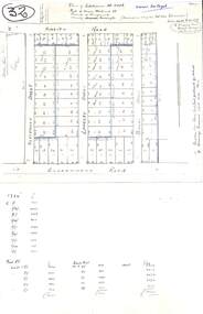
Plan, Plan of Subdivision No.11498 with handwritten costing notations - East Ringwood Central Estate c.1948
Two handwritten pages showing layout of Subdivision no 11498 with surveyor notations including property sizes and road construction cost calculations. Drainage easement 6 feet wide shaded blue.Plan of Subdivision No. 11498, Part of Crown Allotment 27, Parish of Ringwood, County of Mornington, (Certificate of Title Vol 5120 Fol 1023945). Owner Mr Vogel. Subdivision includes Knaith Road, Northwood Street, Langley Street, Bondi Street, and Government Road (later Alexandra Road), Ringwood East. G. Parsons & Sons, Licensed Surveyors, 389 Flinders Lane (Melbourne). -
 Ringwood and District Historical Society
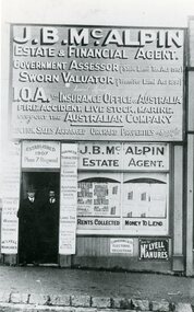
Photograph, Mr J.B.McAlpin's Office - Ringwood c 1918
Black and white photograph"Written on back of photograph" Mr J.B.McAlpin & Mr Clive Jones in doorway of Office. -
Ringwood and District Historical Society
Clothing, Baby's Dress Ringwood c.1927
Catherine Danby made this dress. She lived in Ringwood. Her daughter Ruth Webber( nee Danby) later lived in North Ringwood.White lawn nightdress with opening down the back. Lace insert around bodice and four pintucks above hem.