Showing 11366 items matching "land-clearing"
-
 Glenelg Shire Council Cultural Collection
Photograph - Photograph - Portland Harbour, Jul-92
Port of Portland Authority ArchivesFront: Back- 7/92- Blue pen -
Glenelg Shire Council Cultural Collection
Photograph - Photograph - No 6 Berth, n.d
Port of Portland Authority Archivesport of portland archives, portland harbour, no 6 berth, construction, ocean pier, lee breakwater -
 Ringwood and District Historical Society
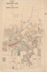
Map, Borough of Ringwood, Victoria - c.1950s
A0-size (approx) map of named streets and lot-numbered properties within Borough of Ringwood ward boundaries. Colour-coded key marking Land Under Control of Council, Factory Areas, and Business Areas.Scale: 8 chains to 1 inch. North Ward, East Ward, South Ward. -
 Bendigo Historical Society Inc.
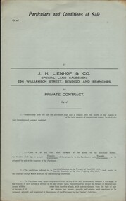
Document - CURNOW COLLECTION: FORM PARTICULARS AND CONDITIONS OF SALE, 1920 -1930's
Blank (unused) form - 'Particulars and Conditions of Sale'. 'by Private Contract' (by) J. H. Lienhop & Co. Special Land Salesmen, Williamson Street, Bendigo. Printer: Cambridge Press. Four pages, single-fold form.person, individual, curnow collection -
 Bendigo Historical Society Inc.
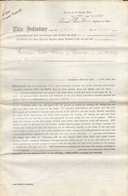
Document - BOOTH AND MCKENZIE ST MINING
Four page mining lease No 3155 PP [private property] issued to W J James 5th Dec 1896 on land below Booth and McKenzie St. One of five related documents. Unknown donor.bendigo, gold mining, w j james -
Port Melbourne Historical & Preservation Society
Document - File, EES submissions, Ewan Ogilvy's Bayside Papers, Box Two: Submissions to Bayside Project Public Inquiry 1987, 1987
Ewan Ogilvy, former Melbourne Councillor and also of Community Services Victoria, Inner Urban Ministerial Advisory Committee and Uniting Church's Centre for Urban Research and Action (CURA), was instrumental in social justice approaches to town planning. He and CURA's Social Justice and the City Project funded Port Melbourne community groups protesting against the SCDC development in 1987. His files were presented to the Society in May 2001 on his preparation for leaving Victoria.From Ewan Ogilvy's chronologically organised 'Bayside Papers' relating to the proposed development of Port Melbourne industrial land in the late 1980s: Bound file of written submissions to the EES Inquiry from the public: EPA, 40ppSigned 'Ewan Ogilvy'; additions to titletown planning, town planning - proposals shelved - bayside, public action campaigns, environmental issues, public housing, missions to seamen, ewan ogilvy, centre for urban research and action, sandridge city development co pty ltd, scdc, terry chumbley, linton r lethlean, peter atkins -
Port Melbourne Historical & Preservation Society
Legal record, Ewan Ogilvy's Bayside Papers, Box Three - Port Melbourne Bayside Development Development Agreement - contract of sale, 1987
Ewan Ogilvy, former Melbourne Councillor and also of Community Services Victoria, Inner Urban Ministerial Advisory Committee and Uniting Church's Centre for Urban Research and Action (CURA), was instrumental in social justice approaches to town planning. He and CURA's Social Justice and the City Project funded Port Melbourne community groups protesting against the SCDC development in 1987. His files were presented to the Society in May 2001 on his preparation for leaving Victoria.From Ewan Ogilvy's chronologically organised 'Bayside Papers' relating to the proposed development of Port Melbourne industrial land in the late 1980s: Stapled photocopies of Port Melbourne Bayside Development Development Agreement - contract of saleRust marks from bulldog clip top front cover. Signed 'Ewan Ogilvy'town planning, town planning - proposals shelved - bayside, public action campaigns, environmental issues, public housing, missions to seamen, ewan ogilvy, centre for urban research and action, sandridge city development co pty ltd, scdc, linton r lethlean, barry pullen - mlc -
Port Melbourne Historical & Preservation Society
Photograph - Rockery, newly planted garden area, Port Melbourne Uniting Church, Heather Wale, c. 2002
One of four photos taken early 2003 of newly planted garden area in front of Port Melbourne Uniting Church, where a 2001 plaque acknowledges the traditional custodians of the land (Wurundjeri and Bunnerwrung peoples): rockeryparks and gardens, religion - uniting church, australian aborigines, wurundjeri, bunnerwrung -
Port Melbourne Historical & Preservation Society
Photograph - Plaque, newly planted garden area, Port Melbourne Uniting Church, Heather Wale, c. 2002
One of four photos taken early 2003 of newly planted garden area in front of Port Melbourne Uniting Church, where a 2001 plaque acknowledges the traditional custodians of the land (Wurundjeri and Bunnerwrung peoples): plaqueparks and gardens, religion - uniting church, australian aborigines, wurundjeri, bunnerwrung -
 Bendigo Historical Society Inc.
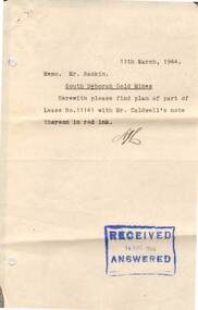
Document - MCCOLL, RANKIN AND STANISTREET COLLECTION: SOUTH DEBORAH GOLD MINES NL: APPLIC RESIDENCE AREA WITHIN LEASE, 26/2/1944
Document; McColl, Rankin and Stanistreet, South Deborah Gold Mines NL; Application to occupy residence area within company lease number 11141 Bendigo; land application number 92/5; 3 pagesorganization, mining, south deborah gold mines nl -
Clunes Museum
Document - CERTIFICATE OF TITLE, APRIL, 1906
ORIGINAL TITLE FOR THE CLUNES FREE LIBRARY SITE IN TEMPLETON STREET ISSUED TO RALPH COUNDON, GAS MANUFACTURER; ARTHUR HENRY GORDON, MEDICAL PRACTITIONER; AND JOHN FIELD, MINING REGISTRAR - 25TH APRIL, 1906. TITLE TRANSFERRED TO CROWN C.1975 AS NO TRUSTEES LEFTPhotocopy of a Certificate of Title issued in Victoria under the "Transfer of Land Act 1890" Issued on the 26th of April 1906 to the Trustees of the Clunes Free Lending Library from the Crown. Signed by H Hosken Assistant Registrar. Handwritten in black ink; J L Lazarus 1183842 Cluneslocal history, document, certificates, free library -
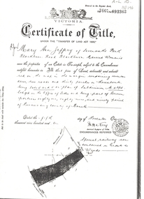 Whitehorse Historical Society Inc.
Land Title, Certificate of Title, 5/11/1910 12:00:00 AM
Photocopy of Certificate of Title issued to Mary Ann Jeffery of Sevenoaks Park, Blackburn Road, Blackburn for land between Blackburn Road and Lake Road dated 5 November 1910. Incomplete note refers to 'Railway'.sevenoaks park, blackburn road, blackburn, lake road, jeffery, mary ann -
Whitehorse Historical Society Inc.
Document, Laburnum Girl Guides
Brief history of Laburnum Girl Guides started in 1957. A co-operative was formed to raise the money for a hall to be built on land in Garie Street, Blackburn donated by Council (First co-operative in Victoria) opened 1964.Brief history of Laburnum Girl Guides started in 1957. A co-operative was formed to raise the money for a hall to be built on land in Garie Street, Blackburn donated by Council (First co-operative in Victoria) opened 1964.Brief history of Laburnum Girl Guides started in 1957. A co-operative was formed to raise the money for a hall to be built on land in Garie Street, Blackburn donated by Council (First co-operative in Victoria) opened 1964.laburnum girl guides, boulton (mrs), harvey (mrs) -
Whitehorse Historical Society Inc.
Document, Advance Blackburn
Copy of letter informing Blackburn residents of Nunawading Shire Council's grant of 75 pounds towards purchasing a block of land to run through from The Avenue to Blackburn Road and requesting donations from local residents.land subdivision, williams, e.g., page, chas. d, elmore, algernon john, shire of nunawading, the avenue, blackburn, blackburn road, south parade, francoms paddock, blackburn township estate, king's subdivision -
Whitehorse Historical Society Inc.
Article, Development threatens to bury famous artistic site, 2006
Residents have made a last-ditch call for the Federal Government to stop development on land where Frederick McCubbin painted his famous work 'Bush Burial' in 1890Residents have made a last-ditch call for the Federal Government to stop development on land where Frederick McCubbin painted his famous work 'Bush Burial' in 1890 (Photo of painting plus David McCubbin)Residents have made a last-ditch call for the Federal Government to stop development on land where Frederick McCubbin painted his famous work 'Bush Burial' in 1890blackburn lake sanctuary, mccubbin, frederick, mccubbin, david, wolseley crescent, blackburn, blackburn lake environmental education park committee, city of whitehorse, seventh day adventist church nunawading -
![Certificate of Title in the name of Carlton Brewery Limited, dated 27 May 1901. Land located in Whitehorse Road [Blackburn].](/media/collectors/56f368632162f118acbff12e/items/60d923306e5f99545134d9d9/item-media/632adfcbe9473391e3b84299/item-fit-380x285.jpg) Whitehorse Historical Society Inc.
Whitehorse Historical Society Inc.Certificate - Land Title, Carlton Brewery Limited, 27/05/1901 12:00:00 AM
Certificate of Title in the name of Carlton Brewery Limited, dated 27 May 1901. Land located in Whitehorse Road [Blackburn]. Includes various mortgages and transfers, the final to Eugene Gorman and Harry Jackman in 1929. Photocopied.carlton breweries ltd, whitehorse road, blackburn, turner, emily, travellers rest hotel, johnson, richard, brookes, william, herbert robinson, norman everard, harold eric, commercial bank of australia ltd., ivey, charles thomas godfrey, gorman, eugene, jackman, harry -
Whitehorse Historical Society Inc.
Document, Biography of Dr Francis John Drake, 1/11/1983 12:00:00 AM
A brief biography of Doctor Francis John Drake - medical practitioner and early land owner in the Mitcham area.A brief biography of Doctor Francis John Drake - medical practitioner and early land owner in the Mitcham area. Compiled by Andrew Hillier. Includes copies of Dr Drake's Marriage Certificate, entry in Register of Deaths and a portrait.A brief biography of Doctor Francis John Drake - medical practitioner and early land owner in the Mitcham area. drake, francis john, dr, park road, mitcham, heads road, donvale, mitcham north, whitehorse road, mitcham, elizabeth street, mitcham, station street, mitcham, colombo street, . mitcham, mitcham road, mitcham, doncaster east road, mitcham, mcdowall street, mitcham -
Whitehorse Historical Society Inc.
Document - Correspondence, Roads, 1935 - 1936
Correspondence between Mrs E. Sutton, her solicitors, Maddocks, Jamieson & Lonie, and the Shire of Blackburn and Mitcham re the purchase of land at cnr of Blackburn and Railway Roads, Blackburn for roadway, Oct 1935 - Aug 1936.blackburn road, blackburn, railway road, blackburn, sutton, mrs e, shire of blackburn and mitcham, maddocks, jamison & lonie solicitors, roads and streets -
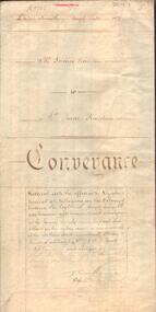 Bendigo Historical Society Inc.
Document - JOHANSON COLLECTION: CONVEYANCE JAMES PENISTAN TO ANNE PENISTAN
Legal document. On front 11th day of July, 1877. Mr. James Penistan to Mrs Anne Penistan. Land referred to: Allotment 10 of section 80. On bottom of front page : Thomas Crabbe, Solicitor, Sandhurst.bendigo, land sales, allot 10, sec 80 -
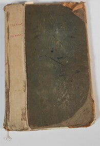 Bendigo Historical Society Inc.
Administrative record - Land Sales Register
Large land sales ledger with cloth binding on spine. 101 pages handwritten. Dates from 1908 - 1934. Ledger filled with names, addresses, financial details and remarks regarding clients. Ledger for Bendigo area.On front cover page written in red is '138 Front' and '130 Rear.' On the spine it is written in red, 'Bgo 130 +138, 138 Front, 130 Rear, 1 to 500.' On first page written in red "SEC 138 Front." Back cover is written '121 in back of book.'land sales, register -
 Bendigo Historical Society Inc.
Financial record - Axedale Waterworks Trust
Collection of documents pertaining to the Axedale Waterworks Trust. The documents range in date from 1963 to 1968 and covers: Audit reports, Chairman letters to shareholders, financial statements, land reports. Aileen and John Ellison Collection.axedale water trust, financial record -
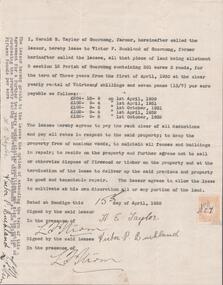 Bendigo Historical Society Inc.
Document - EDWIN BUCKLAND COLLECTION: AGREEMENT BY HAROLD E. TAYLOR AND VICTOR P. BUCKLAND
Document. Agreement by Harold E. Taylor and Victor P. Buckland re leasing of land Allotment 3, Section 3 12 Parish of Goornong, Containing 301 acres 3 roods for the term of Three years. -
Kew Historical Society Inc
Archive (Sub-series) - Subject File, Caritas Christi Hospice (Kew), 1958
Various partiesReference, Research, InformationSecondary Values (KHS Imposed Order)The Sisters of Charity bought land in Studley Park Road in 1937 and opened their first hospital there in 1938. The subject file contains a newspaper article/clipping published in the Progress Leader (2013) about the 75th Anniversary of the Hospice. caritas christi hospice, hospitals - kew (vic)caritas christi hospice, hospitals - kew (vic) -
Canterbury History Group
Ephemera - Maling's Tramway Estate, 1924
Brochure for the auction on 13 December 1924 of 40 building blocks comprising the Maling's Tramway Estate, Balwyn. Includes a small locality plan giving comparative prices per foot of land for some other suburbs.balwyn, malings tramway estate, land sales, land subdivision, shepreth street, the willows, meldreth street, whitehorse road, banool road, maling family, arthur tuckett & son, geo. m. hume -
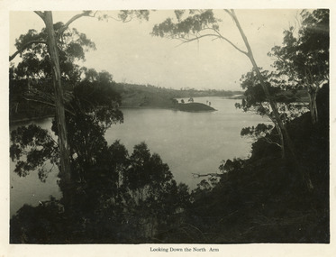 Lakes Entrance Historical Society
Postcard - North Arm, Bulmer H D, 1930c
Black and white large format postcard of a broad reach of the North Arm, showing the calm waters of the lake, natural vegetation in foreground, some land bordering lake has been cleared. Lakes Entrance VictoriaLooking down the North Armwaterways, vegetation -
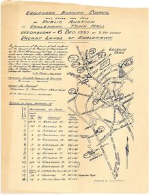 Bendigo Historical Society Inc.
Document - Auction Flyer
Auction flyer for Eaglehawk Borough Council. One page with title, map and land particulars on rectangular paper which is coloured light brown. One-page, light weight paper written by hand in black ink. eaglehawk borough council, auction, streets -
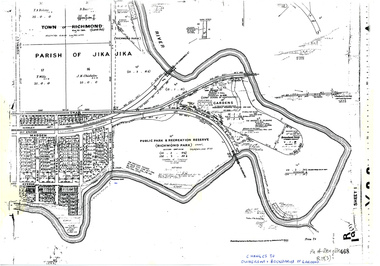 University of Melbourne, Burnley Campus Archives
Plan, Allan & Tuxen et al, Public Park & Recreation Reserve (Richmond Park), 1886-1996
Shows changes in ownership of various parts of Richmond Park and Burnley Gardens including University of Melbourne, Amrad, Melbourne City Link, etc. from gazettal in 1873 to 1996Photocopy of plan of Richmond Park and Burnley Gardens with University of Melbourne land acquisition 13.10.1994 hand drawn on it, dates Act revoked and Gazette numbers. Based on plan of Parish of Jika Jika R 19 (3)"Changes to ownership & boundaries of Gardens" in inkpublic parks, recreation reserve, richmond, parish if jika jika, burnley gardens, horticultural society of victoria -
 Bendigo Military Museum
Photograph - 4th Field Survey Squadron – Operation MIZMAZE 92, Kimberley region, Western Australia, 1992
This is a set of 40 photographs taken in 1992 during 4th Field Survey Squadron’s deployment on Operation MIZMAZE 92 in the Kimberley region of Western Australia from the 13th of May to the 14th of July 1992. The area of operations was Wyndham, Halls Creek and Sandfire Flat. It was a two-part operation involving the field completion of topographic maps and the acquisition of mapping control by GPS field parties utilising Texas Instruments TI4100 Global Positioning System receivers. Survey parties conducted field checking of topographic maps and GPS control acquisition in Perentie 110 Series Survey variant FFR Land Rovers. Three Bell Kiowa LOH helicopters provided by 162 Recce Sqn supported field checking and limited deployment of GPS surveys parties. C-l30 Hercules from 36 Sqn supported deployment and extraction of personnel and equipment to and from from the AO. A Cessna 404 Titan Ambassador from Vee-H Aviation was used as the Wild RC10 camera platform for aerial photography acquisition.This is a set of 40 photographs taken in 1992 during 4th Field Survey Squadron’s deployment on Operation MIZMAZE 92 in the Kimberley region of Western Australia. The colour photographs are on 35mm negative film and are part of the Army Survey Regiment’s Collection. The photographs were scanned at 96 dpi. .1) - Photo, colour, 1992. CAPT Craig Hersant. .2) - Photo, colour, 1992. Unidentified officer/soldier. .3) & .4) - Photo, colour, 1992. Aboriginal rock art - Wandjina Gunduran, Donkey Creek. .5) - Photo, colour, 1992. Aboriginal rock art - Track Wandjinas, Donkey Creek. .6) & .7) - Photo, colour, 1992. CAPT Craig Hersant. .8) - Photo, colour, 1992. Kimberley region topography. CPL Glen Weatherell. .9) - Photo, colour, 1992. Unidentified personnel .10) - Photo, colour, 1992. Supermarket at unknown location. .11) to .13) - Photo, colour, 1992. Caravan park at unknown location. .14) - Photo, colour, 1992. Old bridge at Fitzroy Crosssing. .15) & .16) - Photo, colour, 1992. Survey party in Perentie 110 Series Land Rover. .17) & .18) - Photo, colour, 1992. Kimberley region topography. .19) - Photo, colour, 1992. Kimberley region topography. CPL Glen Weatherell. .20) - Photo, colour, 1992. Kimberley region topography, possibly the Bungle Bungles. .21) - Photo, colour, 1992. Kimberley region topography. SGT Frank Downie. .22) - Photo, colour, 1992. Kimberley region topography: the Bungle Bungles. .23) - Photo, colour, 1992. Kimberley region topography: the Bungle Bungles. .24) - Photo, colour, 1992. Kimberley region topography: the Bungle Bungles. SPR Neil Pedler. .25) & .26) - Photo, colour, 1992. Kimberley region topography: the Bungle Bungles. .27) - Photo, colour, 1992. Kimberley region topography. .28) - Photo, colour, 1992. Survey party with Perentie 110 Series Land Rover. .29) - Photo, colour, 1992. Kimberley region topography. .30) - Photo, colour, 1992. Survey party outside Perentie 110 Series Land Rover. .31) & .32) - Photo, colour, 1992. Survey party operating TI4100 GPS Receiver next to Perentie 110 Series Land Rover. SGT Eddie Jacobs. .33) & .34) - Photo, colour, 1992. Survey party operating TI4100 GPS Receiver next to Perentie 110 Series Land Rover. Unidentified surveyor. .35) - Photo, colour, 1992. Kimberley region topography. Hand water pump at well. .36) - Photo, colour, 1992. Survey party in Perentie 110 Series Land Rover. .37) - Photo, colour, 1992. Kimberley region topography. CPL Glen Weatherell. .38) - Photo, colour, 1992. Kimberley region topography viewed from Bell Kiowa LOH helicopter. .39) & .40) - Photo, colour, 1992. Unidentified surveyor field checking a preliminary map in a Bell Kiowa LOH helicopter..1P to .40P – There are no personnel identified. ‘1992 OP MIZMAZE annotated on negative sleeve.royal australian survey corps, rasvy, 4 fd svy sqn, op mizmaze 92 -
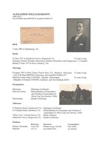 Ringwood and District Historical Society
Document - Biography - Family Tree Extract, Alexander William Brown (1885-1957) - Nurseryman, Grandview Grove Ringwood (Warranwood) Vic
A4 folder containing genealogical information, copy of will and copy of probate administration record including real estate assets for A.W. Brown, Grandview Grove Ringwood (Warranwood) Vic.EXTRACT: Inventory of Real Estate Assets (for Probate purposes) 1. Grandview Grove, Ringwood Land containing 10 acres or thereabouts situate in Grandview Grove Ringwood being part of Crown Section 20 Parish of Warrandyte County of Evelyn and being the land described in Certificate of Title Volume 5781 Folio 174 on which is erected a 7 room house, a bungalow, shed and 2 glass houses valued by E. Miles, Ringwood - £5077-0-0 2. Kardinia Crescent, Ringwood Land containing 2 acres 3 roods 24-1/2 perches situate in Kardinia Crescent Ringwood being Lots 33 and 34 on Plan of Subdivision Number 12040 and being part of Crown Section 20 Parish of Warrandyte County of Evelyn and being the land described in Certificate of Title Volume 7141 Folio 080 valued by E. Miles at £350-0-0 -
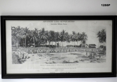 Bendigo Military Museum
Photograph - PHOTOGRAPH, FRAMED, AUGUST 16 TH 1945
PHOTOGRAPH OF A PARADE AUGUST 16TH 1945Photograph- copy of black and white photograph of “PARADE OG HEADQUARTERS TO COMMEMORATE THE VICTORY OVER JAPAN “. Photograph depicts troops on parade with tall palm trees in the background. Black print above and below photograph Frame-black colour paint on timber frame with cardboard back and glass front. Handwritten on back - donation information Black print on Photograph title ‘ADVANCED LAND HEADQUARTERS/AUSTRALIAN MILITARY FORCES “ Below photograph “PARADE OF HEADQUARTERS TO COMMEMORATE THE VICTORY OVER JAPAN/ MOROTAI AUGUST 16 TH 1945photograpy - photographs-frame accessories, ww2