Showing 123970 items matching "main-road"
-
 Stawell Historical Society Inc
Archive, S. Isaacson Store Main Street Stawell. Daily Sales Book, 1888 - 1889
Green naterial cover with red binding on spine and outer corner's. Label mostly missing Legible Print reads From S.ISAACS Family Draper Silk Mercer a From Feb MAIN stawell, business -
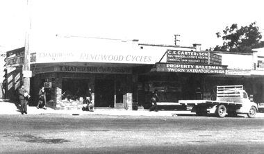 Ringwood and District Historical Society
Photograph, Main Street Ringwood, T. Mathieson Cycles on corner of station entrance, C.E. Carter to right. c1950
Black and white photograph (2 copies)Written on rear of backing sheet: "Main St. Ringwood. Ringwood Cycles now site of Commercial Banking Company of Sydney." -
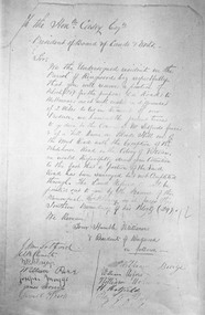 Ringwood and District Historical Society
Photograph, Petition 4/9/1872 for road to Melbourne from "Blood's Hill" (eventual corner of Bedford Road and Dublin Road, Ringwood East). Canterbury Road was later extended as a result of the petition
Catalogue card reads, 'Petition 4/9/1872 "for road to Melbourne". -
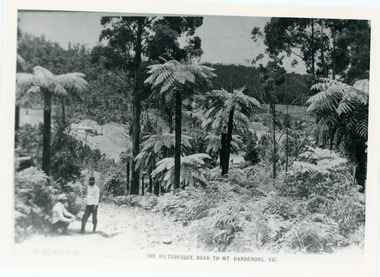 Mt Dandenong & District Historical Society Inc.
Photograph, View From Doughty's Road 1913
Mt Calvin, the homestead of Jeanie and Willie Richardson can be clearly seen in the clearing above the men in the picture. The white roof of the Barber homestead is on the right of the picture. A landslide in 1934 destroyed the tree ferned area. John Lundy-Clarke grew up in the Kalorama/Mt Dandenong area and later in life (1972-74) began to write a comprehensive history of the area working from an original settlement map in an effort to cover all areas.Black and white photograph that is a copy of a Rose series postcard titled 'The Picturesque Road to Mt. Dandenong. Vic.' It shows two men (probably Rose Series employees), one sitting and one standing at the edge of an unmade road. Large tree ferns line the roadside. Handwritten inscription on reverse by John Lundy-Clarke1913 View east from Doughty’s Road showing Jeannie Richardson’s home through the gap in the trees. A little to the right of and below centre of picture can be seen George Barber’s home with Barbers Road turning around the wagon shed that was a little up the hill from the house. The tree ferns in the picture were destroyed in the landslide of 1934. In the distance at the right can be seen F.M. Childs Homestead complex with the Richardson paddocks beyond it.mt calvin, jeanie richardson, willie richardson, george barber, landslide, tree fern -
 Greensborough Historical Society
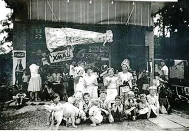
Photograph - Digital Image, Greenhills Road shop 1950s - children eating ice cream, 1950s
Local children at Christmas party at shop in Greenhill Road Greensborough. In this photo the children are eating ice creams. This shop has had many tenants and is currently the "Clay Oven" restaurant.Digital copy of black and white photograph.greenhill road -
 Greensborough Historical Society
Photograph - Digital Image, Greenhills Road shop 1960, 1950s
Local children at Christmas party at shop in Greenhill Road Greensborough. This was the first Christmas that the shop was open 1960. This shop has had many tenants and in 2016 is the "Clay Oven" restaurant.Digital copy of black and white photograph. clay oven restaurant, dobells, greenhill road -
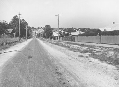 Ringwood and District Historical Society
Photograph, Warrandyte Road (unmade Road). Ringwood. (undated, probably late 1960's/early 1970's)
Written on catalogue card, "Warrandyte Road". -
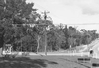 Ringwood and District Historical Society
Photograph, Intersection of Tortice Drive, Old Warrandyte Road and Warrandyte Road 1981
Written on back of photograph, "19/6/81. Intersection of Tortice Drive, Old Warrandyte Road and Warrandyte Road." -
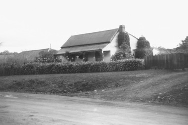 Ringwood and District Historical Society
Photograph, Old house, Old Warrandyte Road, Ringwood, nearly opposite Quamby Road, 1978
Written on back of photograph, "Old house, Old Warrandyte Road, nearly opposite Quamby Road, June 1978". -
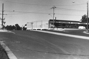 Ringwood and District Historical Society
Photograph, Intersection of Warrandyte Road and Oban Road, North Ringwood. Looking south-east. 1981
Written on back of photograph, "18/4/81. Intersection of Warrandyte Road and Oban Road. Looking south-east". -
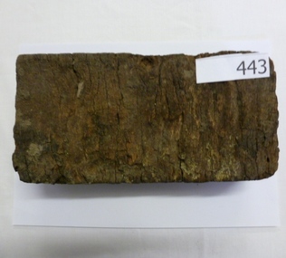 Greensborough Historical Society
Brick, Wooden road block, 1880s
Accompanied by article by Kevin Patterson (Nillumbik Historical Society) which explains the use of these blocks as a road surface in the City of Melbourne from the 1880s. The final wood blocks were dismantled in the 1950s and blocks sent to suburban wood yards to be sold as fuel for open fires and combustion heaters.As most of these blocks were sold for fuel, it is unusual to find one surviving. Block of timber cut to size and dipped in tar for use a a road block. wood blocks, paving, melbourne, road surfaces, tar -
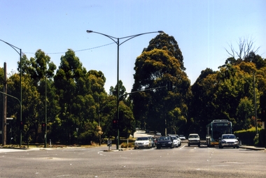 Whitehorse Historical Society Inc.
Photograph, Blackburn Road/Canterbury Road, Blackburn South, 2012
See NP4006Coloured photograph of Blackburn Road/Canterbury Road intersection. Cars coming from Blackburn - 2012blackburn road, blackburn south, canterbury road -
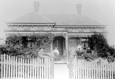
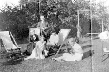 Surrey Hills Historical Society Collection
Photograph, Sunday afternoon at 'Dalriada' 77 Union Road, Surrey Hills
‘Dalriada’” at 77 Union Road, on the corner Bona Vista Avenue has been demolished. It was the home of Mr Charles Henri Dillon Steele, a dentist of Collins Street, his wife Sarah (nee Russell) and daughters Harriette Vevers (Hattie) and Margaret Dillon (Nancy). They are pictured with grandmother Mrs Sarah Ann Vevers Russell (nee Lasslett), who with her husband Alexander lived at 'Clifton', Union Road, Surrey Hills from prior to 1903. He died in 1903 at Clifton. She was still living there in 1919. A black and white photograph of a group of people in their garden, enjoying the sun. The man is standing, two older ladies are sitting on deck chairs and the two younger girls are sitting on the grass playing with a kitten.(mr) charles steele, dalriada, house names, surrey hills, bona vista avenue, (mrs) sarah steele, clothing and dress, union road, (miss) harriette vevers steele, (miss) hattie steele, (miss) nancy steele, (miss) margaret dillon steele, (mrs) sarah ann vevers russell -
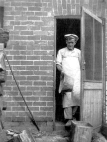 Surrey Hills Historical Society Collection
Photograph, Donald Hartley Rowe at his bakery at 118 Union Road, Surrey Hills
The photo is of Donald Hartley Rowe who was a baker at 118 Union Road. The property's rear exited on to Stirling Crescent and this photo was probably taken from kerbside of it. He was born in 1876; married Mary Gibson in 1901 and died in Surrey Hills in 1958. In 1935 his daughter Winifred (1903-1985) married Phillip Sebastien Slavin (1907-1980), known as Paddy, who took over the business. He is first listed at 118 Union Road (no occupation noted) in the electoral roll of 1937 through until 1963.A black and white photograph of a baker, dressed in pants and shirt and wearing a white apron and a light coloured cook's flat cap coming out of a doorway. He has a large tin dish in his right hand.baker, union road, surrey hills, (mr) donald hartley rowe, (miss) winifred rowe, (mrs) winifred slavin, (mr) phillip sebastien slavin, (mr) paddy slavin -
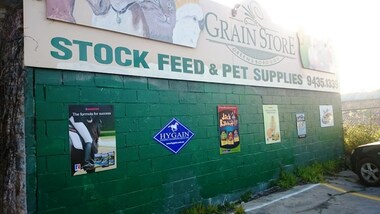 Greensborough Historical Society
Photograph - Digital Image, Marilyn Smith, Greensborough Grain Store, 183 Para Road, 06/08/2016
This photograph shows the exterior of the building at 183 Para Road when it was used for Greensborough Grain Store; this photo was taken in August 2016, shortly after the owners removed graffiti from the building.In 2017, the Greensborough Grain Store closed its Para Road premises and now trades online.Digital copy of colour photographgreensborough grain store, para road greensborough, graffiti -
 Surrey Hills Historical Society Collection
Photograph, "Braemar" 18 Suffolk Road, Surrey Hills
"Braemar" at 18 Suffolk Road, Surrey Hills - built c1894, demolished in1977 – and home of James Sneddon Snr. and family from 1890 until c1950. We believe it is James is at the gate and his family on the veranda. James was born in Alloa, Clackmannanshire Scotland in 1833, as was his wife Jane. He died in March 1901 and she in March 1911. They are buried in Boroondara Cemetery (Pres B0522) with their daughter Jane (1864-1928). James Sneddon (Snr) was an important man in early Surrey Hills. He established real estate and ironmongery businesses in Union Road – first on the corner of Stirling Crescent and later over the road on the corner of Windsor Crescent. He was chairman of Surrey Hills’ MUIOOF (Manchester Unity Independent Order of Oddfellows). James Sneddon Jnr. followed his father in the family real estate business and was an even busier community man. He was a JP and had roles in the Surrey Hills ANA, the Progress Association and the Choral Society. He lived 2 doors from his father. The real estate business continued on the corner of Windsor Crescent and Union Road (north side) until the business was sold to the Doubleday (family) after WW2.The Sneddon family were early settlers and business owners in Surrey Hills and remained over 3 generations. Different family members held many roles in community organisations. This photo is also important in documenting built heritage that has been demolished.Image of a Victorian, weatherboard, block fronted, single storey house with decorative veranda, viewed from the front. The garden in front of the house is well established and a light-coloured picket fence surrounds the property. Four people are in the photograph, three women (two seated and one standing) on the veranda and one male, who is leaning against the gate post.buildings, structures and establishments, houses, timber houses, house names, braemar, architectural styles, victorian style, families, family group, sneddon family, james sneddon (snr), boroondara cemetery, real estate agent, ironmonger -
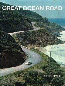 Otway Districts Historical Society
Book, Rigby Limited, Great Ocean Road. K.G. Stepnell, 1972
The Great Ocean Road may be the only road in the world which was built as a war memorial. In 1916, much of Australia was poorly served by roads, and it was suggested that returning servicemen could be given worthwhile employment by building roads in isolated areas. The plan was taken up for the Great Ocean Road, and work was dedicated to the memory of men who had fallen in World War 1. The road itself is a great feat of engineering. It wind around some of Australia's most rugged coastline. Now it is one of the world's most scenic routes, crossing gorges, along precipitous cliffs, through dense forests, and over steeply rolling coastline country.Great Ocean Road. K.G. Stepnell. 1st ed. Rigby Limited; Adelaide (S.A.); 1972. 36 p.; illus., maps. Hard cover. ISBN 0 85179 371 1great ocean road; roads; fishing; timber; twelve apostles; -
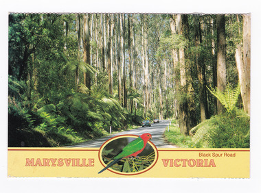
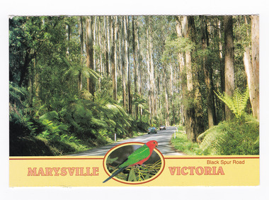 Marysville & District Historical Society
Postcard (item) - Colour postcard, Neil Cutts, Marysville Victoria-Black Spur Road, Pre 2009
A postcard in a series produced by the Rose Stereograph Company in Victoria, Australia as a souvenir of Marysville.A colour photograph of the Black Spur Road near Marysville in Victoria. The Black Spur is known to be one of Victoria's most scenic drives. The road winds through a majestic forest of trees and tree ferns from Healesville to Narbethong and is part of the Maroondah Highway. Rose Series postcard No. 3528. POST CARD The "Rose" Series/ De Luxe Proudly Printed in/ Australia Since 1880 AFFIX/ STAMP/ HERE/ Rose Series/ Post Card No./ 3528 ADDRESS/ POSTCODE Mountain Ash and Treeferns/ Black Spur Road/ MARYSVILLE, VICTORIA, AUSTRALIA/ Photo Neil Cutts Copyright Rose Stereograph Co., Glen Waverley, Victoria (03) 9560 7772marysville, victoria, black spur road, postcard, souvenir, rose series postcard, 3528, healesville, narbethong, maroondah highway -
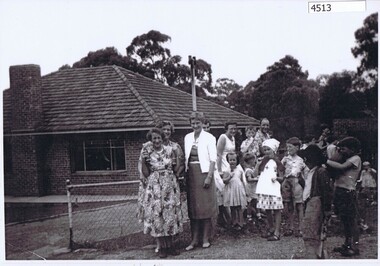 Greensborough Historical Society
Photograph (copy), Family group, Greenhill Road Greensborough, 1958c
Family group, including Granny Andersen (far left), daughter Dot Turner (3rd from left) and daughter June Thorp (5th from left). Photograph taken in Greenhill Road Greensborough.Black & white photograph, enlarged and laminated.granny andersen, dot turner, june thorp, greenhill road greensborough -
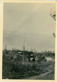 Mt Dandenong & District Historical Society Inc.
Photograph, View From Range Road, Olinda. 1909, 1909
1909 view of Olinda showing 'Charlemont' guest house and the Olinda school on the skyline above Dodd's stables. Range Road (The Bullock Track) is in the foireground. The descriptive text on the reverse of this photograph was hand written by John Lundy-Clarke.1909 view of Olinda from Range Road (The Bullock Track). Showing school on skyline above Dodd’s stables with “Charlemont” on left.charlemont guest house, dodd, dodd's stables, stables, olinda, olinda school, range road, bullock track -
 Eltham District Historical Society Inc
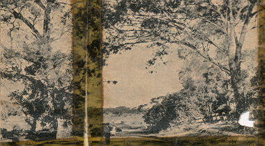
Newspaper clipping, 1. A peep on the road, nearing Research.; New Railway Line: Eltham to Hurst's Bridge; The Weekly Times, 24 Feb 1912, p27, 1912
Pages from a scrapbook belonging to Heather Jenkins (nee Sargeant) who lived as a child in the Police Residence at 728 Main Road, Eltham in the 1920s. Images featured are 1. A peep on the road, nearing Research. 2. The Main Road at Eltham (opposite Railway Station). 3. A part of the new railway line. 4. The mail coach leaving for Kangaroo Ground.Heather Sargeant was the daughter of Constable W.C. Sargeant, the local police officer in residence at Eltham, 1922-1927Detail from large newspaper clipping (half page), very aged and fragile with sticky tape holding it together with 4 images of early Elthameltham, heather jenkins (nee sargeant), main road, research (vic.) -
 Eltham District Historical Society Inc
Newspaper clipping, 1. A peep on the road, nearing Research.; New Railway Line: Eltham to Hurst's Bridge; The Weekly Times, 24 Feb 1912, p27, 1912
Pages from a scrapbook belonging to Heather Jenkins (nee Sargeant) who lived as a child in the Police Residence at 728 Main Road, Eltham in the 1920s. Images featured are 1. A peep on the road, nearing Research. 2. The Main Road at Eltham (opposite Railway Station). 3. A part of the new railway line. 4. The mail coach leaving for Kangaroo Ground.Heather Sargeant was the daughter of Constable W.C. Sargeant, the local police officer in residence at Eltham, 1922-1927Large newspaper clipping (half page), very aged and fragile with sticky tape holding it together with 4 images of early Elthameltham, heather jenkins (nee sargeant), main road, eltham railway station -
 Eltham District Historical Society Inc
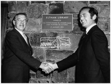
Photograph, Opening of Eltham Library, 17 Aug 1971
Official opening of Eltham Library; The Hon. Rupert. J. Hamer, E.D., M.P. (left) and Cr. G.C. Dreverman (right), 17 August 1971, in front of a plaque reading "Eltham Library opened by the Honourable R. J. Hamer E.D., M.P. Chief Secretary of Victoria, 17 August 1971" on the exterior bluestone wall. The Eltham Branch of the Heidelberg Regional Library Service was opened on 17 August 1971 by Victoria’s Chief Secretary R. J. Hamer. The library was designed by the firm Leith and Bartlett and was the southern wing of the Shire of Eltham Offices in Main Road Eltham. Visitors entered a “book plaza” which embodies the display techniques of a bookshop. Through this area was located a quieter area for reference and the more “purposeful” reader. The library was opened as part of the Shire of Eltham’s centenary celebrations. The library and Shire Offices were demolished exactly 25 years later in 1996. The current library was opened in 1994. This photo forms part of a collection of photographs gathered by the Shire of Eltham for their centenary project book, "Pioneers and Painters: 100 years of the Shire of Eltham" by Alan Marshall (1971). The collection of over 500 images is held in partnership between Eltham District Historical Society and Yarra Plenty Regional Library (Eltham Library) and is now formally known as 'The Shire of Eltham Pioneers Photograph Collection.' It is significant in being the first community sourced collection representing the places and people of the Shire's first one hundred years.Digital imagesepp, shire of eltham pioneers photograph collection, shire of eltham, shire of eltham centenary, eltham library, opening day, cr. g.c. dreverman, the hon. r.j. hamer -
 Phillip Island and District Historical Society Inc.
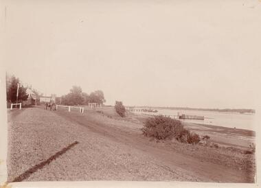
Photograph, San Remo beach road
From Jessie Smith's collection showing road along foreshore and small Jetties.Sepia print. Gravel road at left - Beach front with low scrub and little Jetties at middle and right. Horse tethered at left middle."Old Coal Jetty - San Remo" - written on back.local history, photographs, foreshore san remo, sepia photograph, jessie smith collection, stan mcfee -
 Federation University Historical Collection
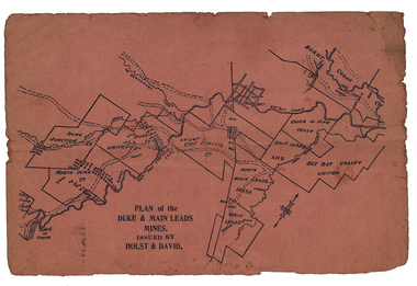
Plan, Plan of the Duke and Main Leads Mines, Issued by Holst and David
Small, pink page showing the Duke and Main Leads Mines, including Duke Junction, North Duke Co, Duke United Ci, Lord Roberts Co, North Man Leads Lease, Main Leads, Bet Bet Valley United, Duke and Fifle Lease, Burnt Creek, Great Duke Lease, Timor. On verso are two advertisements including one for J. Hillman (includes image), and John R. Harrisonj. hillman, mining and engineering smith, adze-eye pick, hillman pick, ballarat pick, safety cage, john r harrison, engineering, cgt, duke and main leads mines, duke junction, north duke co, duke united co, lord roberts co, north main leads lease, main leads, bet bet valley united, duke and fife lease, burnt creek, great duke lease, timor., stockbrokers, holst and david -
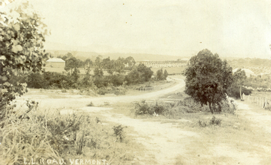 Whitehorse Historical Society Inc.
Photograph, L L Road Vermont, late 1800
Dr L L Smith was a pioneer of the Vermont District. He owned 250 acres in the area bounded by Boronia, Canterbury and Heatherdale Roads and the creek. The property was known as L L Vale after which the road was named. Name was changed to Boronia Road in later years. He was a Doctor with rooms in the City, was a member of Parliament.Sepia Postcard of L L Road, Vermont (now Boronia Road) taken in the early 1900s (card is postmarked 27 Aug 1909). Shows the road going down it is presumed to the creek. It is possible that the house is that of Dr.L.L.Smith. See History.|Orchard in background is the Finger orchard. (from Mr. Shambrook - Tim's father)|Information on the back of the Postcard reveal it was sent to Miss Roberts of 61 Hoddle Street Richmond Victoria by Muriel at 37 Victoria Road Northcote and was posted at the Fairfield Post Office Victoria on 27 August 1909. Text is 'Dear Ethel Just a Post Card to let you know I will be out to see you on Monday if convenient. I came down with Mr Hutchinson and he asked me what were we laughing out on the Sunday when he came up. Muriel|See the following references -ND199, 313, 539. 1242, 2013, 3680 & 4295.l l road vermont, boronia road vermont, smith . l l dr -
 Eltham District Historical Society Inc
Photograph, Liz Pidgeon, Heritage Excursion; East of Eltham, 6 Sep 2014, 20 May 2017
Newsletter No. 218, September 2014 September Excursion - East of Eltham Walk In Newsletter No. 197, March 2011, there was a brief history of Crown Allotment 15 Section 5 Parish of Nillumbik (CA 15) a parcel of land of a quarter of a square mile extending from Eucalyptus Road to Reynolds Road at the eastern extremity of Eltham. From the 1940s it was known as Stokes orchard. In later years it has been subdivided for residential purposes but leaving significant areas as power line and water supply reserves and bushland reserves that are habitat for the threatened For our excursion on 6th September we intend to walk through CA 15 to a bushland reserve east of Reynolds Road. The walk will traverse the boundary between suburban Eltham and the non-urban areas to the south and east. This is a pleasant walk through residential areas and bushland. Along the way we will discuss the early and more recent history of CA 15 as well as local natural history and geology. This walk is about 3.5 km in length and will take 2 to 2.5 hours. It will start at 2pm at the corner of Eucalyptus Road, Pitt Street and Nyora Road.Born Digitaleltham east, eltham district historical society, heritage excursion, activities, nyora road, reynolds road, gum tree road reserve, diosma road, stokes orchard, eucalyptus road -
 Eltham District Historical Society Inc
Photograph, Liz Pidgeon, Heritage Excursion; East of Eltham, 6 Sep 2014, 20 May 2017
Newsletter No. 218, September 2014 September Excursion - East of Eltham Walk In Newsletter No. 197, March 2011, there was a brief history of Crown Allotment 15 Section 5 Parish of Nillumbik (CA 15) a parcel of land of a quarter of a square mile extending from Eucalyptus Road to Reynolds Road at the eastern extremity of Eltham. From the 1940s it was known as Stokes orchard. In later years it has been subdivided for residential purposes but leaving significant areas as power line and water supply reserves and bushland reserves that are habitat for the threatened For our excursion on 6th September we intend to walk through CA 15 to a bushland reserve east of Reynolds Road. The walk will traverse the boundary between suburban Eltham and the non-urban areas to the south and east. This is a pleasant walk through residential areas and bushland. Along the way we will discuss the early and more recent history of CA 15 as well as local natural history and geology. This walk is about 3.5 km in length and will take 2 to 2.5 hours. It will start at 2pm at the corner of Eucalyptus Road, Pitt Street and Nyora Road.Born Digitaleltham east, eltham district historical society, heritage excursion, activities, nyora road, reynolds road, gum tree road reserve, diosma road, stokes orchard, eucalyptus road