Showing 3971 items matching "newsletters"
-
 Eltham District Historical Society Inc
Photograph, Liz Pidgeon, Heritage Excursion; Maroondah Aqueduct, 3 September 2016, 3 September 2016
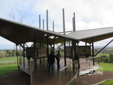
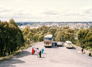
Newsletter No., 229, August 2016 Heritage Excursion - Maroondah Aqueduct Walk - Saturday 3rd September The Maroondah Aqueduct was once a major link in Melbourne’s water supply system. It was built between 1886 and 1891 to transfer water from the Watts River near Healesville to the Preston Reservoir. It was 66 km in length, made up of 41 km of open channel, 10 km of tunnel through hills and 15 km of pipeline across stream valleys known as inverted siphons. The section of the aqueduct through the Eltham area has been abandoned since the 1980s but the open channel has largely been retained. A recreational path follows the aqueduct reserve. For our excursion on 3rd September we intend to walk along the section of the aqueduct adjacent to Allendale Road. This is a section not visited on previous excursions and includes the transition from open channel to the inverted siphon across the Diamond Creek valley. Apart from the aqueduct itself the main feature of the walk is the extensive views across Eltham North and Diamond Creek. Along the way we will talk about the history of the aqueduct and the area. This easy walk is about 3 km return and will take 2 to 2.5 hours. It will start at 2pm at the junction of Allendale Road with Godber Road and Zig Zag Road North, officially Diamond Creek, but on the northern boundary of Eltham. (Melway ref.12 B10). Born Digitalmaroondah aqueduct, eltham north, activities, eltham district historical society, heritage excursion, aqueduct trail, open channel -
 Eltham District Historical Society Inc
Photograph, Liz Pidgeon, Heritage Excursion; Maroondah Aqueduct, 3 September 2016, 3 September 2016
Newsletter No., 229, August 2016 Heritage Excursion - Maroondah Aqueduct Walk - Saturday 3rd September The Maroondah Aqueduct was once a major link in Melbourne’s water supply system. It was built between 1886 and 1891 to transfer water from the Watts River near Healesville to the Preston Reservoir. It was 66 km in length, made up of 41 km of open channel, 10 km of tunnel through hills and 15 km of pipeline across stream valleys known as inverted siphons. The section of the aqueduct through the Eltham area has been abandoned since the 1980s but the open channel has largely been retained. A recreational path follows the aqueduct reserve. For our excursion on 3rd September we intend to walk along the section of the aqueduct adjacent to Allendale Road. This is a section not visited on previous excursions and includes the transition from open channel to the inverted siphon across the Diamond Creek valley. Apart from the aqueduct itself the main feature of the walk is the extensive views across Eltham North and Diamond Creek. Along the way we will talk about the history of the aqueduct and the area. This easy walk is about 3 km return and will take 2 to 2.5 hours. It will start at 2pm at the junction of Allendale Road with Godber Road and Zig Zag Road North, officially Diamond Creek, but on the northern boundary of Eltham. (Melway ref.12 B10). Born Digitalmaroondah aqueduct, eltham north, activities, eltham district historical society, heritage excursion, aqueduct trail -
 Eltham District Historical Society Inc
Photograph, Liz Pidgeon, Heritage Excursion; Maroondah Aqueduct, 3 September 2016, 3 September 2016
Newsletter No., 229, August 2016 Heritage Excursion - Maroondah Aqueduct Walk - Saturday 3rd September The Maroondah Aqueduct was once a major link in Melbourne’s water supply system. It was built between 1886 and 1891 to transfer water from the Watts River near Healesville to the Preston Reservoir. It was 66 km in length, made up of 41 km of open channel, 10 km of tunnel through hills and 15 km of pipeline across stream valleys known as inverted siphons. The section of the aqueduct through the Eltham area has been abandoned since the 1980s but the open channel has largely been retained. A recreational path follows the aqueduct reserve. For our excursion on 3rd September we intend to walk along the section of the aqueduct adjacent to Allendale Road. This is a section not visited on previous excursions and includes the transition from open channel to the inverted siphon across the Diamond Creek valley. Apart from the aqueduct itself the main feature of the walk is the extensive views across Eltham North and Diamond Creek. Along the way we will talk about the history of the aqueduct and the area. This easy walk is about 3 km return and will take 2 to 2.5 hours. It will start at 2pm at the junction of Allendale Road with Godber Road and Zig Zag Road North, officially Diamond Creek, but on the northern boundary of Eltham. (Melway ref.12 B10). Born Digitalmaroondah aqueduct, eltham north, activities, eltham district historical society, heritage excursion, aqueduct trail, open channel, pipe -
 Eltham District Historical Society Inc
Photograph, Liz Pidgeon, Heritage Excursion; Maroondah Aqueduct, 3 September 2016, 3 September 2016
Newsletter No., 229, August 2016 Heritage Excursion - Maroondah Aqueduct Walk - Saturday 3rd September The Maroondah Aqueduct was once a major link in Melbourne’s water supply system. It was built between 1886 and 1891 to transfer water from the Watts River near Healesville to the Preston Reservoir. It was 66 km in length, made up of 41 km of open channel, 10 km of tunnel through hills and 15 km of pipeline across stream valleys known as inverted siphons. The section of the aqueduct through the Eltham area has been abandoned since the 1980s but the open channel has largely been retained. A recreational path follows the aqueduct reserve. For our excursion on 3rd September we intend to walk along the section of the aqueduct adjacent to Allendale Road. This is a section not visited on previous excursions and includes the transition from open channel to the inverted siphon across the Diamond Creek valley. Apart from the aqueduct itself the main feature of the walk is the extensive views across Eltham North and Diamond Creek. Along the way we will talk about the history of the aqueduct and the area. This easy walk is about 3 km return and will take 2 to 2.5 hours. It will start at 2pm at the junction of Allendale Road with Godber Road and Zig Zag Road North, officially Diamond Creek, but on the northern boundary of Eltham. (Melway ref.12 B10). Born Digitalmaroondah aqueduct, eltham north, activities, eltham district historical society, heritage excursion, aqueduct trail -
 Eltham District Historical Society Inc
Photograph, Liz Pidgeon, Heritage Excursion; Maroondah Aqueduct, 3 September 2016, 3 September 2016
Newsletter No., 229, August 2016 Heritage Excursion - Maroondah Aqueduct Walk - Saturday 3rd September The Maroondah Aqueduct was once a major link in Melbourne’s water supply system. It was built between 1886 and 1891 to transfer water from the Watts River near Healesville to the Preston Reservoir. It was 66 km in length, made up of 41 km of open channel, 10 km of tunnel through hills and 15 km of pipeline across stream valleys known as inverted siphons. The section of the aqueduct through the Eltham area has been abandoned since the 1980s but the open channel has largely been retained. A recreational path follows the aqueduct reserve. For our excursion on 3rd September we intend to walk along the section of the aqueduct adjacent to Allendale Road. This is a section not visited on previous excursions and includes the transition from open channel to the inverted siphon across the Diamond Creek valley. Apart from the aqueduct itself the main feature of the walk is the extensive views across Eltham North and Diamond Creek. Along the way we will talk about the history of the aqueduct and the area. This easy walk is about 3 km return and will take 2 to 2.5 hours. It will start at 2pm at the junction of Allendale Road with Godber Road and Zig Zag Road North, officially Diamond Creek, but on the northern boundary of Eltham. (Melway ref.12 B10). Born Digitalmaroondah aqueduct, eltham north, activities, eltham district historical society, heritage excursion, aqueduct trail, russell yeoman -
 Eltham District Historical Society Inc
Photograph, Liz Pidgeon, Heritage Excursion; Maroondah Aqueduct, 3 September 2016, 3 September 2016
Newsletter No., 229, August 2016 Heritage Excursion - Maroondah Aqueduct Walk - Saturday 3rd September The Maroondah Aqueduct was once a major link in Melbourne’s water supply system. It was built between 1886 and 1891 to transfer water from the Watts River near Healesville to the Preston Reservoir. It was 66 km in length, made up of 41 km of open channel, 10 km of tunnel through hills and 15 km of pipeline across stream valleys known as inverted siphons. The section of the aqueduct through the Eltham area has been abandoned since the 1980s but the open channel has largely been retained. A recreational path follows the aqueduct reserve. For our excursion on 3rd September we intend to walk along the section of the aqueduct adjacent to Allendale Road. This is a section not visited on previous excursions and includes the transition from open channel to the inverted siphon across the Diamond Creek valley. Apart from the aqueduct itself the main feature of the walk is the extensive views across Eltham North and Diamond Creek. Along the way we will talk about the history of the aqueduct and the area. This easy walk is about 3 km return and will take 2 to 2.5 hours. It will start at 2pm at the junction of Allendale Road with Godber Road and Zig Zag Road North, officially Diamond Creek, but on the northern boundary of Eltham. (Melway ref.12 B10). Born Digitalmaroondah aqueduct, eltham north, activities, eltham district historical society, heritage excursion, aqueduct trail -
 Eltham District Historical Society Inc
Photograph, Liz Pidgeon, Heritage Excursion; Maroondah Aqueduct, 3 September 2016, 3 September 2016
Newsletter No., 229, August 2016 Heritage Excursion - Maroondah Aqueduct Walk - Saturday 3rd September The Maroondah Aqueduct was once a major link in Melbourne’s water supply system. It was built between 1886 and 1891 to transfer water from the Watts River near Healesville to the Preston Reservoir. It was 66 km in length, made up of 41 km of open channel, 10 km of tunnel through hills and 15 km of pipeline across stream valleys known as inverted siphons. The section of the aqueduct through the Eltham area has been abandoned since the 1980s but the open channel has largely been retained. A recreational path follows the aqueduct reserve. For our excursion on 3rd September we intend to walk along the section of the aqueduct adjacent to Allendale Road. This is a section not visited on previous excursions and includes the transition from open channel to the inverted siphon across the Diamond Creek valley. Apart from the aqueduct itself the main feature of the walk is the extensive views across Eltham North and Diamond Creek. Along the way we will talk about the history of the aqueduct and the area. This easy walk is about 3 km return and will take 2 to 2.5 hours. It will start at 2pm at the junction of Allendale Road with Godber Road and Zig Zag Road North, officially Diamond Creek, but on the northern boundary of Eltham. (Melway ref.12 B10). Born Digitalmaroondah aqueduct, eltham north, activities, eltham district historical society, heritage excursion, aqueduct trail, open channel -
 Eltham District Historical Society Inc
Photograph, Liz Pidgeon, Heritage Excursion; Maroondah Aqueduct, 3 September 2016, 3 September 2016
Newsletter No., 229, August 2016 Heritage Excursion - Maroondah Aqueduct Walk - Saturday 3rd September The Maroondah Aqueduct was once a major link in Melbourne’s water supply system. It was built between 1886 and 1891 to transfer water from the Watts River near Healesville to the Preston Reservoir. It was 66 km in length, made up of 41 km of open channel, 10 km of tunnel through hills and 15 km of pipeline across stream valleys known as inverted siphons. The section of the aqueduct through the Eltham area has been abandoned since the 1980s but the open channel has largely been retained. A recreational path follows the aqueduct reserve. For our excursion on 3rd September we intend to walk along the section of the aqueduct adjacent to Allendale Road. This is a section not visited on previous excursions and includes the transition from open channel to the inverted siphon across the Diamond Creek valley. Apart from the aqueduct itself the main feature of the walk is the extensive views across Eltham North and Diamond Creek. Along the way we will talk about the history of the aqueduct and the area. This easy walk is about 3 km return and will take 2 to 2.5 hours. It will start at 2pm at the junction of Allendale Road with Godber Road and Zig Zag Road North, officially Diamond Creek, but on the northern boundary of Eltham. (Melway ref.12 B10). Born Digitalmaroondah aqueduct, eltham north, activities, eltham district historical society, heritage excursion -
 Eltham District Historical Society Inc
Photograph, Liz Pidgeon, Heritage Excursion; Maroondah Aqueduct, 3 September 2016, 3 September 2016
Newsletter No., 229, August 2016 Heritage Excursion - Maroondah Aqueduct Walk - Saturday 3rd September The Maroondah Aqueduct was once a major link in Melbourne’s water supply system. It was built between 1886 and 1891 to transfer water from the Watts River near Healesville to the Preston Reservoir. It was 66 km in length, made up of 41 km of open channel, 10 km of tunnel through hills and 15 km of pipeline across stream valleys known as inverted siphons. The section of the aqueduct through the Eltham area has been abandoned since the 1980s but the open channel has largely been retained. A recreational path follows the aqueduct reserve. For our excursion on 3rd September we intend to walk along the section of the aqueduct adjacent to Allendale Road. This is a section not visited on previous excursions and includes the transition from open channel to the inverted siphon across the Diamond Creek valley. Apart from the aqueduct itself the main feature of the walk is the extensive views across Eltham North and Diamond Creek. Along the way we will talk about the history of the aqueduct and the area. This easy walk is about 3 km return and will take 2 to 2.5 hours. It will start at 2pm at the junction of Allendale Road with Godber Road and Zig Zag Road North, officially Diamond Creek, but on the northern boundary of Eltham. (Melway ref.12 B10). Born Digitalmaroondah aqueduct, eltham north, activities, eltham district historical society, heritage excursion, aqueduct trail -
 Eltham District Historical Society Inc
Photograph, Liz Pidgeon, Heritage Excursion; Maroondah Aqueduct, 3 September 2016, 3 September 2016
Newsletter No., 229, August 2016 Heritage Excursion - Maroondah Aqueduct Walk - Saturday 3rd September The Maroondah Aqueduct was once a major link in Melbourne’s water supply system. It was built between 1886 and 1891 to transfer water from the Watts River near Healesville to the Preston Reservoir. It was 66 km in length, made up of 41 km of open channel, 10 km of tunnel through hills and 15 km of pipeline across stream valleys known as inverted siphons. The section of the aqueduct through the Eltham area has been abandoned since the 1980s but the open channel has largely been retained. A recreational path follows the aqueduct reserve. For our excursion on 3rd September we intend to walk along the section of the aqueduct adjacent to Allendale Road. This is a section not visited on previous excursions and includes the transition from open channel to the inverted siphon across the Diamond Creek valley. Apart from the aqueduct itself the main feature of the walk is the extensive views across Eltham North and Diamond Creek. Along the way we will talk about the history of the aqueduct and the area. This easy walk is about 3 km return and will take 2 to 2.5 hours. It will start at 2pm at the junction of Allendale Road with Godber Road and Zig Zag Road North, officially Diamond Creek, but on the northern boundary of Eltham. (Melway ref.12 B10). Born Digitalmaroondah aqueduct, eltham north, activities, eltham district historical society, heritage excursion, aqueduct trail -
 Eltham District Historical Society Inc
Photograph, Liz Pidgeon, Moor-Rul Viewing Platform, 10 August 2016
The Moor-Rul Viewing Platform, part of the Kangaroo Ground War Memorial Park opened in April 2007. Eight double-sided interpretation panels on the Moor-rul viewing platform highlight the area's Aboriginal and European history of the area and also details of local geology, flora and fauna. These panels feature high quality graphic design and professionally written text. The subjects covered are: ''Womin Je Ka" Welcome The Kulin Nation Singing, Dancing, Ceremony, Celebration This Country, My Home The Highland Taken Auld Lang Syne "Same Land Different Views" Working the Land Food from the Earth or "Earth's Harvest" Lest We Forget, "And with the going down of the Sun .... (3 panels) This Black Earth Those other indigenous inhabitants - Kangaroo Ground's Wildlife Silent Witnesses - Kangaroo Ground's White Manna Gums Belonging A Place of Reverence and A Tower of Strength Souce: EDHS Newsletter No 173 March 2007. As part of a program to acknowledge the Anzac Centenary Nillumbik Shire Council partnered with Yarra Plenty Regional Library to provide a bus tour with commentary of local sites of significance: Shire of Nillumbik World War One Memorials tour, 10 August 2016. These included Eltham township, the Shire of Eltham War Memorial at Kangaroo Ground, Christmas Hills war memorial, Hurstbridge memorial recreation park and finshed at Eltham Library to view the Writing the War exhibtion at Eltham Library Community Gallery.Born Digitalshire of nillumbik, moor-rul viewing platform, kangaroo ground -
 Eltham District Historical Society Inc
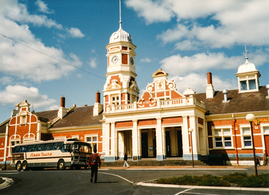
Photograph, Doug Orford, Maryborough Railway Station, Spring Excursion to Maryborough, 27 September 1992, 27/09/1992
[from EDHS Newsletter No. 86, September 1992:] SPRING EXCURSION MARYBOROUGH: As a Spring excursion our bus trip on 27th September is well timed - Maryborough is conducting its Wattle Festival on that weekend. We are to be guests of the Midlands Historical Society who will provide a guide for our tour of the town. This is a somewhat longer trip than we usually undertake so we have an earlier start at 8.00 am and the cost is a little more than usual at $20.00. The entry to the Midlands Society's Worsley Cottage is included. At the end of the town tour we will visit the C.W.A.'s Fair which is part of the Wattle Festival. Afternoon tea will be available there for a small charge. Bring your lunch and something for morning tea if you wish. We will be travelling to Maryborough via Creswick and Clunes and returning via Castlemaine. We will return about 6.00 pm and transport home can be arranged if required. Maryborough has a rich history with the gold era being particularly significant. Local historian Betty Osborne has produced the book "Maryborough - a Social History 1854-1905". You might like to try and obtain it from the library for advance reading or it will be available for purchase on the day at $25.00. To book for this tour please complete the attached from and return with your payment to the September meeting or send it to our post office box. Friends are most welcome as usual.Two colour photographsactivities, maryborough -
 Eltham District Historical Society Inc
Photograph, At Creswick, Spring Excursion to Maryborough, 27 September 1992, 27/09/1992
[from EDHS Newsletter No. 86, September 1992:] SPRING EXCURSION MARYBOROUGH: As a Spring excursion our bus trip on 27th September is well timed - Maryborough is conducting its Wattle Festival on that weekend. We are to be guests of the Midlands Historical Society who will provide a guide for our tour of the town. This is a somewhat longer trip than we usually undertake so we have an earlier start at 8.00 am and the cost is a little more than usual at $20.00. The entry to the Midlands Society's Worsley Cottage is included. At the end of the town tour we will visit the C.W.A.'s Fair which is part of the Wattle Festival. Afternoon tea will be available there for a small charge. Bring your lunch and something for morning tea if you wish. We will be travelling to Maryborough via Creswick and Clunes and returning via Castlemaine. We will return about 6.00 pm and transport home can be arranged if required. Maryborough has a rich history with the gold era being particularly significant. Local historian Betty Osborne has produced the book "Maryborough - a Social History 1854-1905". You might like to try and obtain it from the library for advance reading or it will be available for purchase on the day at $25.00. To book for this tour please complete the attached from and return with your payment to the September meeting or send it to our post office box. Friends are most welcome as usual.Colour photographactivities, maryborough -
 Eltham District Historical Society Inc
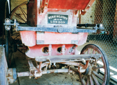
Photograph, Doug Orford, Aboriginal waterholes at Maryborough, Spring Excursion to Maryborough, 27 September 1992, 27/09/1992
[from EDHS Newsletter No. 86, September 1992:] SPRING EXCURSION MARYBOROUGH: As a Spring excursion our bus trip on 27th September is well timed - Maryborough is conducting its Wattle Festival on that weekend. We are to be guests of the Midlands Historical Society who will provide a guide for our tour of the town. This is a somewhat longer trip than we usually undertake so we have an earlier start at 8.00 am and the cost is a little more than usual at $20.00. The entry to the Midlands Society's Worsley Cottage is included. At the end of the town tour we will visit the C.W.A.'s Fair which is part of the Wattle Festival. Afternoon tea will be available there for a small charge. Bring your lunch and something for morning tea if you wish. We will be travelling to Maryborough via Creswick and Clunes and returning via Castlemaine. We will return about 6.00 pm and transport home can be arranged if required. Maryborough has a rich history with the gold era being particularly significant. Local historian Betty Osborne has produced the book "Maryborough - a Social History 1854-1905". You might like to try and obtain it from the library for advance reading or it will be available for purchase on the day at $25.00. To book for this tour please complete the attached from and return with your payment to the September meeting or send it to our post office box. Friends are most welcome as usual.Colour photographactivities, maryborough -
 Eltham District Historical Society Inc
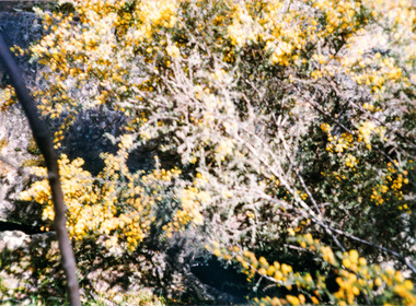
Photograph, Doug Orford, From Maryborough Lookout, Spring Excursion to Maryborough, 27 September 1992, 27/09/1992
[from EDHS Newsletter No. 86, September 1992:] SPRING EXCURSION MARYBOROUGH: As a Spring excursion our bus trip on 27th September is well timed - Maryborough is conducting its Wattle Festival on that weekend. We are to be guests of the Midlands Historical Society who will provide a guide for our tour of the town. This is a somewhat longer trip than we usually undertake so we have an earlier start at 8.00 am and the cost is a little more than usual at $20.00. The entry to the Midlands Society's Worsley Cottage is included. At the end of the town tour we will visit the C.W.A.'s Fair which is part of the Wattle Festival. Afternoon tea will be available there for a small charge. Bring your lunch and something for morning tea if you wish. We will be travelling to Maryborough via Creswick and Clunes and returning via Castlemaine. We will return about 6.00 pm and transport home can be arranged if required. Maryborough has a rich history with the gold era being particularly significant. Local historian Betty Osborne has produced the book "Maryborough - a Social History 1854-1905". You might like to try and obtain it from the library for advance reading or it will be available for purchase on the day at $25.00. To book for this tour please complete the attached from and return with your payment to the September meeting or send it to our post office box. Friends are most welcome as usual.Two colour photographsactivities, maryborough -
 Melbourne Legacy
Photograph - Photo, Junior Legacy Classes, 1953
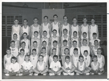
A class photo of a group of young legatees at a gymnastics class in Malvern. There are 43 boys, of various ages, in gymnastics gear. Legacy clubs ran classes for junior legatees for many years. It was part of providing for the children of their deceased comrades. The skills they learned were show cased in an annual demonstration usually at the Melbourne Town Hall. It appears to be photo taken professionally, as there are several photos of different classes (see 00862 - 00867) perhaps to record Legacy classes for promotion purposes. The photo featured in the September 1953 Newsletter. Backrow: Garry Burns, Merv Nelson, Denys Nelson, Ted Soutar, Peter Grenfell, Don McKneil, Frank Batty, Ross Moloney, Don McKean. 2nd row: John Kerlie, Ian Cameron, Dick Farnback, Norm Brown, John Farnbach, Ian Grainger, Graeme Pocknee, Frank Rutledge, Fred Strong. 3rd row: Graham Thorp, Norm Wright, Brian Scarlett, Ron Wilson, John Wright, George Brown, Alec Addison, Geroge Thorpe, Harold Boyes, 4th Row: Andrew Tonkin, Edward Pocknee, William L Brown, Max Hamilton, Ken Jacka, Don Walker, Clliff McAliece, John Brown, John Buckle. Front row: Geoff Strogeon, Richard Bowman, Dick Payne, David Triff, Ken Dean, John Clarke, Willliam Brown.A record of a way Legacy provided classes for junior legatees.Black and white photo of Legacy boys posing for a class photo.Printed on the back 'Malvern'. Stamped 'R5332/1--' and '531' in blue ink. Handwritten 'P4 Legacy' in blue pen and 'Same size' in pencil.junior legatee, boys' classes, malvern -
 Eltham District Historical Society Inc
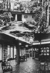
Photograph, Periwinkle House (1948); Bob and Ada Zull House (1970)
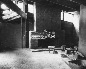
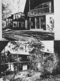
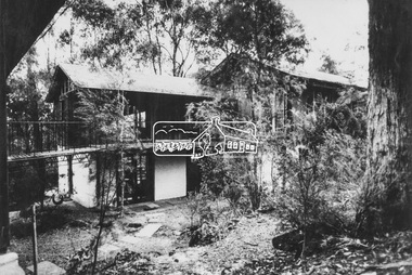
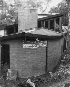
Images 9A and 9B 9A 'Periwinkle House' 1948 For Mr and Mrs J Holmes Built by Sonia Skipper, Horrie Judd, Tony Jackson and others Designed by Alistair Knox 9B Bob and Ada Zull house built 1970 Designed and built by Alistair Knox Floor laid by Ada Zull The Alistair Knox Collection The Alistair Knox Collection is a series of mounted enlarged photos of mud brick houses and related subjects. The collection is understood to have been put together by Alistair Knox although it is the work of several unacknowledged photographers. For some years it was held by the Building Department of the former Eltham Shire Council and was then passed to our Society for safekeeping. Some of the photos have been used in Knox's books and from time to time some of them have been part of various historical displays. As far as we know there has not been a public display of the whole collection which numbers about forty photographs. The collection has been copied on to slides for the purpose of this meeting and to be retained as part of the Society's pictorial collection. Alistair Knox 1912 - 1986 is acknowledged as the founder of Eltham's mud brick building movement. Many of the buildings shown in the collection are of his design and he was also involved with the construction of several of them. Others are the work of his contemporaries and associates such as Peter Glass, Gordon Ford, and John Harcourt. (EDHS Newsletter No. 145 July 2002)Handwritten notes in pencil re details of building, year of construction, owner, designer, builder, etcada zull, alistair knox, alistair knox design, bob and ada zull house, bob zull, horrie judd, houses, j holmes, mud brick construction, periwinkle house, sonia skipper, tony jackson, alistair knox collection -
 Eltham District Historical Society Inc
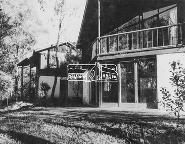
Photograph, Professor Downing - Dorian Le Gallienne House (1948-1964)
Image 8 Professor Downing - Dorian Le Gallienne House Commenced 1948. Fourth and final wing added 1964 Built by Horrie Judd, Les Puch, Wynn Roberts, Sonia Skipper and others Designed by Alistair Knox The Alistair Knox Collection The Alistair Knox Collection is a series of mounted enlarged photos of mud brick houses and related subjects. The collection is understood to have been put together by Alistair Knox although it is the work of several unacknowledged photographers. For some years it was held by the Building Department of the former Eltham Shire Council and was then passed to our Society for safekeeping. Some of the photos have been used in Knox's books and from time to time some of them have been part of various historical displays. As far as we know there has not been a public display of the whole collection which numbers about forty photographs. The collection has been copied on to slides for the purpose of this meeting and to be retained as part of the Society's pictorial collection. Alistair Knox 1912 - 1986 is acknowledged as the founder of Eltham's mud brick building movement. Many of the buildings shown in the collection are of his design and he was also involved with the construction of several of them. Others are the work of his contemporaries and associates such as Peter Glass, Gordon Ford, and John Harcourt. (EDHS Newsletter No. 145 July 2002)Handwritten notes in pencil re details of building, year of construction, owner, designer, builder, etcalistair knox design, horrie judd, houses, les puch, mud brick construction, professor downing - dorian le gallienne house, sonia skipper, wynn roberts, alistair knox collection -
 Eltham District Historical Society Inc
Photograph, Frank and Morag Jackson House (1960)
Image 25B Frank and Morag Jackson House 1960 Original building designed by Hal Peck Built by Horrie Judd and Hal Peck Extension designed by Macgregor Knox Built by Shane Aumont, commenced 1977 Completed 1978 - Interior view The Alistair Knox Collection The Alistair Knox Collection is a series of mounted enlarged photos of mud brick houses and related subjects. The collection is understood to have been put together by Alistair Knox although it is the work of several unacknowledged photographers. For some years it was held by the Building Department of the former Eltham Shire Council and was then passed to our Society for safekeeping. Some of the photos have been used in Knox's books and from time to time some of them have been part of various historical displays. As far as we know there has not been a public display of the whole collection which numbers about forty photographs. The collection has been copied on to slides for the purpose of this meeting and to be retained as part of the Society's pictorial collection. Alistair Knox 1912 - 1986 is acknowledged as the founder of Eltham's mud brick building movement. Many of the buildings shown in the collection are of his design and he was also involved with the construction of several of them. Others are the work of his contemporaries and associates such as Peter Glass, Gordon Ford, and John Harcourt. (EDHS Newsletter No. 145 July 2002)Handwritten notes in pencil re details of building, year of construction, owner, designer, builder, etcfrank and morag jackson house, frank jackson, hal peck, horrie judd, houses, macgregor knox, morag jackson, mud brick construction, alistair knox collection -
 Eltham District Historical Society Inc
Photograph, Professor Downing - Dorian Le Gallienne House (1948-1964)
Image 8 Professor Downing - Dorian Le Gallienne House Commenced 1948. Fourth and final wing added 1964 Built by Horrie Judd, Les Puch, Wynn Roberts, Sonia Skipper and others Designed by Alistair Knox The Alistair Knox Collection The Alistair Knox Collection is a series of mounted enlarged photos of mud brick houses and related subjects. The collection is understood to have been put together by Alistair Knox although it is the work of several unacknowledged photographers. For some years it was held by the Building Department of the former Eltham Shire Council and was then passed to our Society for safekeeping. Some of the photos have been used in Knox's books and from time to time some of them have been part of various historical displays. As far as we know there has not been a public display of the whole collection which numbers about forty photographs. The collection has been copied on to slides for the purpose of this meeting and to be retained as part of the Society's pictorial collection. Alistair Knox 1912 - 1986 is acknowledged as the founder of Eltham's mud brick building movement. Many of the buildings shown in the collection are of his design and he was also involved with the construction of several of them. Others are the work of his contemporaries and associates such as Peter Glass, Gordon Ford, and John Harcourt. (EDHS Newsletter No. 145 July 2002)Handwritten notes in pencil re details of building, year of construction, owner, designer, builder, etcalistair knox design, horrie judd, houses, les puch, mud brick construction, professor downing - dorian le gallienne house, sonia skipper, wynn roberts, alistair knox collection -
 Eltham District Historical Society Inc
Photograph, Frank and Morag Jackson House (1960)
Image 25A Frank and Morag Jackson House 1960 Original building designed by Hal Peck Built by Horrie Judd and Hal Peck Extension designed by Macgregor Knox Built by Shane Aumont, commenced 1977 Completed 1978 - Exterior view The Alistair Knox Collection The Alistair Knox Collection is a series of mounted enlarged photos of mud brick houses and related subjects. The collection is understood to have been put together by Alistair Knox although it is the work of several unacknowledged photographers. For some years it was held by the Building Department of the former Eltham Shire Council and was then passed to our Society for safekeeping. Some of the photos have been used in Knox's books and from time to time some of them have been part of various historical displays. As far as we know there has not been a public display of the whole collection which numbers about forty photographs. The collection has been copied on to slides for the purpose of this meeting and to be retained as part of the Society's pictorial collection. Alistair Knox 1912 - 1986 is acknowledged as the founder of Eltham's mud brick building movement. Many of the buildings shown in the collection are of his design and he was also involved with the construction of several of them. Others are the work of his contemporaries and associates such as Peter Glass, Gordon Ford, and John Harcourt. (EDHS Newsletter No. 145 July 2002)Handwritten notes in pencil re details of building, year of construction, owner, designer, builder, etcfrank and morag jackson house, frank jackson, hal peck, horrie judd, houses, macgregor knox, morag jackson, mud brick construction, alistair knox collection -
 Eltham District Historical Society Inc
Audio - Audio Recording, Jim Connor - Eltham Lower Park, 8 Feb. 2023
EDHS Newsletter No. 268 February 2023 Prior to the extension of European people into the lands of the Nillum-bik in the late 1830s the Wurundjeri people had been meeting in the area now known as Eltham Lower Park for thousands of years. Waterway junctions had a particular attraction as tribal meeting places and the junction of the Diamond Creek with the Yarra River (Birr-arung to the Wurundjeri) was one such important location in terms of aboriginal culture. The sculpture “Not Just a Pretty Place” by Aleks Danko, located near the junction of these two watercourses pays tribute to this important cultural location. The first European settlers were squatters or leaseholders and itinerants such as timber workers. Records of their early occupation are sketchy but the Eltham Lower Park area was probably included within the pastoral run established in 1841 by Henry Foley. He sold his leasehold in 1845 to Joseph Wilson who in turn sold it to Frederick Faulkner soon after. From this early history the Eltham Lower Park area has undergone many changes and has been developed to provide residents and visitors with a range of passive and active public open space, including even being used for various horse racing events. At our next meeting, Jim Connor will explore the history of Eltham Lower Park and touch on various individuals and groups involved along the way.1:05:19 duration Digital MP3 file; 22.4MBaudio recording, eltham district historical society, meeting, society meeting, jim connor, eltham, eltham lower park -
 Eltham District Historical Society Inc
Document - Folder, Ryan, Daniel, Catherine, Patrick, Jock, Jean
Daniel and Catherine came to Australia in 1856; settling at Diamond Creek; his son Patrick established the butcher shop. Patrick and Jean had three sons, one being John, rather ofJock Ryan who became an Anglican minister. Contents Newspaper article: "Home again at St John's", Diamond Valley News, 23 April 1991. Jock Ryan 's family and career in the Services and as an Anglican minister. Newspaper article: "Sedate bring centenary", Diamond Valley News, 15 April 1998. History of Diamond Creek Bridge and involvement of Ryan family. Newspaper article: "Pages a passage to past", Diamond Valley Leader 14 March 2001. Jock Ryan researching Diamond Creek history in the State Library. Newsletter article: "Honouring the Ryans", Heidelberg Historian no.217 August 2003. BroadGully Reserve renamed Ryans Reserve to acknowledge community service of the Ryan family. Newspaper article: "Penniless, brave start for clan", Diamond Valley Leader, ? January 2006. History of the Ryan family of Diamond Creek. Newspaper notice: "Ryan, Rev Jock Lugton", The Age, 15 May 2020. Death notice. Newspaper notice: "Ryan, Eleanor Jean (known as Jean) (nee Baddeley)", The Age, 12 September 2020 and 17 September 2020. Death notice.Newspaper clippings, A4 photocopies, etcjock ryan, gipson street diamond creek, patrick ryan, heidelberg council, joseph lugton, diamond creek primary school, eltham high school, melbourne high school, commonwealth rehabilitation scheme, ridley theological college, caulfield grammar school, diamond creek living and learning centre, st john's anglican church diamond creek, nillumbik historical society, pub crawl around diamond creek's historical pubs, daniel ryan, catherine ryan, diamond creek football club, jean ryan, diamond creek bridge, lanvos reserve diamond creek, broadgully road diamond creek, ryans reserve diamond creek, joan hipkin nee ryan, eleanore jean ryan nee baddeley, margaret ryan, jock lugton ryan -
City of Moorabbin Historical Society (Operating the Box Cottage Museum)
Newsletter - CMHS Moorabbin Mirror Vol 3 August 2015, Moorabbin Mirror Vol 3 August 2015, August 2015
This is Vol. 3 of the Moorabbin Mirror produced by CMHS members Fran & Holger Bader , Valma Sharp August 2015 The Moorabbin Mirror reflects the history and heritage of the former City of Moorabbin — derived from Mooroobin, ‘a resting place’ in the Bunurrung spoken language. In 1994, the City of Moorabbin was integrated into the Cities of Bayside, Glen Eira, Kingston and Monash. Members are informed of the Heritage Display at Stanley's Menswear, Bentleigh East, in conjunction with Glen Eira HS, Market Garden Display at Bendigo Bank Ormond and the Sandbelt Milestones at Brighton Cemetery, Godfrey Street Community House, St Peter's Church & School, the ongoing Gallipoli Centenary and Moorabbin Saints AFL team at Linton Street. Dates for Committee Meeting, General Meeting and the upcoming AGM in October. Photos from The Booklet and Leaflet Launch on May 13th, a request for information about the Womens’ Farm Mordialloc c 1916 , advertisements for the Bayside Arts & Cultural Exhibition featuring Tommy Bent and the RHSV Exhibition re MacPherson Robertson featuring the bust made by August Reitman at Box Cottage . Open Days are listed with an invitation for new members showing the benefits and duties of CMHS membership. CMHS thanks The Office of the Hon. Andrew Robb AO MP Minister for Trade & Investment, Federal Member for Goldstein, who photocopied this newsletter under community printing entitlements. This is Vol. 3 of the Moorabbin Mirror, Newsletter of CMHS August 2015 A4 x 3 paper folded to A5 x 6pp with colour photographs. Moorabbin / Mirror / August 2015 Issue 3 moorabbin mirror, bader fran, bader holger, sharp valma, bent tommy, mordialloc womens farm c1916, gallipoli landings 1915, robertson macpherson, reitman august, godrfrey street community hhouse bentleigh, st peter's church bentleigh east, brighton cemetery, bendigo bank ormond, stanley's menwear bentleigh, glen eira historical society, launch of box cottage museum publications 2015, glen eira city council,east -
City of Moorabbin Historical Society (Operating the Box Cottage Museum)
Newsletter - City of Moorabbin Historical Society Nov. 2015, November 2015
This is Vol. 4 of the Moorabbin Mirror produced by CMHS members Fran & Holger Bader , Valma Sharp November 2015 The Moorabbin Mirror reflects the history and heritage of the former City of Moorabbin - derived from Mooroobin, ' a resting place' in the Bunurrung spoken language. In 1994 the City of Moorabbin was integrated into the Cities of Bayside, Glen Eira, Kingston and Monash. Members are asked to assist GECC Arts & Culture Dept. with information about the Caulfield Repatriation Hospital. Fran compiled a brief history of the 'Garden Suburb of Ormond, Henry Lawson and ANA Society with a contribution from Rosemary Kelleher describing her father Brian's love of poetry. All members are invited to attend the final Open day on November 29th to join with the Henry Lawson Society and ANA for their Annual Brian Kelleher Memorial Picnic . Photographs of the CMHS at Bunnings, Stanley's Menswear and the 'Unmentionables' display at Box Cottage are included in this issue. The CMHS thanks the retiring President Frank Thatcher and Treasurer Bill Richardson for their work for the Society and welcomes the incoming Committee lead by Mrs Valma Sharp President. Mrs Lorna Thatcher was recognised for her long service to CMHS with Life Membership accepted by members. Open Days are listed with an invitation for new members showing the benefits and duties of CMHS membership. CMHS thanks The Office of the Hon. Andrew Robb AO MP Minister for Trade & Investment, Federal Member for Goldstein, who photocopied this newsletter under community printing entitlements.A4 x 3 paper folded to A5 x 4 pages with colour photographsMoorabbin / Mirror / November 2015 Issue 4moorabbin mirror, bader fran, bader holger, sharp valma,gallipoli landings 1915, robertson macpherson, reitman august, brighton cemetery, bendigo bank ormond, stanley's menwear bentleigh, glen eira historical society, glen eira city council,, thatcher lorna, thatcher frank, richardson bill, henry lawson society, ana society, kelleher brian, sharp valma, monash, kingston, bayside,