Showing 32718 items matching "shire or eltham"
-
 Eltham District Historical Society Inc
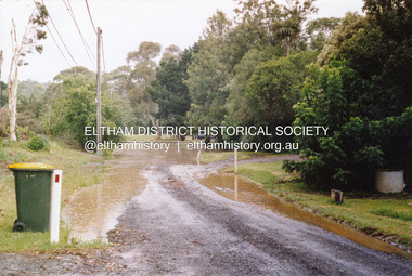
Photograph, Flooding of Diamond Creek, Eltham, Feb 2005, 2005
Two colour photographs of the Diamond Creek floodwater; two at Souter Street and one looking north across the Eltham Rugby Union Football Club oval towards the Bridge Street bridge, Feb 2005eltham, diamond creek, floods, souter street, bridge street -
 Warrnambool and District Historical Society Inc.
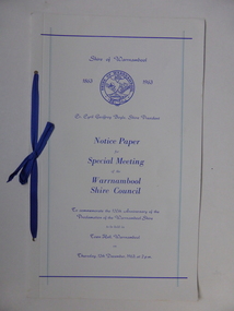
Document, Collett and Bain, Notice of meeting Warrnambool Shire, 1963
This booklet commemorates the 100th anniversary of the proclamation of the Shire of Warrnambool. The original proclamation was read from the Government gazette 13/12/1863 Pg 2958. This follows from being proclaimed a roads district in 1854 which was then partly portioned and proclaimed the Municipal district in 1855. Portion of the shire was again annexed to the city in 1955. The Warrnambool shire covers the area on north east and western sides of the city of Warrnambool covering approximately 600 square miles and has a rich history of farming and dairy products. A program which commemorates 100 years of the shire of Warrnambool. It contains a comprehensive list of councillors who served during that time.White light card cover with royal blue text and tied with royal blue ribbon.Pale blue vertical lines. Shire crest with dates either side at top centre of page.Back cover has list of councillors names who have served from 1863 up to 1963. Photographs in green tinge inside front and back covers. 8 pages. Cr Cyril Geoffery Boyle. Thursday 12th December 1963.Mr Robert Burke, Cr C S Brown, Cr C G Boyle, A F Ponting,The Honourable Murray Porter, Hon R W Mack, Cr J Pascoe, Mr J W Crawley, Mr L Crawley, J Wm Crawley, Jnr, R L Crawleywarrnambool,, warrnambool shire, cr c g boyle, warrnambool shire 1863, warrnambool shire 1963 -
 Eltham District Historical Society Inc
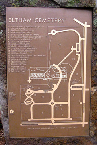
Photograph, Jim Connor, Eltham Cemetery, Mount Pleasant Road, Eltham, 2 Sep 2009
Guide map, Eltham CemeteryTomorrow's history documented todayeltham, jim connor collection, eltham cemetery -
 Eltham District Historical Society Inc
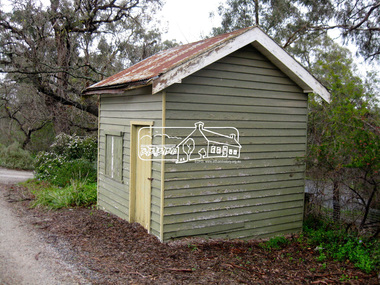
Photograph, Jim Connor, Eltham Cemetery, Mount Pleasant Road, Eltham, 2 Sep 2009
Worker's shed, Eltham CemeteryTomorrow's history documented todayeltham, jim connor collection, eltham cemetery -
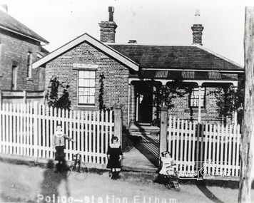 Eltham District Historical Society Inc
Photograph, Police House, Main Road Eltham, 1890s
Police Sergeant's family house, Police Station to right and Courthouse to left of house..Copy of black and white photograph of brick Police residence, 728 Main Road, Eltham, cnr. Brougham Street. Photograph includes 3 young children in front of fence. Circa 1890s police residence, police station, courthouse, eltham, main road, houses -
 Eltham District Historical Society Inc
Photograph, Harry Gilham, Shoestring, Metery Road, Eltham, March 2004, 2004
Built in the 1860s by David Clark, Head Teacher of Eltham State School No. 209. David Clark was the foundation Head Teacher of Eltham primary School which was opened in 1856 and situated on the current site since 1857.Colour printdavid clark, eltham primary school, eltham state school, houses, metery road, shoestring, streets -
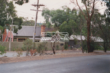
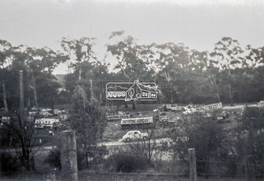
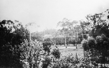
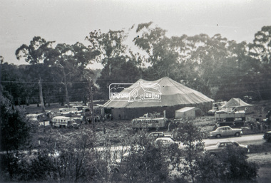 Eltham District Historical Society Inc
Slide - Photograph, Grace Mitchell, Ashtons Circus set up in Bremner's Reserve, Main Road, Eltham, c.1955
View from Grace Mitchell's shop at the corner of Mount Pleasant Road and Main Road. Grace Mitchell was probably best known for her Eltham shop at the corner of Mt Pleasant Road and Main Road. Grace's memories covered many local identities who were patrons of her shop between 1954 and 1971. From the elevated position of her shop and home Grace was able to view a varied passing parade of Eltham events from ERSILAC, Easter and Eltham Festival parades passing on their way to Eltham Lower Park, circuses in Wingrove Park (then Bremner’s Reserve), roadworks and other happenings. Bremner's Reserve was renamed Wingrove Park c.1970 This photo was from a series of images presented by Grace Mitchell at a Society talk 10 March 1993 on the theme of “My Eltham”.35mm Kodak 5052 TMX Black and White transparency, 1 strip, 6 frames Black and white print 17 x 25.4 cmashtons circus, bremner's flat, circus, grace mitchell, main road, mount pleasant road, wingrove park -
 Eltham District Historical Society Inc
Photograph, Grace Mitchell, Bremners Flat, Main Road, Eltham, 1958c
View from Grace Mitchell's shop at the corner of Mount Pleasant Road and Main Road. Grace Mitchell was probably best known for her Eltham shop at the corner of Mt Pleasant Road and Main Road. Grace's memories covered many local identities who were patrons of her shop between 1954 and 1971. From the elevated position of her shop and home Grace was able to view a varied passing parade of Eltham events from ERSILAC, Easter and Eltham Festival parades passing on their way to Eltham Lower Park, circuses in Wingrove Park (then Bremner’s Reserve), roadworks and other happenings. Bremner's Reserve was renamed Wingrove Park c.1970 This photo was from a series of images presented by Grace Mitchell at a Society talk 10 March 1993 on the theme of “My Eltham”.Black and white print 17 x 25.4 cmbremner's flat, main road, mount pleasant road, wingrove park -
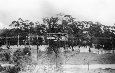 Eltham District Historical Society Inc
Photograph, Grace Mitchell, Diamond Creek in flood, Bremners Flat, Main Road, Eltham, c.1958
View from Grace Mitchell's shop at the corner of Mount Pleasant Road and Main Road. Grace Mitchell was probably best known for her Eltham shop at the corner of Mt Pleasant Road and Main Road. Grace's memories covered many local identities who were patrons of her shop between 1954 and 1971. From the elevated position of her shop and home Grace was able to view a varied passing parade of Eltham events from ERSILAC, Easter and Eltham Festival parades passing on their way to Eltham Lower Park, circuses in Wingrove Park (then Bremner’s Reserve), roadworks and other happenings. Bremner's Reserve was renamed Wingrove Park c.1970 This photo was from a series of images presented by Grace Mitchell at a Society talk 10 March 1993 on the theme of “My Eltham”.Black and white print 17 x 25.4 cmbremner's flat, diamond creek, floods, main road, mount pleasant road, wingrove park -
 Eltham District Historical Society Inc
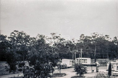
Slide - Photograph, Grace Mitchell, Portable buildings on trucks possibly for installation at the Golden Fleece Service Station, corner of Main Road and Mount Pleasant Road, Eltham, c.1961
View from Grace Mitchell's shop at the corner of Mount Pleasant Road and Main Road. Grace Mitchell was probably best known for her Eltham shop at the corner of Mt Pleasant Road and Main Road. Grace's memories covered many local identities who were patrons of her shop between 1954 and 1971. From the elevated position of her shop and home Grace was able to view a varied passing parade of Eltham events from ERSILAC, Easter and Eltham Festival parades passing on their way to Eltham Lower Park, circuses in Wingrove Park (then Bremner’s Reserve), roadworks and other happenings. Bremner's Reserve was renamed Wingrove Park c.1970 This photo was from a series of images presented by Grace Mitchell at a Society talk 10 March 1993 on the theme of “My Eltham”.35mm Kodak 5052 TMX Black and White transparency, 1 strip, 6 frames Black and white print 17 x 25.4 cmgolden fleece service station, main road, mount pleasant road -
 Lakes Entrance Historical Society
Book, Bairnsdale Shire Council Centenary 1868, 1968
A short history of the Shire of Bairnsdale Victoria from beginnings as a road district to the separation of the commercial centre as the Towns of Bairnsdale illustrated with photographs. A list of Shire Presidents and officers is included.township, photography -
Eltham District Historical Society Inc
Folder, George Eltham
Folder of information on George Eltham, Helmsman, 'Young Australian'george eltham, marilynne eltham -
Tatura Irrigation & Wartime Camps Museum
registration disc, Pre 1993
Shire issued various registration tags for animals.Brass plate issued by the Shire of Rodney as registration for an animal. Designed to be attached to a collar. Pointed at both ends to be pushed into collar.Rodney Shire No.10 -
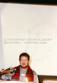
 Eltham District Historical Society Inc
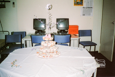
Photograph, 40th Anniversary Lunch, Eltham District Historical Society, Eltham Courthouse, 14 July 2007, 14/07/2007
3 colour photographseltham, activities, courthouse, 40th anniversary, main road, eltham district historical society, jim connor, robyn wood -
 Eltham District Historical Society Inc
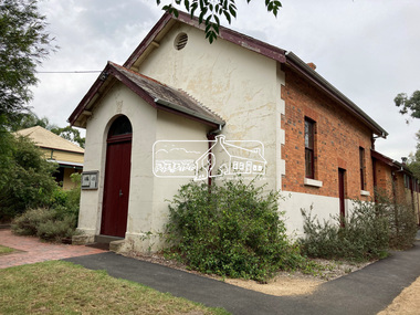
Photograph, Jim Connor, Avenue of Honour, Main Road, Eltham, 3 Apr 2021
Former Eltham Courthouse, 730 Main Road immediately prior to major restoration works undertaken by Nillumbik Shire Council. The Courthouse is the oldest public building in the shire. It was built in 1860 and ceased operations as part of the Court of Petty Sessions in 1985.Tomorrow's history documented todayeltham, jim connor collection, main road, eltham gateway, eltham courthouse, eltham justice precinct, avenue of honour -
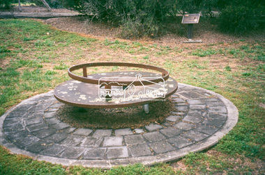 Eltham District Historical Society Inc
Slide - Photograph, Monument with time capsule, Eltham Community Centre, Main Road, Eltham, c.1997
The monument with time capsule was established by the Shire of Eltham Historical Society to commemorate Victoria’s 150th anniversary and mark the former location of the Eltham Town Centre, which existed along this section of Main Road, then known as Maria Street. The unveiling was conducted 10 November 1985 by Cr. Mary Grant (Shire President). The monument was constructed with a concrete base and the main feature is an old tyring plate or disc. The Time Capsule Ceremony involved lowering the sealed time capsule into place, bolting down its container lid and then concreting over the lid. The capsule contains items relating to present day (1985) Eltham and its people including a video film made by Joh Ebeli and also details of families and organizations who have contributed to construction of the monument. It is to be opened in the year 2035. The Society received an excellent response from local people, firms and organizations by way of assistance with this project. Graham Beyer, who originated the project, arranged many of the donations. He and his firm, Package Handling Equipment, donated the time capsule itself and carried out fabrication of sections of the monument. The design of the monument was adapted by Graham Beyer from drawings by Joh Ebeli. Charmac Industries donated the container for the time capsule and a cast gun metal name plate for the monument. BMG Concrete donated concrete for the base which was constructed by Caridi Construction Company. Northbourne Garden Supplies donated materials for the paving around the monument. Robert Becker from Eltham Apex directed construction of the paving by Society members. Terry Hutchinson donated the use of his crane to lift the tyring disc into place. Financial contributions were also made by the Eltham Chamber of Commerce and the Rotary Club of Eltham. In 1987 in commemoration of the Society’s 20th Anniversary, Joh Ebeli suggested the commissioning of a plaque to be added which explains the functions of the various items used in the Society’s Victorian 150th Anniversary Monument and this was unveiled by its designer, Joh Ebeli, on October 10, 1987.35mm colour positive transparency Mount - Black and Whiteeltham, eltham community centre, monument, public art, time capsule -
 Eltham District Historical Society Inc
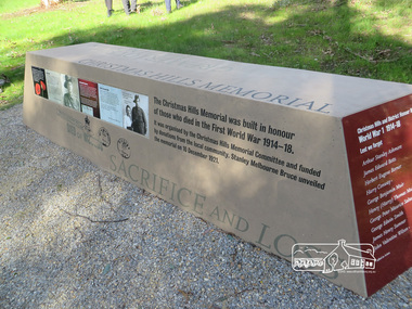
Photograph, Shire of Nillumbik World War One Memorials tour, 10 August 2016, 10 August 2016
As part of a program to acknowledge the Anzac Centenary Nillumbik Shire Council partnered with Yarra Plenty Regional Library to provide a bus tour with commentary of local sites of significance. These included Eltham township, the Shire of Eltham War Memorial at Kangaroo Ground, Christmas Hills war memorial, Hurstbridge memorial recreation park and finshed at Eltham Library to view the Writing the War exhibtion at Eltham Library Community Gallery. In May 2015 Nillumbik Shire Council received Anzac Centenary Local Grants Program funding for the restoration and enhancement of the Christmas Hills cenotaph as a project to commemorate the First World War An interpretative project lists names on the honour roll for Christmas Hills and District with stories and photographsBorn Digitalworld war 1, war memorials, shire of nillumbik, christmas hills, interpretative signage -
 Eltham District Historical Society Inc
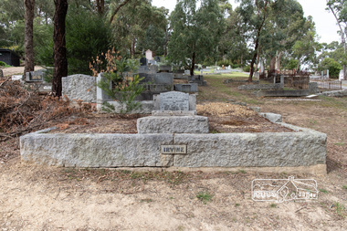
Photograph, Peter Pidgeon, Grave of William Hill and Agnes Somerville Irvine and family, Eltham Cemetery, Victoria, 5 April 2021
William Hill Irvine was born 6 July, 1858 in Newry, County Down, Ireland. He arrived in Melbourne December 1879 and taught at Geelong College. He was admitted to the Supreme Court in 1884 having qualified from Melbourne University and practiced in Melbourne. In 1891 he married Agnes Somerville Wanliss and they had one son, William Mitchell (1901 Armadale) and two daughters, Beatrice Wanliss (1899 Armadale) and Agnes Somerville Wanliss (1903 Armadale). Sir William Irvine sat in the Victorian Parliament (as Liberal Member for Lowan) from 1894 to 1906 and was Premier of Victoria from 1902 to 1904. He then switched to Federal politics and sat in the Commonwealth Parliament (as Liberal Member for Flinders) from 1906 to 1918. He was considered a potential Prime Minister, but his abrupt manner and hard-line conservatism (particularly his attitude to a railway strike) made him unacceptable even to many Liberals: he was known in Parliament as "Iceberg Irvine". He lived at Richmond, but in 1908 purchased land in Laughing Waters Road at Eltham, where he built the house ‘Killeavey’, initially as a weekend retreat. The site, a peninsula surrounded on three sides by the Yarra River, is of geological importance and has considerable cultural significance to the Wurundjeri. In 1912 Sir William moved to Killeavey and in 1913 purchased more land, extending his property to Reynolds Road. In 1923 he shifted to Toorak, donating Killeavey to his daughter Beatrice as a wedding gift. Sir William was a founding member of the RACV and was Acting Governor of Victoria from 1931 to 1934. He was also a notable public figure involved in several local events including the: 1919 Unveiling of Eltham War Obelisk 1921 Eltham Primary School Extensions 1921 Eltham Primary School Roll of Honour of prior students 1928 Opening of Eltham Higher Elementary School 1926 Unveiling the Shire of Eltham War Memorial in Memorial Park at Kangaroo Ground He died in 1943 and is buried in Eltham Cemetery with his wife Agnes along with son William Mitchell Irvine and his wife, Dora Haswell Sacred to the memory of William Hill Irvine G.C.M.G. Lieutenant Governor And Chief Justice of Victoria Born 6th July 1858 At Newry, Northern Ireland Died 20th August 1943 Also his wife Agnes Somerville Born at Ballarat 16th Nov 1867 Died at Eltham 16th Aug 1954 W. M. W. Irvine 1901-1975 And Dora Haswell Wife of W. M. W. Irvine 1900-1979Born Digitaleltham cemetery, gravestones, agnes sommerville irvine (nee wanliss), dora haswell irvine, william hill irvine, william mitchell irvine -
 Eltham District Historical Society Inc
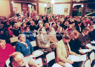
Photograph, Meeting to discuss the new Nillumbik Shire, 1994
Nillumbik Shire Council - Shire of Eltham Archives Series 046 Series consists of colour photographs, 215mm x 150mm, depicting citizens and speakers at the meeting, including CEO Rodney Roscholler.Colour photograph1994, council amalgamation, nillumbik shire, public meeting, shire of eltham, series 46, shire of eltham archives -
 Eltham District Historical Society Inc
Photograph, Meeting to discuss the new Nillumbik Shire, November 1994
Nillumbik Shire Council - Shire of Eltham Archives Series 046 Series consists of colour photographs, 215mm x 150mm, depicting citizens and speakers at the meeting, including CEO Rodney Roscholler.Colour photograph1994, council amalgamation, nillumbik shire, public meeting, shire of eltham, series 46, shire of eltham archives -
 Eltham District Historical Society Inc
Photograph, Liz Pidgeon, Heritage Excursion; The 1901 Eltham Railway Walk, 3 May 2014, 3 May 2014
Newsletter No. 216, May 2014 May Excursion – The 1901 Eltham Railway Walk The railway from Heidelberg to Eltham was opened in 1902. Over the previous year railway construction cut a curving swathe through Josiah Holloway’s 1851 Little Eltham subdivision. The survey plans for the railway show the owners and occupiers of land within Little Eltham affected by the railway alignment and for some distance each side. The plans show houses and other buildings but development at that time was rather sparse. Copies of these plans from the State Library of Victoria collection have been provided to the Society by Alan Sheehan. For our walk on 3rd May we intend to follow the railway from the Eltham Station to Ryans Road, which was the boundary of the adjoining Montmorency Farm. The return will be by way of nearby streets. Along the way we will discuss the details shown on the railway plans as well as more recent railway documents and photographs. At the conclusion and if time permits we can inspect the historical display at the Eltham Station. The walk is about 3 km in length and will take about 2.5 hours. It will start at 2 pm at the Eltham Railway Station car park (east/Main Road side) (Melway Ref. 21 J5).Born Digitalheritage excursion, activities, eltham district historical society, eltham railway station, eltham library, trestle bridge -
 Eltham District Historical Society Inc
Photograph, Liz Pidgeon, Heritage Excursion; The 1901 Eltham Railway Walk, 3 May 2014, 3 May 2014
Newsletter No. 216, May 2014 May Excursion – The 1901 Eltham Railway Walk The railway from Heidelberg to Eltham was opened in 1902. Over the previous year railway construction cut a curving swathe through Josiah Holloway’s 1851 Little Eltham subdivision. The survey plans for the railway show the owners and occupiers of land within Little Eltham affected by the railway alignment and for some distance each side. The plans show houses and other buildings but development at that time was rather sparse. Copies of these plans from the State Library of Victoria collection have been provided to the Society by Alan Sheehan. For our walk on 3rd May we intend to follow the railway from the Eltham Station to Ryans Road, which was the boundary of the adjoining Montmorency Farm. The return will be by way of nearby streets. Along the way we will discuss the details shown on the railway plans as well as more recent railway documents and photographs. At the conclusion and if time permits we can inspect the historical display at the Eltham Station. The walk is about 3 km in length and will take about 2.5 hours. It will start at 2 pm at the Eltham Railway Station car park (east/Main Road side) (Melway Ref. 21 J5).Born Digitalheritage excursion, activities, eltham district historical society, eltham railway station, eltham library, trestle bridge