Showing 2835 items
matching fences
-
 Eltham District Historical Society Inc
Photograph (item), J.H. Clark, View of Eltham from Main Road, c.1907
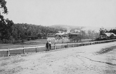
An F-class 2-4-0 steam locomotive and tender hauls a train of two open wagons, a guards van and a single Tait passenger car over the Eltham Railway Trestle Bridge, heading for Melbourne. This type of steam locomotive was replaced by the F-Class 2-4-2. The house on the right, originally known as 'Derril' was purchased in the early 1920s by Walter Ernest and Alice Miriam Gahan. On the western side of Main Road near the present-day site of Shillinglaw Cottage, they remained till about 1960 when Walter died. The house was demolished in 1968 during the widening of Main Road. In the distance beyond the trestle bridge on what would become Central Park appears to be an orchard of fruit trees. A young man with waist coat, jacket and hat stands beside an older man wearing suspenders without jacket and bare headed, sitting on the post fence. Photographer: J.H. Clark John Henry Clark was the youngest of three boys born to William Henry Clark (1823-1877) and Maria White (1843-1914). He and his brothers, William Charles Clark (1872-1945), Clement Kent Clark (1874-1912) operated a photography business (Clark Bros.) from 25 Thomas Street, Windsor near Prahran during the period c.1894 to 1914. Following death of Clement in September 1912 and their mother in 1914, the Clark Bros business appears to have dissolved, the premises demolished, and a new house was under construction in 1915. John set up business independently in 1914 operating out of 29 Moor Street, Fitzroy where he is registered in the 1914 and 1915 Electoral Rolls. By 1916 John had relocated to Eltham where he continued his practice as a photographer and took many of the early images around the district of Little Eltham. Around 1930 John changed professions and opened a small cobbler's shop in 1931 near the pond opposite Dalton Street adjacent to the Jarrold family cottage. He never married and continued his profession as a bootmaker from this little shop, maintaining a close relationship with Mrs Jarrold for the rest of their lives. His bootmaker shop remains today beside the Whitecloud cottage and is one of only three remaining shops in the area from the early 20th century. There are a couple of images of Eltham taken by Clark Bros. in the Eltham District Historical Society collection, one such example being Hunniford’s Post Office with Miss Anne Hunniford out front (EDHS_00140 - marked on the back of the print, Clark Bros., 25 Thomas St. Windsor), which would date this image between c.1894 and 1914. Other early images of Eltham taken by John Henry Clark are marked on the face “J. H. Clark Photo” and it is assumed these are dated between 1914 and 1930. It is noted that the Grant of Probate for John H Clark of Eltham South dated 5 April !957 (513/387) records his occupation as "X Photographer".derril, eltham railway trestle bridge, f-class 2-4-0 steam locomotive, gahan house, j.h. clark photo, main road, orchards, postcards, steam train, tait train, victorian railways -
 Eltham District Historical Society Inc
Photograph, Murchison Gap, Autumn Excursion, Hume and Hovell's 1824 expedition, 26 May 1996, 26/05/1996
[article by Bettina Woodburn in EDHS Newsletter No. 109, July 1996:] ON THE TRAIL OF HUME AND HOVELL - REPORT ON THE AUTUMN EXCURSION - On a green and fresh morning (Sunday 26th May 1996) the Cobb and Co coach (driven by the most obliging Peter Tampion) set off in a north easterly direction from Eltham to connect with Hume and Hovell's route on their 1824 explorations of central Victoria. The Society would follow a series of monuments erected for the 1924 centenary of the expedition from King Parrot Creek (Tuesday 7th December 1824), through Strath Creek, over Sunday Creek (Sunday 12th December 1824) at Broadford, Tullamarine, St Albans, Deer Park, through Werribee, skirting east of the You Yangs to Lara and Avalon Beach. Because their distance-measuring wheel had broken and a one degree mistake was made in calculations, the two leaders of the original group of six convict-companions arrived at Corio Bay, instead of the expected Western Port, discovered earlier by Flinders. From below Mt. Disappointment (Hume and Hovell's difficulties in "scrambling over brush and rock", "leeches in forest, as well as no water", "cutting grass 4-5 ft. high", dreadful scrub", "devil flies") we took an easier route, saw the Strath Creek memorial in ground fog and a wonderful "field of dreams", the Hume-Hovell privately owned cricket ground with its white picket boundary fence. Now, after a steep climb, in sunshine under gums we stretched and viewed magnificent rolling hills and fog-filled valleys - not "smoke from Aborigines' bush fires". After morning tea at Broadford we followed the Sunday Creek valley beside the Hume Freeway, passed the Wallan Wallan Rest Area (more appropriately Hume and Hovell Rest Area) to tum right at Beveridge. In Gellibrand Hill Park, near the headwaters of the Moonee Ponds Creek, we experienced the landscape the first European settlers saw - huge river red gums and rolling pastures. The gardens and sheltered courtyard of the 1840s, timber, brought from .....[?] prefabricated Woodlands Homestead, provided a pleasant lunch stop. We enjoyed a private tour, panoramic views over Melbourne and surroundings and the excitement of arriving and departing aircraft. Our next river crossing was at Werribee, "in a vast treeless plain", then we drove on by-ways no coach had previously travelled, to find "an immense sheet of water" salty Corio Bay, off-course to the west. In late afternoon of a super, calm, late autumn day we headed homewards. Back at Eltham we were rather surprised to find that we had travelled a total of 347 km. Thanks again to Russell Yeoman for his research and organization. What a wonderful day! Three colour photographsactivities, murchison gap, murchison valley -
 Eltham District Historical Society Inc
Photograph, Hume and Hovell Monument, Broadford, Autumn Excursion, Hume and Hovell's 1824 expedition, 26 May 1996, 26/05/1996
[article by Bettina Woodburn in EDHS Newsletter No. 109, July 1996:] ON THE TRAIL OF HUME AND HOVELL - REPORT ON THE AUTUMN EXCURSION - On a green and fresh morning (Sunday 26th May 1996) the Cobb and Co coach (driven by the most obliging Peter Tampion) set off in a north easterly direction from Eltham to connect with Hume and Hovell's route on their 1824 explorations of central Victoria. The Society would follow a series of monuments erected for the 1924 centenary of the expedition from King Parrot Creek (Tuesday 7th December 1824), through Strath Creek, over Sunday Creek (Sunday 12th December 1824) at Broadford, Tullamarine, St Albans, Deer Park, through Werribee, skirting east of the You Yangs to Lara and Avalon Beach. Because their distance-measuring wheel had broken and a one degree mistake was made in calculations, the two leaders of the original group of six convict-companions arrived at Corio Bay, instead of the expected Western Port, discovered earlier by Flinders. From below Mt. Disappointment (Hume and Hovell's difficulties in "scrambling over brush and rock", "leeches in forest, as well as no water", "cutting grass 4-5 ft. high", dreadful scrub", "devil flies") we took an easier route, saw the Strath Creek memorial in ground fog and a wonderful "field of dreams", the Hume-Hovell privately owned cricket ground with its white picket boundary fence. Now, after a steep climb, in sunshine under gums we stretched and viewed magnificent rolling hills and fog-filled valleys - not "smoke from Aborigines' bush fires". After morning tea at Broadford we followed the Sunday Creek valley beside the Hume Freeway, passed the Wallan Wallan Rest Area (more appropriately Hume and Hovell Rest Area) to tum right at Beveridge. In Gellibrand Hill Park, near the headwaters of the Moonee Ponds Creek, we experienced the landscape the first European settlers saw - huge river red gums and rolling pastures. The gardens and sheltered courtyard of the 1840s, timber, brought from .....[?] prefabricated Woodlands Homestead, provided a pleasant lunch stop. We enjoyed a private tour, panoramic views over Melbourne and surroundings and the excitement of arriving and departing aircraft. Our next river crossing was at Werribee, "in a vast treeless plain", then we drove on by-ways no coach had previously travelled, to find "an immense sheet of water" salty Corio Bay, off-course to the west. In late afternoon of a super, calm, late autumn day we headed homewards. Back at Eltham we were rather surprised to find that we had travelled a total of 347 km. Thanks again to Russell Yeoman for his research and organization. What a wonderful day! Colour photographactivities, broadford, hume and hovell, monument -
 Eltham District Historical Society Inc
Photograph, Hume and Hovell Monument, Autumn Excursion, Hume and Hovell's 1824 expedition, 26 May 1996, 26/05/1996
[article by Bettina Woodburn in EDHS Newsletter No. 109, July 1996:] ON THE TRAIL OF HUME AND HOVELL - REPORT ON THE AUTUMN EXCURSION - On a green and fresh morning (Sunday 26th May 1996) the Cobb and Co coach (driven by the most obliging Peter Tampion) set off in a north easterly direction from Eltham to connect with Hume and Hovell's route on their 1824 explorations of central Victoria. The Society would follow a series of monuments erected for the 1924 centenary of the expedition from King Parrot Creek (Tuesday 7th December 1824), through Strath Creek, over Sunday Creek (Sunday 12th December 1824) at Broadford, Tullamarine, St Albans, Deer Park, through Werribee, skirting east of the You Yangs to Lara and Avalon Beach. Because their distance-measuring wheel had broken and a one degree mistake was made in calculations, the two leaders of the original group of six convict-companions arrived at Corio Bay, instead of the expected Western Port, discovered earlier by Flinders. From below Mt. Disappointment (Hume and Hovell's difficulties in "scrambling over brush and rock", "leeches in forest, as well as no water", "cutting grass 4-5 ft. high", dreadful scrub", "devil flies") we took an easier route, saw the Strath Creek memorial in ground fog and a wonderful "field of dreams", the Hume-Hovell privately owned cricket ground with its white picket boundary fence. Now, after a steep climb, in sunshine under gums we stretched and viewed magnificent rolling hills and fog-filled valleys - not "smoke from Aborigines' bush fires". After morning tea at Broadford we followed the Sunday Creek valley beside the Hume Freeway, passed the Wallan Wallan Rest Area (more appropriately Hume and Hovell Rest Area) to tum right at Beveridge. In Gellibrand Hill Park, near the headwaters of the Moonee Ponds Creek, we experienced the landscape the first European settlers saw - huge river red gums and rolling pastures. The gardens and sheltered courtyard of the 1840s, timber, brought from .....[?] prefabricated Woodlands Homestead, provided a pleasant lunch stop. We enjoyed a private tour, panoramic views over Melbourne and surroundings and the excitement of arriving and departing aircraft. Our next river crossing was at Werribee, "in a vast treeless plain", then we drove on by-ways no coach had previously travelled, to find "an immense sheet of water" salty Corio Bay, off-course to the west. In late afternoon of a super, calm, late autumn day we headed homewards. Back at Eltham we were rather surprised to find that we had travelled a total of 347 km. Thanks again to Russell Yeoman for his research and organization. What a wonderful day! Two colour photographsactivities, hume and hovell, monument -
 Eltham District Historical Society Inc
Photograph, Hume and Hovell Monument, Broadford, Autumn Excursion, Hume and Hovell's 1824 expedition, 26 May 1996, 26/05/1996
[article by Bettina Woodburn in EDHS Newsletter No. 109, July 1996:] ON THE TRAIL OF HUME AND HOVELL - REPORT ON THE AUTUMN EXCURSION - On a green and fresh morning (Sunday 26th May 1996) the Cobb and Co coach (driven by the most obliging Peter Tampion) set off in a north easterly direction from Eltham to connect with Hume and Hovell's route on their 1824 explorations of central Victoria. The Society would follow a series of monuments erected for the 1924 centenary of the expedition from King Parrot Creek (Tuesday 7th December 1824), through Strath Creek, over Sunday Creek (Sunday 12th December 1824) at Broadford, Tullamarine, St Albans, Deer Park, through Werribee, skirting east of the You Yangs to Lara and Avalon Beach. Because their distance-measuring wheel had broken and a one degree mistake was made in calculations, the two leaders of the original group of six convict-companions arrived at Corio Bay, instead of the expected Western Port, discovered earlier by Flinders. From below Mt. Disappointment (Hume and Hovell's difficulties in "scrambling over brush and rock", "leeches in forest, as well as no water", "cutting grass 4-5 ft. high", dreadful scrub", "devil flies") we took an easier route, saw the Strath Creek memorial in ground fog and a wonderful "field of dreams", the Hume-Hovell privately owned cricket ground with its white picket boundary fence. Now, after a steep climb, in sunshine under gums we stretched and viewed magnificent rolling hills and fog-filled valleys - not "smoke from Aborigines' bush fires". After morning tea at Broadford we followed the Sunday Creek valley beside the Hume Freeway, passed the Wallan Wallan Rest Area (more appropriately Hume and Hovell Rest Area) to tum right at Beveridge. In Gellibrand Hill Park, near the headwaters of the Moonee Ponds Creek, we experienced the landscape the first European settlers saw - huge river red gums and rolling pastures. The gardens and sheltered courtyard of the 1840s, timber, brought from .....[?] prefabricated Woodlands Homestead, provided a pleasant lunch stop. We enjoyed a private tour, panoramic views over Melbourne and surroundings and the excitement of arriving and departing aircraft. Our next river crossing was at Werribee, "in a vast treeless plain", then we drove on by-ways no coach had previously travelled, to find "an immense sheet of water" salty Corio Bay, off-course to the west. In late afternoon of a super, calm, late autumn day we headed homewards. Back at Eltham we were rather surprised to find that we had travelled a total of 347 km. Thanks again to Russell Yeoman for his research and organization. What a wonderful day! Colour photographactivities, broadford, hume and hovell, monument -
 Eltham District Historical Society Inc
Photograph, Strath Creek, Autumn Excursion, Hume and Hovell's 1824 expedition, 26 May 1996, 26/05/1996
[article by Bettina Woodburn in EDHS Newsletter No. 109, July 1996:] ON THE TRAIL OF HUME AND HOVELL - REPORT ON THE AUTUMN EXCURSION - On a green and fresh morning (Sunday 26th May 1996) the Cobb and Co coach (driven by the most obliging Peter Tampion) set off in a north easterly direction from Eltham to connect with Hume and Hovell's route on their 1824 explorations of central Victoria. The Society would follow a series of monuments erected for the 1924 centenary of the expedition from King Parrot Creek (Tuesday 7th December 1824), through Strath Creek, over Sunday Creek (Sunday 12th December 1824) at Broadford, Tullamarine, St Albans, Deer Park, through Werribee, skirting east of the You Yangs to Lara and Avalon Beach. Because their distance-measuring wheel had broken and a one degree mistake was made in calculations, the two leaders of the original group of six convict-companions arrived at Corio Bay, instead of the expected Western Port, discovered earlier by Flinders. From below Mt. Disappointment (Hume and Hovell's difficulties in "scrambling over brush and rock", "leeches in forest, as well as no water", "cutting grass 4-5 ft. high", dreadful scrub", "devil flies") we took an easier route, saw the Strath Creek memorial in ground fog and a wonderful "field of dreams", the Hume-Hovell privately owned cricket ground with its white picket boundary fence. Now, after a steep climb, in sunshine under gums we stretched and viewed magnificent rolling hills and fog-filled valleys - not "smoke from Aborigines' bush fires". After morning tea at Broadford we followed the Sunday Creek valley beside the Hume Freeway, passed the Wallan Wallan Rest Area (more appropriately Hume and Hovell Rest Area) to tum right at Beveridge. In Gellibrand Hill Park, near the headwaters of the Moonee Ponds Creek, we experienced the landscape the first European settlers saw - huge river red gums and rolling pastures. The gardens and sheltered courtyard of the 1840s, timber, brought from .....[?] prefabricated Woodlands Homestead, provided a pleasant lunch stop. We enjoyed a private tour, panoramic views over Melbourne and surroundings and the excitement of arriving and departing aircraft. Our next river crossing was at Werribee, "in a vast treeless plain", then we drove on by-ways no coach had previously travelled, to find "an immense sheet of water" salty Corio Bay, off-course to the west. In late afternoon of a super, calm, late autumn day we headed homewards. Back at Eltham we were rather surprised to find that we had travelled a total of 347 km. Thanks again to Russell Yeoman for his research and organization. What a wonderful day! Colour photographactivities, monument, hume and hovell, murchison valley, strath creek -
 Eltham District Historical Society Inc
Photograph, Murchison Gap viewed from Strath Creek, Autumn Excursion, Hume and Hovell's 1824 expedition, 26 May 1996, 26/05/1996
[article by Bettina Woodburn in EDHS Newsletter No. 109, July 1996:] ON THE TRAIL OF HUME AND HOVELL - REPORT ON THE AUTUMN EXCURSION - On a green and fresh morning (Sunday 26th May 1996) the Cobb and Co coach (driven by the most obliging Peter Tampion) set off in a north easterly direction from Eltham to connect with Hume and Hovell's route on their 1824 explorations of central Victoria. The Society would follow a series of monuments erected for the 1924 centenary of the expedition from King Parrot Creek (Tuesday 7th December 1824), through Strath Creek, over Sunday Creek (Sunday 12th December 1824) at Broadford, Tullamarine, St Albans, Deer Park, through Werribee, skirting east of the You Yangs to Lara and Avalon Beach. Because their distance-measuring wheel had broken and a one degree mistake was made in calculations, the two leaders of the original group of six convict-companions arrived at Corio Bay, instead of the expected Western Port, discovered earlier by Flinders. From below Mt. Disappointment (Hume and Hovell's difficulties in "scrambling over brush and rock", "leeches in forest, as well as no water", "cutting grass 4-5 ft. high", dreadful scrub", "devil flies") we took an easier route, saw the Strath Creek memorial in ground fog and a wonderful "field of dreams", the Hume-Hovell privately owned cricket ground with its white picket boundary fence. Now, after a steep climb, in sunshine under gums we stretched and viewed magnificent rolling hills and fog-filled valleys - not "smoke from Aborigines' bush fires". After morning tea at Broadford we followed the Sunday Creek valley beside the Hume Freeway, passed the Wallan Wallan Rest Area (more appropriately Hume and Hovell Rest Area) to tum right at Beveridge. In Gellibrand Hill Park, near the headwaters of the Moonee Ponds Creek, we experienced the landscape the first European settlers saw - huge river red gums and rolling pastures. The gardens and sheltered courtyard of the 1840s, timber, brought from .....[?] prefabricated Woodlands Homestead, provided a pleasant lunch stop. We enjoyed a private tour, panoramic views over Melbourne and surroundings and the excitement of arriving and departing aircraft. Our next river crossing was at Werribee, "in a vast treeless plain", then we drove on by-ways no coach had previously travelled, to find "an immense sheet of water" salty Corio Bay, off-course to the west. In late afternoon of a super, calm, late autumn day we headed homewards. Back at Eltham we were rather surprised to find that we had travelled a total of 347 km. Thanks again to Russell Yeoman for his research and organization. What a wonderful day! Colour photographactivities, hume and hovell, murchison valley, murchison gap, strath creek -
 Eltham District Historical Society Inc
Photograph, Autumn Excursion, Hume and Hovell's 1824 expedition, 26 May 1996, 26/05/1996
[article by Bettina Woodburn in EDHS Newsletter No. 109, July 1996:] ON THE TRAIL OF HUME AND HOVELL - REPORT ON THE AUTUMN EXCURSION - On a green and fresh morning (Sunday 26th May 1996) the Cobb and Co coach (driven by the most obliging Peter Tampion) set off in a north easterly direction from Eltham to connect with Hume and Hovell's route on their 1824 explorations of central Victoria. The Society would follow a series of monuments erected for the 1924 centenary of the expedition from King Parrot Creek (Tuesday 7th December 1824), through Strath Creek, over Sunday Creek (Sunday 12th December 1824) at Broadford, Tullamarine, St Albans, Deer Park, through Werribee, skirting east of the You Yangs to Lara and Avalon Beach. Because their distance-measuring wheel had broken and a one degree mistake was made in calculations, the two leaders of the original group of six convict-companions arrived at Corio Bay, instead of the expected Western Port, discovered earlier by Flinders. From below Mt. Disappointment (Hume and Hovell's difficulties in "scrambling over brush and rock", "leeches in forest, as well as no water", "cutting grass 4-5 ft. high", dreadful scrub", "devil flies") we took an easier route, saw the Strath Creek memorial in ground fog and a wonderful "field of dreams", the Hume-Hovell privately owned cricket ground with its white picket boundary fence. Now, after a steep climb, in sunshine under gums we stretched and viewed magnificent rolling hills and fog-filled valleys - not "smoke from Aborigines' bush fires". After morning tea at Broadford we followed the Sunday Creek valley beside the Hume Freeway, passed the Wallan Wallan Rest Area (more appropriately Hume and Hovell Rest Area) to tum right at Beveridge. In Gellibrand Hill Park, near the headwaters of the Moonee Ponds Creek, we experienced the landscape the first European settlers saw - huge river red gums and rolling pastures. The gardens and sheltered courtyard of the 1840s, timber, brought from .....[?] prefabricated Woodlands Homestead, provided a pleasant lunch stop. We enjoyed a private tour, panoramic views over Melbourne and surroundings and the excitement of arriving and departing aircraft. Our next river crossing was at Werribee, "in a vast treeless plain", then we drove on by-ways no coach had previously travelled, to find "an immense sheet of water" salty Corio Bay, off-course to the west. In late afternoon of a super, calm, late autumn day we headed homewards. Back at Eltham we were rather surprised to find that we had travelled a total of 347 km. Thanks again to Russell Yeoman for his research and organization. What a wonderful day! Colour photographactivities, hume and hovell -
 Eltham District Historical Society Inc
Photograph, Sign to Hume and Hovell Cricket Ground, at Allandale Road, Strath Creek, Autumn Excursion, Hume and Hovell's 1824 expedition, 26 May 1996, 26/05/1996
[article by Bettina Woodburn in EDHS Newsletter No. 109, July 1996:] ON THE TRAIL OF HUME AND HOVELL - REPORT ON THE AUTUMN EXCURSION - On a green and fresh morning (Sunday 26th May 1996) the Cobb and Co coach (driven by the most obliging Peter Tampion) set off in a north easterly direction from Eltham to connect with Hume and Hovell's route on their 1824 explorations of central Victoria. The Society would follow a series of monuments erected for the 1924 centenary of the expedition from King Parrot Creek (Tuesday 7th December 1824), through Strath Creek, over Sunday Creek (Sunday 12th December 1824) at Broadford, Tullamarine, St Albans, Deer Park, through Werribee, skirting east of the You Yangs to Lara and Avalon Beach. Because their distance-measuring wheel had broken and a one degree mistake was made in calculations, the two leaders of the original group of six convict-companions arrived at Corio Bay, instead of the expected Western Port, discovered earlier by Flinders. From below Mt. Disappointment (Hume and Hovell's difficulties in "scrambling over brush and rock", "leeches in forest, as well as no water", "cutting grass 4-5 ft. high", dreadful scrub", "devil flies") we took an easier route, saw the Strath Creek memorial in ground fog and a wonderful "field of dreams", the Hume-Hovell privately owned cricket ground with its white picket boundary fence. Now, after a steep climb, in sunshine under gums we stretched and viewed magnificent rolling hills and fog-filled valleys - not "smoke from Aborigines' bush fires". After morning tea at Broadford we followed the Sunday Creek valley beside the Hume Freeway, passed the Wallan Wallan Rest Area (more appropriately Hume and Hovell Rest Area) to tum right at Beveridge. In Gellibrand Hill Park, near the headwaters of the Moonee Ponds Creek, we experienced the landscape the first European settlers saw - huge river red gums and rolling pastures. The gardens and sheltered courtyard of the 1840s, timber, brought from .....[?] prefabricated Woodlands Homestead, provided a pleasant lunch stop. We enjoyed a private tour, panoramic views over Melbourne and surroundings and the excitement of arriving and departing aircraft. Our next river crossing was at Werribee, "in a vast treeless plain", then we drove on by-ways no coach had previously travelled, to find "an immense sheet of water" salty Corio Bay, off-course to the west. In late afternoon of a super, calm, late autumn day we headed homewards. Back at Eltham we were rather surprised to find that we had travelled a total of 347 km. Thanks again to Russell Yeoman for his research and organization. What a wonderful day! Colour photographactivities, hume and hovell, allandale road, strath creek -
 Eltham District Historical Society Inc
Photograph, Autumn Excursion, Hume and Hovell's 1824 expedition, 26 May 1996, 26/05/1996
[article by Bettina Woodburn in EDHS Newsletter No. 109, July 1996:] ON THE TRAIL OF HUME AND HOVELL - REPORT ON THE AUTUMN EXCURSION - On a green and fresh morning (Sunday 26th May 1996) the Cobb and Co coach (driven by the most obliging Peter Tampion) set off in a north easterly direction from Eltham to connect with Hume and Hovell's route on their 1824 explorations of central Victoria. The Society would follow a series of monuments erected for the 1924 centenary of the expedition from King Parrot Creek (Tuesday 7th December 1824), through Strath Creek, over Sunday Creek (Sunday 12th December 1824) at Broadford, Tullamarine, St Albans, Deer Park, through Werribee, skirting east of the You Yangs to Lara and Avalon Beach. Because their distance-measuring wheel had broken and a one degree mistake was made in calculations, the two leaders of the original group of six convict-companions arrived at Corio Bay, instead of the expected Western Port, discovered earlier by Flinders. From below Mt. Disappointment (Hume and Hovell's difficulties in "scrambling over brush and rock", "leeches in forest, as well as no water", "cutting grass 4-5 ft. high", dreadful scrub", "devil flies") we took an easier route, saw the Strath Creek memorial in ground fog and a wonderful "field of dreams", the Hume-Hovell privately owned cricket ground with its white picket boundary fence. Now, after a steep climb, in sunshine under gums we stretched and viewed magnificent rolling hills and fog-filled valleys - not "smoke from Aborigines' bush fires". After morning tea at Broadford we followed the Sunday Creek valley beside the Hume Freeway, passed the Wallan Wallan Rest Area (more appropriately Hume and Hovell Rest Area) to tum right at Beveridge. In Gellibrand Hill Park, near the headwaters of the Moonee Ponds Creek, we experienced the landscape the first European settlers saw - huge river red gums and rolling pastures. The gardens and sheltered courtyard of the 1840s, timber, brought from .....[?] prefabricated Woodlands Homestead, provided a pleasant lunch stop. We enjoyed a private tour, panoramic views over Melbourne and surroundings and the excitement of arriving and departing aircraft. Our next river crossing was at Werribee, "in a vast treeless plain", then we drove on by-ways no coach had previously travelled, to find "an immense sheet of water" salty Corio Bay, off-course to the west. In late afternoon of a super, calm, late autumn day we headed homewards. Back at Eltham we were rather surprised to find that we had travelled a total of 347 km. Thanks again to Russell Yeoman for his research and organization. What a wonderful day! Colour photographactivities, hume and hovell -
 Eltham District Historical Society Inc
Photograph, Autumn Excursion, Hume and Hovell's 1824 expedition, 26 May 1996, 26/05/1996
[article by Bettina Woodburn in EDHS Newsletter No. 109, July 1996:] ON THE TRAIL OF HUME AND HOVELL - REPORT ON THE AUTUMN EXCURSION - On a green and fresh morning (Sunday 26th May 1996) the Cobb and Co coach (driven by the most obliging Peter Tampion) set off in a north easterly direction from Eltham to connect with Hume and Hovell's route on their 1824 explorations of central Victoria. The Society would follow a series of monuments erected for the 1924 centenary of the expedition from King Parrot Creek (Tuesday 7th December 1824), through Strath Creek, over Sunday Creek (Sunday 12th December 1824) at Broadford, Tullamarine, St Albans, Deer Park, through Werribee, skirting east of the You Yangs to Lara and Avalon Beach. Because their distance-measuring wheel had broken and a one degree mistake was made in calculations, the two leaders of the original group of six convict-companions arrived at Corio Bay, instead of the expected Western Port, discovered earlier by Flinders. From below Mt. Disappointment (Hume and Hovell's difficulties in "scrambling over brush and rock", "leeches in forest, as well as no water", "cutting grass 4-5 ft. high", dreadful scrub", "devil flies") we took an easier route, saw the Strath Creek memorial in ground fog and a wonderful "field of dreams", the Hume-Hovell privately owned cricket ground with its white picket boundary fence. Now, after a steep climb, in sunshine under gums we stretched and viewed magnificent rolling hills and fog-filled valleys - not "smoke from Aborigines' bush fires". After morning tea at Broadford we followed the Sunday Creek valley beside the Hume Freeway, passed the Wallan Wallan Rest Area (more appropriately Hume and Hovell Rest Area) to tum right at Beveridge. In Gellibrand Hill Park, near the headwaters of the Moonee Ponds Creek, we experienced the landscape the first European settlers saw - huge river red gums and rolling pastures. The gardens and sheltered courtyard of the 1840s, timber, brought from .....[?] prefabricated Woodlands Homestead, provided a pleasant lunch stop. We enjoyed a private tour, panoramic views over Melbourne and surroundings and the excitement of arriving and departing aircraft. Our next river crossing was at Werribee, "in a vast treeless plain", then we drove on by-ways no coach had previously travelled, to find "an immense sheet of water" salty Corio Bay, off-course to the west. In late afternoon of a super, calm, late autumn day we headed homewards. Back at Eltham we were rather surprised to find that we had travelled a total of 347 km. Thanks again to Russell Yeoman for his research and organization. What a wonderful day! Colour photographactivities, hume and hovell -
 Ballarat Heritage Services
Photograph - Photograph - Black and White, Chinese Sunday School, Main Road, Ballarat East, 2003
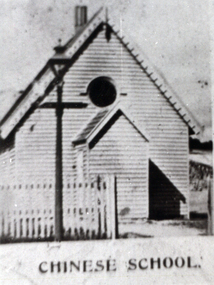
The Chinese School was attached/run by the Town Mission. "THE CHINESE SUNDAY SCHOOL . The opening services of the newly erected Chinese Sunday school building in connection with the Town Mission, were brought to a close on Monday night by a tea and public meeting, held in the Mission Hall. The now building, which presents a very nice appearance, and is an improvement to that part of the Main road, was erected at a cost of £95 ; Mr H. R. Caselli acting as honorary architect, kindly prepared plans, etc. A new front fence was erected at a cost of £l6, which, with all other expenses, amounted to £126 3s 6d. Previously to the present effort collections and subscriptions were obtained as follow; —Mr Burnett's service, £l8 11s 5d; Chinese Sunday school anniversary, £9 16s 10d; concert on Easter Monday, £8 15s; Phoenix Foundry, per Mr Pethard, £7; sub scriptions, £23 8s 6d, leaving a debtor balance of £57 7s 9d. The. collections on Sunday were good. Mr Lee Young, of the Chinese store, Main road, kindly gave the tea, whioh was a valuable donation. The proceeds of the tea meeting will be about £l0. The building was prettily decorated by Mr Chessell, Mrs King Hook, and the gir!s.connected with the sohool. Mr Moorshead, the caterer, gave all the school children tea gratis- Mrs Lee Young, Miss Emma Lee Young. Miss G. Kay, Miss J. Hong Gong, Mrs King Hook, Mrs Stoneman, and Mrs Pethard waited at tables. Mr M. D. Morgan presided at the public meeting in the Mission Hall, and was supported platform by the Mayor of Ballarat East, the Revs. J. White, J. J. Perrin, and E. Turner, who delivered excellent and suitable speeches; but previously, however, offers of donations - to clear off the debt were made by Mr D. Ham, £10; the chairman, £5; Mr and Mrs Whitrick, £2 17s; a number of donors of £1 each, and less sums, which, with the collec tions, amounted to £58 16s 7d. This sum, with the sale of the cottage.on the ground, clears the debt, and leaves the com mittee a few pounds in hand towards lining and seating the building. A pleas ing feature in the meeting was the hearty giving of several Chinese Christians, including Mr Le Young; also singing by the Chinese chil dren, led by Mr Pethard. When the result was made known tbe whole, meeting stood and sang —“ Praise God from whom all blessings flow," for the success in having the place opened free of debt. Votes of thanks were passed to Mr Caselli, and all who took part in the effort: and one of the happiest meetings ever hold by the mission was brought to a close by again singing the doxology and the benediction." Ballarat Star, 27 February 1885)Black and white image of a weather board school known as the Chinese School, Ballarat.chinese school, ballarat, ballarat town and city mission, chinese, education, school, chinese sunday school -
 Eltham District Historical Society Inc
Photograph - Digital Photograph, Alan King, Edendale Farm Homestead, 29 January 2008
Edendale Farm is Nillumbik Shire Council's environment centre situated in Gastons Road, Eltham between the railway and the Diamond Creek. The homestead on the property was built in 1896 and is of historical significance, being the subject of a Heritage Overlay under the Nillumbik Planning Scheme. The Edendale property was originally part of an extensive land purchase in 1852 from the Crown by pioneer Eltham farmer Henry Stooke. He initially purchased 51 acres and later expanded his holdings by purchasing another three adjacent Crown allotments extending northerly from Josiah Holloway's Little Eltham subdivision. Despite clearing the land, Stooke did not build on this property, choosing to live on his property "Rosehill" at Lower Plenty. In 1896 Thomas Cool, Club Manager of the Victoria Coffee Palace in Melbourne purchased 7 acres of the original Stooke land and built the house now known as Edendale. Cool did not farm the land, instead using it as a gentleman’s residence, retiring to Eltham at weekends. In 1918 he purchased an additional 7 acres but in 1919 he sold the property. Later owners included J.W. Cox, the Gaston family and D. Mummery. In the 1980s the Eltham Shire Council purchased the site for use as a Council depot, but this use did not proceed. Subsequently, it was used as the Council pound. The Edendale Farm Pet Education and Retention Centre was established in the summer of 1988/1989 and was set up to replace the existing dog kennels with a high standard pet retention centre. The design style of the building was established to compliment the features of the existing house. It was equipped with 10 retention pens, a veterinary room and a pet education area where school children and other interested parties learnt about pet care procedures. It was later developed into a community farm and was run by an advisory committee and in 2000 it became an Environment Centre. In early 2006 an advisory committee was established for the development of a master plan for future development at Edendale Farm. The committee included Russell Yeoman, a former long-time shire planner and founding member of the Eltham District Historical Society. At the time of filming the Master Plan and future for Edendale was about continuing to develop Edendale as a centre of environment learning and looking at expanding displays and school program, running a lot more of life-long learning and workshops around sustainable living. Covered under Heritage Overlay, Nillumbik Planning Scheme. Published: Nillumbik Now and Then / Marguerite Marshall 2008; photographs Alan King with Marguerite Marshall.; p101 A sharp turn from busy Wattletree Road by the railway line, brings a surprise. Only 1.4 km from Eltham’s centre, sheep feed, blissfully unaware of the hectic suburban activity so close by. At the entrance to the 5.6ha Edendale Farm is another surprise. A work of art that looks like huge tree trunks transformed into bowler and top-hatted men. The Fences Act 1968 by Tony Trembath with Mark Cain and John Doyle, 1996, is classified by the National Trust of Australia as having Regional Significance. The title refers to a government act on disputes between neighbors over the placement of fences and boundaries. This takes a ‘wry swipe’ at a community divided by trivial squabbles. It also celebrates making do with limited resources.1 Further along on the left, the office wall is decorated with a massive Eltham Copper Butterfly, designed by Robert Tickner and made by school children with used plastic bottles and other waste material. Nillumbik Council runs Edendale as an Environmental Education Centre, to help preserve and enhance the local environment. As early as 1988 the former Eltham Shire Council realised Edendale’s importance in meeting people’s needs, particularly of children, to enjoy farmland. The centre, with the Eltham North Reserve to the north - including remnant bushland and open parkland - makes up the major part of the public open space for this area. The council considers this area will become increasingly important to the local community for recreational use.2 Educational programs aim to encourage community involvement to ensure the long-term rehabilitation and protection of natural bushland areas. Edendale is used by people of all ages - from school children to adults - for environmental programs and workshops, as well as for recreation, to enjoy the domestic animals and to picnic. Edendale is also home to the Environmental Works staff who manage reserves and roadsides and support Nillumbik Friends environmental groups. The Friends propagate plants at the nursery, which grows indigenous plants and sells these to the public.3 The centre demonstrates the sustainable living the farm teaches, with features like solar hot water and drive lighting and for the fireplace, logs of recycled cardboard. Edendale has had a varied history as a dog pound and even as a retreat for Thomas Cool, Club Manager of the Victoria Coffee Palace in Melbourne. His single-storey weatherboard house built in 1896, which still stands, was grander than most homes in Eltham. Although such buildings were common in many other parts of Melbourne, Eltham’s poverty and remoteness did not encourage such construction. The Victorian rectangular-shaped house, with a corrugated iron roof and veranda, has elegant large rooms, leadlight windows, ceiling roses, two bay windows and ornately carved wooden fireplace surrounds. Cool bought seven acres (2.8ha) from pioneer Eltham farmer Henry Stooke’s 200 acre (81ha) farm, which he had bought from the Crown in 1852. In 1918 Cool bought an extra seven acres (2.8ha) but in 1919 sold the estate to farmer John Cox. In 1933 Cox sold Edendale to Mrs Elizabeth Gaston, after whom the road leading to the centre was named. The property was owned by several Gaston family members, who called it Edendale, then by a police constable, Douglas Mummery, until the Shire of Eltham bought it in 1970. Oddly Edendale was known as Mummery’s for almost 20 years, although Mummery owned it only for a short time.4 The shire used Edendale as a dog pound until amalgamation with other municipalities in 1996. The pound then moved to the Yan Yean Road, Plenty site, which had been used by the former Diamond Valley Shire Council. To the west and north the centre is bounded by Diamond Creek and on the east by the Melbourne-Hurstbridge railway line. Part of the Research creek forms the centre’s southern boundary.This collection of almost 130 photos about places and people within the Shire of Nillumbik, an urban and rural municipality in Melbourne's north, contributes to an understanding of the history of the Shire. Published in 2008 immediately prior to the Black Saturday bushfires of February 7, 2009, it documents sites that were impacted, and in some cases destroyed by the fires. It includes photographs taken especially for the publication, creating a unique time capsule representing the Shire in the early 21st century. It remains the most recent comprehenesive publication devoted to the Shire's history connecting local residents to the past. nillumbik now and then (marshall-king) collection, edendale farm -
 Phillip Island and District Historical Society Inc.
Photographs, Rose Series, Early 20th Century
Part of a collection of photographs donated by Bruce Bennett. Taken from different collections: Betty Kuc collection and Wal Steer. Most are photographs taken of postcards and photos.233-08. Black & White photograph of a postcard. Cowes Pier with shed, cranes and old Moonah tree in the foreground. 233-09. Black & White photograph of a postcard. Cowes Pier looking towards the east. Beach and foreshore in the foreground. 233-10. Black & White photograph reproduction of two young ladies in swimming costumes on Cowes Beach with pier in background. 233-11. Black & White photograph of a postcard. Cowes pier and Jetty shed, showing post and rail fence around entrance to pier. Tall Moonah tree near Jetty shed. 233-12. Black & White photograph reproduction of Genesta House with "Welcome Home" sign and Union Jack flags flying. Perhaps a welcome for local ment back home from the war?? 233-13. Black & White photograph reproduction of Genesta House in Cowes, Phillip Island. 233-14. Black & White photograph reproduction of Gullifer's Corner Store on the corner of Thompson Avenue & Chapel Street, Cowes Phillip Island. 233-15. Black & Whtie photograph of a gathering at the Cenotaph in Cowes, Phillip Island. 233-16. Black & White photograph reproduction of the Butcher Shop, Thompson Avenue, Cowes, near the old Shire Hall. 233-17. Black & White photograph reproduction of the lady on the rocks at Erehwon Point. Coastal vegetation behind the beach and two boats on the sand in the distance. 233-18. Black & White photograph reproduction of the Cowes Pier with masted ship and small boat at the pier. 233-19. Black & White photograph of the Garage Tea Rooms in Thompson Avenue, Cowes, with young cypresses which were planted circa 1915.233-08. The Rose Series P659. The Pier, Cowes, Phillip Is., Victoria. 233-09. The Rose Series P658. The Pier, Cowes, Phillip Is., Victoria. 233-11. The Rose Series P672. The Pier, Cowes, Phillip Is., Victoria. 233-16. Cowes - Jan. 1938 cowes pier phillip island, cenotaph cowes phillip island, gullifer's corner store cowes phillip island, garage tea rooms cowes phillip island, genesta house, genesta guesthouse, guesthouses cowes phillip island, erehwon point, cowes, a. smith garage tea rooms cowes phillip island, butcher shop cowes phillip island, bruce bennett, betty kuc collection, wal steer collection -
 Bendigo Historical Society Inc.
Photograph - HILDA HILL COLLECTION: BLACK AND WHITE PHOTOS, 1921
Hilda Hill Collection. Black and White Photos Total of 7 in subset, 3 containing images of Victorian Coastline in particular Pt Lonsdale and Queenscliff in 1921. Another has a family group on a property owned in Kyneton Victoria known as 'Durvol' in October 1920. Ken wearing a grey suit and sitting on a large stone in the garden stargazing, to his left is a short section of a picket fence and ornate corner post, large trees in the background. Four ladies standing on the rock as the seaside, Doreen, Nora, Lila, and Rita, all dressed in white, the second and third are carrying darker coloured coats on their arms, Queenscliff 1921.Leonie dressed in white and holding a black hat with both hands, background shows trellis and weather boards, left foreground may be heap of cut wood. Frank is sitting on steps dressed in white shirt, dark waistcoat, and dark trousers, background is brick wall and handrail attached to the steps. Four ladies in four wheel tourist coach owned by J. L. Priddle, the two at the front are both wearing white, lady to the left also is wearing a dark coat and scarf, the ladies at the rear are both wearing dark tops and the lady on the outer is wearing a white dress. The background appears to be covered on shrubbery. Four ladies sitting on the rocks at Queenscliff February 1921, Three of the ladies are dressed in white, one in a darker colour, all are wearing hats of similar design either black or white. Pone man dressed in a black suit with a white shirt and black tie, the three ladies are all wearing white blouses and darker dresses, the child at the front is dressed entirely in white, Merry??? Durvol October 1920.Hilda Hill Persdonal Collectionaustralia, history, port londsdale & queenscliff, hilda hill ? realted to frank a hill, stock and station agent and hill family real estate. family owned property out at eppalock. could this be where 'the ranch' property was located? -
 University of Melbourne, Burnley Campus Archives
Photograph - Colour and black and white photocopy and document, The Egg and Poultry Producer, The Macauley Family, 1872-2013
History and reminiscences with photocopied photographs and a newspaper article about the family and life at Burnley as children. John Macauley and son, Bill, lived at Burnley 1914-1972. History and reminiscences with photocopied photographs and a newspaper article about the family and life at Burnley as children. John Macauley and son, Bill, lived at Burnley 1914-1972. Egg Curators. (1) p.3(b) "Weigh-in at start of new Egg Laying Competition, c. 1940 with Bill and father John T. Macauley." (2) p.5(c) "P.R.L. 1960." Plant Research Laboratory. (3) p.5(d) "Path leading to Plant Breeding Plots. 1960." (4) p.7(a) 1959." (5) p.7(b) "Drive-Burnley Gardens 1949." (6) p.7(c) "Seed Testing Laboratory built 1966." (7) p.9 "1990's." Probably a bit earlier. (8) p.9 "2013." Actually pre 1991. (9) p.9 "Averil and Esmerelda 1959." (10) p.11(b) "1960 view showing 6 hen pens of Random Sample Laying Test. Residence (built 1960) at rear." (11) p.12(a) "1959 view of potting-shed/glasshouse on way to orchard." Note cactus collection. (12) p.12(b) "1960 view of 'Hydrangea Walk'-orchard fence on left." (13) p.12(c) "2013 view of path leading to the above pathway." (Hydrangea Walk.) (14) p.14 "Burnley Gardens Kneens house at rear 'Jack' 1960's." (16) p.14 "Horticultural College c.1967." (17) "The 'family' tree re-visited by Janice & Alison Downman Dec 1995." (18) Newspaper article, "Bill Macauley leaves the birds," from "The Egg and Poultry Producer" August 1972.family life, burnley, children, john macauley, bill macauley, egg curators, egg laying competition, plant research laboratory, janice downman (née macauley) -
 Royal District Nursing Service (now known as Bolton Clarke)
Photograph - Photograph, black and white, c.1905
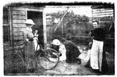
This photograph shows Melbourne District Nursing Society (MDNS) Trained Nurses (known as 'Nurse' in those days) attending to a family in the early 1900s. It also shows their uniform which had a red Maltese cross in the centre of the pith helmet. The bicycle seen is the first mode of transport purchased by MDNS in 1903. The Nurse's bag is seen strapped to the handles of the bicycle. In February 1885, 50 years after Melbourne was founded, it was recognized that nursing care was needed for the sick poor in inner Melbourne. The Melbourne District Nursing Society (MDNS), the first District Nursing Society in Australia, was founded and the decision was made to only employ fully qualified nurses who had trained in a Hospital. In those days they were known as 'Nurse'. One Trained nurse, was employed in March, and a second employed six months later. They worked in the now CBD, ie from Spencer Street to Spring Street and from Victoria Parade to Flinders Street. From its inception the Society was at the forefront of health care and only attended patients seen by a Doctor. They provided high quality nursing care; educated their patients in the curing and prevention of disease; teaching the importance of cleanliness, ventilation and good nutrition, both by verbal instruction and demonstration, even supplying soup and milk when needed. At that time they walked the streets and lane ways amid the slums of inner Melbourne carrying their nursing bag containing lotion, ointments, powders, liniment, bandages, dressings, a case of spirits, and the Nurse's own clean apron, soap and small towel. They supplied equipment on loan, such as earthenware hot water bottles, splints, urinals, bed pans, bed cradles, feeding mugs, and air-cushions as well as providing blankets and clean bed linen, and nightdresses as necessary. Trained midwives began home births in late 1893 taking midwifery bundles and providing clothes for the babe and mother as needed. This was arduous work, particularly in the heat of summer. Permission to use bicycles was given to the Nurses in 1898 and the Society decided to purchase their own in 1903. A business man offered ‘new free wheel’ bicycles at £13 each which included maintenance for one year. Bells and wooden frames were added, at a cost of £5 per frame, so the Nurses could carry extra equipment. Nurses’ bags were strapped to the handlebars. Soup was made for those in need 2-3 times a week and if patients could not arrange to have it collected the soup was delivered by the Nurses on their bicycles. The use of bicycles caused a change in uniform, with white pith helmets, and veils covering them and tied under their chin, now being used. Over the years the Nurses complained their veils became wet in the rain and asked for a change of uniform but this did not occur until 1921. Bicycles continued to be used in inner areas until 1945. The Nurses provided high quality nursing care to a range of people often in destitute situations, some lying on rags on the floor as they had no bed, others with just a bed and maybe a thin blanket, a chair and nothing else. Their ages ranged from babes, children, adults to the elderly. The Nurses gave medications as ordered by a Doctor, dressed wounds e.g. to the injured, and surgical cases, and to those with leg ulcers; attended to patients with ‘surgical ailments’ such as ‘hip disease’; gave care to those with acute illnesses such as bronchitis, pleurisy, pneumonia, measles, and scarlet fever, as well as those with chronic illnesses such as consumption (tuberculosis), heart disease, arthritis, cancer, debility, neuritis and paralysis. The Nurses liaised with the person's Doctor. They educated their patients, and their Carers, in the curing and prevention of disease; teaching the importance of hygiene, cleanliness, ventilation and good nutrition. They taught them, by verbal instruction and demonstration, how to make poultices, to make and apply bandages, apply medical appliances such as splints; and the Nurses supplied milk, beef tea and cooked soup when needed. As the work increased a third Nurse was employed but this was arduous work, particularly in the heat of summer and many Nurses only remained with the Society for several months. Black and white photograph of two Melbourne District Nursing Society (MDNS) Trained nurses, 'Nurse', wearing their full length grey uniforms, with white collar, cuffs and belt, and white pith helmets with a Maltese cross applied. One Nurse is standing and holding her bicycle, while the other is kneeling and holding a small child. They are in the garden behind a horizontal weatherboard house. A man dressed in dark clothes is also kneeling beside the child. There is a child, dressed in white, in the doorway of the home, and a lady, dressed in a full length black dress and a white apron, is standing in front of the wooden fence in the garden. The bicycle has two large wire spoked wheels at either end of the black V shape bicycle frame; a rubber tyre runs around the outside of each wheel. The metal handlebars are a horizontal configuration and are attached with a central column into a black vertical column at the front of the V shape bicycle frame which has ‘fork shaped’ thin metal pierces running down either side of the wheel attaching the frame to the central hub of the wheel. The rear wheel is attached the same way to a central column at the rear of the frame which runs up to V shape solid seat. At the bottom of the V of the frame a pedal is attached with a rotating arm on either side of the bicycle and on the right side the rotating arm is attached to a sprocket which has a chain running around it back to a smaller sprocket on the hub of the back wheel. The chain has a thin metal guard over it. There are narrow thin metal mud guards running a short distance above the top of each wheel.melbourne district nursing society, mdns, mdns uniforms, mdns transport, rdns, royal district nursing service -
 Ballarat Tramway Museum
Photograph - Colour Photograph/s, Carolyn Dean, Apr. 1999
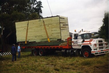
Set of 20 photographs taken by Carolyn Dean between 16/4/1999 and 16/5/1999 of moving the ex SEC bike shed to Bungaree and placing the roof back onto the shed and other works at Bungaree and one tram operation photo. On Kodak paper. 1095.1 - Loading the shed at Ballarat East - Alastair Reidier and Peter Winspur. .2 - ditto .3 - truck with shed on approach road to house. .4 - ditto and John Phillips .5 - lifting the shed into position at Bungaree over the power line. .6 - ditto .7 - lowering onto the foundations. .8 - tram 14 in Wendouree Parade near depot junction. .9 - Fixing hole in roof of the house - Bungaree - John Phillips .10 - ditto .11 - its snowing - Darren Hutchesson, Carolyn Dean, Alan Snowball - photo John Phillips .12 - putting roof back on the shed .13 - various cars out front of the house. .14 - nailing weather boards back on - Peter Winspur, Sftnon Jenkins, Alan Snowball .15 - ditto .14 used in the May 1999 Fares Please! .16 - fitting off purlins - Darren Hutchesson and John Phillips .17 - view of house and shed and partially painted fence looking south west. .18 - ditto looking south. .19 - fitting off the sheet metal - John Phillips .20 - cleaning up the tree in frost of the house from breaking off more branches - Alan Snowball and Alastair Reither. .1 > .7-16/4/1999: .8 - 25/4/1999: .9 > .16-15/5/1999: .17 > .20-16/5/1999. See also Reg. No. 1095 for next stage of the move.On rear of each photo in blue ink is date in the upper edge and on lower edge "Photo by Carolyn Dean"btm, sec bike shed, bungaree -
 Bendigo Historical Society Inc.
Photograph - HILDA HILL COLLECTION: BLACK AND WHITE PHOTOS, 1920
Hilda Hill collection. Combination of Sepia & Black & White Photos Total of 9. Photos. Five boys all dressed in white and wearing white boaters playing instruments in a band, left foreground Tuba, two in centre playing trombones, man in background playing smaller tuba like instrument, Clem Easter Fair procession1920. Four young ladies and four young men sharing a picnic at the lake, (Weeroona?), ladies wearing white or light coloured outfits and the men and boys all dressed in darker clothing, background left building on far side of the lake, at the lake 'Hungry' January 1920. Ken at Lockwood April 25th 1920, wearing white shirt dark waistcoat and trousers, left arm on top of gate post, two stays for the gate post and dry tree limb on ground, background open paddock with trees further in the background. Babe & Hilda at the Easter Fair 1920, Both wearing broad brimmed hats, one light the other dark, dark coat and skirt combinations with white accessories. 'the Three Graces' Queen street, April 25th 1920, 1 wearing dark suit and hat with white shirt and dark tie, centre wearing grey suit hat white shirt and dark tie also holding a ball his left hand round the shoulder of the man to his left, man on right wearing dark coat grey trousers white shirt and dark tie his left hand is holding round stick. Group of seated ladies, lady to left wearing light broad brimmed hat and white blouse holding bunch of leaves, next lady also wearing light broad brimmed hat dark dress white blouse with large collars folded over the coat lapel, and glasses, next at rear of group lady in hat white dress and dark coat left hand on shoulder of person left front of herself, This lady wearing dark wide broad brimmed hat dark coat and skirt with white blouse and also holding a bunch of leaves, last lady on right wearing a floppy brimmed hat with white blouse and dark coloured outfit with light coloured lapels, One Tree Hill April 18th 1920. Family group Lockwood April 25th 1920,some of the males are wearing hats others not, most are in dark coloured suits with or without coats, all of the ladies are wearing hats of varying kinds, all appear to have white blouses on with dark skirts or dresses, photo in open paddock with trees in the background. Girlie & Frank Queen street April 25th 1920, Girlie in foreground seated on rug of which more next to her is where Frank may sit, to her wearing glasses dark dress with white blouse and white hat, Frank wearing grey suit and hat is holding an object over the head of Girlie,background left a suitcase on the ground, centre background is a slim tree, right background house with gabled roof and bull nose verandah, high picket fence, trees on footpath. Left side buildings fronting the footpath. Babe seated on the hand rail at the bottom of wooden stair case, wearing broad brimmed hat dark dress and white blouse, shadow in foreground of the photographer and assistant, left is wire fence with wooden posts and top rail, April 1920.australia, history, post war life -
 Eltham District Historical Society Inc
Film - Video (VHS), Jenni Mitchell, Demolition of the Shire of Eltham Offices, 1996
Poor video quality (noise and interference), incomplete and unedited raw footage. A video documenting the demolition of the Shire of Eltham offices at 895 Main Road Eltham under the direction of the Commissioners appointed for the new Shire of Nillumbik and some of the communities activities surrounding the event. The building was demolished exactly 25 years after the southern wing housing Engineering and Planning on the upper level and the Eltham Library on the ground level was opened in celebration of the Shire of Eltham's centenary. Video has lots of distortion and noise, and sections of clips dubbed over. Immediate initial footage of Jenni Mitchell talking about asbestos claims in the Shire Offices (Sigmund Jorgensen standing behind her) advising Council did a review of the building several years previously and had been cleared of health problems. Cuts to group of people standing outside front door of offices but possibly voice dub over not related ? Then the date 27 Jul 1996 on a scene flashes on screen immediately followed by an edited clip intro of title and credits with classical music track. It then opens with Jenni Mitchell driving to the Shire Offices on Saturday 27 July 1996 at 11.00am. Footage of Main Road past Pitt Street, Alistair Knox Park then entering Shire Office driveway which is fenced off and contractor signs hanging up. Scenes at rear of building showing some internal demolition has commenced. View of the Administration wing. More clips of road driving, Alistair Knox Park, Eltham Library and visitor car park for Shire Offices. Cuts to a group of people standing in access to visitor carpark with new Eltham Library in background, one being immediate former Shire of Eltham President, John Graves. Scenes of people looking through chain link fence and security guard checking front door. John Graves being filmed that someone informed him the Shire was offering the building to the Community Health Centre for $2.3 million and that if they had been offered a price of $1.1 for what it apparently was sold for they would have snapped it up. View of truck loaded with brick rubble literally struggling to ascend the hill of Library Place to exit into Main Road. Cuts to a scene looking at Eltham War memorial Hall through the Memorial Gate, then the Shillinglaw trees and large banner sign ‘Delta Demolitions’ hanging on office façade. Views of front door, old library and bluestone wall. Scene (31 Jul 1996) filmed at night of several white crosses with “RIP Community” and “RIP Democracy”. Scene (1 August 1996) again driving along Main Road towards the Shire Offices then scenes of the offices showing substantially more demolition to exterior, groups of people standing on footpath outside watching, Delta heavy demolition machines, woman holding sign “Democracy where have you gone …”, the odd person in full protection gear and breathing apparatus hand carrying materials out to place on rubbish pile in front of people standing on footpath watching (with no protection) and then stamping on it to break it creating dust, security person in hard hat (no other protection) wandering around, many groups standing around watching, news film crew, person standing on roadside edge holding signs facing traffic stating “Pirate Planning” and “ Grant us your ears” also sign on back of parked car “Elthams High Jacks”, another sign “Community Democracy”, views of crosses in Main Road median strip “RIP Community”, groups of people on footpaths and reporters conducting interviews, footage of unknown person standing with Jenni Mitchell and Sigmund Jorgensen advising people have the right to protest, Jenni Mitchell urging people to ask questions of local MP and Council and Sigmund Jorgensen referring to the three historic Shillinglaw trees with demolition machinery operating in background, Jenni Mitchell and others installing more crosses in median strip; demolition machines operating inside and outside the building, more views of onlookers including Sigmund Jorgensen then Police approaching on footpath, workers and machinery continuing to operate, views of the old library being demolished, the former Community Services department, security personnel. Scene (2 August 1996) more heavy demolition machinery in operation smashing building up, people standing around southern wing watching, view overlooking Eltham Library of train pulling in to Eltham station. Scene (7 August 1996) more heavy demolition and people wandering around with only hard hat protection, no dust protection, comments from one operator dumping a bin of material stating “wait till there’s a Hungry Jack’s here, you’ll be laughing, fuel, videos, hamburgers. You’ll be up with the rest of the world soon, you’ll have electricity and everything here, ha ha ha ha”, more heavy machinery demolition and breaking up of materials, view of Hitachi train going by and Administration wing, view inside the front door opening of the staircase leading to upper level, person walking around operating heavy machinery with a hose spraying rubble (no protective gear other than hard hat interspersed with edit cuts of meeting of Commissioners and independent observers on panel as well as members of the community in public gallery. Nillumbik Shire CEO Barry Rochford addressing the meeting., Chief Commissioner Don Cordell directly addressing Jenni Mitchell with respect to permission to take photographs, Barry Rochford continues to address the question asked of Council about the valuation of the former Shire of Eltham Office building/site, public gallery calling out asking why was building demolished, what was the urgency. Scene (14 August 1996) views of southern wing, previous single demolition operator again mocking people filming, operators working in and around building, Shillinglaw trees and largely demolished front, heavy demolition equipment at work, piles of building rubble, hose spraying water over rubble, large trucks arriving for rubble removal and loading of truck. Scene (21 August) more of the same, building virtually down, Shillinglaw trees standing tall and alone, water spraying on rubble and wattle in bloom. Cuts to Council meeting with public onlookers. Barry Rochford walks out, Wayne Phillips addresses meeting explaining one or two people shouting, members of the community challenging Council (Commissioners) about why due process appear to have been subverted. Former Shire President Robert Marshall in public audience, cuts back to Shire office carpark entrance site and sign hung on fence in front of library “Think Again!” and people standing around observing awaiting a protest demonstration erecting a large sign on stilts stating “Shell No!”, people singing a revised version of God Save the Queen (God Save Us All), Sigmund Jorgensen in attendance, Jenni Mitchell, Sigmund Jorgenson and others address the protest crowd, followed by people mingling, music being played then people standing around the cleared site circumference all with arms linked (video very broken up with noise) then chants “Save the Gateway” and “No Shell for Eltham” and more music and singing “Put up a parking lot”. The crowd then proceeds to walk along the footpath of Main Road. Scene (15 Sep 1996) meeting at Montsalvat in Great Hall addressed by Sigmund Jorgensen discussing a recently published list of the Commissioner’s to senior Council Officers of banned Nillumbik people, others encouraging people to view proposed plans for the site and lodge objections. Specific issues regarding asbestos claims are also addressed. Harry Gilham addresses the meeting on the subject of the Eltham War Memorial and Memorial Gardens and how Council believe a roundabout in the vicinity is of greater importance. Views of various artworks on display (for auction) and music performance in the Barn Gallery. Meeting addressed by Sigmund Jorgensen discussing an appeal against Council granting a permit to Dallas Howgate to develop the site and that the Minister has called the matter in to be decided by the governing council. This is followed by an auction of paintings. 0.05 - Jenni Mitchel, Sigmund Jorgensen and Peter Doughtery in background. 0.18 - Jock Kyme in front of building – David Essex, Marg Johnson on his left-hand side. 5.34 - John Graves – ex Shire of Eltham Councillor and President. 9.02 - Unknown person being interviewed. 9.30 - Jenni Mitchell, unknown person, Mark Burns, community activist. 10.04 - Sigmund Jorgenson, Jenni Mitchell. 12.04 - Police members 21.33 - Nillumbik Council offices 7 August 1996 Barry Rochford CEO, Vin Heffernan Commissioner, Don Cordell Chief Commissioner, Kevin Abbott Commissioner, unknown person. 28.00 - Barry Rochford CEO 28.05 - Kahn Frankie - in commissioner’s seat after commissioners and council staff have vacated the council chamber. 28.26 - Wayne Phillips, State Liberal member for Eltham, addressing community in response to questions. 28.36 - Mark Burns, community activist addressing gallery. 28.48 - Ken Hines, ex Shire of Eltham Councillor and President. 29.34 - Ken Hines, ex Shire of Eltham Councillor and President standing, Robert Marshall, ex Shire of Eltham Councillor and President seated in front. 29.41 - Karen Gerhards, community activist. 30.06 - Marg Johnson with loud hailer, next to Jock Kyme, community activist. 31.32 - Marg Johnson with possibly Frank Burgoyne?, Sigmund Jorgensen, Jock Kyme. 35.35 - Harry Gilham at meeting at Montsalvat on 15 September 1996. 35.43 - Sigmund Jorgenson at lectern. 36.42 - Marg Jennings. 37.47 - Mark McDonald, Jim Connor, ex Shire of Eltham Councillor in background. 36.28 - John Cohen, ex Shire of Eltham Councillor and President. 38.56 - Ken Hines, ex Shire of Eltham Councillor and President. 41.11 - Harry Gilham, president of the Eltham District Historical Society. 43.55 - Sigmund Jorgensen in Long Gallery at Montsalvat, at start of the art auction to raise funds for community action. 45.50 - Unknown person conducting art auction. VHS Video cassette (poor quality) Converted to MP4 file format 45:01, 535MBvideo recording, 895 main road, alistair knox park, artworks, auction, barn gallery, barry rochford, community health centre, dallas howgate, delta demolitions, demolition, don cordell, eltham, eltham library, eltham shire office, eltham war memorial, eltham war memorial gate, eltham war memorial hall, great hall, harry gilham, jenni mitchell, john graves, library place, main road, memorial gardens, mervyn hannan, montsalvat, pitt street, protest, robert marshall, roundabout, shell oil, shillinglaw trees, sigmund jorgensen, sign, wayne phillips -
 The Beechworth Burke Museum
Audio - Oral History, Jennifer Williams, Gwen and Jack Scott, 24th February 2000
Jack Scott was born in Beechworth on the 24th January 1919 into a third generation Beechworth family who had migrated from Scotland, Cornwall and Ireland during the 1860s. Also present during the oral history recording is Jack’s wife, Gwen Scott. In 1878 Jack’s grandfather established the carrier business - R. Scott Carriers. Jack’s grandfather secured a contract with the Zwar Brothers' Beechworth Tannery to transport all goods between the tannery and train station via horse and cart. Jack’s father and uncle carried on the family business, before Jack and his brother eventually joined after the Second World War. The company expanded from a single horse and cart short route to multiple trucks operating interstate routes. Prior to joining the family carrier business, Jack on leaving school started work at the tannery and served in the air force during the Second World War. When asked about the working conditions at the tannery, Jack recalls while they did have union representatives, it was not particularly effectual. The union representatives were often placated by sharing multiple whiskies with the Zwar brothers when in their offices to discuss workers’ issues. Gwen’s father also worked for the tannery for a period of time, and she enjoyed the annual picnics the tannery provided for employee families. Both Jack and Gwen’s connections to the tannery reinforces the tannery’s role as a major employer and presence in the Beechworth community. Prior to marrying Jack, Gwen worked in a range of roles including at the Ovens and Murray Hospital for the Aged, managing the family home when her parents both worked during the Second World War, and apprenticed with her sister as a hairdresser. Jack and Gwen provide some insight into maternal health issues in brief discussions of hospital birthing trends and awareness of contraception and family planning. Both Jack and Gwen recalled attending the open-air cinema at ‘The Rock’ in their childhoods. Gwen remembers that the ‘elites’ would sit on chairs at the front, and Gwen’s family sat on a rug at the back, while Jack would jump the fence and get in for nothing. Jack and Gwen discuss attitudes towards both Chinese Australians and Italian migrants in Beechworth. They did not notice any racism and from their perspective felt they were accepted in the town. Jack did note that Italian employees lost their jobs at the tannery during the Second World War, but believed they all stayed within the area and found stonemason and concrete work in the interim. Jack socialised with members of the Italian community and joyfully recalled attending their homes for music nights with lots of drinking and instruments being played. This oral history recording was part of a project conducted by Jennifer Williams in the year 2000 to capture the everyday life and struggles in Beechworth during the twentieth century. This project involved recording seventy oral histories on cassette tapes of local Beechworth residents which were then published in a book titled: Listen to what they say: voices of twentieth century Beechworth. These cassette tapes were digitised in July 2021 with funds made available by the Friends of the Burke. Gwen and Jack Scott’s account of their lives in Beechworth is historically and socially significant to the cultural heritage of the region. Gwen and Jack in reflecting on their everyday experiences of operating a family business, availability of work, leisure opportunities, interaction with migrants, and access to maternal health care provide essential economic, social, and healthcare insights. Gwen and Jack Scott’s oral history recording is part of a larger collection of oral histories recorded by Jennifer Williams in 2000, collectively they provide invaluable insights into Beechworth during the 20th century, much of the information in these oral histories would be lost if not documented and missed in the interpretation of tangible objects. This is a digital copy of a recording that was originally captured on a cassette tape. The cassette tape is black with a horizontal white strip and is currently stored in a clear flat plastic rectangular container. It holds up 40 minutes of recordings on each side.Mrs Gwen and Mr Jack Scott jack scott, gwen scott, r. scott carriers, scott brothers, zwar brother's beechworth tannery, zwar tannery, beechworth tannery, ovens and murray hospital for the aged, benevolent asylum, open-air cinema, the rock cinema, italians beechworth, hospital births 1920s, wang tech, wangaratta tech, nell scott, jennifer williams, oral history, listen to what they say: voices of twentieth century beechworth, tannery union -
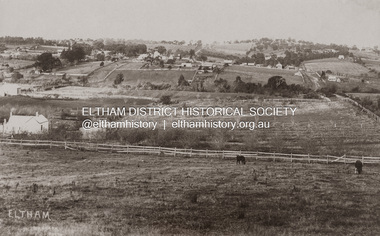 Eltham District Historical Society Inc
Photograph - Photograph postcard, J.H. Clark, Eltham (from Bolton Street), c.1915
Original sepia photo postcard of early view of Eltham looking east from Bolton Street between Bridge Street and Brougham Street (Wellington). Fenced road reserve on right is Brougham Street. Originally dated as pre-1877 introduction of the Telegraph (the Telegraph was connected to the Post Office on Thursday, June 7, 1877) given the lack of poles and wires visible, a more recent higher resolution scan has revealed more detail highlighting the presence of several Telegraph poles: one about half way between Brougham Street and Dalton Street, one opposite the Police Residence, another opposite W.B Andrew’s Corn Store (Zen Den site), one possibly near the Fountain/Evelyn Hotel. Also, given the photo was originally marked “J. H. Clark Photo” it is safer to assume the image is dated circa 1915 until dates of further image details can be confirmed. Photographer: J.H. Clark John Henry Clark was the youngest of three boys born to William Henry Clark (1823-1877) and Maria White (1843-1914). He and his brothers, William Charles Clark (1872-1945), Clement Kent Clark (1874-1912) operated a photography business (Clark Bros.) from 25 Thomas Street, Windsor near Prahran during the period c.1894 to 1914. Following death of Clement in September 1912 and their mother in 1914, the Clark Bros business appears to have dissolved, the premises demolished, and a new house was under construction in 1915. John set up business independently in 1914 operating out of 29 Moor Street, Fitzroy where he is registered in the 1914 and 1915 Electoral Rolls. By 1916 John had relocated to Eltham where he continued his practice as a photographer and took many of the early images around the district of Little Eltham. Around 1930 John changed professions and opened a small cobbler's shop in 1931 near the pond opposite Dalton Street adjacent to the Jarrold family cottage. He never married and continued his profession as a bootmaker from this little shop, maintaining a close relationship with Mrs Jarrold for the rest of their lives. His bootmaker shop remains today beside the Whitecloud cottage and is one of only three remaining shops in the area from the early 20th century. There are a couple of images of Eltham taken by Clark Bros. in the Eltham District Historical Society collection, one such example being Hunniford’s Post Office with Miss Anne Hunniford out front (EDHS_00140 - marked on the back of the print, Clark Bros., 25 Thomas St. Windsor), which would date this image between c.1894 and 1914. Other early images of Eltham taken by John Henry Clark are marked on the face “J. H. Clark Photo” and it is assumed these are dated between 1914 and 1930. It is noted that the Grant of Probate for John H Clark of Eltham South dated 5 April 1957 (513/387) records his occupation as "X Photographer".1. Original sepia postcard - water damaged lower left corner over approximate 30mm diameter destroying image and photohgrapher's markings (same as EDHS_00533 and EDHS_00535 - all from same donor collection) 2. A second black and white print copy of the same image from a different unknown source (of lower resolution quality) is also held. 3. A digital enhanced version has been created using the lower quality black and white print as a donor source for the damaged section of the postcard.In pencil on back of postcard: A. Petrie Verandah on Andrews shop Pearsons house (Living and Learning Centre)bolton street, brougham street, cafe zen den, courthouse, eltham courthouse, eltham hotel, eltham living and learning centre, eltham living and learning, eltham, fountain hotel, j.h. clark photo, knapmans forge, main road, maria street, pitt street, police residence, police station, post office, st margaret’s church, w.b. andrew corn store, wellington street, early eltham, little eltham -
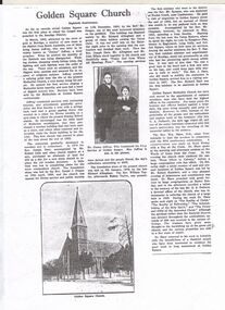 Bendigo Historical Society Inc.
Document - BARBARA MAMOUNEY COLLECTION: COPY OF PRINTED PAGE
Photocopy of a published page, marked as Eightieth Anniversary, relating to records as showing Golden Square as the first place in the Bendigo area at which the gospel was preached. On arriving from South Australia in 1852, attracted by the news of gold in the area James Jeffrey widely known later as Jimmy Jeffrey, a preacher who noticed that the sanctity of the Sabbath was being ignored, with normal chores and entertainment being the order of everyday. In short, little regard was shown for religion and there were no ministers. With a tree stump as his pulpit Jimmy began service by singing a Methodist hymn heartily, attracting a band of diggers to listen, with continuous services in Golden Square taking place ever since. Jeffrey continued with similar activities with increasing interest and attendances. Beginning with a tent surrounded by a fence a disused shed was bought and relocated to the site and was the finest building in the district. Late in 1852 the first real Church was erected in place of the shed and the tent. Enthusiasm and numbers of attendees swelled and in 1859 Reverend Joseph Dare and Robert Lisle and other church leaders purchased land (for 30 pounds) and had the foundation stone for a new Church building was laid by Reverend Daniel J.Draper on19th of April 1859 with Divine Service and Public Worship conducted from 11th December that year by Reverend Mr Draper. A collection on the day raised 262 pounds. The foundation stone for the present Church was financed by Richard Allingham laid on 5th January 1870. The first minister who went to the district was Reverend Mr Symonds who was stationed at Forest Creek near Castlemaine. Reverend Richard Hart was the first minister stationed at Golden Square. Embedded in the article is an image of Jimmy and Mrs Jeffrey. On the reverse of the article is a copy of a drawing by Reverend Aswel Aptel circa 1853.fra margolden square methodist church, wesleyan church, mamouney, church, richard allingham reverends jimmy jeffrey, william robert lisle robert draper, william taylor, symonds, j dare, chapman, hilson t raston, richard hart, wm shaw. g a pethard, robert saunders. reverse side a sketch of the church circa 1853 by aswel aptel. james cox (sec) mrs foot (teacher). -
 National Wool Museum
Textile - Community Textile Tapestry, Lisa Kendal et al, WARM, 2016
WARM was a community textile art project that saw over 250 knitters come together to create a beautiful collage tapestry. Made entirely from wool, the artwork contains more than 1000 individual hand knitted sections. The project takes aim at global warming, it highlights both the causes and solutions for us to create a sustainable and safe climate for future generations. Lisa Kendal, the co-creator of the project, said “One of the problems in the world is that we have forgotten how to warm ourselves with wool. We have become too dependent on fossil fuels (for heating)”. This is the key idea surrounding the project. WARM began as two large scale images created by Lars Stenberg. The first image is a landscape scarred by coal mining. The second image is the same landscape only many decades later. Regeneration and regrowth have taken over the landscape and hidden the past coal mine completely. In its place is a beautiful landscape including trees, native flowers, a lake, lots of greenery and wind turbines. From March to the end of August in 2016, knitters worked hard to create the over one thousand pieces that came together to form the final tapestry. The pieces were all designed by Fibre Artist Georgie Nicolson of Tikki Knitting Designs, who converted the second image of the healed landscape into patterns for the 250 plus knitters to follow. These patterns included unusual designs such as gum leaves, trees, native flowers and even the wind turbines. During several days of installation, the knitted pieces were stitched together by Lars Stenberg over a picture of the first image of the operational coal mine. They worked to create the second image of the renewed landscape; like an enormous collage. The WARM project was donated to the National Wool Museum in 2021. It was a much-loved hanging within the Ballarat Hospital for many years before coming to the museum. More information about the project can be found on the following website. http://www.seam.org.au/warm The tapestry is made from 1000+ hand knitted sections stitched together to make an image. In the foreground of this image is a large gum tree that stretches from the bottom left to the top right corner. The trunk of this tree follows the left edge of the tapestry, with foliage from the gum tree spanning its top border. The bottom third of the tapestry is predominantly green grass with yellow, pink and red flowers providing sporadic colour. The middle third encompasses a lake, with orange colours surrounding the banks of the water as opposed to the green grasses of the bottom third. To the right of the lake are wind turbines. The top third of the tapestry is blue sky with white clouds. It also contains the previously described gum tree leaves. Each piece of the tapestry is 100% wool and was hand knitted and stitched together. The Tapestry is accompanied by an oil painting on canvas. It is a painting that matches the tapestry and served as a template for the final tapestry. Finally, the tapestry is accompanied by another pointing on wood board. This final panting is of a coal mine. This is the setting before regeneration and regrowth have reclaimed this site, which is the theme captured in the final tapestry. In the foreground of the coal mine painting is the same gum tree described in the tapestry; however, it is grey and sickle with only 4 leaves visible at the top border, compared to the numerous leaves in the tapestry. Also in the foreground is a broken barb wire fence adding to the unwelcoming nature of the site. The colour scheme of this image is of dark greys and browns. A coal fired power plant can be seen in the final third of the image with four chimneys emitting plumes of smoke into the sky. In front of this power plant is the spiral shape of a coal mine, burrowing deep into the earth’s crust. Inside of the coal mine 3 yellow trucks are seen mining and transporting coal to the top of the mine.warm, community textile tapestry, knitting, community artwork, global warming -
 Royal District Nursing Service (now known as Bolton Clarke)
Photograph - Photograph, black and white, c.1960
This photograph shows the Melbourne District Nursing Service (MDNS), Headquarter and Nursing Home at 452 St. Kilda Road, Melbourne. The cars in front of the building are part of the MDNS fleet of cars and are Australian built Holden vehicles of the 1960s. The MDNS Trained nurses (Sisters) seen are wearing their grey uniform coats and hats which had a red Maltese cross in the centre front. Under their coats the Sisters wore grey cotton frocks. The Melbourne District Nursing Service (MDNS) building at 452 St. Kilda Road, Melbourne was originally called 'Airlie Mansion', the childhood home of Stanley Melbourne Bruce, the Prime Minister of Australia 1923-1929. 452 St. Kilda Road, Melbourne is listed on the Victorian Heritage Register. 'Airlie' was used by Queen Victoria Memorial Hospital nurses as a Nurses Home prior to Melbourne District Nursing Service (MDNS), moving into this building as their Headquarters and Nursing Home in 1953. MDNS was given Royal patronage in 1966 and continued to occupy the building as Royal District Nursing Service (RDNS) until 1996. Royal District Nursing Service (RDNS) has had various modes of transport over the last 130 plus years. At first, from 1885 as Melbourne District Nursing Society (MDNS), their Trained nurses (Nurses) walked the streets and lane ways amid the slums of central Melbourne. As the Society expanded public transport was used, and bicycles were bought by the Society in 1903 and used in inner areas until 1945. During the Spanish flu epidemic, in 1919, MDNS appealed for assistance to procure Motor vehicles so the Nurses could visit an influx of cases. Through trusts, grants and donations four 'Ford T Model' cars were procured which enabled the Nurses to triple their visits. Through constant use the cars were in such a poor state they were sold in 1927. A Motor Auxiliary was formed in 1929 to take Sisters to patients, and some Sisters used their own cars; even a motorcycle was used by one Sister in 1933. All these forms of transport were intermingled and in the early 1950s, and now as Melbourne District Nursing Service, seven Ford Prefect cars were bought followed by twelve Ford Anglia cars 1955. Having received Royal patronage; the now Royal District Nursing Service (RDNS) had its own fleet of Holden vehicles by the mid 1960s and the Motor Auxiliary ceased operating in 1971 as by then all staff employed were required to have a driving licence. Seat-belts had been introduced to Victoria in 1959 and District fitted them to their cars from 1962, even though they did not become compulsory until 1970. The Holden vehicles were replaced with grey Holden Torana vehicles. After several years the fleet was changed to white Toyota Corolla vehicles. The Melways Directory of maps was introduced in 1966, which was a boon to the Sisters though it was a few years before it went beyond Seville, so a large paper map was used by the Sisters visiting patients in the areas passed Seville. By 2009 there were 598 cars in the fleet and the Sisters travelled 9 million 200,000 kilometres – this is equivalent to 12 trips to the moon and back. Black and white photograph of two Melbourne District Nursing Service (MDNS) Holden vehicles parked outside MDNS Headquarters, which is seen in the background of the photograph. To the right is a MDNS Sister, who is wearing her grey peaked hat over her drawn back long hair. and is wearing her grey coat and carrying a square nursing case with the capital letters 'RDNS' written on it; she is standing side-on, looking to her left, and her right hand is on the door handle of the front door of the right hand car. To her left is another car, with a MDNS Sister standing on the grass behind the bonnet. She is wearing glasses and her uniform hat is worn over short dark hair. She is wearing a grey coat, scarf and both gloved hands are holding the handles of bags. On the drivers door of this car the words 'Melbourne District Nursing Service' are written in capital letters. On the far left hand side of the photograph, half of a third Holden vehicle is seen and a large tree is on the nature strip between this and the middle car. Behind the vehicles, bushes and a large tree can be seen on the left hand side behind the cast iron fence. Several other bushes and small trees are seen. In the background is MDNS Headquarters; a large white two storey Italian style building, which has three, roman column, arched Arcadia on either side of a polygon shaped bay window on the ground floor, and three long windows to the left and a three arched Arcade to the right on the second floor. Two Sisters in uniform are standing on the veranda of the 2nd floor between the far right hand arch. To the left and right of the building, parts of single storey hip roof buildings can be seen.melbourne district nursing service, mdns, rdns, royal district nursing service, rdns headquarters, rdns transport, mdns uniforms -
 Bendigo Historical Society Inc.
Photograph - HILDA HILL COLLECTION: BLACK AND WHITE PHOTOS, 1917-1922
Series of Black & White Photos Total 8 Hill Family & Friends during the final years of World War I and into the touring boom of the 1920s. Lady dressed in all white, with dark coloured scarf over her shoulder, parasol in her right hand, in conversation with The Dean January 28th 1918.Oval photo of young girl dressed in dark skirt and white blouse in bush setting with trees in background, photo not very clear, 'Durvol' Kyneton 1918. Mollie & Babe Railway Reserve Kyneton, girl in light coloured dress reclining on the ground, other girl in kneeling position wears dark skirt and white blouse, palm tree to the left background, further back is paling fence, shrubbery to the right background, 1918. Horse & 4 wheeled Gig, man seated wears a dark suit with white shirt and dark tie, horse appears to be a grey colour, background shows bull nose veranda roof and part of a house gable, tree in framework on nature strip. Nell wearing a dark skirt and white top, right hand touching a shrub, white structure in the background, 'The Ranch' Eppalock November 1918. Botanical Gardens group photo, six young ladies, one wearing a vertical striped dress, three wear dark dresses with white blouses, two wear white blouses and dark skirts, one black hat and three light coloured, light hat in right foreground, January 1919. Jack & Mick in dark suits, white shirts, striped ties, shrubbery in the background, long trousers 'The Ranch' Eppalock January 14th 1917. two young ladies in all white, one holding a hat, young boy in dark clothing white shirt and dark tie, holding long stick, large shrub in the background, 'The Pines' Kyneton January 1919.Hilda Hill Personal Collectionaustralia, history, post war life