Showing 4549 items matching "historical map"
-
 Creswick Campus Historical Collection - University of Melbourne
Maps, 1967 - 1972
Maps of various subjects: Gunbower Island 1972. Barmah Forest 1967. Survey maps from aerial photography 1971 _Narnargoon.Tonimbuk. Gilwell & Beenak.Maps -
 Creswick Campus Historical Collection - University of Melbourne
Map, Creswick, 1943
Dept of Lands and Survey map of Creswick and county of Talbot. 2 linen backed sheets rolled into white cardboard cylinderMaps -
Creswick Campus Historical Collection - University of Melbourne
Map, c.1930?
30 topographical maps, etc dating from 1930's. Subjects: Bendigo, Bendock, Castlemaine, Colbinabbin, Corio, Creswick, Dartmoor, Daylesford, Dunolly, Geelong, Gembrook, Glenmaggie, Juliet, Kaye, Maryborough, Murchison, Ringwood, Stratford, WalhallaMapsSchool of Botany, Univerity of Melbourne -
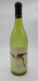 Hume City Civic Collection
Container - Bottle, wine, LONGVIEW CREEK/SUNBURY, 1994
The bottle was donated to the museum by Ron and Joan Parker for use in the exhibition ' A history of the Vineyards in Sunbury' held in the George Evans Museum in 1996. The vineyard was planted in 1992.Conventional bronze green glass bottle with indented base. Cream, gold & maroon printed labels. On the front there is a map impression of Longview Gorge in Sunbury. On the back there is geographical and historical information about the vineyard. There is black cap with a thin gold band at its base which covers the neck and opening of the bottle.Front label: " LONGVIEW CREEK / SUNBURY / PINOT NOIR / 1994 / Produce of Australia"; " S A A 5300" embossed on the glass around the base of the bottle.wines, wineries, longview creek vineyard, longview gorge, parker, joan, winemakers, hodgson, david, ron, george evans collection, 1990s -
 Stawell Historical Society Inc
Photograph, H.M.A.S. Stawell Corvett Class -- Tour of Duty Map
Corvette H.M.A.S. STAWELL Tour of Duty Mapstawell ww2 -
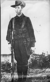 Stawell Historical Society Inc
Photograph, Mr Sydney Davidson as a Soldier in WW1 in uniform with rifle, webbing, & map case 1914-1918 -- Studio Portrait
Portrait Sydney Davidson 1914-18 Soldier WW1 in uniform with rifle webbing and map casestawell war -
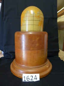 Stawell Historical Society Inc
Memorabilia - Realia, 1943
Lamp. Polished Wooden Base. World Map painted o Mercator's for projection. Timber from first Anglican Church.stawell, education -
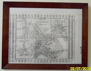 Sunshine and District Historical Society Incorporated
Map (1939), RAILWAYS OF VICTORIA, Including Passenger Mileage, 4 April 1939, 1939
Historical record of the railway line system in the state of Victoria in 1939. Many of the railway lines no longer exist.Map showing the RAILWAY LINES of VICTORIA plus PASSENGER MILEAGES as of 4.4.1939. The white map with black printing is enclosed within a glass faced brown stained wooden frame.victoria, railway map, 1939, rail, passenger mileage -
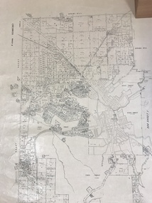
 Sunshine and District Historical Society Incorporated
Map (1967), CITY OF SUNSHINE, June 1967, 1967
... the larger City of Brimbank. This 1967 map is a historical record ...The City of Sunshine no longer exists. Part of the eastern area has been annexed by the City of Maribyrnong, and the rest of the old City of Sunshine has been amalgamated with the City of Keilor to form the larger City of Brimbank.This 1967 map is a historical record of the City of Sunshine as it existed 27 years before the amalgamation of Councils, and the creation of the City of Brimbank in 1994.Whitish paper map with black printing that is laminated in clear plastic film, and has a wood slat attached to the top edge. The June 1967 map is of the previous CITY OF SUNSHINE showing City and Parish boundaries, streets, railways, creeks, river etc.Purple ink stamps at top left hand and right hand areas showing address and contact details of 'Sunshine Industrial Promotion Centre.'city of sunshine, june 1967, map, city, parish, boundaries, brimbank -
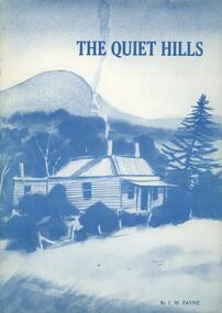 Nillumbik Historical Society Incorporated
Book - Softcover book, Doreen Primary School, The Quiet Hills, 1983
A history in recollections and photographs of the Doreen district of Victoria, AustraliaCover is card 300gsm with painting converted to blue tones on front and back with white semi gloss paper pages 100gsm - 37 pages plus 3 page index and maps on inside of front and back coversnon-fictionA history in recollections and photographs of the Doreen district of Victoria, Australia -
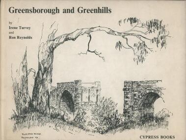 Nillumbik Historical Society Incorporated
Book - Hardcover book, Cypress Books, Greensborough and Greenhills, 1983
A history in recollections and photographs of the Doreen district of Victoria, AustraliaHardcover with linen finish and colour and no dust cover, paper pages 100gsm - 62 pages with etchings and a mapnon-fictionA history in recollections and photographs of the Doreen district of Victoria, Australia -
Clunes Museum
Document - BOOKLET & POSTCARDS, "THE DAY THE KELLY GANG PUT EUROA ON THE MAP"
BOOKLET ISSUED BY THE EUROA HISTORICAL SOCIETY INC..1 BOOKLET ON THE KELLY GANG HOLDING UP THE NATIONAL BANK AT EUROA - DECEMBER 10TH 1878. .2.3 TWO SEPIA POSTCARDS OF THE EUROA BANK WITH SEVERAL POLICE AND LOCALS STANDING ABOUT THE FRONT OF THE BUILDING .4 POSTCARD DEPICTING SOUVENIRS THE SERVICE CARD OF ROBERT DAVID BOOTH DATED MAY 1877 WITH INSET IMAGES OF A LEAD BALL AND A DISFIGURED SIXPENCElocal history, books, history, local history., euroa museum -
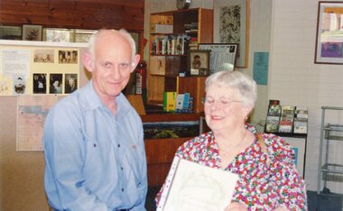
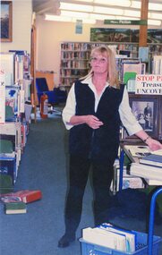
 Stawell Historical Society Inc
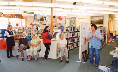
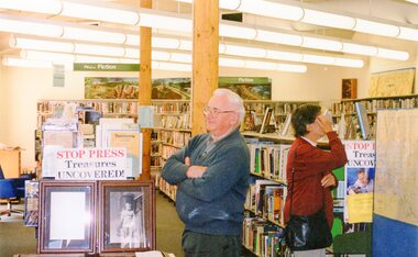
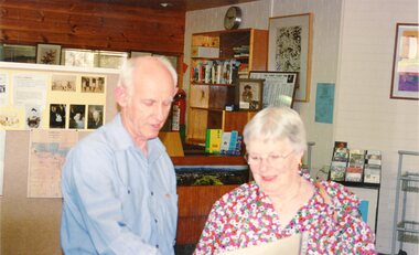
Photograph, Stop Press Treasures Uncovered
7151: A GROUP OF PEOPLE IN THE LIBRARY. 7151-1: TWO PEOPLE, THE MAN FACING LEFT THE WOMAN FACING RIGHT LOOKING AT A MAP. 7151-2: TWO PEOPLE STANDING IN FRONT OF A FAMILY HISTORY, READING A PAGE IN PLASTIC SLIP COVER. 7151-3 SIMILAR TO PREVIOUS BUT SHOWING PAGE TO CAMERA. 7151-4 A WOMAN STANDING IN FRONT OF PLASTIC CONTAINER. 7151-5 SIMILAR TO PREVIOUS BUT HOLDING A PIECE OF PAPER. 7151-6 SIX PEOPLE SITTING DOWN, THREE ON RIGHT, THREE ON LEFT. 7151-7: TWO WOMEN ON SITTING HOLING A CERTIFICATE.7151-1, 7151-4,7151-5 'Stop Press Treasures Uncovered' Stop Press in Redbiarri -
 Wonthaggi & District Historical Society
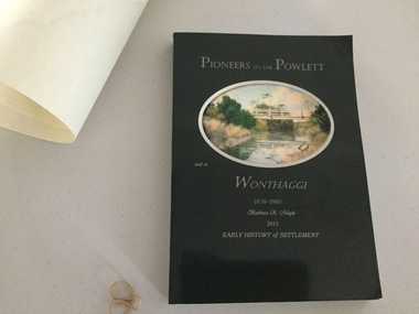
Book and Map, Barbara Moyle, Pioneers on tthe Powlett and at Wonthaggi 1878-1910, 2015
Book - families social histories, maps, photograps Map - block numbers town names physical / geographical featuresFarming and social history of pioneers of the Powlett River are prior to the establishment of the State Coal Mine at Wonthaggi. Significant land marks, buildings and photographs are included. Dark green cover with oval artists impression of Powlett river and bridge Associated map which covers the parishes plus key places of interestlPioneers on the Powlett and at Wonthaggi 1878-1910 Barbara R Moyle 2015 Early History of Settlement Map - Parish names, significant sitesfarming, pioneers of wonthaggi and district, wonthaggi families -
Stawell Historical Society Inc
Map, Stawell Gold Mines Pty Ltd, Plan of Magdala Mine. May 1994, May 1994
Moonlight Junction, Big Newington Co. Pleasants Creek and Newington, Prince Patrick, North Cross Extended, Prince Alfred, Robson and Party, North Magdala, Galatea and Pioneer Co., Duke Magdal, Moonlight, Moonlight Extended, Sliding Shaft, Extended Cross, Crown Cross United, Great Northern, Sloanes and Scotchmans, Marinees, North Waterloo, Scothmans United, Waterloo, Scotchmans Iron Duke and Bulcher, Perthen Shire, Prince of Wales, Roberts, Shafts of Rose of Denmark, Emerald Isle Shafts, O'Donnels, Darlington,, Albion, Federal, Ulster, Goldenpoint and Wexford.AO Printed Map In Colour. Showing Underground Workings and PortalScale 1 : 2500 -
Stawell Historical Society Inc
Map, Stawell Gold Mines, Plan View of Township Area Showing Known Old Workings. 2003, 13/06/2003
Two AO Maps that Overlap Showing Old workings on Map of Town North of Patrick StreetScale 1 : 5000 -
Stawell Historical Society Inc
Document - Report, Nicole Start, Conservation Status of Roadsides in the Shire of Stawell, 1991
Covers: Shire, roadsides, Assessment: Species, Flora, Grazing, Cropping, Gravel, Noxious weeds, Firebreaks, Road Design. With loos maps X 2 in back. Author Nicole StartPlastic Front Cover. Yellow Paper with Photo of a country road.Nicole Start Biological and Chemical Sciences Ballarat University Collage December 1991 -
Stawell Historical Society Inc
Book - Family History, Reading Family History 1826 - 2001, March 11 2001
Updated family HistorySoft cover - Yellow - Red Script Title. UK Map in Red - Journeyline in red. Australa Map in Red.Oct 2004. Donated to Stawell Biarri Group for Genealogogy Inc. by Mrs Isobel Reading -
Stawell Historical Society Inc
Archive, Great Western Cemetery Records. Names of Burials Recorded, 1860
Death Certificates Inquests Register MapPhotocopied Lots of Burials at Great Western Black Lever Arch, Plastic Inserts with paper Records. Cemetery Map Death Certificates, Inquests, Cemetery Registercemetery -
Stawell Historical Society Inc
Archive - Maps, Victorian Government, Bailliere's Country Atlas of Victoria, 1866
Stawell is on Wimmera & Loddon MapLarge Boxed Volume of Maps in Book Burgandy Coloured BoxUnder the Supervision of the Mining and Survey Department -
Stawell Historical Society Inc
Map - Laminated Map, Country Fire Authority, Mt Lubra and Deep Lead Fires Estimated Perimeters 2005 - 2006, 17/3/2006
Huge Fire Event in Grampians started by lightning strike at Mt Lubra on 19/1/2026 during a prolonged dry period. Stawell Deep Lead fire 31/12/2005 just three weeks earlier. Two people died on Moyston / Pomonal Road. Huge stork and feed loss.Coloured Laminated Map of Fire SpreadCFA GIS Services Community Safety -
Stawell Historical Society Inc
Map - Plan, Glenorchy Cemetery, c 1960
Printed map of plots on backing cardScale 1 inch to 12 feetburials -
Stawell Historical Society Inc
Book - Family History, The Clan McKellar by Keith Ormsby, 1989
Donated to Stawell Biarri Sept 2010Soft Cover, Yellow Black Print Brown Line Drawing, Maps of UK and Australia encircled by Semi Circle and Gumnuts, Leaves and Crock dash for travelsBiarri Logo -
Stawell Historical Society Inc
Archive - News Paper Article, Newspaper p18 Rupanyup in Rich Wheat Country, May 20 1953
Page 18 Weekly Times May 20 1953. Page of Photo's Basic map -
Stawell Historical Society Inc
Map, CFA, Map of Stawell / deep Lead Fire of 31/12/2005, 2006
Fire Started from lightning strike near Deep Lead and Burned on New years Eve with nasty North Wind, Southerly to Black range, Then Easterly towards Great western. Fire Subduded by Rain Event on 2/1/2006.Laminated Coloured Map of Stawell / Deep Lead 4/1/2006 with Fire Perimeters.CFA GIS Services Community Services -
Stawell Historical Society Inc
Book - Military Atlas, First World War Atlas, 1970
History of first war through Maps, Intro by Field Marshal Viscount Montgomery OG Alamein, KG Cartography by Arthur Banks Text by Martin Gilbertpaperback, covered in clear contact, white wig green square and red circle with gridDonated to Stawell Biarri group for genealogy inc 4/3/2009 by John Wynd Galen Champgnat Colege Library Wangarattafirst world war cartography history -
 Stawell Historical Society Inc
Photograph, Stop Press Treasures Uncovered
7151: A GROUP OF PEOPLE IN THE LIBRARY. 7151-1: TWO PEOPLE, THE MAN FACING LEFT THE WOMAN FACING RIGHT LOOKING AT A MAP. 7151-2: TWO PEOPLE STANDING IN FRONT OF A FAMILY HISTORY, READING A PAGE IN PLASTIC SLIP COVER. 7151-3 SIMILAR TO PREVIOUS BUT SHOWING PAGE TO CAMERA. 7151-4 A WOMAN STANDING IN FRONT OF PLASTIC CONTAINER. 7151-5 SIMILAR TO PREVIOUS BUT HOLDING A PIECE OF PAPER. 7151-6 SIX PEOPLE SITTING DOWN, THREE ON RIGHT, THREE ON LEFT. 7151-7: TWO WOMEN ON SITTING HOLING A CERTIFICATE.7151-1, 7151-4,7151-5 'Stop Press Treasures Uncovered' Stop Press in Redbiarri -
 Stawell Historical Society Inc
Photograph, Stop Press Treasures Uncovered
7151: A GROUP OF PEOPLE IN THE LIBRARY. 7151-1: TWO PEOPLE, THE MAN FACING LEFT THE WOMAN FACING RIGHT LOOKING AT A MAP. 7151-2: TWO PEOPLE STANDING IN FRONT OF A FAMILY HISTORY, READING A PAGE IN PLASTIC SLIP COVER. 7151-3 SIMILAR TO PREVIOUS BUT SHOWING PAGE TO CAMERA. 7151-4 A WOMAN STANDING IN FRONT OF PLASTIC CONTAINER. 7151-5 SIMILAR TO PREVIOUS BUT HOLDING A PIECE OF PAPER. 7151-6 SIX PEOPLE SITTING DOWN, THREE ON RIGHT, THREE ON LEFT. 7151-7: TWO WOMEN ON SITTING HOLING A CERTIFICATE.7151-1, 7151-4,7151-5 'Stop Press Treasures Uncovered' Stop Press in Redbiarri