Showing 19145 items matching " coast"
-
 Flagstaff Hill Maritime Museum and Village
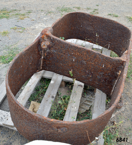
Mast Collar, c. 1886
The husband of the donor of this mast collar chanced to be staying a night at a motel in Peterborough, along the Great Ocean Road in Victoria. He had a keen interest in maritime items and recognise the mast collar at the motel’s back fence line. The motel owner told his guest the story of a customer, a doctor, who had organised and paid for divers to raise the mast collar from a local shipwreck, the Falls of Halladale. Shortly afterwards the doctor passed away, so the mast collar had remained at the motel site. The owner was leaving the motel the following week and wasn’t at all interested in the artefact. He was very happy for his guest to remove it. It took five men to load the mast collar up for the trip to the new owner’s two storey shed in Ballarat. It stayed there undercover, in the company of his collection of 5 buggies, for the next 40 or so years until the property was for sale. A friend, who realised the significance of the mast collar, suggested that it be donated to Flagstaff Hill Maritime Village where other artefacts from the Falls of Halladale, such as the slate tiles, were on display. This mast collar, or masthead, from the Falls of Halladale would have been used to join two sections of one of the tall masts. As sailing ships became larger there was a need for taller masts or spars, which became difficult or impossible to find. To overcome this problem mast was divided into sections; lower and top or upper mast (on some of the ‘tall ships’ a mast could be divided into three or even four sections). The Falls of Halladale was a four-masted British barque built-in 1886. On what turned out to be her fatal journey, she had left New York for Melbourne in late 1908. She ran aground on a reef close to the shore west of Peterborough, South West Victoria, on November 14th. All 29 crew eventually landed safely onshore. The wrecked ship stayed on the reef for several months as locals watched the sails slowly deteriorate. The salvaged cargo included slate tiles, as mentioned above, and many of these have been used on the roof of buildings at the Flagstaff Hill Maritime Village. The iron-hulled, four-masted barque, the Falls of Halladale, was a bulk carrier of general cargo. She left New York in August 1908 on her way to Melbourne and Sydney. In her hold, along with 56,763 tiles of unusual beautiful green American slates (roofing tiles), 5,673 coils of barbed wire, 600 stoves, 500 sewing machines, 6500 gallons of oil, 14400 gallons of benzene, and many other manufactured items, were 117 cases of crockery and glassware. Three months later and close to her destination, a navigational error caused the Falls of Halladale to be wrecked on a reef off the Peterborough headland at 3 am on the morning of the 15th of November, 1908. The captain and 29 crew members all survived, but her valuable cargo was largely lost, despite two salvage attempts in 1908-09 and 1910. ABOUT THE ‘FALLS OF HALLADALE’ (1886 - 1908) Built: in1886 by Russell & Co., Greenock shipyards, River Clyde, Scotland, UK. The company was founded in 1870 (or 1873) as a partnership between Joseph Russell (1834-1917), Anderson Rodger and William Todd Lithgow. During the period 1882-92 Russell & Co., standardised designs, which sped up their building process so much that they were able to build 271 ships over that time. In 1886 they introduced a 3000 ton class of sailing vessel with auxiliary engines and brace halyard winches. In 1890 they broke the world output record. Owner: Falls Line, Wright, Breakenridge & Co, 111 Union Street, Glasgow, Scotland. Configuration: Four masted sailing ship; iron-hulled barque; iron masts, wire rigging, fore & aft lifting bridges. Size: Length 83.87m x Breadth 12.6m x Depth 7.23m, Gross tonnage 2085 ton Wrecked: the night of 14th November 1908, Curdies Inlet, Peterborough south west Victoria Crew: 29 The Falls of Halladale was a four-masted sailing ship built-in 1886 in Glasgow, Scotland, for the long-distance cargo trade and was mostly used for Pacific grain trade. She was owned by Wright, Breakenridge & Co of Glasgow and was one of several Falls Line ships, all of which were named after waterfalls in Scotland. The lines flag was of red, blue and white vertical stripes. The Falls of Halladale had a sturdy construction built to carry maximum cargo and able to maintain full sail in heavy gales, one of the last of the ‘windjammers’ that sailed the Trade Route. She and her sister ship, the Falls of Garry, were the first ships in the world to include fore and aft lifting bridges. Previous to this, heavily loaded vessels could have heavy seas break along the full length of the deck, causing serious injury or even death to those on deck. The new, raised catwalk-type decking allowed the crew to move above the deck stormy conditions. This idea is still used today on the most modern tankers and cargo vessels and has proved to be an important step forward in the safety of men at sea. On 4th August 1908, with new sails, 29 crew, and 2800 tons of cargo, the Falls of Halladale left New York, bound for Melbourne and Sydney via the Cape of Good Hope. The cargo on board was valued at £35,000 and included 56,763 tiles of American slate roofing tiles (roof slates), 5,673 coils of barbed wire, 600 stoves, 500 sewing machines, 6,500 gallons of oil, 14,400 gallons of benzene, plumbing iron, 117 cases of crockery and glassware and many other manufactured items. The Falls of Halladale had been at sail for 102 days when, at 3 am on the night of 14th November 1908, under full sail in calm seas with a six knots breeze behind and misleading fog along the coast, the great vessel rose upon an ocean swell and settled on top of a submerged reef near Peterborough on the south-west Victoria’s coast. The ship was jammed on the rocks and began filling with water. The crew launched the two lifeboats and all 29 crew landed safely on the beach over 4 miles away at the Bay of Islands. The postmistress at Peterborough, who kept a watch for vessels in distress, saw the stranding and sent out an alert to the local people. A rescue party went to the aid of the sailors and the Port Campbell rocket crew was dispatched, but the crew had all managed to reach shore safely by the time help arrived. The ship stayed in full sail on the rocky shelf for nearly two months, attracting hundreds of sightseers who watched her slowly disintegrate until the pounding seas and dynamiting by salvagers finally broke her back, and her remains disappeared back into deeper water. The valuable cargo was largely lost, despite two salvage attempts in 1908-09 and 1910. Further salvage operations were made from 1974-1986, during which time 22,000 slate tiles were recovered with the help of 14 oil drums to float them, plus personal artefacts, ship fittings, reams of paper and other items. The Court of Marine Inquiry in Melbourne ruled that the foundering of the ship was entirely due to Captain David Wood Thomson’s navigational error, not too technical failure of the Clyde-built ship. The shipwreck is a popular site for divers, about 300m offshore and in 3 – 15m of water. Some of the original cargo can be seen at the site, including pieces of roof slate and coils of barbed wire. This mast collar is significant due to its association with the ship FALLS OF HALLADALE, which is listed on the Victorian Heritage Register, VHR S255 The Falls of Halladale shipwreck is listed on the Victorian Heritage Register (No. S255). She was one of the last ships to sail the Trade Routes. She is one of the first vessels to have fore and aft lifting bridges. She is an example of the remains of an International Cargo Ship and also represents aspects of Victoria’s shipping industry. The wreck is protected as a Historic Shipwreck under the Commonwealth Historic Shipwrecks Act (1976). Mast collar, steel, salvaged from the shipwreck FALLS OF HALLADALE, wrecked off the coast of Peterborough, South West Victoria. Oval shaped a band of metal with a straight band of same heights attached between the long sides. Two metal loops are attached to the outside of the oval shape, next to the crossing band. flagstaff hill, warrnambool, shipwrecked coast, flagstaff hill maritime museum, maritime museum, shipwreck coast, flagstaff hill maritime village, great ocean road, falls of halladale, shipwreck peterborough vic, sailing ship mast collar, masthead of sailing ship, falls of halladale mast collar, masthead, mast collar, ship rigging 1908, russell & co. -
 Bendigo Military Museum
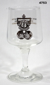
Souvenir - SHERRY GLASS, Rats of Tobruk Association
Dean Collection, refer Cat No 4575PPlain glass with stem. It has the logo of Rats of Tobruk Association along with a pair or world spheres. On the reverse side is the phrase: "Rats of Tobruk Association, World Reunion 1983, central Coast Sub branch NSW". The writing is gold colour.Nilwar, rats of tobruk association -
 National Vietnam Veterans Museum (NVVM)
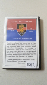
Film - Film, DVD, Year of the Road Runner
A Film, DVD in case named "A" Field Battery RAA. Red & Blue colours with a shield with the words 'Semper Paratus' (US Coast Guard song). Year of the Road Runner & description of contents of Film, DVD which runs 40 minsfilm, dvd, field battery raa -
 Glenelg Shire Council Cultural Collection
Photograph - Photograph - Cape Bridgewater, n.d
Black and white photo of waves breaking against the base of rocky cliff at Cape BridgewaterBack: 'Scene Cape Bridgewater' - handwritten in black inkcape bridgewater, seascape, coast -
 Ballarat Heritage Services
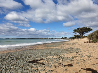
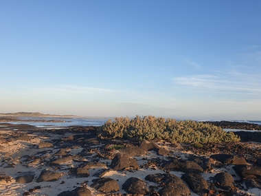
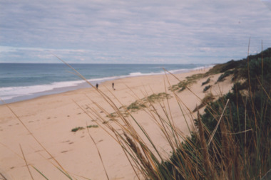
Photograph, Clare Gervasoni, Apollo Bay, 19/09/2020
Colour photograph of the beach at Apollo Bay.apollo bay, beach, coast -
 Ballarat Heritage Services
Photograph - Photograph - Colour, Clare Gervasoni, Killarney Beach, Victoria, 26/12/2019
Killarney Beach is located at the end of Mahoney's Road. It is sheltered from wave action by offshore reefs. Panoramic photograph of Killarney Beach, Victoria.killarney beach, coast, beach -
 Ballarat Heritage Services
Photograph - Photograph - Colour, Clare Gervasoni, Killarney Beach, Victoria, 26/12/2019
Killarney Beach is located at the end of Mahoney's Road. It is sheltered from wave action by offshore reefs. Colour photograph of Killarney Beach, Victoria.killarney beach, coast, beach -
 Ballarat Heritage Services
Photograph - Colour, Clare Gervasoni, Killarney Beach, Victoria, 26/12/2019
Colour photograph of Killarney Beach, Victoria at dusk..killarney beach, coast, beach -
 Lakes Entrance Historical Society
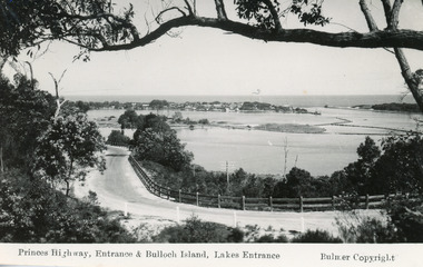
Postcard - Bullock Island, Bulmer H D, 1930C
2x black and white small format postcards both 6x9|1x tinted small format postcard 6x9|All above show inscription 'Road and Entrance'Black and white postcard of Princes Highway, entrance and Bullock Island taken from Kalimna Hill Lakes Entrance, VictoriaPrinces Highway, Entrance and Bullock Island, Lakes Entrancecoast, fences, roads and streets -
 Lakes Entrance Historical Society
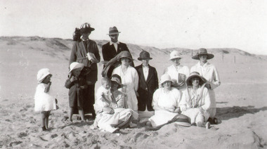
Photograph - Harbeck Family, 1924
Black and white photograph of members of the Harbeck family on the bare sand dunes at Lakes Entrance Victoria showing nine adults and three infants.coast, genealogy, recreation -
 Lakes Entrance Historical Society
Photograph - The Entrance, 1930 c
Black and white photograph of the Princes Highway at Jemmys Point, showing post and rail fence beside road, Bullock Island, the houses of Carpenter town on the southern shore of Cunninghame Arm and Entrance. Lakes Entrance VictoriaLakes Entrance- Gippsland Lakes'coast, fences, roads and streets -
 Lakes Entrance Historical Society
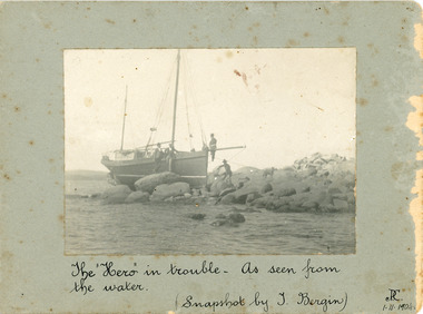
Photograph - Hero, 1904
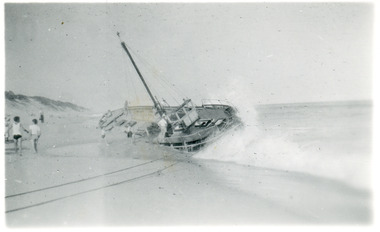
The date on the photo 1.11.1904, appears to identify this as 'Hero' supposedly lost October 1904 when her cables parted while sheltering from a gale near Cape Woolamai, Victoria. Eventually lost Gabo Island 1905.Black and white photograph mounted on card showing sailing boat Hero aground on rocks Lakes Entrance Victoria 1.11.1904. The "Hero" in trouble as seen from the water Snapshots by Burgin shipwrecks, coast, boats and boating -
 Lakes Entrance Historical Society
Photograph - Janet 1, Hammarstrom Ian, 1989 c
Colour photograph taken from a distance, showing the fishing boat Janet 1, stuck on the bar at Lakes Entrance, Victoria.ships and shipping, fishing industry, coast -
 Lakes Entrance Historical Society
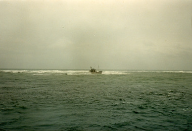
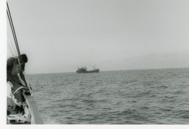
Photograph - Fishing Industry, 1975
Black and white photograph of a distant view of an unidentified fishing boat in Bass Strait, taken from a fishing boat on which a crew member gutting a fish. Bass Strait Victoriatopography, coast, ocean -
Lakes Entrance Historical Society
Book, Da Costa, Grant, Car Touring and Bush Walking in East Gippsland, 1988
Comprehensive guide to the magnificent forests and coastal areas of East Gippsland, Victoria, including twenty seven maps and notes on seventeen car tours, fifty nine locations of outstanding impact and 45 bushwalks. Illustrated with coloured photographicnatural history, vegetation, coast -
 Lakes Entrance Historical Society
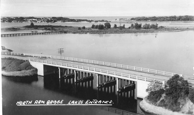
Postcard - North Arm bridge Lakes Entrance Victoria, The Lakes Studio, 1947
Also identical image, good condition, clearer print, collected, also enlargement 16 cm x 25.5 cmBlack and white postcard taken from the path up Kalimna Hill, showing the concrete North Arm bridge; Bullock Island; New Works area and Western side of Entrance. Lakes Entrance VictoriaNorth Arm Bridge Lakes Entrancewaterways, bridges, coast -
Lakes Entrance Historical Society
Book, LERHS members, Foreshore Development, 2002
A folder of clippings from local newspapers showing the development of the foreshore to enhance the landscape and provide recreation areas for the general public Lakes Entrance Victoriajetties, coast, environment -
 Lakes Entrance Historical Society
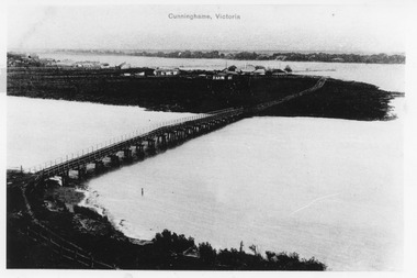
Photograph - Norm Arm bridge, Lakes Entrance Victoria c1900, 1900c
Black and white photograph of the bridge over the Norm Arm, showing the town of Cunninghame, including the Club Hotel, the sand hummocks and Cunninghame. Lakes Entrance VictoriaCunninghame Victoriabridges, township, coast -
 Lakes Entrance Historical Society
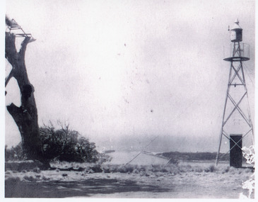
Photograph - Jemmys Point, 1925
Plus 1 x black and white small format photograph 6.5 x 6.5 taken from lookout, has signal light only|Plus 3 x small format postcards 6.5 x 8.5 taken from lookout, signal light quite distinct, with inscription Lookout Lakes EntranceBlack and white photograph of the entrance, taken from Jemmys Point between the old lookout tree and the signal light. Lakes Entrance Victoria coast, navigation, waterways -
 Lakes Entrance Historical Society
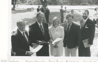
Photograph, Lakes Post Newspaper, Victorian Coastal strategy draft plan for Eastern Beach Lakes Entrance Victoria, 1/12/1996 12:00:00 AM
Black and white photograph of Robert Fordham,Chairman Vic Coastal Council, Duncan Malcolm, Diane James Acting Chairman Vic Coastal Council, Philip Davis Gippsland Province MLC, Fred Herbert Gippsland Coastal Council taken during launch of Victorian Coastal strategy draft plan for Eastern Beach taken in Lions Park Lakes Entrance Victoriacoast, environment, volunteering -
 Lakes Entrance Historical Society
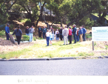
Photograph, John Street Rain Forest Revegetation Reserve, Lakes Entrance Victoria, 2000 c
Colour photograph of about 20 local residents listening to Bill Peel at the proposed John Street Rain Forest Revegetation Reserve John Street Lakes Entrance Victoriacoast, environment, people -
 Lakes Entrance Historical Society
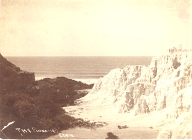
Photograph, A Davis Eden, Pinnacles Eden N.S.W, 1940 c
Sepia toned photograph showing a view of the ocean from the spectacular cliffs known as the Pinnacles Eden N.S.W.The Pinnacles Edencoast, ocean, topography -
 Lakes Entrance Historical Society
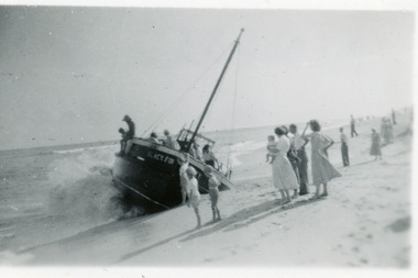
Photograph - Black Fin, c1953
Also black and white enlargement 16 x 25 cmBlack and white photograph showing fishing boat Black Fin aground on Coringle Beach, near Orbost. Picture shows boat on its side, some people onboard and small crowd on beach. Bow of boat facing beach. Lakes Entrance Victoriashipwrecks, coast, ships and shipping -
 Lakes Entrance Historical Society
Photograph - Black Fin, c1953
Also black and white enlargement 16 x 25 cmBlack and white photograph showing fishing boat 'Black Fin' aground at Corringle Beach near Orbost. Picture shows boat broadside to beach with bow facing west. Lakes Entrance Victoriacoast, shipwrecks, ships and shipping -
 Lakes Entrance Historical Society
Photograph - Mouth of Yerang River, Fish M, Cape Conran Victoria, 2000
Also a second colour photograph of Yerang river back from mouth 05120.1 9 x 25 cmColour photograph of mouth of the Yerang River east of Cape Conran Victoriawaterways, coast, rivers -
 Lakes Entrance Historical Society
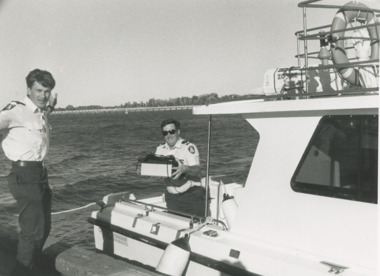
Photograph - Paynesville Water Police, Lakes Post Newspaper, 1/04/1996 12:00:00 AM
Water Police Snr Const. Tony Burke and Snr Const. Brian Hall of Paynesville Water Police docked at Lakes Entrance Victoria. An abandoned EPFRG emergency position indicating Beacon set off the alarm in Canberra initiating a full emergency response with helicopter, water police, coastguard and other units involved. The EPFRG was eventually located in a rubbish bin on a private property in Lakes EntranceBlack and white photograph of two Water Police Snr Const. Tony Burke and Snr Const. Brian Hall of Paynesville Water Police docked at Lakes Entrance Victoriacoast, defence services, police -
 Lakes Entrance Historical Society
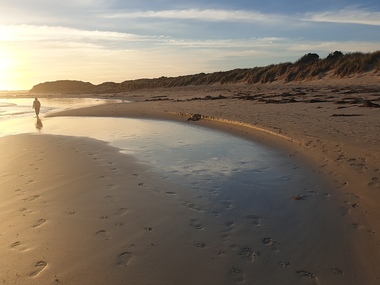
Photograph - Ocean Beach, Lakes Post Newspaper, 1/06/2000 12:00:00 AM
Colour photograph taken from Eastern Beach looking towards the west showing expanse of sand between calm ocean and shrub covered coastal dunes, two people on sand Lakes Entrance Victoriacoast, ocean, waterways -
 Lakes Entrance Historical Society
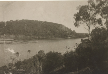
Photograph - Lake Bunga, H D Bulmer, 1910c
Sepia toned photograph showing heavily timbered steep banks on each side of calm water, distant view of timber tramway bridge which appears to be intact Lake Bunga Victoriaocean, vegetation, coast -
 Bendigo Military Museum
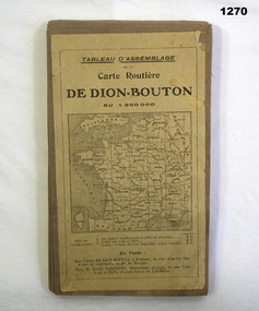
Accessory - MAP, 1914-1919
The map belonged to Jack Grinton No 1043, 38th Batt AIF. Part of the Grinton collection which included hundreds of negatives and developed photos that he took during the War. Refer Cat No 1280 for service details. Refer 1317P, 1320P.Map of a small sector of France. The coloured map is on a grey canvas backing. Map covers an area from the coast to Amiens to St Quentin-north to south from Bethune-Arras-Richecourt. The map has 32 panels and folds down into one."Carte Routiere De Dion Bouton Amiens"docuents-maps-france, military history -
 National Vietnam Veterans Museum (NVVM)
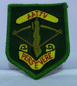
Uniform - Uniform, Army, AATTV Perservere - shoulder patch
Insignia on dark green background with light green edging. AATTV Perservere embroidered in red on yellow background. Olive bar with black outline with brown string. 55th Anniversary National Reunion Gold Coast, Qld 28th-29th July, 2017AATTV perservereaattv, insignia, australian army training team vietnam (aattv)