Showing 493 items matching " county of bendigo"
-
 Bendigo Historical Society Inc.
Map - BENDIGO WEST IRRIGATION SETTLEMENT, 13/02/1909
... of Sandhurst, County of Bendigo. Parish plan. ( number 191 in Map..., County of Bendigo. Parish plan. ( number 191 in Map Cupboard 1 ...Map: Bendigo West Irrigation Settlement, Parish of Sandhurst, County of Bendigo. Parish plan. ( number 191 in Map Cupboard 1)map, bendigo, irrigation settlement, bendigo west irrigatioon settlement -
Bendigo Historical Society Inc.
Map - BENDIGO, October 1st 1893
... Map: Bendigo, Plan of the whole county of Bendigo showing... for selection Map: Bendigo, Plan of the whole county of Bendigo showing ...Map: Bendigo, Plan of the whole county of Bendigo showing areas now available for selection (number 256 in map cupboard 1)map, bendigo, lands available for selection, bendigo, land available for selection -
Bendigo Historical Society Inc.
Map - PARISH OF EGERTON, 19/03/1894
... , County of Bendigo. Parish plan ( number 245 in Map Cupboard 1)..., County of Bendigo. Parish plan ( number 245 in Map Cupboard 1 ...Map: Parish of Egerton, Settlement on Lands Act 1893, County of Bendigo. Parish plan ( number 245 in Map Cupboard 1)map, bendigo, settlement on lands act 1893, egerton, settlement on lands act 1893. -
 Bendigo Historical Society Inc.
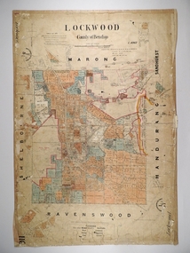
Map - LOCKWOOD, 13/03/1876
... Map: Lockwood, County of Bendigo. Parish plan. Compiled Jan..., County of Bendigo. Parish plan. Compiled Jan. 1876. W. P. Lake ...Map: Lockwood, County of Bendigo. Parish plan. Compiled Jan. 1876. W. P. Lake Draftsman. paper on canvas backing.map, bendigo, parish plan, lockwood, w. p. blake -
 Bendigo Historical Society Inc.
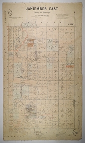
Map - JANIEMBER EAST, 26/07/1879
... Map: Janiember East, County of Bendigo. Parish plan...: Janiember East, County of Bendigo. Parish plan Examined by T Pures ...Map: Janiember East, County of Bendigo. Parish plan Examined by T Pures 16.10.75 S M Reed August 1875map, bendigo, parish plan, janiember east, serpentine -
Bendigo Historical Society Inc.
Map - PARISH OF MARONG, 24/09/1874
... Map; Parish of Marong ,County of Bendigo. This plan has... Bendigo parish plan Marong Map; Parish of Marong ,County ...Map; Parish of Marong ,County of Bendigo. This plan has been cut and then applied to a different backing. ( number 234 in Map Cupboard 1)map, bendigo, parish plan, marong -
Bendigo Historical Society Inc.
Map - COUNTRY LANDS, 4/06/1874
... and Nolan, County of Bendigo. Parish plan (number 298 in map... and Nolan, County of Bendigo. Parish plan (number 298 in map ...Map: Country lands, Parishes of Goornong, Egerton, Elmore and Nolan, County of Bendigo. Parish plan (number 298 in map cupboard 1)map, bendigo, country lands, country lands, goornong, elmore, egerton, nolan -
Bendigo Historical Society Inc.
Map - AVAILABLE ALLOTMENTS, 10/08/1908
... and Egerton, County of Bendigo. Parish plan (coloured) (number 330... and Egerton, County of Bendigo. Parish plan (coloured) (number 330 ...map: Available Allotments, Parishes of Whirrakee, Bagshot and Egerton, County of Bendigo. Parish plan (coloured) (number 330 in map cupboard 1)map, bendigo, allotments, available allotments, whirrakee, bagshot, egerton -
 Bendigo Historical Society Inc.
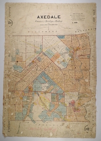
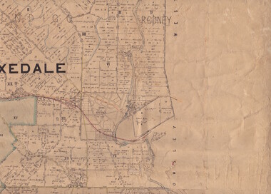
Map - AXEDALE, 26/07/1877
... Map: Axedale, Counties of Bendigo and Rodney. Parish plan...: Axedale, Counties of Bendigo and Rodney. Parish plan Draughtsman E ...Map: Axedale, Counties of Bendigo and Rodney. Parish plan Draughtsman E. Daniell Sept. 1876. Examined by Harvey 1/6/1877map, bendigo, parish plan, axedale, e. daniell, harvey -
 Bendigo Historical Society Inc.
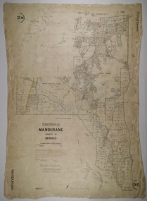
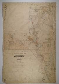
Map - MANDURANG 3, 10/11/1909
... Map: Mandurang, County of Bendigo. Parish plan Examined.... Porter Map: Mandurang, County of Bendigo. Parish plan Examined ...Map: Mandurang, County of Bendigo. Parish plan Examined by W. S. Stephen 11.12.79 W. E. Porter Draughtsman July 1879map, bendigo, parish plan, mandurang, w. s. stephen, w. e. porter -
 Bendigo Historical Society Inc.
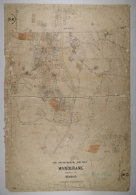
Map - MANDURANG 2, Date unreadable
... Map: Mandurang, County of Bendigo. Parish plan Examined... Map: Mandurang, County of Bendigo. Parish plan Examined by W ...Map: Mandurang, County of Bendigo. Parish plan Examined by W. S. Stephen 11.12.79 W. E. Porter Draughtsman July 1879map, bendigo, parish plan, mandurang, w.s. stephen, w. e. porter -
 Bendigo Historical Society Inc.
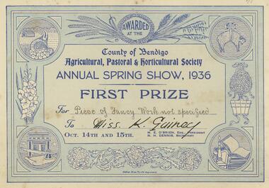
Document - GUINEY COLLECTION: CERTIFICATE, 1936
... . County of Bendigo..... Guiney for Piece of Fancy work, not specified. County of Bendigo ...Document. First Prize Certificate Annual Spring Show 1936 awarded to Miss K. Guiney for Piece of Fancy work, not specified. County of Bendigo.document, certificate, first prize for spring show -
Bendigo Historical Society Inc.
Map - KAMAROOKA STATE FOREST, 23/11/1910
... , Parishes of Neilborough and Whirrakee, County of Bendigo. Parish... of Neilborough and Whirrakee, County of Bendigo. Parish plan (number 287 ...Map: Part of Subdivision of kamarooka State Forest, Parishes of Neilborough and Whirrakee, County of Bendigo. Parish plan (number 287 in map cupboard 1)map, bendigo, subdivision, kamarooka state forest, subdivision, whirrakee -
 Bendigo Historical Society Inc.
Map - MANDURANG 1, Examined 11/12/1879
... Map: Mandurang 2, County of Bendigo. Parish plan Examined.... Porter Map: Mandurang 2, County of Bendigo. Parish plan Examined ...Map: Mandurang 2, County of Bendigo. Parish plan Examined by W. S. Stephen 11.12.79 W. E. Porter Draughtsman July 1879map, bendigo, parish plan, mandurang, w. s. stephen, w. e. porter -
 Bendigo Historical Society Inc.
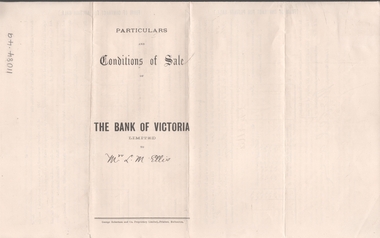
Legal record - ELLIS Edward Woodrow Tregenza - Land sale records, Watson, James & Rogers, Rogers Collection, 1907
... allotments 20, 22, 23 Parish of Sandhurst, County of Bendigo... of subdivision of crown allotments 20, 22, 23 Parish of Sandhurst, County ...In the early 1980s the firm of Watson, James & Rogers merged with the partnership of Every & Every and became the iconic “Rogers & Every” as known today. The firm is still located on Bull Street. https://rogersevery.com.au/about/* Particulars, conditions of sale and contract from bank of Victoria to Louisa Mary Ellis. 1907. * Plan of subdivision of crown allotments 20, 22, 23 Parish of Sandhurst, County of Bendigo * Agreement between Rupert Noyes Putnam of Williamson St. Bendigo and Edward Woodrow Tregenza Ellis of High St Bendigo for Crown allotments 18 and 19, Parish of Sandhurst County of bendigo.Signaturesrupert noyes putnam, land sales -
Bendigo Historical Society Inc.
Map - MANDURANG, 8/10/1887
... Parish of Mandurang, County of Bendigo. Traced from a re... of Mandurang, County of Bendigo. Traced from a re-survey of the Parish ...Parish of Mandurang, County of Bendigo. Traced from a re-survey of the Parish of Mandurang by Mr. Geo. Black 8/10.1887 ( number 158 in Map Cupboard 1)map, bendigo, parish plan, mandurang, re-survey, couny of bendigo -
Bendigo Historical Society Inc.
Map - LEICHARDT, 23/05/1875
... Map: Parish of Leichardt, County of Bendigo. Parish plan... Bendigo building lots Leichardt Map: Parish of Leichardt, County ...Map: Parish of Leichardt, County of Bendigo. Parish plan (coloured). Attached plan in the top left hand corner marked 'Building Lots' (number 323 in map cupboard 1)map, bendigo, building lots, leichardt -
 Bendigo Historical Society Inc.
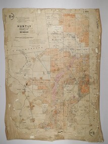
Map - JACK FLYNN COLLECTION: HUNTLY, 12.03.1932
... Map: Township of Huntly, Parish of Huntly , County...: Township of Huntly, Parish of Huntly , County of Bendigo. Parish ...Map: Township of Huntly, Parish of Huntly , County of Bendigo. Parish plan. Western and South Riding Division on Main St. (Main Northern Highway) - written in ink below name of map.BY Authority H.J. Green. Photo-Lithographed at the Dept., of Lands and Survey, Melbourne. 12.3.32map, bendigo, township, huntly -
Bendigo Historical Society Inc.
Map - HUNTLY, SHEET 4, 29/03/1876
... Map: Parish of Huntly, Sheet 4, County of Bendigo. Hand... Bendigo parish plan Huntly Map: Parish of Huntly, Sheet 4, County ...Map: Parish of Huntly, Sheet 4, County of Bendigo. Hand Draughted Parish plan. Originally in Map Cupboard. Relocated to Map Drawer 5 on 22.9.22. Too long for the map cupboard.map, bendigo, parish plan, huntly -
 Bendigo Historical Society Inc.
Map - NEILBOROUGH, 21/01/1875
... Map: Parish of Neilborough, County of Bendigo. Hand... Map: Parish of Neilborough, County of Bendigo. Hand draughted ...Map: Parish of Neilborough, County of Bendigo. Hand draughted Parish plan. Resurveyed by Mr Assistant-Surveyor G Black. Drawn by W A Taylor. Map dated 21/1/1875.map, bendigo, parish plan, neilborough, g. black, w.a. taylor -
 Bendigo Historical Society Inc.
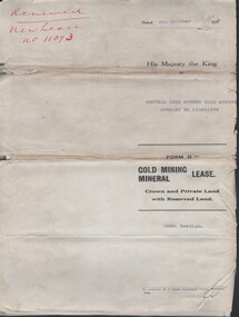
Document - MCCOLL, RANKIN AND STANISTREET COLLECTION: CENTRAL NELL GWYNNE - FORM D GOLD MINING LEASE 10981 BENDIGO, 5 Oct 1936
... of Bendigo Parish of Sandhurst City of Bendigo County of Bendigo... of Bendigo Parish of Sandhurst City of Bendigo County of Bendigo ...Document. Renewal New Lease no 11073 His Majesty the King to Central Nell Gwynne GMC N/L. 1 map no 10981 of Mining District of Bendigo Parish of Sandhurst City of Bendigo County of Bendigo. No 10981 Bendigo Vo 322 Fol 35594.McColl, Rankin & Stanistreetorganization, business, central nell gwynne, mccoll, rankin & stanistreet, cnetral nell gwynne, gold mining, lease -
 Bendigo Historical Society Inc.
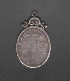
Medal - CONSTABLE JOHN BARRY COLLECTION: JOHN AND THOMAS BARRY
... for their Irish Jaunting Car. Around edge of medal: County of Bendigo... Jaunting Car. Around edge of medal: County of Bendigo Agricultural ...Medal awarded to Barry Brothers at the National Show 1892 for their Irish Jaunting Car. Around edge of medal: County of Bendigo Agricultural and Horticultural Society 1892. On centre: Barry Brothers, Irish Jaunting Car.bendigo, institutions, bendigo agricultural society -
 Bendigo Historical Society Inc.
Map - Parish of Strathfieldsaye
... Shire of Strathfieldsaye County of Bendigo canvas backed... Eppalock Shire of Strathfieldsaye County of Bendigo canvas backed ...Map owned by Henry Thomas (Jack) Qualtrough who worked for the Victorian Forestry Commission. Shire of Strathfieldsaye County of Bendigo canvas backed map. L5169. Includes Axedale, Kimbolton, Eppalock and Sedgewick. Photographed/Lithographed for the Department of Lands and Survey Melbourne by T E McGauran 24.3.07. Price 1/-.map, axedale, kimbolton, sedgewick, eppalock -
 Bendigo Historical Society Inc.
Map - HUNTLY, 16/11/1903
... Map: Huntly, County of Bendigo. Parish plan. Drawn... Walshe H Hansford Huntly Map: Huntly, County of Bendigo. Parish ...Map: Huntly, County of Bendigo. Parish plan. Drawn by Bartholomew Becket, examined by W S Stephen 15/3/80, examined by J Walshe Sept 1903, additions H Hansford August 1903map, bendigo, parish plan, bartholomew becket, w s stephen, j walshe, h hansford, huntly -
 Bendigo Historical Society Inc.
Map - CAMPBELL COLLECTION: BENDIGO AND DISTRICT MAPS, 1959
... Map. Huntly, County of Bendigo, Neilborough, Bagshot... Printer Map. Huntly, County of Bendigo, Neilborough, Bagshot ...Map. Huntly, County of Bendigo, Neilborough, Bagshot, Nerring, Wellsford, Sandhurst. Township of Huntly. By Authority A.C. Brooks, Government Printer Melbourne. Drawn and reproduced at the Department of Lands and Survey, Melbourne, 1958. Price 5/-.A.C. Brooks, Government Printermap, bendigo, allotments, huntly -
 Bendigo Historical Society Inc.
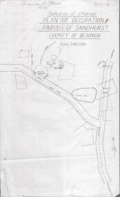
Photograph - DIAMOND HILL 1936, PLAN OF OCCUPATION
... parish of Sandhurst, County of Bendigo' Plan shows Post Office..., plan of occupation parish of Sandhurst, County of Bendigo' Plan ...Print of 'Application of J. Hattam, plan of occupation parish of Sandhurst, County of Bendigo' Plan shows Post Office site, large dam, 'formerly cultivated site near Post Office'. A un-named gully is marked.bendigo, mining, diamond hill -
Bendigo Historical Society Inc.
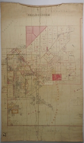
Map - BENDIGO (COUNTY), Circa 1870's
... BENDIGO (COUNTY)...Map:Plan showing the whole of the County of Bendigo... the whole of the County of Bendigo-- attached handwritten sheet ...Map:Plan showing the whole of the County of Bendigo-- attached handwritten sheet in the top left hand corner-'Proclaimed Commons Sandhurst District'. Also attached is a separate plan of the parish of Kimbolton (number 262 in map cupboard 1)map, bendigo, parish plan, bendigo, proclaimed commons -
Bendigo Historical Society Inc.
Map - CAMPBELL COLLECTION: BENDIGO AND DISTRICT MAPS, 11-2-37
... Map. Parish of Shelbourne, County of Bendigo. Scale 40.... Parish of Shelbourne, County of Bendigo. Scale 40 chains to 1 ...Map. Parish of Shelbourne, County of Bendigo. Scale 40 chains to 1 inch. Drawn and reproduced at the Department of Lands and Survey, Melbourne, Victoria. Price 2/-.11-2-37. By Authority H.J. Green, Government Printer, Melbourne.H.J. Green, Government Printermap, bendigo, agricultural lands -
 Bendigo Historical Society Inc.
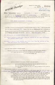
Legal record - BERRY Harold Rupert Daniel - Covenant and Indemnity, Watson, James & Rogers, Rogers Collection, 1930
... , Section H, City of Bendigo Parish of Sandhurst, County of Bendigo... Parish of Sandhurst, County of Bendigo. Dated 17 April 1930 ...In the early 1980s the firm of Watson, James & Rogers merged with the partnership of Every & Every and became the iconic “Rogers & Every” as known today. The firm is still located on Bull Street. https://rogersevery.com.au/about/Covenant and Indemnity from Mrs A G and Mr M McKenzie to Harold Rupert Daniel Berry concerning Crown Allotment 392, Section H, City of Bendigo Parish of Sandhurst, County of Bendigo. Dated 17 April 1930.Signatureswatson james & rogers, bendigo, legal documents, covenant -
 Bendigo Historical Society Inc.
Document - MCCOLL, RANKIN AND STANISTREET COLLECTION: GOLD MINING LEASE CROWN LAND, 1937
... , includes map County of Bendigo, Parish of Mandurang. Dated 1937... 10916 Bendigo. Foolscap size document, includes map County ...Document : McColl, Rankin and Stanistreet: gold mining lease crown land 10916 Bendigo. Foolscap size document, includes map County of Bendigo, Parish of Mandurang. Dated 1937 between King George VI and John Jepson Stanistreet.person, mining, john jepson stanistreet, mccoll, rankin and stanistreet: bendigo, mining, goldmining, john stanistreet