Showing 963 items
matching dams
-
 Wonga Park Community Cottage History Group
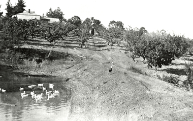
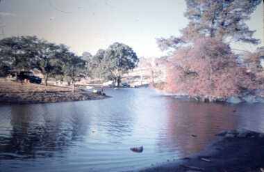
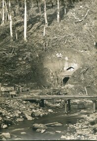
Photograph (Item) - Black and White, Wonga Park: Read's Dam, Orchard and House, c. 1931
Wonga Park: Read's Dam, Orchard and HousePhoto is named 14880016.jpg on CD -
 Glenelg Shire Council Cultural Collection
Photograph - Photograph - Thomas Borthwick and Sons, n.d
Port of Portland Authority Archivesport of portland -
 Kiewa Valley Historical Society
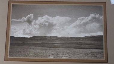
Photo - Pretty Valley, Bogong High Plains
Pretty Valley, Bogong High Plains is part of the Kiewa Hydro Electric SchemeBogong High Plains prior to the construction of the Kiewa Hydro Electric SchemeLarge rectangular sepia photo mounted on thick cardboard which has a printed frame around the photo. The photo is of Pretty Valley prior to the construction of the dam.On the back: 'Pretty Valley, Bogong High Plains'; Also: 'No 20' and '2389'pretty valley, pretty valley bogong high plains -
 Federation University Historical Collection
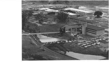
Photograph - Photograph, Black and White, Ballarat Institute of Advanced Education Mount Helen Campus, 1974, 1974
Aerial view of Ballarat Institute of Advanced Education Mount Helen Campus. It shows the oval and two dams in close proximity to the E.J. Barker Library. 1974ballarat institute of advanced education, library, mt helen, aerial, mount helen campus, e.j. barker library, mount helen library -
 Bendigo Historical Society Inc.
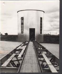
Photograph - MICHELSEN COLLECTION: WATER TOWER
Photograph, Water Tower, under construction, worker near door opening. Houses at right background possibly workers huts, could be at the construction of Eppalock Dam. -
 Bendigo Historical Society Inc.
Slide - DAVID MCDONALD COLLECTION: EPPALOCK. CONSTRUCTION, c1963
Eppalock. Construction. Lake Eppalock appears to already have become a popular spot for camping and fishing. Markings: Eppalock Dam near Lyal, March 1963.Kodakcivil engineering, water supply, eppalock -
Tatura Irrigation & Wartime Camps Museum
Photograph, May, 1888
Taken by photographer for State Rivers and Water Supply Commission.Medium sized black and white photograph. Wooden trestles across river - coffer dams on left fallen timber foreground lying in water of the river bed.goulburn weir, victorian state rivers and supply commission -
Tatura Irrigation & Wartime Camps Museum
Book, Centenary Committee Mooroopna NW Primary School et al, Mooroopna North West (Ram Dam), 1978
Published in association with Centenary Celebrations of Mooroopna North West Primary School 1978Brown cardboard cover. Oval photo - water scene. Illustrated. 36 pages, Mooroopna North West (Ram Dam) No 2002 1878 1978 on scroll.To Tatura Historical Society with my compliments. M J. Delaney, Tatura Irrigation and Local History Museummooroopna north west primary school, school centenary celebrations -
 Wodonga & District Historical Society Inc
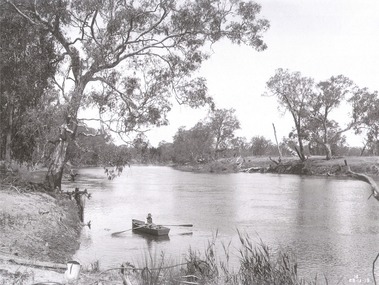
Album - Hume Reservoir Australia Album - The River Murray at the site of the dam 28th November, 1919
This set of photos is from a leather bound album bearing the inscription "HUME RESERVOIR AUSTRALIA" plus 'The Rt. Hon. L. C. M. S. Amery, P. C., M .P.' all inscribed in gold. It was presented to The Rt. Hon. L. C. M. S. Amery, P. C., M. P, Secretary of State for Dominion Affairs on the occasion of his visit to the Hume Reservoir on 2nd November 1927. This album is of local and national significance as it documents the planning and development of the Hume Reservoir up to 1927. It was the largest water reservoir in the British Empire. The album records the pioneering engineering work that went into its construction.DEPARTMENT OF PUBLIC WORKS, N.S.W. RIVER MURRAY WATERS SCHEME. HUME RESERVOIR. The River Murray at the site of the dam on 28th November 1919 looking upstream. hume reservoir australia, river murray waters scheme, hume weir diagrams, hume plan details -
 Lakes Entrance Historical Society
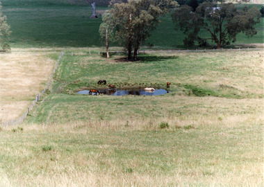
Photograph, Tambo Shire, 1994 c
Also second identical copyColour photograph of a rural view near Buchan, shows five horses in and around a dam, farming building in distance glimpsed through trees. Bruthen Victoria topography, agriculture -
 Federation University Historical Collection
Photograph, Colour, Clare Gervasoni, Creek that flows through Federation University Mount Helen Campus, 2015, 22/04/2015
The headwaters of Canadian Creek are located in Mt Helen as a series of springs in the vicinity of Gear Avenue. The dam to the north of Gear Avenue was expanded as part of the development of the Information Technology Centre. Recent works have added a large wetland below the dam. Further dams are located on drainage lines within the University of Ballarat grounds. Five photographs showing the creek that flows through Federation University Mount Helen campus after a 'clean up' to remove blackberry and other weeds. The photographs were taken from near the swimming pool. After clean up works on the Creek that flows through Federation University Mount Helen Campus, 2015mount helen, mount helen campus, canadian creek catchment -
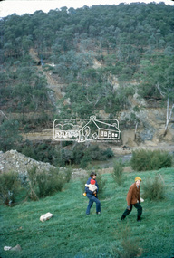 Eltham District Historical Society Inc
Slide, Site of proposed Yarra Brae Dam, Jul. 1973
With an increasing need to grow Melbourne's water supply, in 1973, the State Government announced plans for the development of Sugarloaf Reservoir. Two dams were to be built, one across the Yarra from the Yarra Brae property in Wonga Park to the Bend of Isles. Water was to be pumped from this dam to the higher level Sugarloaf Reservoir. The proposed extensive flooding of large numbers of properties resulted in significant community backlash and ultimately abandonement of the proposed Yarra Brae dam.35 mm colour positive transparency (x 3) Mount - Kodak Kodachrome Cardyarra brae dam -
 Kiewa Valley Historical Society
Postcard - Junction Dam - Circa 1950, Circa 1950's
This postcard was produced in the 1950's for the tourist trade in the Kiewa Valley and Alpine region. It encompasses the period when the State of Victoria was pressured by the ever increasing demand by industry and its population for electricity supplies. Hydro electricity was seen as an untapped natural resource to quench this demand. The Victorian Alps and the rivers flowing into its valleys was ideal for the construction of the Kiewa Hydro Electricity Scheme. The late 1940's saw the development of this scheme and the changing of sections of alpine landscape is covered by this and other postcards/pictures (tourists, construction workers, and established rural populations). This period in time was before the established wildlife and forest/nature groups became political activist who changed legislative acts to protect the environment.This rural region (Kiewa Valley/alpine plains) was at most only significant to a smaller group of winter sports, summer hikers/horse riders and rural farmers/graziers. The numbers of tourists and the increase in the local resident population was boosted by the construction of the Hydro Electricity Scheme. This influx to the regional population resulted in a corresponding diversity in services and brought about an environment that responded to a growing level of tourists and thereby permitting this industry to grow more rapidly than it would have naturally. This postcard details an attraction to the "cleaner" method of providing electricity. This postcard was purchased in 1950 by a surveyor at Landford's Gap.This black and white photograph is a Valentine's postcard, from a V2 Argus photograph. It is on a 200g/m paper density with only the photo side gloss.Front "JUNCTION DAM & SPILLWAY, BOGONG KIEWA HYDRO-ELECTRIC PROJECT" on the flip side "VALENTINE'S POST CARD " "A GENUINE PHOTOGRAPH"kiewa valley tourism, victorian alps, alternate energy supplies, alpine population growth, junction dam, secv -
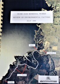 Wodonga & District Historical Society Inc
Booklet - Hume Dam Remedial Works - Review of Environmental Factors July 1995, Department of Land and Water Conservation, NSW Government, July 1995
The findings of a review into the environmental impact of remedial works being carried out on the Hume Dam.non-fictionThe findings of a review into the environmental impact of remedial works being carried out on the Hume Dam.hume dam, remedial works dams, environmental impact of dams -
 Greensborough Historical Society
Photograph - Digital image, Bucks Dam 2009, 02/08/2009
Photograph of Bucks Dam in Greensborough. This was a popular swimming hole in the past.Digital copy of colour photograph.bucks dam -
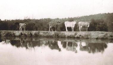 Greensborough Historical Society
Photograph - Digital image, Cows on Hill Dam at Apollo Parkways, 1935c
Dam on the Partington property at what is now Apollo Parkways Greensborough.The Partington family came to Melbourne in the 1840s and moved to Greensborough where they farmed along the Plenty River. Descendants still live in Greensborough.Digital copy of black and white photograph.partington family -
 Halls Gap & Grampians Historical Society
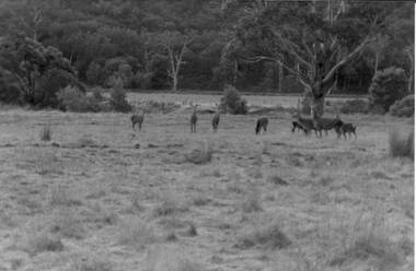
Photograph - Coloured, C 1980s
Photo is located on Fyans Valley floor below Bellfield dam,Photo is of nine deer in a grassy paddock with bushland at the rear. A large gumtree stands middle foreground. A dead gumtree stands in the background,Fujicolor papernatural history, feral animals -
Stawell Historical Society Inc
Map - Subdivision map, Subdivision of North Woodlands Estate Map
Shows Homestead Cottage and Dam, Plus Shed. Malakoff NavarreA3 photocopy of MapParishes of Malakoff and Navarre. County of Kara karasurvey -
 Marysville & District Historical Society
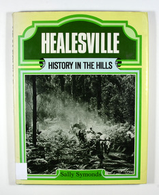
Book, Healesville-History in the Hills, 1982
A history of HealesvilleHardcover. Front cover of dust jacket has a photograph of a bullock team hauling a load of timber. Back cover of dust jacket has a photograph of the Maroondah Dam.Stamp of the Marysville & District Historical Society Inc / P.O. Box 22 / Marysville 3779 R. Whitford For/ MANDY/ whose love of the bush/ brought us to Healesvillehealesville, upper yarra valley, victoria, australia, sally symonds, history -
 Federation University Historical Collection
Photograph - Photograph - Colour, University of Ballarat Vice-Chancellor Professor Kerry Cox, 2001, 2001
Professor Kerry Cox was Vice Chancellor of the University of Ballarat from 01 January 2001.Digital image of Professor Kerry Cox standing in high grass in front of a body of water. The water is probably the dam near the swimming pool at Mount Helen Campusuniversity of ballarat, kerry cox, cox, vice-chancellor, mount helen -
 Bendigo Historical Society Inc.
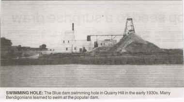
Newspaper - JENNY FOLEY COLLECTION: SWIMMING HOLE
Bendigo Advertiser "The way we were" from Thursday, March 31, 2005. Swimming hole: the blue dam swimming hole in Quarry Hill in the early 1930snewspaper, bendigo advertiser, the way we were -
 Bendigo Historical Society Inc.
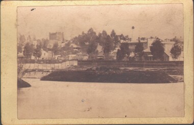
Photograph - WES HARRY COLLECTION: UPPER RESERVE DAM/KNIPES CASTLE, 1870's
Photograph depicting the Upper Reserve Dam with an island. Barnard St. is behind a picket fence in the middle distance and Knipes Castle is on the skyline, left hand side of the photo.place, bendigo, knipes castle, upper reserve dam, barnard st, knipes castle -
Tatura Irrigation & Wartime Camps Museum
Photograph, Eildon Reservoir, 1955
Taken by photographer for State Rivers and Water Supply Commission.Large sepia photograph Eildon Reservoir - cars buses and people on road, top of dam wall - motor launch mid-photo, rounded hills forming horizonvictorian state rivers and supply commission, eildon reservoir -
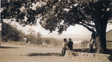 Mt Dandenong & District Historical Society Inc.
Photograph, FiveWays, Kalorama Looking Towards Silvan Dam, c1930
Close up of elm tree at FiveWays with a man and woman seated on stone bank and a man standing under the tree. Silvan Dam visible in distance. (2 copies)fiveways, kalorama, silvan dam -
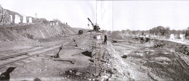 Wodonga & District Historical Society Inc
Album - Hume Reservoir Australia Album - Excavations for foundations of spillway, September 1921
This set of photos is from a leather bound album bearing the inscription "HUME RESERVOIR AUSTRALIA" plus 'The Rt. Hon. L. C. M. S. Amery, P. C., M .P.' all inscribed in gold. It was presented to The Rt. Hon. L. C. M. S. Amery, P. C., M. P, Secretary of State for Dominion Affairs on the occasion of his visit to the Hume Reservoir on 2nd November 1927. This album is of local and national significance as it documents the planning and development of the Hume Reservoir up to 1927. It was the largest water reservoir in the British Empire. The album records the pioneering engineering work that went into its construction.DEPARTMENT OF PUBLIC WORKS, N.S.W. RIVER MURRAY WATERS SCHEME. HUME RESERVOIR. 6. Excavation in progress for foundations of outlet and spillway sections of dam. September 1921.hume reservoir australia, river murray waters scheme, hume weir diagrams, hume plan details -
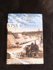 Stawell Historical Society Inc
Book, Rhona van Veldhuisen, Pipe Dreams, A stroll through the history of water supply in the Wimmera Mallee, 2001
A History of Domestic and Stock Water supply in the Wimmera Mallee from 1836 to 1997Blue Hard Cover with Gold Print. Dust Jacket. Blue sky with clouds above b/W/ dam wall under construction, steam Train in foregound Pipe dreams A stroll through the history of water supply in the Wimmera Mallee. By Rhonda van Veldhuisen based on records researched by Bob McIIvenastawell water supply -
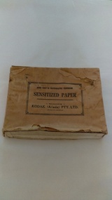 Kiewa Valley Historical Society
Photographs of small box originally used to contain sensitized photographic paper
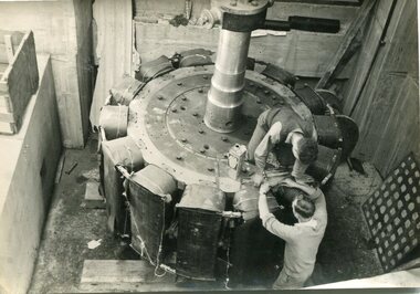
The Junction Dam and Clover Dam Power Station, stages of the Kiewa Hydro-Electric Scheme, were needed to meet the increased power demands of the wartime industry in Victoria. Clover added 26 megawatts to the grid. Junction Dam was completed and ready to hold water by September 1943, but was emptied in December 1943 and not filled again until May 1944. Construction of Clover Power Station commenced in July 1941 and both turbines were in service by May 1945.Clover Power Station and Junction Dam were part of the Kiewa Hydro Electric Scheme constructed by the State Electricity Commission of Victoria. SECV official photographers took photographs of most stages of construction of the Hydro Electric Scheme and referenced each photo with a number and dating system as an historical record and for reference for other projects. This provided a thorough history of the construction of the Hydro Electric Scheme, some of the workers involved in its construction and the infrastructure supporting its construction, such a Bogong Village.Small light brown cardboard box originally containing sensitized photographic paper, now containing a range of black and white photographs of the Kiewa Hydro Electric System taken by the official SECV photographer Box has some damage – Front panel on lid is missing. Top has a puncture in top right corner and some peeling of paper along sides and at edges. Printed on the top of the box in black ink: OPEN ONLY IN PHOTOGRAPHIC DARK ROOM SENSITIZED PAPER Manufactured by – KODAK (A/asia) PTY. LTD. Melbourne Australia Green and white sticker on right side of lid and bottom right side of box, torn at join 1. 1B1 Single Weight Soft. Available in Soft (1) Medium (2) Contrast (3) Extra Contrast (4) Single and Double Weight Stamped at bottom of sticker in grey ink G8087 CK photographic paper box; state electricity commission of victoria; official photographer; kiewa hydro electric scheme; clover power station; junction dam; bogong village -
 Kiewa Valley Historical Society
Photographs – SECV – Clover Power Station
The Junction Dam and Clover Dam Power Station, stages of the Kiewa Hydro-Electric Scheme, were needed to meet the increased power demands of the wartime industry in Victoria. Clover added 26 megawatts to the grid. Junction Dam was completed and ready to hold water by September 1943, but was emptied in December 1943 and not filled again until May 1944. Construction of Clover Power Station commenced in July 1941 and both turbines were in service by May 1945.Clover Power Station and Junction Dam were part of the Kiewa Hydro Electric Scheme constructed by the State Electricity Commission of Victoria.Set of 22 black and white photographs taken by the official SECV photographer who gave each photo a number prefixed by K (for Kiewa) K60 -no date- A bridge and entrance to tunnel K519 -no date- Welding steel lining in the tunnel K531 –no date- Construction on the Kiewa Scheme (tunnel in background K821 – no date- Bogong Village, early days K928 -15 Oct 1942- Construction Clover Power Station K947 -26 Oct 1942- Construction Clover Power Station K948 -26 Oct 1942- Construction Clover Power Station K949- 26 Oct 1942- Clover Camp in background K950 -26 Oct 1942- Construction Clover Power Station K955 -27 Oct 1942- Constructing the bridge at Clover K1102 -7 April 1943- Inlet pipe to power station K1179 –no date- Clover Power Station K1187 – no date- Clover Power Station K1189 -24 June 1943- Part of the spiral casing 1199 -7 July 1943- Clover Power Station K1201 -7 July 1943- Clover Power Station K1231 -26 July 1943- Gantry crane for Clover Power Station K1308 -6 Sept 1943- Spiral casing K1334 -6 Oct 1943- Lake Guy. Bogong Village in background K1342 -29 Oct 1943- Power station under construction K1365 -19 Nov 1943- Power station under construction K1366 -19 Nov 1943- Gantry crane for Clover Power Station On the back- each photograph has a handwritten reference number starting with K and the date stamped or written (see above)secv; kiewa hydro electric scheme; official photographer; junction dam; clover power station; bogong; -
 Kiewa Valley Historical Society
Photographs – SECV – Clover Power Station
The Junction Dam and Clover Dam Power Station, stages of the Kiewa Hydro-Electric Scheme, were needed to meet the increased power demands of the wartime industry in Victoria. Clover added 26 megawatts to the grid. Junction Dam was completed and ready to hold water by September 1943, but was emptied in December 1943 and not filled again until May 1944. Construction of Clover Power Station commenced in July 1941 and both turbines were in service by May 1945.Clover Power Station and Junction Dam were part of the Kiewa Hydro Electric Scheme constructed by the State Electricity Commission of Victoria.Set of 21 black and white photographs taken by the official SECV photographer who gave each photo a number prefixed by K (for Kiewa) K1367- 19 Nov 1943 The rotor for the generator K1368- 19 Nov 1943 Base of the generator K1377- 2 Dec 1943 Generator under construction K1380- 2 Dec 1943 Power Station under construction K1381- 2 Dec 1943 Generator being assembled K1386- 3 Dec 1943 Part of the generator K1389- 30 Dec 1943 Inlet pipe work K1391- 30 Dec 1943 Inside the power station K1392- 30 Dec 1943 Inlet pipe work K1396- 27 Jan 1944 Equipment in the power station K1410- 4 FGeb 1944 Unpacking equipment for the power station K1422- 16 Feb 1944 Generator being assembled K1425- 22 Feb 1944 Water way – power station K1433- no date Generator being assembled K1434- 3 Mar 1944 Constr5ucting the power station K1448- no date Generator inside the power station K1450- 17 Mar 1944 Clover Power station K1452- 17 Mar 1944 Looking down on the valve-water release from the power station K1456- 22 Mar 1944 ‘half Travel Opening- No 1 Relief Valve’ Overflow from the power station K1458- 22 Mar 1944 Outlet from the power station K1462- 22 Mar 1944 Inside the power station On the back- each photograph has a handwritten reference number starting with K and the date stamped or writtensecv; kiewa hydro electric scheme; clover power station; junction dam; bogong -
 Kiewa Valley Historical Society
Photographs – SECV – Clover Power Station
The Junction Dam and Clover Dam Power Station, stages of the Kiewa Hydro-Electric Scheme, were needed to meet the increased power demands of the wartime industry in Victoria. Clover added 26 megawatts to the grid. Junction Dam was completed and ready to hold water by September 1943, but was emptied in December 1943 and not filled again until May 1944. Construction of Clover Power Station commenced in July 1941 and both turbines were in service by May 1945Clover Power Station and Junction Dam were part of the Kiewa Hydro Electric Scheme constructed by the State Electricity Commission of VictoriaSet of 21 black and white photographs taken by the official SECV photographer who gave each photo a number prefixed by K (for Kiewa) K1463- 22 Mar 1944 Inside Clover Power Station K1464- 23 Mar 1944 Valve K1466- 23 Mar 1944 Fittings for the power station K1467- 23 Mar 1944 Valve K1472- 30 Mar 1944 Equipment being installed in Clover Power Station K1474- 31 Mar 1944 Equipment for the power station K1493- 19 April 1944 Transformer K1495- 28 April 1944 Part of the generator being installed K1514- 11 May 1944 Equipment in the power station K1563- 9 June 1944 Turbine under construction K1565- 22 June 1944 Shaft between turbine and generator K1567- 22 June 1944 Turbine in the power station K1568- 22 June 1944 Transformers K1570- 5 June 1944 Guide vane actuators K1574- 22 June 1944 Equipment in the power station K1567- 22 June 1944 Clover Power Station K1607- 14 Aug 1944 Equipment in the power station K1620- 27 Aug 1944 ‘Charles Tavare (?) Equipment in the power station K1626- 23 Aug 1944 Clover Power Station K1628- 23 Aug 1944 Clover Power Station K1629- 23 Aug 1944 Clover Power Station On the back- each photograph has a handwritten reference number starting with K and the date stamped or writtensecv; kiewa hydro electric scheme; clover power station; junction dam; bogong