Showing 416 items
matching east burwood
-
 Whitehorse Historical Society Inc.
Article, Know your city, 197-?
... Burwood East Primary School No. 454... Schwerkolt Cottage Slater William Burwood East Primary School No. 454 ...Places of interest in Nunawading. Describes early pioneers and properties in the area.Places of interest in Nunawading. Describes early pioneers and properties in the area.Places of interest in Nunawading. Describes early pioneers and properties in the area.antonio park mitcham, city of nunawading, schwerkolt cottage, slater, william, burwood east primary school no. 454, mcclelland, john, witt, william, tally ho boys home, stanley works pty ltd -
Whitehorse Historical Society Inc.
Article, New bid for cinema, 2005
... Burwood East... Mitcham melbourne Middleborough Road Burwood East Reading ...Article on development plans for former quarry site on Middleborough Road for a cinema complex and discount department store.Article on development plans for former quarry site on Middleborough Road for a cinema complex and discount department store.Article on development plans for former quarry site on Middleborough Road for a cinema complex and discount department store.middleborough road, burwood east, reading entertainment australia pty ltd, burwood heights, commercial development, land subdivision -
 Whitehorse Historical Society Inc.
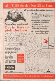
Newspaper - Article, Tally Ho Greens, 17/11/1993
... burwood east..., 28-11-1993. auctions springvale road burwood east highbury ...Advertisement in the Post for auction of 81 home sites on the Tally Ho Estate.Advertisement in the Post for auction of 81 home sites on the Tally Ho Estate bordered by Springvale Road and Highbury Road, 28-11-1993.Advertisement in the Post for auction of 81 home sites on the Tally Ho Estate. auctions, springvale road, burwood east, highbury road, robinson drive, hoadley crescent, betts way, trainor place, sutton court, cole close, mcclelland way, kennard place, vision drive -
Whitehorse Historical Society Inc.
Map, Today's map of Mitcham, Nunawading, Blackburn, 1957
... Burwood East... Mitcham melbourne Maps Mitcham Nunawading Blackburn Burwood East ...Folded detailed map of Mitcham, Nunawading, BlackburnFolded detailed map of Mitcham, Nunawading, BlackburnFolded detailed map of Mitcham, Nunawading, Blackburnmaps, mitcham, nunawading, blackburn, burwood east, forest hill, vermont -
Whitehorse Historical Society Inc.
Map, Parks and recreation facilities, 1/06/1995 12:00:00 AM
... burwood east... south burwood east forest hill mitcham nunawading vermont ...Map of the City of Whitehorse with parks and reserves marked and indexedMap of the City of Whitehorse with parks and reserves marked and indexed.Map of the City of Whitehorse with parks and reserves marked and indexedcity of whitehorse, parks and reserves, bicycle paths, recreation facilities, blackburn, blackburn north, blackburn south, burwood east, forest hill, mitcham, nunawading, vermont, vermont south -
Whitehorse Historical Society Inc.
Map, City of Whitehorse, 1/03/1995 12:00:00 AM
... burwood east... vermont vermont south blackburn north forest hill burwood east ...Map of City of Whitehorse prepared by Richard Meloni showing roads, railways, creeks.Map of City of Whitehorse prepared by Richard Meloni showing roads, railways, creeks.Map of City of Whitehorse prepared by Richard Meloni showing roads, railways, creeks.blackburn, nunawading, blackburn south, mitcham, vermont, vermont south, blackburn north, forest hill, burwood east, city of whitehorse -
Whitehorse Historical Society Inc.
Map, Heritage overlay map, 1/02/1999 12:00:00 AM
... burwood east... vermont vermont south burwood east City of Whitehorse heritage ...City of Whitehorse heritage review : Heritage overlay map.City of Whitehorse heritage review : Heritage overlay map.City of Whitehorse heritage review : Heritage overlay map.city of whitehorse, historic buildings, blackburn, blackburn south, blackburn north, mitcham, nunawading, forest hill, vermont, vermont south, burwood east -
Whitehorse Historical Society Inc.
Map, Shire of Blackburn and Mitcham, 1938
... burwood east... blackburn north blackburn south burwood east forest hill mitcham ...Plan of Shire of Blackburn and Mitcham showing sections and lot numbers. Scale 8 chains to 1 inch.Plan of Shire of Blackburn and Mitcham showing sections and lot numbers. Scale 8 chains to 1 inch.Plan of Shire of Blackburn and Mitcham showing sections and lot numbers. Scale 8 chains to 1 inch.shire of blackburn and mitcham, blackburn, blackburn north, blackburn south, burwood east, forest hill, mitcham, nunawading, vermont, vermont south -
Whitehorse Historical Society Inc.
Map, Shire of Blackburn and Mitcham, c1935
... burwood east... blackburn north blackburn south burwood east forest hill mitcham ...Map of Shire of Blackburn and Mitcham showing refuse collection days, sections and lot numbers. Scale 8 chains to 1 inch.Map of Shire of Blackburn and Mitcham showing refuse collection days, sections and lot numbers. Scale 8 chains to 1 inch.Map of Shire of Blackburn and Mitcham showing refuse collection days, sections and lot numbers. Scale 8 chains to 1 inch.shire of blackburn and mitcham, blackburn, blackburn north, blackburn south, burwood east, forest hill, mitcham, nunawading, vermont, vermont south -
Whitehorse Historical Society Inc.
Map, Aerial maps, 2/04/1966 12:00:00 AM
... burwood east... forest hill nunawading box hill burwood burwood east donvale ...Melbourne 1966 project, runs 10A and 11A, lens 122 151.75 mm 9,800. Photo nos 77, 107, 109, 161, 163, 165.Melbourne 1966 project, runs 10A and 11A, lens 122 151.75 mm 9,800. Photo nos 77, 107, 109, 161, 163, 165. Areas and boundaries: Map no 77 W. Park and Cook Roads; E. Dubon Rd; N Oban Rd; S Reilly St. Map No 107. W. Indra Rd and Pakenham St; E. Rooks Rd & McLares Rd; N. Maroondah Hwy; S. Hawthorn Rd & Eley Rd. Map No 109 W. Elgar Rd. E. Blackburn Rd & McKean St; S. Eley Rd & Burwood Hwy. Map No 161. W. Elgar Rd & Huntingdale Rd; E. Blackburn Rd; N. Burwood Hwy; S. Waverley Rd. Map No 163. W. Blackburn Rd; S. Springvale Rd; N. Eley Rd & Hawthorn Rd; S. Glen Waverley Railway Line. Map No 165. W. Stanley Rd, Vermont South; E. Cathies Lane, Wantirna South; N. North of Burwood Hwy; S. High Street. Melbourne 1966 project, runs 10A and 11A, lens 122 151.75 mm 9,800. Photo nos 77, 107, 109, 161, 163, 165. aerial photographs, blackburn, blackburn south, forest hill, nunawading, box hill, burwood, burwood east, donvale, mount waverley, glen waverley, wantirna, vermont south, mitcham, ringwood north, ringwood -
Whitehorse Historical Society Inc.
Map, City of Nunawading, 1/02/1973 12:00:00 AM
... burwood east... burwood east forest hill mitcham nunawading vermont vermont south ...Map of City of Nunawading shoeing open creeks or watercourses and watercourses that have been piped.Map of City of Nunawading shoeing open creeks or watercourses and watercourses that have been piped. Scale: 800 feet =1 inchMap of City of Nunawading shoeing open creeks or watercourses and watercourses that have been piped. blackburn, blackburn north, blackburn south, burwood east, forest hill, mitcham, nunawading, vermont, vermont south, city of nunawading, creeks -
Whitehorse Historical Society Inc.
Map, Shire of Blackburn and Mitcham, 10/10/1939 update
... burwood east... burwood east forest hill mitcham nunawading vermont vermont south ...Map of Shire of Blackburn and Mitcham showing Departmental ball hydrants and departmental pillar ball hydrants.Map of Shire of Blackburn and Mitcham showing Departmental ball hydrants and departmental pillar ball hydrants. Scale 8 chains to 1 inch.Map of Shire of Blackburn and Mitcham showing Departmental ball hydrants and departmental pillar ball hydrants.shire of blackburn and mitcham, fire hydrants, blackburn, blackburn north, blackburn south, burwood east, forest hill, mitcham, nunawading, vermont, vermont south -
Whitehorse Historical Society Inc.
Article, Last days - schools close down
... Burwood East... proposals. Primary Schools Narmara Primary School Burwood East ...Last days - schools close down,Last days - schools close down, by Wendy Woods. Narmara Primary School and Blackburn Secondary College close. With photo of Narmara students. Discusses history of Blackburn Secondary College and amalgamation proposals.Last days - schools close down, primary schools, narmara primary school, burwood east, blackburn secondary college, secondary schools, blackburn technical school, mullauna secondary college -
Whitehorse Historical Society Inc.
Book, Nunawading - stories of a city, 1/06/1994 12:00:00 AM
... burwood east state school no 454... dairy blackburn returned services league. burwood east state ...A local history project compiled by Keith Rooney containing oral and written historiesA local history project compiled by Keith Rooney containing oral and written historiesA local history project compiled by Keith Rooney containing oral and written historiesrooney, keith, de stoop, roger, dobson, doris, munt, james, vitclay pipes pty ltd, watts, don, tucker, ross, blackburn dairy, blackburn returned services league., burwood east state school no 454, nunawading primary school no. 4190, nunawading, blackburn -
Whitehorse Historical Society Inc.
Document, Scrapbooks, 1963 - 1990
... burwood east... blackburn vermont burwood east forest hill Books of newspaper ...Books of newspaper cuttings compiled for the Nunawading Historical Society 1963 - 1990.Books of newspaper cuttings compiled for the Nunawading Historical Society 1963 - 1990.Books of newspaper cuttings compiled for the Nunawading Historical Society 1963 - 1990.nunawading historical society, nunawading, mitcham, blackburn, vermont, burwood east, forest hill -
Whitehorse Historical Society Inc.
Document, Moorhouse Papers
... burwood east... blackburn vermont burwood east mitcham forest hill Unpublished ...Unpublished manuscript on history of the district of Nunawading 1857 - 1945. With index to Moorhouse Papers held by Nunawading City CouncilUnpublished manuscript on history of the district of Nunawading 1857 - 1945. With index to Moorhouse Papers held by Nunawading City CouncilUnpublished manuscript on history of the district of Nunawading 1857 - 1945. With index to Moorhouse Papers held by Nunawading City Councilmoorhouse, denice, city of nunawading, nunawading, blackburn, vermont, burwood east, mitcham, forest hill -
Whitehorse Historical Society Inc.
Map, Plan of the Parish of Nunawading, 1853
... Burwood East... Burwood East Maps Photocopy of map showing names of selectors ...Photocopy of map showing names of selectors, also list of references to the corners of allotments.Photocopy of map showing names of selectors, also list of references to the corners of allotments. Note on verso:'Gardiners Creek, Ballyshanassey township surveyed by H. Parmein, Surveyor General's Office Nov 30, 1853 also Reference to the Corners of allotments' (Plan 428)Photocopy of map showing names of selectors, also list of references to the corners of allotments. land subdivision, gardiners creek, ballyshanassy, parmein, h, burwood east, maps -
Whitehorse Historical Society Inc.
Map, Parish of Nunawading, 1853
... Burwood East... Ballyshanassy Burwood East Parmein H Photocopy of manuscript map ...Photocopy of manuscript map with allotments numbered and named.Photocopy of manuscript map with allotments numbered and named. Note on verso: Parish of Nunawading, County of Bourke. Gardiners Creek, Ballyshanassey Township, surveyed by H. Parmein, Surveyor General's office, Nov 30th 1853 [enlargement of ND2801, no list of corner references]Photocopy of manuscript map with allotments numbered and named. maps, gardiners creek, ballyshanassy, burwood east, parmein, h -
Whitehorse Historical Society Inc.
Map, Nunawading Planning Scheme, 7/06/1994 12:00:00 AM
... burwood east... planning burwood east laburnum Local Section maps 1 - 4 with index ...Local Section maps 1 - 4 with index. Geographical information system land Information Branch. Scale 1:10,000 Shows zoning under planning scheme.Local Section maps 1 - 4 with index. Geographical information system land Information Branch. Scale 1:10,000 Shows zoning under planning scheme.Local Section maps 1 - 4 with index. Geographical information system land Information Branch. Scale 1:10,000 Shows zoning under planning scheme.blackburn, blackburn north, blackburn south, forest hill, heatherdale, maps, nunawading, vermont, vermont south, town planning, burwood east, laburnum -
Whitehorse Historical Society Inc.
Article, Crops yield to city sprawl, 19/05/1999 12:00:00 AM
... Burwood East... Burwood East No 89 History of the Fulton family and its life ...History of the Fulton family and its life in Burwood as market gardeners.History of the Fulton family and its life in Burwood as market gardeners until the encroachment of the suburbs led to the sale of the land.History of the Fulton family and its life in Burwood as market gardeners.market gardeners, fulton, jim, fulton, mary, fulton, charles, fulton, ann, fulton, nell, fulton, olive, fulton, bill, old burwood road, burwood east, no 89 -
Whitehorse Historical Society Inc.
Article, Art Takes a High Profile, 5/09/1990 12:00:00 AM
... Burwood East... Mitcham melbourne With photo. Narmara Primary School Burwood East ...Namara and Parkmore Primary Schools selected for Nunawading's School Art and Education Program.Namara and Parkmore Primary Schools selected for Nunawading's School Art and Education Program. With photo.Namara and Parkmore Primary Schools selected for Nunawading's School Art and Education Program. narmara primary school, burwood east, parkmore primary school, no. 4881, price, rick, pavey, peter, brooks, tanya -
Whitehorse Historical Society Inc.
Pamphlet, For whom the trail is steep, c1943
... burwood east... ho training farm burwood east cole george henry benson c ...Photocopy of report by the Central Methodist Mission about the Mission's boys' training farm at Tally Ho during World War II. With photos.Photocopy of report by the Central Methodist Mission about the Mission's boys' training farm at Tally Ho during World War II. With photos.Photocopy of report by the Central Methodist Mission about the Mission's boys' training farm at Tally Ho during World War II. With photos.welfare services, central methodist mission, tally ho training farm, burwood east, cole, george henry, benson, c. irving (rev), derrick, edgar m., hoadley, abel -
Whitehorse Historical Society Inc.
Newspaper - Article, Church in joint plan, 9/01/1991
... Burwood East... David (Pastor) Radio Australia Crossway Baptist Church Burwood ...Article in Nunawading Gazette. Baptist Church, Blackburn has outgrown its Holland Road site and has purchased some of the Australian Broadcasting Corporation's land at Tally Ho, which it will share with World Vision and New Life Retirement Village. The A.B.C. is retaining some of its land for Radio Australia.blackburn baptist church, australian broadcasting commission, tally ho, world vision, new life retirement village, sharrock, david (pastor), radio australia, crossway baptist church, burwood east -
Whitehorse Historical Society Inc.
Magazine - Article, Ministry of housing
... Burwood East... Mitcham melbourne Burwood Heights Uniting Church Burwood East ...Article in 'Crosslight' magazine. Churches are being challenged to help meet the accommodation needs of disabled people. they have a project to provide church congregations with a 'Starter Kit' to help people in need.burwood heights uniting church, burwood east, churches, accommodation for disabled persons under the auspices of the christian church, young, margaret, young, judith, liddle, barbara, liddle, edwin, liddle, jennifer -
Whitehorse Historical Society Inc.
Document, Lease of Harkaway Farm and premises, 1870 - 1880
... Burwood East... Mitcham melbourne Harkaway Farm Burwood East Donaldson John Kay ...Photocopy of three lease documents of Harkaway Farm & premises between John Donaldson and Abel Hoadley dated 1875 and 1880 and William Kay dated 1870.harkaway farm, burwood east, donaldson, john, kay, william, hoadley, abel -
 Whitehorse Historical Society Inc.
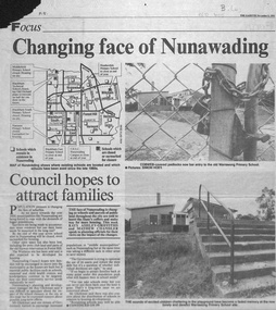
Newspaper - Article, Changing face of Nunawading, 8/09/1993
... burwood east... south primary school no. 4035 narmara primary school burwood ...Article from Nunawading Gazette, 1993, concerning the selling of so many schools in Nunawading and the impact of the increase of population from the extra houses being built.Article from Nunawading Gazette, 1993, concerning the selling of so many schools in Nunawading and the impact of the increase of population from the extra houses being built. The concern is whether sufficient public facilities will be available. Council would oppose any moves to close more schools.Article from Nunawading Gazette, 1993, concerning the selling of so many schools in Nunawading and the impact of the increase of population from the extra houses being built. land subdivision, school buildings, glickman, ray, abbott, kevin, dollis, dimitri, maclellan, robert, middlefield primary school, blackburn technical school, city of nunawading, blackburn south primary school, no. 4035, narmara primary school, burwood east, blackburn east primary school, no. 4800, forest hill secondary college, nunawading campus, heatherdale primary school, warrawong primary school -
Whitehorse Historical Society Inc.
Document, William James Moffatt, 2013
... Burwood East... Mitcham melbourne Moffatt William James Mahoneys Road Burwood East ...Biographical notes about William James Moffatt, orchardist in Blackburn.Biographical notes about William James Moffatt, orchardist in Blackburn.Biographical notes about William James Moffatt, orchardist in Blackburn.moffatt, william james, mahoneys road, burwood east, orchardists, bakers road blackburn -
Whitehorse Historical Society Inc.
Leisure object - Land Title, Moffatt land, 1907
... Mahoneys Road Burwood East... William James Mahoneys Road Burwood East Certificate of Title Vol ...Certificate of Title Vol. 3247 Fol. 346.Certificate of Title Vol. 3247 Fol. 346, 9 acres, 25 perches, Mahonys Road Burwood, 19 November 1907. Incl. transfers to MMBW 4 August 1926 and Arthur Vernon Moffatt 30 October 1934 by William James MoffattCertificate of Title Vol. 3247 Fol. 346.moffatt, arthur vernon, melbourne and metropolitan board of works, moffatt, william james, mahoneys road burwood east -
Whitehorse Historical Society Inc.
Map, City of Nunawading Street and Block Map
... Burwood Highway Burwood East... Burwood Highway Burwood East City of Nunawading City of Nunawading ...City of Nunawading Street and Block map.City of Nunawading Street and Block map. Scale: 1:10,000. with enlargement, Canterbury Road South to Burwood Highway.City of Nunawading Street and Block map. canterbury road nunawading, burwood highway burwood east, city of nunawading -
Whitehorse Historical Society Inc.
Article, Shed a tool for Wellbeing
... Burwood East.... Forest Hill Crossway Baptist Church Burwood East Forest Hill ...The Forest Hill College/Crossway Men's Shed is a joint initiative between the school and church and is located in the school grounds.The Forest Hill College/Crossway Men's Shed is a joint initiative between the school and church and is located in the school grounds to aid in the well-being of men in the community.The Forest Hill College/Crossway Men's Shed is a joint initiative between the school and church and is located in the school grounds. forest hill, crossway baptist church, burwood east, forest hill secondary college