Showing 488 items matching " first survey"
-
 Moorabbin Air Museum
Document - CAC Commonwealth Aircraft Corporation, Field Service Survey CA25 Winjeel 480 to 730
-
Moorabbin Air Museum
Document - CAC Commonwealth Aircraft Corporation, Field Service Survey CA25 Winjeel
-
Moorabbin Air Museum
Document (item) - CAC Collection - Fire Insurance - Underwriters' Survey Reports
-
Moorabbin Air Museum
Book - Air Dates A chronological survey of the principal events in the field of civil & military aviation, Air Commodore L G S Payne
-
Moorabbin Air Museum
Document (item) - Roland Jahne Collection - See Description for details
-
 Williamstown High School
Architecture text book 1947, A first book of architecture: a brief survey. G.H.Reed, M.A
Architecture textbook used by Bob Gerring while he attended Williamstown High School. This textbook was used while Bob was in Form 3B in 1947. 32 pages, back cover missing.Inside front cover: Robert Gerring Form IIIB W.H.S.williamstown high school, 1947, 1940's, textbooks, architecture, robert gerring -
Tatura Irrigation & Wartime Camps Museum
Book, Survey Sculpture and Graphic Works. 1922-1982, 1982
This book was first published to coincide with the exhibition mounted at the McCelland Gallery (A State Regional Gallelry), Langwarrin, Nov 7, 1982 to Jan. 15, 1983Soft covered black and white cover with copies of sculptures and white text on front cover and spine.Best Wishes, E de Jong-Duldig.ww2 camp 3 -
Tatura Irrigation & Wartime Camps Museum
Booklet, Solving the Mystery, 1978
Story of Catholic Church in Tatura. Education and early history of Tatura 1870's. First Catholic Church was built at Baldwinville/Byrneside 1878. Present Church built in 1912.Gold cover, green writing. Survey map on back, Certificate of Title details on front.solving the mystery, burton-clay fr r, catholicism in tatura, tatura, sacred heart church, books, history, local, religion -
Tatura Irrigation & Wartime Camps Museum
Booklet, Solving the Mystery, 1978
Story of Catholic Church in Tatura. Education and early history of Tatura 1870's. Present Church built in 1912. First Catholic Church was built at Baldwinville-Byrneside. 1878Gold cover.Green writing. Survey map on back, Certificate of Title details on front.sacred heart church, tatura, books, history, local, religion -
Tatura Irrigation & Wartime Camps Museum
Booklet, Solving The Mystery, 1978
Story of Tatura Catholic Church and Education. Early history of Tatura 1870's. Present church built in 1912Gold cover, green writing. Survey map on back. Written to explain the first Catholic Church was built at Baldwinsville-Byrneside in 1878.solving the mystery, catholicism in tatura, burton-clay father r, tatura, sacred heart church, books, history, local, religion -
 Villa Alba Museum
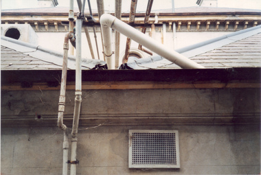
Photograph - Waste water pipes, c.1987
Built for William and Anna-Maria Greenlaw in the early 1880s, and with interiors decorated by the Paterson Bros, Villa Alba remained in private ownership until 1949. From 1950, the house was owned by a number of institutions. By 1984, the Villa Alba Preservation Society had been formed, and three years later, the Mount Royal Hospital granted a 25-year lease to Kew Council. In 2004, the title to Villa Alba was passed by the Victorian Government to The Villa Alba Museum Incorporated. The Museum, at 44 Walmer Street, Kew, is now a cultural institution committed to the collection, study and display of 19th century interior decorative finishes, and the components of 19th and 20th century interior decoration.This is one of a number of historically and aesthetically significant photos of the interiors and exterior of Villa Alba when it was still owned by the Mount Royal Hospital, showing twentieth century accretions and deterioration of the historic fabric of the building. This was a benchmark survey against which future conservation and restoration activities can be measured.In December 1987, Mockridge Stahle & Mitchell Pty Ltd Architects prepared ‘Villa Alba Survey: A Report on the fabric for Mount Royal Hospital’ of which this photograph is a part. Photo of numerous pipes, all installed during the period when the house was owned by the Royal Women's Hospital as a home for nurses (1950-1974). The pipes extended from a bathroom installed at the end of the first floor hall, running along the box gutter to the rear of the building. [The pipes were removed in subsequent restorations].villa alba museum, conservation photographs, victorian architecture, drain pipes, waste water -
 Villa Alba Museum
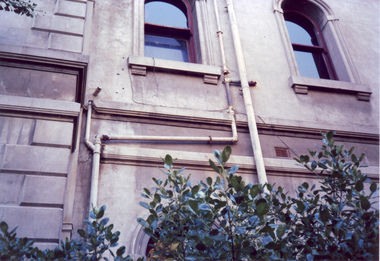
Photograph - Exterior pipe work, c.1987
Built for William and Anna-Maria Greenlaw in the early 1880s, and with interiors decorated by the Paterson Bros, Villa Alba remained in private ownership until 1949. From 1950, the house was owned by a number of institutions. By 1984, the Villa Alba Preservation Society had been formed, and three years later, the Mount Royal Hospital granted a 25-year lease to Kew Council. In 2004, the title to Villa Alba was passed by the Victorian Government to The Villa Alba Museum Incorporated. The Museum, at 44 Walmer Street, Kew, is now a cultural institution committed to the collection, study and display of 19th century interior decorative finishes, and the components of 19th and 20th century interior decoration.This is one of a number of historically and aesthetically significant photos of the interiors and exterior of Villa Alba when it was still owned by the Mount Royal Hospital, showing twentieth century accretions and deterioration of the historic fabric of the building. This was a benchmark survey against which future conservation and restoration activities can be measured.In December 1987, Mockridge Stahle & Mitchell Pty Ltd Architects prepared ‘Villa Alba Survey: A Report on the fabric for Mount Royal Hospital’ of which this photograph is a part. Photo of numerous pipes, all installed during the period when the house was owned by the Royal Women's Hospital as a home for nurses (1950-1974). The pipes extended from the roof and from rooms used as washrooms on the first floor.villa alba museum, conservation photographs, victorian architecture, drain pipes, waste water -
 Villa Alba Museum
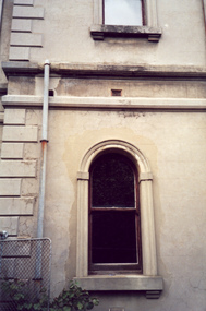
Photograph - Ground and first floor windows, c.1987
Built for William and Anna-Maria Greenlaw in the early 1880s, and with interiors decorated by the Paterson Bros, Villa Alba remained in private ownership until 1949. From 1950, the house was owned by a number of institutions. By 1984, the Villa Alba Preservation Society had been formed, and three years later, the Mount Royal Hospital granted a 25-year lease to Kew Council. In 2004, the title to Villa Alba was passed by the Victorian Government to The Villa Alba Museum Incorporated. The Museum, at 44 Walmer Street, Kew, is now a cultural institution committed to the collection, study and display of 19th century interior decorative finishes, and the components of 19th and 20th century interior decoration.This is one of a number of historically and aesthetically significant photos of the interiors and exterior of Villa Alba when it was still owned by the Mount Royal Hospital, showing twentieth century accretions and deterioration of the historic fabric of the building. This was a benchmark survey against which future conservation and restoration activities can be measured.In December 1987, Mockridge Stahle & Mitchell Pty Ltd Architects prepared ‘Villa Alba Survey: A Report on the fabric for Mount Royal Hospital’ of which this photograph is a part. Photo of one of two arched, rendered widows with later additions such as exterior drain pipe and gate.villa alba museum, conservation photographs, victorian architecture, cement render, windows -
University of Melbourne, Burnley Campus Archives
Letter - Photocopies and photograph, 1927-1930
1200 2 pages of Notes, written by C French Senior to the Jessep Esq. Starting with Royal Horticultural Society 1855, in Survey Paddock. Purpose of establishment of this enterprise; Committee men: The planting by C French of Taxodium Sempervirens: a great flood and its destruction of the Burnley Gardens: this letter is handwritten. A note from C French, dated 23/5/1929, adds further information to the notes. States that Burnley Gardens were laid out by M Lynch and W Harbison as curator. 1201 Handwritten letter by C French to Charlie, thanking him for sending a copy of an article from The Sun. He comments on omissions from the article, provides names of men involved in the first years of the development of the B Gardens, says a good deal about G Neilson. 2 pages. 1202 Letter addressed to Director Botanical Gardens. Refers to a W. Ward, a horticulturalist and the willow tree Huntingdon Willow - Salix Alba (coerulea) Letter written by Charles French. States that willows were sent to Bot Gardens by Sir Joseph Hooker of Kew. The use of this for cricket bats. Willows being setn to Victorian nurseries in 1850s from England. CF States that he planted the first tree Taxodium sempervirens, in Burnley Gardens. Tree presented by JJ Rule of Richmond. 2 pages. 1203 Letter to Charlie from Charles French, signed also Dad This letter is said to be accompanying notes on the B Gardens (Burnley or Botanic?) 1204 Letter to Jessep from Charles French. Mention of "Sequoia" sempervirens Endlicher the red wood planted at Burnley. 1 page5 letters from Charles French about early history of Burnley gardens- Refer to paper cataloguecharles french, gardens, sequoia, redwood, willow tree, use of willow for cricket bats, willow cricket bats, cricket, huntingdon willow, flood burnley gardens -
 Emerging Writers' Festival
2004 Emerging Writers' Festival Survey
... This is the audience survey, developed after the first... This is the audience survey, developed after the first Emerging Writers ...This is the audience survey, developed after the first Emerging Writers' Festival, held in 2004. Surveying and understanding the wants and needs of audiences has always been an important part of programming for the following year at the EWF.A black and white folded survey for audiences of the first Emerging Writers' Festival, held in 2004.2004 emerging writers' festival, richard watts, express media, literary programming, the wheeler centre, emerging writers', literary, festival, melbourne -
Koorie Heritage Trust
Book, Webb, Stephen G, Palaeopathology of Aboriginal Australians : health and disease across a hunter-gatherer continent, 1995
... . It represents the first continental survey of its kind as well as being ...This book is a study of the health of Australia's inhabitants over 50,000 years. It represents the first continental survey of its kind as well as being the first to quantify and describe many important aspects of Australian hunter-gatherer health.xii, 324 p. : ill. ; 26 cm.This book is a study of the health of Australia's inhabitants over 50,000 years. It represents the first continental survey of its kind as well as being the first to quantify and describe many important aspects of Australian hunter-gatherer health.paleopathology -- australia. | aboriginal australians -- diseases -- history. | aboriginal australians -- health and hygiene -- history. | paleopathology. | paleopathology -- australia. | disease. | health. | hygiene. -
Whitehorse Historical Society Inc.
Article, Janette is waste wise, 18/09/1991 12:00:00 AM
Article from Nunawading Post on a 10 year old Janette Lewis from Forest Hill.Article from Nunawading Post on a 10 year old Janette Lewis from Forest Hill winning first place in a state-wide science competition for her survey on domestic garbage and waste minimisation.Article from Nunawading Post on a 10 year old Janette Lewis from Forest Hill. lewis, janette, garbage collection -
 Rutherglen Historical Society
Map, 1908
This is a map produced as part of a book entitled.. It is also stamped on the back in blue ink with an oval ring and the words North of England Institute. Newcastle. Mining & Meterolgical Faculty. Purchased on 23rd July 2017 by the Society after research by member Simon Killeen. Mining map of one of the first mines in Rutherglen area ( Chiltern West)Cream paper, black printing, rectangle with a drawingGeographical Survey of Victoria, Memoir, No6. Plate XX Plan of Underground Workings CHILTERN VALLEY CONSOLS MINE, RUTHERGLEN, PARISH OF CHILTERN WESTgold, rutherglen, mining, chiltern, underground mine map, geological survey, reef drives -
 Ballarat Heritage Services
Photograph - Colour, Earth Banks, Old Sarum, England, 2016, 01 November 2016
William the Conqueror inherited Old Sarum from the last Saxon king of England. It was an ideal site for a royal castle. It was here in 1070 that William paid off his army after a long and bitter campaign in northern England. It was here in 1086 that he called together all the major landholders in England so they could swear allegiance to him. It was a crucial moment. The Domesday Book was being written, a threatened Viking invasion had only just been averted and William's eldest son was in armed rebellion. Old Sarum was an important place where this Norman king of England held power. In 1794 the Ordnance Survey set out to check the accuracy of the first mapping of Southern England, which had begun ten years earlier. From a point just below Old Sarum Lieutenant William Mudge laid out a base-line 36,574 feet (11,253 metres) long. From each end of the line the positions of distant places were plotted using a huge theodolite made in 1791 by Jesse Ramsden. The accuracy of the process, which was repeated all over England, depended on Jesse Ramsden's craftsmanship and on William Mudge's surveying skill in setting out this first base-line from Old Sarum. The nearer end of Mudge's line is marked by an inscribed stone beside the modern A345 at Old Sarum. ordnance survey, william mudge, jesse ramsden, william the conqueror, old sarum, saxon, 1086, england -
 Ballarat Heritage Services
Photograph - Colour, Earth Banks, Old Sarum, England, 01 November 2016
William the Conqueror inherited Old Sarum from the last Saxon king of England. It was an ideal site for a royal castle. It was here in 1070 that William paid off his army after a long and bitter campaign in northern England. It was here in 1086 that he called together all the major landholders in England so they could swear allegiance to him. It was a crucial moment. The Domesday Book was being written, a threatened Viking invasion had only just been averted and William's eldest son was in armed rebellion. Old Sarum was an important place where this Norman king of England held power. In 1794 the Ordnance Survey set out to check the accuracy of the first mapping of Southern England, which had begun ten years earlier. From a point just below Old Sarum Lieutenant William Mudge laid out a base-line 36,574 feet (11,253 metres) long. From each end of the line the positions of distant places were plotted using a huge theodolite made in 1791 by Jesse Ramsden. The accuracy of the process, which was repeated all over England, depended on Jesse Ramsden's craftsmanship and on William Mudge's surveying skill in setting out this first base-line from Old Sarum. The nearer end of Mudge's line is marked by an inscribed stone beside the modern A345 at Old Sarum. ordnance survey, william mudge, jesse ramsden, william the conqueror, old sarum, saxon, 1086, england -
 Ballarat Heritage Services
Photograph - Colour, Stonework, Old Sarum, England, English Heritage Site, 01 November 2016
William the Conqueror inherited Old Sarum from the last Saxon king of England. It was an ideal site for a royal castle. It was here in 1070 that William paid off his army after a long and bitter campaign in northern England. It was here in 1086 that he called together all the major landholders in England so they could swear allegiance to him. It was a crucial moment. The Domesday Book was being written, a threatened Viking invasion had only just been averted and William's eldest son was in armed rebellion. Old Sarum was an important place where this Norman king of England held power. In 1794 the Ordnance Survey set out to check the accuracy of the first mapping of Southern England, which had begun ten years earlier. From a point just below Old Sarum Lieutenant William Mudge laid out a base-line 36,574 feet (11,253 metres) long. From each end of the line the positions of distant places were plotted using a huge theodolite made in 1791 by Jesse Ramsden. The accuracy of the process, which was repeated all over England, depended on Jesse Ramsden's craftsmanship and on William Mudge's surveying skill in setting out this first base-line from Old Sarum. The nearer end of Mudge's line is marked by an inscribed stone beside the modern A345 at Old Sarum. ordnance survey, william mudge, jesse ramsden, william the conqueror, old sarum, saxon, 1086, england -
 Ballarat Heritage Services
Photograph - Colour, Stonework, Old Sarum, England, English Heritage Site, 2016, 01 November 2016
William the Conqueror inherited Old Sarum from the last Saxon king of England. It was an ideal site for a royal castle. It was here in 1070 that William paid off his army after a long and bitter campaign in northern England. It was here in 1086 that he called together all the major landholders in England so they could swear allegiance to him. It was a crucial moment. The Domesday Book was being written, a threatened Viking invasion had only just been averted and William's eldest son was in armed rebellion. Old Sarum was an important place where this Norman king of England held power. In 1794 the Ordnance Survey set out to check the accuracy of the first mapping of Southern England, which had begun ten years earlier. From a point just below Old Sarum Lieutenant William Mudge laid out a base-line 36,574 feet (11,253 metres) long. From each end of the line the positions of distant places were plotted using a huge theodolite made in 1791 by Jesse Ramsden. The accuracy of the process, which was repeated all over England, depended on Jesse Ramsden's craftsmanship and on William Mudge's surveying skill in setting out this first base-line from Old Sarum. The nearer end of Mudge's line is marked by an inscribed stone beside the modern A345 at Old Sarum. ordnance survey, william mudge, jesse ramsden, william the conqueror, old sarum, saxon, 1086, england -
 Ballarat Heritage Services
Photograph - Colour, Stonework and well, Old Sarum, England, English Heritage Site, 2016, 01 November 2016
William the Conqueror inherited Old Sarum from the last Saxon king of England. It was an ideal site for a royal castle. It was here in 1070 that William paid off his army after a long and bitter campaign in northern England. It was here in 1086 that he called together all the major landholders in England so they could swear allegiance to him. It was a crucial moment. The Domesday Book was being written, a threatened Viking invasion had only just been averted and William's eldest son was in armed rebellion. Old Sarum was an important place where this Norman king of England held power. In 1794 the Ordnance Survey set out to check the accuracy of the first mapping of Southern England, which had begun ten years earlier. From a point just below Old Sarum Lieutenant William Mudge laid out a base-line 36,574 feet (11,253 metres) long. From each end of the line the positions of distant places were plotted using a huge theodolite made in 1791 by Jesse Ramsden. The accuracy of the process, which was repeated all over England, depended on Jesse Ramsden's craftsmanship and on William Mudge's surveying skill in setting out this first base-line from Old Sarum. The nearer end of Mudge's line is marked by an inscribed stone beside the modern A345 at Old Sarum. ordnance survey, william mudge, jesse ramsden, william the conqueror, old sarum, saxon, 1086, england