Showing 279 items matching " geological map"
-
 Bendigo Historical Society Inc.
Map - UNITED HUSTLER'S & REDAN & K. K. MINES - PLAN OF THE UNITED HUSTLER'S & REDAN & K. K. MINES
Plan of the United Hustler's & Redan & K. K. Mines Bulletin No 33 Plate No XXXI. Shows depth of levels, Probable positions of reefs and natural surface with the poppet legs at the two shafts. Sill of shaft of the K. K. Mine 773.56 ft above Sea Level and sill of shaft of the United Hustler's & Redan Mine 745.62 above Sea Level. Also mentioned is the average amount of gold obtained per ton. Note on the top of page - Plates 4, 8, 13, 20, 26 & 31 form a Longitudinal Section from Fortuna Hustler's to Hustler's Consols Mine. Geological Survey of Victoria emblem and signed by H S Whitelaw, Underground Survey Office, Bendigo, September 1913. mining, parish map, united hustler's & redan & k. k. mines, geological survey of victoria, h s whitelaw, underground survey office bendigo -
 Bendigo Historical Society Inc.
Map - UNITED HUSTLER'S & REDAN & K. K. MINES - PLAN OF UNITED HUSTLER'S & REDAN & K. K. MINES
Plan of the United Hustler's & Redan & K. K. Mines on the Hustler's Line of Reefs Bulletin No 33 Plate No XXVII. Plan shows depth of levels, Long Gully, Hustler's Line of Reefs, Lightning Hill Line of Reefs and approximate Boundary of Lease. Also mentions Comet Co. Geological Survey of Victoria emblem and signed by H S Whitelaw, Underground Survey Office Bendigo September 1913.mining, parish map, united hustler's & redan & k. k. mines, long gully, hustler's line of reefs, lightning hill line of reefs, comet co, h s whitelaw, geological survey of victoria, underground survey office -
 Bendigo Historical Society Inc.
Map - UNITED HUSTLER'S & REDAN & K. K. MINES - PLAN OF UNITED HUSTLER'S & REDAN & K. K. MINES
Plan of the United Hustler's & Redan & K. K. Mines on the Hustler's Line of Reefs Bulletin No 33 Plate No XXVIII. Plan shows depth of levels, stone encountered and some geological features. Geological Survey of Victoria emblem and signed by H S Whitelaw, Underground Survey Office Bendigo, September 1913. mining, parish map, united hustler's & redan & k. k. mines, united hustler's and redan shaft, k. k. shaft, h s whitelaw -
 Bendigo Historical Society Inc.
Map - UNITED HUSTLER'S & REDAN MINE - TRANSVERSE SECTIONS N & S OF SHAFT UNITED HUSTLER'S & REDAN MINE
Transverse Sections N & S of Shaft United Hustler's & Redan Mine on the Hustler's Line of Reef Bulletin No 33, Plate No XXX. Map shows some of the stone encountered on the levels and depth. Geological Survey of Victoria emblem and signed by H A Whitdan, Underground Survey Office Bendigo, September 1913.mining, parish map, united hustler's & redan mine, transverse sections n & s of shaft united hustler's & redan mine, hustler's line of reef -
 Clunes Museum
Map, Surface Geology Plan
... WITH WORKINGS MARKED - LAMINATED Surface Geology Plan Map MAP ...Plans show various shaft locations.1 Photocopy of Plan Block 23/19 Scale 1 inch = 100 feet .2 Photocopy of Plan Block 19/19 Scale 1 inch = 100 feet .3 AERIAL PHOTOGRAPH WITH WORKINGS MARKED - LAMINATED.1 C-21 North Broken Hill Ltd Clunes Block 23/19 .2SOUTH CLUNES MINE Ltd Clunes Block 19/19north broken hill ltd, surface geology plan -
 Falls Creek Historical Society
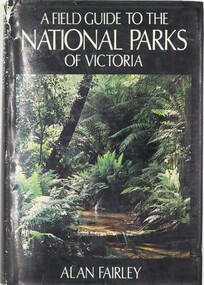
Book - A Field Guide to the National Parks of Victoria, Alan Fairley, January 1, 1982
This book serves as a comprehensive guide to reserves managed by the National Parks Service in Victoria, covering various aspects like history, geology, flora, fauna, and recreational activities. It divides Victoria into several parts, each with dedicated chapters for national parks, including detailed maps and entry points. Other reserves like State and coastal parks are grouped in a separate chapter. The content spans the diverse landscapes of Victoria, from Lower Glenelg to Burrowa Pine Mountain and the Alps to the desert, describing various types of soil, vegetation, animals, and natural beauty. It is intended for individuals who appreciate the outdoors, conservation, and bushwalking in the Australian bush.A volume of 363 pages 363 pages including 32 colour photos as well as illustrations and maps. It also includes a detailed index and bibliography. This book serves as a comprehensive guide to reserves managed by the National Parks Service in Victoria, covering various aspects like history, geology, flora, fauna, and recreational activities. It divides Victoria into several parts, each with dedicated chapters for national parks, including detailed maps and entry points. Other reserves like State and coastal parks are grouped in a separate chapter. The content spans the diverse landscapes of Victoria, from Lower Glenelg to Burrowa Pine Mountain and the Alps to the desert, describing various types of soil, vegetation, animals, and natural beauty. It is intended for individuals who appreciate the outdoors, conservation, and bushwalking in the Australian bush.national parks and reserves, environment victoria, national parks victoria guide -
 Federation University Historical Collection
Book, Final recommendations Ballarat Study Area Land Conservation Council, Victoria, 1982, 1982
Yellow soft covered report of 95 pages . The contents of the report include: Parks, reference areas, wildlife reserves, water production, hardwood production, softwood production, flora Reserves and Flora and Fauna reserves, bushland reserves, historic area and reserves, rivers and streams, Roadside conservation and Highway parks, Education areas and School Plantations, Lake Reserves, geological reserves, recreation, scenic reserves, agriculture, mineral and stone production, utilities and survey, township land, Uncommitted Land, military training, other reserves and public land. Maps include: The Study area 1: 250 000 Supplementary Mapsland conservation authority, ballarat, endowment plantations, pine plantations, langi ghiran state park, mount buangor state park, enfield state park, ballarat-creswick regional park, rossbridge, black lake, flax mill swamp, dereel lagoon, lake bolac, lake wongan, langi ghiran reservoir, gong gong reservoir, pincotts reservoir, beales reservoir, wilsons reservoir, moorabool reservoir, korweinguboora, korweinguborra reservoir, learmonth bores, sago hill, illabarook reservoir, ballarat water commission, dunneworthy, mount cole, mont lonarch, ben major, waterloo, trawalla, linton, ross creek, canadian, shepherds flat, lal lal, mount doran, raglan, chute, carngham, buninyong, watsons hill, enfield, cape clear, illabrook, rokewood junction, mount warrenheip, nerrina, jubilee, golden stream, australasian deep lead mine, happy valley school, piggoreet, berringa, bulldog, ballarat common, wildlife, water, timber, flora, rivers, geology, agriculture, warrenheip, biodiversity -
Glen Eira Historical Society
Letter - Rosstown Railway
This file contains four items: 1/A black and white photocopy of a letter dated either 07/08/1889 or 09/08/1889, from Robert Lundon to an unidentified recipient discussing an agreement reached between the author – on behalf of the recipient – and Soon Hang Hi in regard, in regards to the allotment known as Webber’s. The agreement is outlined in the letter in what appears to be Chinese characters, and includes the marks of Robert Lundon and Soon Hang Hi. File note from Joy Wu states that the calligraphy is not Mandarin or traditional Chinese. 2/Three sheets of hand-written working notes with information taken from the Victorian Government Gazette on THE ROSSTOWN AND MURRUMBEENA LAND COMPANY LIMITED, THE ROSSTOWN JUNCTION RAILWAY AND PROSPERITY COMPANY LIOMITED, and THE ROSSTOWN JUNCTION, ELSTERNWICK, AND OAKLEIGH RAILWAY COMPANY LIMITED, covering dates between 1887 and 1894. The notes concern meetings and creditors claims relevant to the companies, with reference numbers for the information source. Date and author of the notes are not recorded. 3/A black and white photocopy of the a partial map of the Rosstown Railway and surrounding area, undated. The map includes the names of landholders in the areas of Brighton, Garden Vale and Elsternwick, as well as other railway lines present in the region. 4/A fold-out map and guide of the Rosstown Rail Trail, including a brief general history of Caulfield as well as a more extensive biography of William Murray Ross and the Rosstown Railway. The map marks and describes significant sites along the trail, including photographs of some of these sites, provided by DF Jowett.documents, correspondence, webber’s, lundon robert, chinese characters, ethnic communities, signatures, text, settlements, taxes, fraser john grieves, lovell r.h., price davies, meetings, communication activities, soon hang hi, commercial events and activities, the rosstown and murrumbeena land company limited, victorian government gazette, bulmer richard, parry john, osment henry, shareholders, creditors claims, the rosstown junction railway and property company limited, finch and best, lawyers, the rosstown junction elsternwick and oakleigh railway company limited, cameron w.c., phillips p.d., garden vale, elsternwick, elsternwick railway station, rosstown, rosstown railway, thomas street, bay street, kooyong road, melbourne and brighton railway, hawthorn road, bambra road, caulfield and frankston railway, booran road, grange road, koornang road, murrumbeena road, north road, north road railway station, east brighton railway station, south road, railway routes, railway lines, railways, land transport, murphy j., caulfield, hamilton t.f., dane p., holloway, webb, ailee john, payne t.b., brodie chas, dane john, o’neil h., mccombie john, mcmillane a., smyth c.d., cooper, ebden, landholders, jeffrey j.d., gill j., balcombe a.e., cooper h., mcnab j., white j., sutherland j., greeves a.f.a., newton m.c., chamley f.b., fowler j., inglis p., grant t., stooke j., swanson g., cochrane c., adams e.b., mccombie thas, keyes robert, brighton cemetery, burials grounds and graveyards, war-ein road, were j.b., holland j., mcmahon c., winter t.l.m., dendy henry, mitchell w., jackson s., were j.e., wickham francis dawe, bryant jane, east brighton railway station, railway stations, maps, allotments, land titles, roads and streets, rosstown rail trail, city of glen eira, tourism, trains, tourism information bureaus, tours, pamphlets, elsternwick railway park, oakleigh junction, princes park, ee gunn reserve, packer park, sites, jowett d.f., weickhardt i.g., return to rosstown: railways land sales and sugar beet ventures in caulfield, land sales, walking trails, ross william murray, transport objects, locomotion, walking, cycling, driving, sports, country mansions, people, caulfield john, builders, construction and demolition workers, occupations, careers, professionals, topography, geology, landforms, horticulture, market gardens, primary industry workers, city of caulfield, mood kee, pennington harold, annual general meetings, caulfield town hall, glen eira city council, carnegie, carnegie station, rosstown station, people by circumstance, migrants, sugar beet, sugar beet mill, sugar beet industry, mills, factories, sea beach lines, bent thomas, parliamentary representatives, neville street, miller street, lemann’s swamp reserve, koornang park, cane sugar industry, breweries, rabbit processing plants, health establishments, hospitals, food production establishments, abattoirs, thieves, social problems, vagrants, theft, squatting, financial economics, debt, finance industry, insurance companies, company managers, bentleigh, ross leila, the grange, leila road, wild cherry road, financial trouble, mortgages, gisborne street, archibald street, riddell parade, victoria railways, glen huntly road, clarence street, college street, gladstone parade, parrell street, aileen avenue, seaview street, land subdivisions, dover street, sussex street, landfill, marara road, booran road, woodville avenue, dorothy avenue, ormond park, royal avenue, ormond railway station, oakleigh road, melten avenue, miller street, munro avenue, lord reserve, neerim road, toolambool road, the rosstown hotel, rosanna street, murrumbeena crescent, commercial establishments, the national bank, rosstown road, kangaroo road, poath road, freda street, hughesdale kindergarten, oakleigh council, hughesdale community centre, civic establishments, galbally reserve, plaques, warrigal road, out and about brochures, orion estate -
 Monbulk RSL Sub Branch
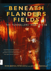
Book, Peter Barton, Beneath Flanders fields the tunnellers' war, 1914-1918, 2005
In the Ypres Salient, the secret struggle beneath no man's land became one of engineering, technology and science - and of carefully calculated assassination. This book reveals how this most intense of battles was fought and won. Few on the surface knew the horrific details of the tunnellers work, yet this silent, claustrophobic conflict was a barbaric struggle that raged day and night for almost two and a half years. On 7 June 1917 the most dramatic mine offensive in history at Messines Ridge opened. After Messines, the tunnellers turned to the construction of deep dugouts, structures which housed tens of thousands of troops, men for whom life on the surface had become almost untenable. Often electrically lit and ventilated, they incorporated headquarters, cookhouses, soup kitchens, hospitals, drying rooms and workshops. Hundreds were built, and thanks to the Flanders geology many still survive today, and are can be seen in photographs in this book.Index, ill, maps, p.305.non-fictionIn the Ypres Salient, the secret struggle beneath no man's land became one of engineering, technology and science - and of carefully calculated assassination. This book reveals how this most intense of battles was fought and won. Few on the surface knew the horrific details of the tunnellers work, yet this silent, claustrophobic conflict was a barbaric struggle that raged day and night for almost two and a half years. On 7 June 1917 the most dramatic mine offensive in history at Messines Ridge opened. After Messines, the tunnellers turned to the construction of deep dugouts, structures which housed tens of thousands of troops, men for whom life on the surface had become almost untenable. Often electrically lit and ventilated, they incorporated headquarters, cookhouses, soup kitchens, hospitals, drying rooms and workshops. Hundreds were built, and thanks to the Flanders geology many still survive today, and are can be seen in photographs in this book. world war 1914-1918 - campaigns - france, world war 1914-1918 - tunnellers