Showing 423 items matching " map of system"
-
 Bacchus Marsh & District Historical Society
Map, Plan of part of the road district of Bacchus Marsh circa 1856-1862
Local government in much of Victoria including the Bacchus Marsh area began with the formation of 'local committees'. These local committees could make representations to a Central Road Board regarding plans for road construction. Road construction and maintenance were seen as the essential tasks of these early local government authorities. By 1856 the local committee in Bacchus Marsh was constituted as the Bacchus Marsh Road District. This entity continued until 1862 when the name changed to the Bacchus Marsh and Maddingley Road District. This new entity lasted until 1871 when the local government authority in accordance with new statewide legislation became known as the Shire of Bacchus Marsh. The title of this plan being a plan of 'a portion of the road district of Bacchus Marsh' suggests that the plan was produced sometime between 1856 and 1862. The main purpose of this map was to shown the irrigable land in the district and the sources from which water for irrigation could be drawn. Bacchus Marsh was an early irrigation district in Victoria. Irrigation trusts were formed in the 1880s and 1890s to manage irrigation districts. But this was the culmination of many years of earlier attempts to construct irrigation systems in the Bacchus Marsh area and create a system to manage irrigation more broadly. This map dating from around 1856-1862 is an important cartographic document which provides evidence of how the early planning for irrigation was developing in the Bacchus Marsh region.A single page paper map showing a plan of part of the road district of Bacchus Marsh. The map is pasted into a bound volume containing 76 maps or plans in total. High resolution digital image stored on BMDHS computer network. bacchus marsh victoria maps, bacchus marsh road district, local government, road districts, irrigation -
 Melbourne Tram Museum
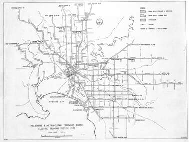
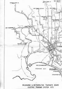
Drawing, Melbourne & Metropolitan Tramways Board (MMTB), "Melbourne & Metropolitan Tramways Board Electric Tramway System 1979", 1979
... system in 1979 trams tramways map mmtb trackwork depots route ...Drawing of the track plan for the Melbourne Tramway System in 1979 over two separate sheets - titled "Melbourne & Metropolitan Tramways Board Electric Tramway System 1979". Shows the route numbers and terminus names, depot locations, rail lines, cross overs and junctions. Has the name J.Chau in bottom left hand corner. Yields information about the the Melbourne tram system in 1979Drawing - print on paper P15060. Two copies held.trams, tramways, map, mmtb, trackwork, depots, route numbers, railways, junction -
 Greensborough Historical Society
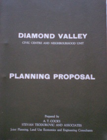
Document - Planning Document, Diamond Valley Civic Centre and Neighbourhood Unit: Planning Proposal, 1960s
This document proposes the change of land use from farming and quarrying to residential. This also includes the proposal for a Civic Centre in the (then) Shire of Diamond Valley. The plans listed in the 'Schedule of Plans' on last page are missing.Includes proposal for the Aqueduct to be converted to an underground system. Includes statistics relating to population increase. Dark brown plastic folder. 23 foolscap-size pages. Maps, Application for Permits to subdivide land in the Greensborough area.partington family, mitchell family, whittingham family, albion reid, diamond valley civic centre, shire of diamond valley -
 Victorian Railway History Library
Book, West Coast Wilderness Railway, Abt System, 2002
... in Tasmania. ill, maps, p.16. Abt System Book West Coast Wilderness ...A brief history of the narrow gauge 3'6" Abt Railway from Strachan to Queenstown in Tasmania.ill, maps, p.16.non-fictionA brief history of the narrow gauge 3'6" Abt Railway from Strachan to Queenstown in Tasmania.west coast wilderness railway - tasmania - history, narrow gauge railroads - australia - history -
 Victorian Railway History Library
Book, Barber, Simon, Changing Before Our Eyes Images of The Westrail System 1982-1998, 1998
... of the changes on the Westrail system between 1982 & 1998. ill, maps, p ...A pictorial record of the changes on the Westrail system between 1982 & 1998.ill, maps, p.96.non-fictionA pictorial record of the changes on the Westrail system between 1982 & 1998.railroad operations - australia - pictorial, railroads -- australia -- trains -- pictorial works -
 Victorian Railway History Library
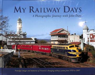
Book, Dare, John, My Railway Days: A Photographic Journey with John Dare, 2015
Nostalgic images and memories of Victoria's changing railway system from 1970 to 2007 from photographer John Dare.ill, maps, p.160.Nostalgic images and memories of Victoria's changing railway system from 1970 to 2007 from photographer John Dare.railroads - victorian railways - personal reminiscence, railroad operations - victoria - history -
 Victorian Railway History Library
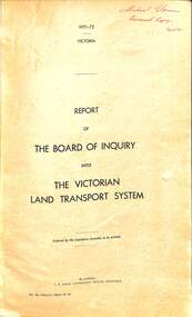
Book, Board of Inquiry, Report of The Board of Inquiry into The Victorian Land Transport System, 1972
A report by the Board of Inquiry into the Victorian land transport system in the years 1971 to 1972.maps. p.250.non-fictionA report by the Board of Inquiry into the Victorian land transport system in the years 1971 to 1972.land transport - victoria - report, railroad operations - victoria - history -
 Victorian Railway History Library
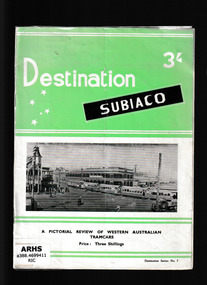
Book, Traction Publications, Destination Subiaco, 1957
... A history of the tramway systems of Western Australia Ill, maps, p ...A history of the tramway systems of Western AustraliaIll, maps, p.18.non-fictionA history of the tramway systems of Western Australiatramways - western australia, urban transport - australia -
 Victorian Railway History Library
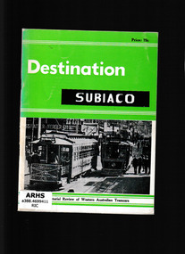
Book, Traction Publications, Destination Subiaco, 1967
... A history of the tramway systems of Western Australia Ill, maps, p ...A history of the tramway systems of Western AustraliaIll, maps, p.51.non-fictionA history of the tramway systems of Western Australiatramways - western australia, urban transport - australia -
 Victorian Railway History Library
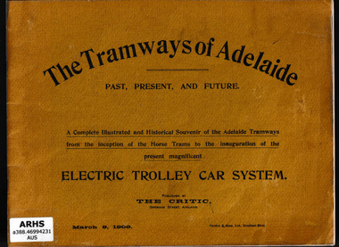
Book, Australian Electric Transport Museum (South Australia), The tramways of Adelaide, 197?
... trolley car system Ill, maps, p.50. The tramways of Adelaide Book ...Facsimile production of "The Tramways of Adelaide" published by The Critic, March 9, 1909. It is a complete illustrated and historical souvenir of the Adelaide tramways from the inception of the horse trams to the inauguration of the present magnificent electric trolley car systemIll, maps, p.50.non-fictionFacsimile production of "The Tramways of Adelaide" published by The Critic, March 9, 1909. It is a complete illustrated and historical souvenir of the Adelaide tramways from the inception of the horse trams to the inauguration of the present magnificent electric trolley car systemtramways - adelaide, local transit - adelaide -
 Victorian Railway History Library
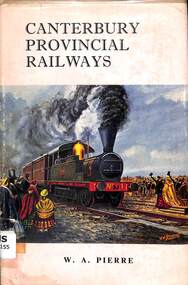
Book, Pierre, W.A, Canterbury Provincial Railways - Genesis of the N.Z.R System, 1964
A history of the Canterbury Provincial Railway out of Christchurch in the South Island New Zealand from it's 5'3" gauge days.index, ill, maps, p.190.non-fictionA history of the Canterbury Provincial Railway out of Christchurch in the South Island New Zealand from it's 5'3" gauge days.railroads - new zealand - south island - history, railroads construction - new zealand -
 Victorian Railway History Library
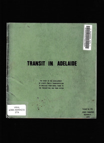
Book, State Transport Authority, Transit in Adelaide, 1978
... trams to the present bus and tram system Ill, maps, p.20 ...The story of the development of street public transportation in Adelaide from horse trams to the present bus and tram systemIll, maps, p.20.non-fictionThe story of the development of street public transportation in Adelaide from horse trams to the present bus and tram systemtramways - adelaide, horse tramways - adelaide -
 Victorian Railway History Library
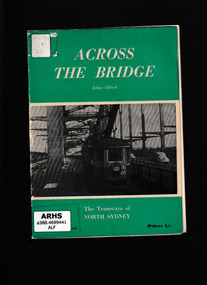
Booklet, Traction Publications, Across the bridge, 1960
: The tramways of North Sydney were quite separate from the main system and possessed many unusual features which endeared them to their passengers.Ill, maps, p.38.non-fiction: The tramways of North Sydney were quite separate from the main system and possessed many unusual features which endeared them to their passengers.tramways - sydney, tramways - north sydney -
 Victorian Railway History Library
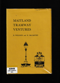
Book, South Pacific Electric Railway, Maitland tramway ventures, 1965
... to have a tramway system Index, bib, ill, maps, p.79. Maitland ...Apart from Broken Hill, Maitland was the only New South Wales regional city to have a tramway systemIndex, bib, ill, maps, p.79.non-fictionApart from Broken Hill, Maitland was the only New South Wales regional city to have a tramway systemtramways - maitland, steam trams - maitland -
 Victorian Railway History Library
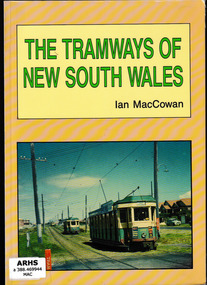
Book, Ian MacCowan, The tramways of New South Wales : a pictorial and detailed history of the horse, steam, cable, and electric passenger tramways in the first formed state of Australia, 1992
An account of the various tramway systems in New South Wales including horse drawn and cable carsIll, maps, p.152.non-fictionAn account of the various tramway systems in New South Wales including horse drawn and cable carstramways - new south wales, steam trams - new south wales, cable tramways - new south wales -
 Victorian Railway History Library
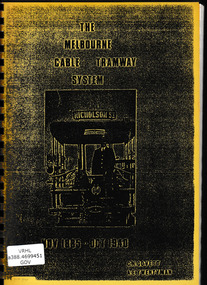
Book, C.N. Govett, A.E. Twentyman, The Melbourne cable tramway system : Nov 1885 - Oct 1940, 1973
... descripion of The Melbourne cable tramway system. Ill, facsim, maps ...A detailed descripion of The Melbourne cable tramway system.Ill, facsim, maps, p.200.non-fictionA detailed descripion of The Melbourne cable tramway system.tramways - melbourne, cable trams - melbourne -
 Victorian Railway History Library
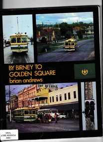
Book, Southern Cross Traction, By Birney to Golden Square : the last years of Bendigo's tramway, 1973
A portrait of Bendigo's tramway system in its final yearsIll, maps, p.74.non-fictionA portrait of Bendigo's tramway system in its final yearstramways - bendigo, trams - bendigo - history -
 Victorian Railway History Library
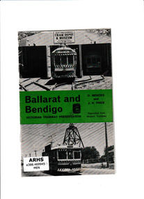
Booklet, D Menzies et al, Ballarat and Bendigo, ????
Brief history of the tramway systems of Bendigo, Ballarat and GeelongIll, maps, p.11.non-fictionBrief history of the tramway systems of Bendigo, Ballarat and Geelongtramways - geelong, tramways - ballarat, tramways - bendigo -
 Victorian Railway History Library
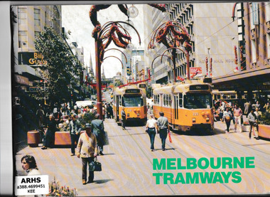
Book, Transit Press, Melbourne Tramways, 1985
... The vehicles, routes and workshops of the Melbourne tramway system Ill ...The vehicles, routes and workshops of the Melbourne tramway systemIll, maps, p.84.non-fictionThe vehicles, routes and workshops of the Melbourne tramway systemtramways - melbourne - history, tramways - melbourne -
 Victorian Railway History Library
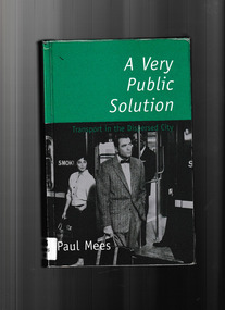
Book, Melbourne University Press, A very public solution : transport in the dispersed city, 2000
In A Very Public Solution, Paul Mees compares Melbourne's public transport system with the highly successful system in Toronto - a 'dispersed' city very like Melbourne with its suburban sprawl - and sheds new light on a century-old debate." "A Very Public Solution is for everyone concerned with urban sustainability and our growing traffic problems.Index, bib, maps, p.331.non-fictionIn A Very Public Solution, Paul Mees compares Melbourne's public transport system with the highly successful system in Toronto - a 'dispersed' city very like Melbourne with its suburban sprawl - and sheds new light on a century-old debate." "A Very Public Solution is for everyone concerned with urban sustainability and our growing traffic problems.urban transportation - melbourne, local transit - melbourne, local transit - ontario -
 Victorian Railway History Library
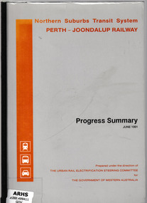
Booklet, Urban Rail Electrification Steering Committee, Northern suburbs transit system, Perth-Joondalup railway : progress summary, 1991
... in Perth Ill, maps, p.28. Northern suburbs transit system, Perth ...Progress report on the construction of the Northern suburbs transit system in PerthIll, maps, p.28.non-fictionProgress report on the construction of the Northern suburbs transit system in Perthurban transport - perth, suburban railways - perth -
 Victorian Railway History Library
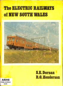
Book, Dornan, S.E, The Electric Railways of New South Wales, 1976
A brief history of the electrified railway system operated by the New South Wales Government from 1926 to 1976.ill, maps, p.96.non-fictionA brief history of the electrified railway system operated by the New South Wales Government from 1926 to 1976.railroad operations - new south wales - history, electric trains - new south wales - history -
 Melbourne Tram Museum
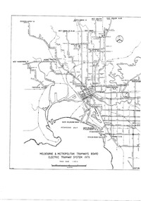
Drawing, Melbourne & Metropolitan Tramways Board (MMTB), "MMTB Electric Tramway System 1979", 1979 original
See item 7740 for an original print.Digital image of a drawing titled "MMTB Electric Tramway System 1979", giving a detailed layout of the Melbourne tram system in 1979. shows depot, storage depots, workshops and tramway terminus names and route numbers. See htd253i.pdf for a high definition pdf file - this does not open on this system - Two page document. See Reg Item 1765 for a 1971 copy.trams, tramways, mmtb, melbourne, map, routes -
 Melbourne Tram Museum
Drawing, Melbourne & Metropolitan Tramways Board (MMTB), "Melbourne & Metropolitan Tramways Board Electric Tramway System 1979", 1979
Photocopy of the track plan for the Melbourne Tramway System in 1979 over two separate sheets - titled "Melbourne & Metropolitan Tramways original pr Board Electric Tramway System 1979". Shows the route numbers and terminus names, depot locations, rail lines, cross overs and junctions. Has the name J.Chau in bottom left hand corner. See item 7740 for an original print.trams, tramways, melbourne, map, trackwork, depots, route numbers, railways, junction -
 Bendigo Military Museum
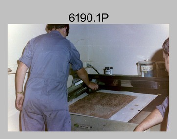
Photograph - Lithographic Technicians preparing a Cromalin map proof at the Army Survey Regiment, Fortuna Villa Bendigo, c1990s
These six photographs were most likely taken in the 1990s in Lithographic Squadron at the Army Survey Regiment, Fortuna, Bendigo. There is no annotation describing the date or personnel in the photographs. Cromalin proofing was a laminate and dry powder proofing system introduced in 1978. The system allowed the production of true to colour proofs, mainly for the proofing of orthophoto maps and process printed 1:250,000 JOG that used positive printing plates. It was upgraded in 1986. The pre-press proof was a cost-effective way of producing a one-off visual copy of the map or chart product. It enabled cartographers to perform a quality inspection and correct any faults before publication. The pre-press proof was deemed authoritative before its release to Print Troop for bulk printing and distribution.This is a set of six photographs of lithographic technicians preparing Cromalin map proofs at the Army Survey Regiment, Bendigo c1990s. The photographs were on 35mm negative film and were scanned at 96 dpi. They are part of the Army Survey Regiment’s Collection. .1) to .6) - Photo, colour, c1990s, printer technician SPR Shona Hastie, Lithographic Squadron. .1P to .6P – no annotationroyal australian survey corps, rasvy, army survey regiment, army svy regt, fortuna, asr, litho -
 Bendigo Military Museum
Photograph - RSM-Army Visit – Technical Tour, Army Survey Regiment Fortuna, Bendigo, 1989
This is a set of 16 photographs of a visit to the Army Survey Regiment, by the Regimental Sergeant-Major of the Australian Army (RSM-A) WO1 Kevin (Lofty) Wendt OAM, BEM on the 10th of August 1989. He was taken on a tour through the production areas and messes. RSM-A WO1 Kevin (Lofty) Wendt OAM, BEM was the 2nd RSM to be appointed to the position of RSM-A, the most senior Warrant Officer position in the Australian Army. His appointment was from 1987 to 1990. On this occasion he was escorted by WO1 Neville Stone, who was the RSM of the Army Survey Regiment from 1988 to 1990. Refer to item 6438.15P for photos of the SGT’s Mess function.This is a set of 16 photographs of a visit to the Army Survey Regiment, Fortuna, Bendigo by the Regimental Sergeant-Major of the Australian Army (RSM-A) WO1 Kevin (Lofty) Wendt OAM, BEM on the 10th of August 1989. The photographs are on 35mm negative film and were scanned at 96 dpi. They are part of the Army Survey Regiment’s Collection. .1) to .2) - Photo, black & white, 1989. Wild B8 plotting on the AUTOMAP 2 system, L to R: WO1 Russell ‘Rusty’ Williams, RSM-A WO1 Kevin (Lofty) Wendt OAM, BEM, SPR Stuart Bowd. .3) to .5) - Photo, black & white, 1989. RAAF Charting, L to R: SSGT Dennis Learmonth, RSM-A WO1 Kevin (Lofty) Wendt OAM, BEM. .6) - Photo, black & white, 1989. RAAF Charting, L to R: SSGT Dennis Learmonth, RSM-A WO1 Kevin (Lofty) Wendt OAM, BEM, unidentified visiting RSM, WO1 Stevo Hinic. .7) to .8) - Photo, black & white, 1989. Map data editing on AUTOMAP 2 system, L to R: SPR Charmian McKean, RSM-A WO1 Kevin (Lofty) Wendt OAM, BEM, WO1 Stevo Hinic. .9) - Photo, black & white, 1989. Map data editing on AUTOMAP 2 system, L to R: SGT Paul ‘Hutch’ Hunter, RSM-A WO1 Kevin (Lofty) Wendt OAM, BEM. .10) - Photo, black & white, 1989. Photo Troop L to R: RSM-A WO1 Kevin (Lofty) Wendt OAM, BEM, WO2 Rob Bogumil. .11) - Photo, black & white, 1989. Print Troop L to R: CPL Peter Swandale, RSM-A WO1 Kevin (Lofty) Wendt OAM, BEM. .12) - Photo, black & white, 1989. Print Troop L to R: RSM-A WO1 Kevin (Lofty) Wendt OAM, BEM, unidentified visiting RSM, CPL Peter Swandale. .13) - Photo, black & white, 1989. OR’s Mess Committee, Tavern L to R: RSM-A WO1 Kevin (Lofty) Wendt OAM, BEM, PMC CPL Brendon McKinless. .14) - Photo, black & white, 1989. OR’s Mess Committee, Tavern L to R: CPL Noel Brinsmead, CPL John Gilbert. .15) - Photo, black & white, 1989. OR’s Mess Committee, Tavern L to R: PMC CPL Brendon McKinless, RSM-A WO1 Kevin (Lofty) Wendt OAM, BEM, CPL Noel Brinsmead, CPL John Gilbert, CPL AM Verley. .16) - Photo, black & white, 1989. OR’s Mess Committee, Tavern L to R: RSM WO1 Neville Stone, PMC CPL Brendon McKinless, RSM-A WO1 Kevin (Lofty) Wendt OAM, BEM, CPL Noel Brinsmead, CPL John Gilbert, CPL AM Verley, CPL Dave Cook..1P to .16P – no annotationsroyal australian survey corps, rasvy, army survey regiment, army svy regt, fortuna, asr -
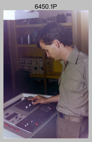 Bendigo Military Museum
Photograph - KLIMSCH Large Format Camera and Wild OR1 Orthorectification Equipment - Army Survey Regiment, Fortuna, Bendigo, c1986
The main tasks undertaken by technicians operating the KLIMSCH Commodore large format camera were enlargements and reductions of map reproduction material. seen in photo .1P is at the operating console. See item 6189.4P for more information and photos of CPL Whaling operating the KLIMSCH camera. Orthophoto mapping provided the Survey Corps with the capability to produce map products quickly in the event of a crisis. These are four photographs of equipment used by the Army Survey Regiment to produce orthophotomaps. The WILD OR1 orthophoto projector and workstation shown in photos .3P and .4P was introduced in the mid-1980s. It was the second-generation equipment used to orthorectify colour and monochrome film aerial photography, replacing the system introduced in 1973. See items 6124.5P and 6133.4P for more photographs of orthorectification equipment.These four photographs of KLIMSCH large format camera and Wild OR1 orthorectification equipment was taken at the Army Survey Regiment at Fortuna, Bendigo, c1986. The colour photographs are on 35mm negative film and scanned at 96 dpi. They are part of the Army Survey Regiment’s Collection. .1) - Photo, colour, c1986, CPL John Whaling operating the KLIMSCH Camera. .2) - Photo, colour, c1986, large format film developer. .3) - Photo, colour, c1986, WILD OR-1 Orthorectification Workstation operated by CPL Dave Jobe. .4) - Photo, colour, c1986, WILD OR-1 Orthorectification Workstation..1P to .4P – There are no annotations.royal australian survey corps, rasvy, army survey regiment, army svy regt, fortuna, asr -
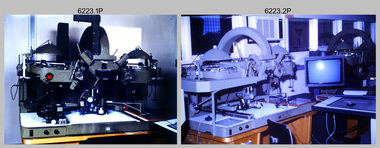 Bendigo Military Museum
Photograph - AUTOMAP 2 Production - Army Survey Regiment, Fortuna, Bendigo, c1986
This collection of 23 photos of map production on the AUTOMAP 2 computer-based system in Air Survey and Cartographic Squadrons, was most likely taken in 1986. The AUTOMAP 2 system was an upgrade to the AUTOMAP 1 system, comprising Intergraph graphic edit workstation terminals networked to VAX 750/785 main frame computers. Unlike AUTOMAP 1, operators could display digital topographic features on monitors for editing. Successful adaptation of this system meant RASvy was at the forefront of digital mapping/cartographic systems in Australia and overseas. The system comprised Input (Wild B8 Aviograph feature extraction) Raster Scanning (digitising from compilation sheets, Graphic Edit (cartographic completion) and Plot Verification Sub Systems. The system was operational from 1984 to its ‘Newheart’ upgrade in 1993. Throughout its life, the system was progressively refined with productivity gains, achieved from award winning technical development in-house by talented and innovative Army Survey Regiment personnel.This is a set of 23 photograph of AUTOMAP 2 production at the Army Survey Regiment at Fortuna, Bendigo, c1986. The photographs were on 35mm colour slides and were scanned at 96 dpi. Photos .5P and .6P are also printed on photographic and scanned at 300 dpi. They are part of the Army Survey Regiment’s Collection. .1) - Photo, colour, c1986, AUTOMAP 2 Production - Army Survey Regiment, Fortuna, Bendigo. c1986. .2) - Photo, colour, c1986, AUTOMAP 2 Wild B8 Aviograph stereoplotter. .3) - Photo, colour, c1986, AUTOMAP 2 Wild B8 Aviograph stereoplotter feature extraction, unidentified technician. .4) - Photo, colour, c1986, Wild B8 Aviograph stereoplotter feature extraction, LCPL Raelene (Munting) Brodie. .5) - Photo, colour, c1986, AUTOMAP 2 computer tape maintenance, SPR Steve Linane. .6) - Photo, colour, c1986, AUTOMAP 2 Graphic Edit Workstation, SPR Steve Linane. .7) to .8) - Photo, colour, c1986, AUTOMAP 2 Graphic Edit Workstation, unidentified technician. .9 to .10) - Photo, colour, c1986, AUTOMAP 2 Graphic Edit Workstation. .11) - Photo, colour, c1986, AUTOMAP 2 Graphic Edit Workstation feature coding and command menu. .12) - Photo, colour, c1986, AUTOMAP 2 high resolution computer monitor. .13) to .16) - Photo, colour, c1986, AUTOMAP 2 production output comparison to AUTOMAP 1. .17) to .18) - Photo, colour, c1986, AUTOMAP 2 computer system components. .19) - Photo, colour, c1986, AUTOMAP 2 Intergraph 7596 verification plotter. .20) - Photo, colour, c1986, AUTOMAP 2 Benson verification plotter, SPR Steve Coulson. .21) - Photo, colour, c1986, AUTOMAP 2 drainage, contour, roads and cultural digital data verification plot. .22) - Photo, colour, c1986, AUTOMAP 2 drainage, contour, roads and cultural digital data on computer monitor. .23) - Photo, colour, c1986, AUTOMAP 2 3D digital terrain model on computer monitor. .1P to .23P - Some of the equipment is annotated on the frame of the 35mm slides. .5P & .6P prints annotated incorrectly ‘Steve Lenane’. Correct spelling is - ‘Steve Linane’ royal australian survey corps, rasvy, army survey regiment, army svy regt, fortuna, asr, automap 2 -
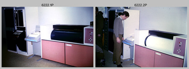 Bendigo Military Museum
Photograph - AUTOMAP 1 Production – Army Survey Regiment, Fortuna, Bendigo, c1978-1980
This collection of 17 photos was most likely taken in c1978-1980. The AUTOMAP 1 computer assisted cartography and mapping system was introduced in 1975. The components of AUTOMAP 1 were the Input Sub-System of four Wild B8s stereoplotters and three Gradicon digitising tables, the Optical Line Following Sub-System – Gerber OLF, the Verification Sub-System – Gerber 1442 drum plotter, the General Purpose Sub-system – HP21MX computer and the Output Sub-System – Gerber 1232 flatbed plotter). The first map was published in 1978 (Strickland 3665-3, 1:50,000). AUTOMAP 1 was the first computer assisted cartography and mapping system utilised by the Survey Corps and was the first system used by Australian mapping organisations. The history of the AUTOMAP 1 system is covered in more detail with additional historic photographs, in pages 116-118 of Valerie Lovejoy’s book 'Mapmakers of Fortuna – A history of the Army Survey Regiment’ ISBN: 0-646-42120-4. See items 6122.20P, 6410.24P, 6183.19P, 6184.20P, and 6200.5P for additional photographs of the AUTOMAP 1 system.This is a set of 17 photographs of Air Survey Squadron military and civilian personnel operating AUTOMAP 1 equipment at the Army Survey Regiment at Fortuna, Bendigo, c1978-1980. The photographs were on 35mm colour slides and were scanned at 96 dpi. They are part of the Army Survey Regiment’s Collection. .1) - Photo, colour, c1978-1980, Gerber 1442 verification drum plotter. .2) - Photo, colour, c1978-1980, Gerber 1442 verification drum plotter, SPR Garry Ames. In background - Hewlett Packard (HP) 2100A Minicomputer Input Subsystem controlling Wild B8 Aviograph stereo plotters. .3) - Photo, colour, c1978-1980, Gerber 1442 verification drum plotter. .4) - Photo, colour, c1978-1980, digitising topographic features with a Wild B8 Aviograph stereo plotter, CPL Adrian Rynberk. .5) to .6) - Photo, colour, c1978-1980, Wild PEB8 stereo profiler. .7) - Photo, colour, c1980, HP 9640A Programming System. .8) - Photo, colour, c1980, HP 9640A Programming System, L to R: unidentified, SGT Alan Toogood. .9) - Photo, colour, c1978-1980, Gerber Optical Line Follow (OLF), CAPT Rob Bridge. .10) - Photo, colour, c1978-1980, Gerber OLF. .11.) to .12) - Photo, colour, c1978-1980, Gerber OLF, SPR Gerry Gunn. .13) - Photo, colour, c1978-1980, Gerber OLF. .14) - Photo, colour, c1979, Gradicon edit table. .15) to .16) - Photo, colour, c1981, Gradicon edit table, SPR Chris Gordon. .17) - Photo, colour, c1981, Gradicon edit table, L to R: SPR Chris Brown, unidentified..1P to .17P - Some of the equipment is annotated on the frame of the 35mm slides.royal australian survey corps, rasvy, army survey regiment, army svy regt, fortuna, asr, automap 1 -
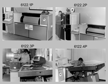 Bendigo Military Museum
photograph - AUTOMAP 1 Production – Army Survey Regiment, Fortuna, Bendigo, c1980
This collection of 20 photos was most likely taken in 1980. The AUTOMAP 1 computer assisted cartography and mapping system was introduced in 1975. The components of AUTOMAP 1 were the Input Sub-System of four Wild B8s stereoplotters and three Gradicon digitising tables, the Optical Line Following Sub-System – Gerber OLF, the Verification Sub-System – Gerber 1442 drum plotter, the General Purpose Sub-system – HP21MX computer and the Output Sub-System – Gerber 1232 flatbed plotter). The first map was published in 1978 (Strickland 3665-3, 1:50,000). AUTOMAP 1 was the first computer assisted cartography and mapping system utilised by the Survey Corps and was the first system used by Australian mapping organisations. The history of the AUTOMAP 1 system is covered in more detail with additional historic photographs, in pages 116-118 of Valerie Lovejoy’s book 'Mapmakers of Fortuna – A history of the Army Survey Regiment’ ISBN: 0-646-42120-4. See items 6410.24P, 6183.19P, 6184.20P, 6200.5P, and 6222.17P for additional photographs of the AUTOMAP 1 system.This is a set of 20 photographs of Air Survey Squadron military and civilian personnel operating AUTOMAP 1 equipment at the Army Survey Regiment at Fortuna, Bendigo, c1980. The photographs were on 35mm negative film and were scanned at 96 dpi. They are part of the Army Survey Regiment’s Collection. Photos .19P and .20P are printed on photographic and scanned at 300 dpi. .1) - Photo, black & white, c1980, Gerber plotter. .2) - Photo, black & white, c1980, Gerber plotter, LT Rob John .3) - Photo, black & white, c1980, Gradicon edit table, SPR Jamie McRae .4) - Photo, black & white, c1980, Gradicon edit table, SPR Steve Linane .5) - Photo, black & white, c1980, 1130 System administration, unidentified. .6) - Photo, black & white, c1980, Wild B8 stereo plotter, SPR Van Dalen? .7) - Photo, black & white, c1980, Wild B8 stereo plotter, SPR Van Dalen? .8) - Photo, black & white, c1980, Gerber Optical Line Follower (OLF). .9) - Photo, black & white, c1980, Gerber OLF. .10) - Photo, black & white, c1980, Gerber OLF. .11) - Photo, black & white, c1980, Gerber OLF. .12) - Photo, black & white, c1980, Gerber OLF. .13) - Photo, black & white, c1980, Data management, CPL Greg Gilbert. .14) - Photo, black & white, c1980, Data management, CPL Greg Gilbert. .15) - Photo, black & white, c1980, 1130 Operating System administration, SGT Denis Marshall. .16) - Photo, black & white, c1980, Programming System, L to R: unidentified, SGT Alan Toogood. .17) - Photo, black & white, c1980, Programming System, L to R: Robert Cox, WO1 Bob Mason, John Dean. .18) - Photo, black & white, c1980, Programming System, L to R: Robert Cox, WO1 Bob Mason, John Dean. .19) - Photo, black & white, c1980, Gradicon edit table, CPL Chris Carter. .20) - Photo, black & white, c1980, Gerber plotter, LT Rob John..1P to .18P - No personnel are identified .19P - ‘CPL Chris Carter’ annotated on backroyal australian survey corps, rasvy, army survey regiment, army svy regt, fortuna, asr, air survey, automap