Showing 516 items
matching panorama
-
 Ballaarat Mechanics' Institute (BMI Ballarat)
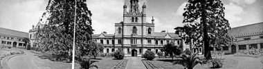
Benevolent Asylum Panorama
This photograph is from the Max Harris Collection held by the Ballaraat Mechanics' Institute. Please contact BMI for all print and usage inquiries.ballarat, benevolent home, panorama -
 Ballaarat Mechanics' Institute (BMI Ballarat)
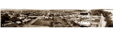
Lake Panorama 1
This photograph is from the Max Harris Collection held by the Ballaraat Mechanics' Institute. Please contact BMI for all print and usage inquiries.ballarat, lake wendouree, panorama -
 Ballaarat Mechanics' Institute (BMI Ballarat)
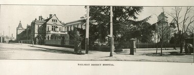
Panorama Ballarat District Hospital
This photograph is from the Max Harris Collection held by the Ballaraat Mechanics' Institute. Please contact BMI for all print and usage inquiries.ballarat, district hospital, panorama -
 Ballaarat Mechanics' Institute (BMI Ballarat)
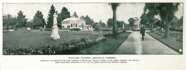
Panorama Statuary Pavilion, Ballarat Botanical Gardens
This photograph is from the Max Harris Collection held by the Ballaraat Mechanics' Institute. Please contact BMI for all print and usage inquiries.ballarat, statuary pavillion botanical gardens, panorama -
 Stawell Historical Society Inc
Photograph, St. Patrick’s Catholic Church
St. Patrick’s Catholic Church and surrounding buildings 1880's. The church was opened in 1873. The construction is of Black Ranges faced with Grampians Freestone. The bell tower is 70 feet high, and the walls are 30 inches thick. The church was opened on 30th March 1873 by the Bishop of Melbourne, the Right Reverend Dr. Goold. The Historical Society have a programme for this opening - tickets for front seats were 10/- each. The sanctuary was added during 1927 as was a white marble altar which was the gift of a parishioner. Much earlier - In 1865 - a wooden Catholic Church was built on this street near the Court House site. The wooden building became too small for the congregation and this church was commenced before the end of 1869. Sepia photograph of St Patrick's Catholic Church and surrounding buildings. The photo also shows mining operations in Stawell with the Grampians in the background c 1880's. Two enlargements of the Catholic Church are taken from the sepia photograph and marked as 105a.C. Herbert. Photo. Copyright Registered Stawell. on the back is written "Stawell from Big Hill c 1880" stawell, panorama, mining -
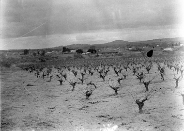 Stawell Historical Society Inc
Photograph, View of Great Western, early 1900's
Digital Photo taken from glass slide by Geoff McMillan, Cooper Street Stawell and reproduced as a photo - printed at Stawell Historical Society 2019Black & White Photo - a view from Western View Road, Great Western, looking west over Great Western itself - the back of the Great Western Hall, hotel etc. St Peter's vineyard building near the top right. winery, wine making, panorama -
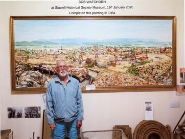 Stawell Historical Society Inc
Photograph, Mr Bob Watchorn with his Painting of Stawell
Completed in 1984 by Bob Watchorn gold, mining, panorama -
 Stawell Historical Society Inc
Photograph, Davis Open Cut West Wall North End
Photo of Stripping 1987mining, gold, panorama -
Stawell Historical Society Inc
Photograph, Davis Open Cut 24/28 meter South Wall 1987
mining, gold, panorama -
Stawell Historical Society Inc
Photograph, Davis Open Cut 1987
mining, gold, panorama -
Stawell Historical Society Inc
Photograph, Davis Open Cut East Wall North End 1988
mining, gold, panorama -
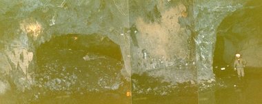 Stawell Historical Society Inc
Photograph, Stawell Gold Mine, Stawell Gold Mine Drives Underground 1988
Workers standing in Stawell Gold Mine Underground Drives. One Drive showing rock backfillpanorama, gold, mining -
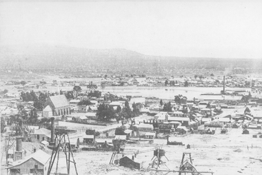
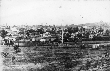
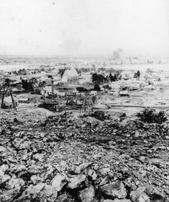 Stawell Historical Society Inc
Photograph, St Patrick's Church and surrounds from Big Hill with mining activity in foreground
St. Patrick’s Catholic Church and surrounding buildings 1880's. Poppet heads can be seen in the foreground and mining spoil around Big Hill. Behind the church is the Poppet Head of No4 North Scotchmans. The Poppet Head at the left of the photo is No1 & No2 North Scotchmans which joined with the Stawell Amalgamated Scotchmans Company in 1887. Early view of St Patrick's Catholic Church and surrounds from Big Hill. Mining works and spoil in the forground. stawell, panorama, mining -
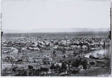 Stawell Historical Society Inc
Photograph, View of Stawell from Big Hill April 1874 showing mines centered on north end of Main Street -- 2 Photos
From left Shire Hall Pleasant Creek in distance, Mathers & Franklin, Stawell Coach Factory, Coffee Palace, Christ Church of England Church Hill, Mechanics Institute, Temperance Hotel, Matherson Cross Reef Hotel.Black and White Holtermann photograph of Stawell from Big Hill with mining in foreground. 1874 Site of fire in Main and Street Patrick Street 22 April 1874 visible in centre of photograph.mining, panorama, streetscape -
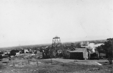 Stawell Historical Society Inc
Photograph, Sloanes & Scotchmans Mine
Poppet Head and Engine House of Sloane & Scotchmans United Mine taken from Big Hill Facing North West. c 1915 to 1920mining, panorama, gold -
 Ballarat Heritage Services
Photograph - Photograph - Colour, L.J. Gervasoni, Daylesford, 1987, c1987
Daylesford is a Central Victorian town.Three colour photographs placed together to make a panoramic view of Daylesford, Victoriadaylesford, spa country, panorama -
 Stawell Historical Society Inc
Photograph, Town & Big Hill from King Street area c1900
Town & Big Hill from King Street area. c1900 Market Building in Skene Street visible in left of photo. St Patrick's Church on Right. Rail line and signal pole in foreground of photo across image.stawell, streetscape, panorama -
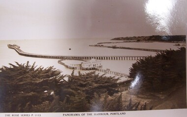 Glenelg Shire Council Cultural Collection
Postcard - Postcard - Panorama of Portland Harbour, n.d
Black and white photographic image of a harbour with two long piers running into it and a shorter jetty with a building on it and circular jetty protruding from it. In the foreground are trees, a dirt road to the foreground right and a railway track visible between the trees.Front: THE ROSE SERIES P. 1113/ COPYRIGHT (typed, lower left) PANORAMA OF THE HARBOUR, PORTLAND (typed, lower centre) Back: (no incriptions) -
 Bendigo Historical Society Inc.
Photograph - BENDIGO PHOTO FOLDER
Gray covered photo folder, includes photos of Rosalind Park, Lake Weeroona boatsheds, conservatory, Pall Mall, Queens Gardens, lookout poppet head, panorama frog m lookout tower, Bendigo.Early 1900'splace, bendigo, view of bendigo -
 Greensborough Historical Society
Book, Shire of Diamond Valley Community Handbook 1991, 1991_
Guide to services provided by Shire of Diamond Valley. The Shire of Diamond Valley was a Local Government Area located about 20 kilometres northeast of Melbourne. The shire covered an area of 74.38 square kilometres and existed from 1964 until 1994.Annual guide to services in Shire of Diamond Valley36 pages, col illus., maps. Front cover is a collage of scenes from Diamond Valley, back cover illustration of a copy of "Summer Panorama, Tabletop, NSW" by Max Dimmack, from the Shire of Diamond Valley Art Collection.shire of diamond valley, greensborough, handbooks -
 Greensborough Historical Society
Book, Shire of Diamond Valley, Shire of Diamond Valley Community Handbook 1991, 1991_
Guide to services provided by Shire of Diamond Valley. The Shire of Diamond Valley was a Local Government Area located about 20 kilometres northeast of Melbourne. The shire covered an area of 74.38 square kilometres and existed from 1964 until 1994.Annual guide to services in Shire of Diamond Valley36 pages, col. illus., maps. Front cover is a collage of scenes from Diamond Valley, back cover illustration of a copy of "Summer Panorama, Tabletop, NSW" by Max Dimmack, from the Shire of Diamond Valley Art Collection.shire of diamond valley -
Port Melbourne Historical & Preservation Society
Photograph - Beach Street, Port Melbourne, Alison Kelly, c. 1990
One of four photographs of Beach Street from Station to Princes Pier taken by Alison Kelly from the roof of the Missions to Seamen building. The four make up a panoramic view of the foreshore, .07 being an outer section of the panoramapiers and wharves - princes pier, alison kelly -
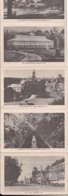
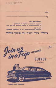 Clunes Museum
Photograph
PICTURESQUE SOUVENIR OF CLUNES. A FOLDER OF 8 PHOTOS CONSISTING OF VIEWS OF CLUNES 1. 4 PANORAMAS 2. CLUNES HOSPITAL 3. OLD POST OFFICE 4. TALLAROOP RIVER CLUNES 5. 2 OF FRASER STREET, CLUNESJOIN US IN A TRIP AROUND CLUNESlocal history, photography, photographs, township & buildings -
Clunes Museum
Photograph - PHOTOGRAPHY, PUBLISHED BY E. BARNETT, SNAPSHOTS OF CLUNES
THE PHOTOGRAPHS ARE; SOLDIERS MONUMENT, PORT PHILIP GOLD MINE, TULAROOP CREEK, TOWN HALL, PANORAMA, QUEEN'S WALK, BRIDGE, POST OFFICE,&TOWN HALL,STATE SCHOOL.9 FOLD OUT SNAP SHOTS OF CLUNES, PRESENTED IN FOLDERlocal history, photography, photographs, clunes township -
Port Melbourne Historical & Preservation Society
Magazine - Periodical, Port of Melbourne Panorama, 1988 - 1991
Six (6) copies of Port of Melbourne Panorama 1988-91 .01 - April 1988; .02 June 1988 ; .03 December 1988 ; .04 April/May 1989; .05 August/September 1989; .06 Third quarter 1991transport - shipping, maritime, melbourne harbor trust - port of melbourne authority -
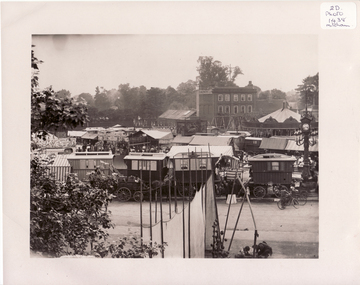 Whitehorse Historical Society Inc.
Photograph, Mitcham, Surrey England, 1900
Black and white photo of Mitcham Fair on Fair Green by Thos. Francis, London House, Mitcham, England. 1900. The photo overlaps and give a panorama of the Fair as far as could been seen from Ravensbury House (J.D.Drewett). See NP1438mitcham, england -
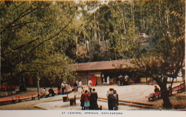 Ballarat Heritage Services
Souvenir - Postcard Booklet Image, Nucolor Vue, A Souvenir of Beautiful Daylesford, c1948
Daylesford in a tourist town with natural mineral water springsA booklet of colour images depicting 12 scenes of Daylesford, Victoria. The front cover is decorated with an illustration of a dirt road with sign post. Images include: Panorama over Daylesford, from lookout tower Panorama over Lake Daylesford Pioneer Memorial Lookout Tower, Daylesford Near the swimming pool, Lake Daylesford Botanical Gardens, Daylesford Vincent Street, showing Town Hall, Daylesford Vincent Street, Daylesford Glimpse of lovely Jubilee Lake, Daylesford Central Springs, Daylesford Sutton Springs, Daylesford Corner of the beautiful Botanical Gardens, Daylesford Loddon Falls, near Daylesford.daylesford, jubillee lake, wombat hill, vincent street, sutton springs, central springs, loddon springs, pioneer lookout, pioneer memorial lookout, loddon falls, lake daylesford -
Clunes Museum
Newspaper - NEWSPAPER /CUTTING, 1933
IT SHOWS THE FOUNTAIN IN THE GARDEN, SHIRE HALL, MAIN STREET FROM THE WEST, THE SHOPPING CENTRE, THE STATE SCHOOL PANORAMA, THE STATE SCHOOL SCHOLARS. A CORNER OF THE TOWN. WAR MEMORIAL, GOLD DISCOVERY MONUMENT. E.SA BANK & A PRETTY STRETCH OF THE CREEK, KNITTING MILL.local history, document, newspaper cutting, weickhardt family -
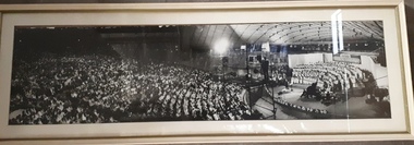 Vision Australia
Photograph - Image, Carols by Candlelight audience, crew and stage
Framed black and white panorama photograph of the crowd and stage at Carols by Candlelight. A choir master conducts a large choir, whilst the audience listen appreciatively and television cameras capture the event from platforms above the audience4 B/W photographs aligned to create panaromacarols by candlelight, marketing -
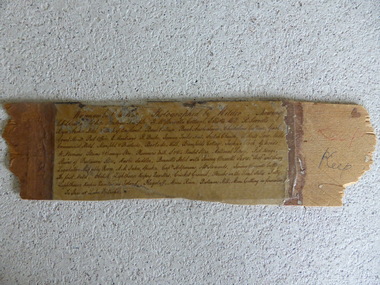 Warrnambool and District Historical Society Inc.
Frame Fragment, Frame Fragment from 1860 J Wilder, Late 19th century
Joseph Wilder, a professional photographer, came to Warrnambool in 1860 and took a series of photographs, two of which survive today. One was of the local Volunteer Corps and the other was a series of photographs taken from Cannon Hill showing Merri Street and the town and buildings beyond. It seems that copies of these last-mentioned photographs were framed to produce a large panoramic view of 1860 Warrnambool and one of these was given to the old Warrnambool Museum in the 1880s by James Astley Bromfield. He had established a chemist’s shop in Warrnambool in 1854 and showed his interest in the history of the young town by producing a map in 1856 showing the first landowners, a seminal resource today for historians. He again demonstrated this interest when he included the names of the people and places in the 1860 photograph he gave to the museum in the 1880s. The frame fragment was found amongst the collection of items from the old Museum at Flagstaff Hill Maritime Museum and brought to the Historical Society to accompany the original series of photographs. Bromfield went to live in Melbourne in the 1880s. It is presumed that the plastic cover has been placed on the frame fragment at a much later date than the 1880s.This frame fragment is interesting and very important for several reasons:- 1. It is one demonstration of the interest that James Astley Bromfield had in local history 2. It came from the old Warrnambool Museum and shows how that institution kept items of historical interest 3. It gives us the names of the people and places in the Joseph Wilder photographs of 1860 that placed together form a panorama that reveals what a major section of Warrnambool looked like only 13 years after its foundation. The list enables us to correctly identify the early places and people and so is invaluable for research purposes 4. It links a Museum exhibit of the 1880s with the original 1860 photographs which are held by the Historical Society This is a piece of wood broken from a frame containing a photograph. It has jagged edges. It contains the list of people and places depicted in the Joseph Wilder panorama photograph of Warrnambool in 1860. The list is handwritten in ink on paper which has been attached to the frame with a piece of plastic. Warrnambool in 1860 Photographed by Wilder. Showing children of the late Andrew Semple etc In red pencil – ‘Keep’, in ink, ‘Keep’ On separate piece of paper - Presented to Warrnambool Mechanics’ Muzeum by James Astley Bromfield, August 3rd 1886 joseph wilder 1860, panorama of warrnambool