Showing 9791 items matching " plenty road"
-
 Eltham District Historical Society Inc
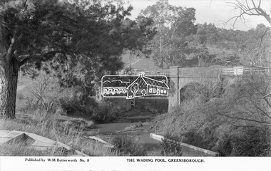
Photograph, The Rose Stereograph Company, The Wading Pool, Greensborough, c.1939
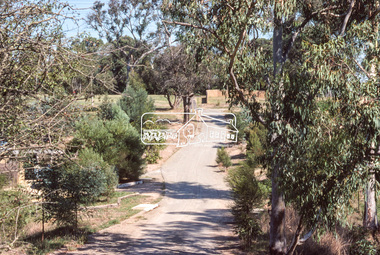
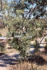
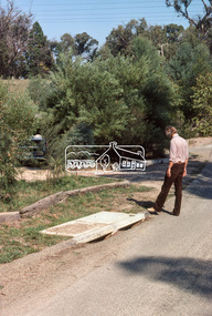
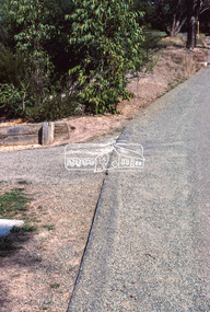
... greensborough bridge main road plenty river w. m. butterworth pioneer ...View looking northeast across the wading pool set into the Plenty River towards the original bluestone Greensborough Bridge (since demolished). A timber pedestrian footbridge added after construction is visible on the far side of the bridge through the arch and beyond to the hillside which is now present day Pioneer Reserve. This glass plate negative was used to manufacture postcards (1:1 printing) for commercial sale by the Rose Sterograph Company and its subsidiaries. George Rose founded the Rose Stereograph Company in 1880 and was joined by Herbert (Bert) Cutts in the early 20th Century. The pair formed a lifetime working partnership and strong personal friendship. Assisted by George’s two sons, Herbert George and Walter, and later by Neil Cutts, the Rose Stereograph Company continued its operations for more than 140 years. The company was initially built on stereographs, but as cinema took over and stereographs fell out of fashion, the Rose Stereograph Company developed Australia’s first commercially viable photographic postcard business. Specialising in postcards of iconic historical moments and significant landmarks, The Rose Stereograph Company became a staple of the Australian travel industry.This remarkable collection of glass plate negatives, transparencies, and postcards – arguably Australia’s most significant photography collection outside of public hands – has been passed down through the generations, surviving war, relocation, and the harsh Victorian climate. The historic Rose Stereograph collection is the culmination of George Rose’s dream of capturing and preserving precious moments in time and remains the legacy of the Rose and Cutts families. It is with great sadness that the Cutts family says goodbye to a collection that spans five generations and 140 years. The Cutts family understands that for these historically important pieces to rest with one family is to deny others the pleasure of their custodianship.Glass Plate Negative Size: 9.1 x 14 cmThe Wading Pool, Greensborough, Published by W. M. Butterworh No. 8postcard, travel, rose stereograph company, glass plate negative, greensborough, footbridge, greensborough bridge, main road, plenty river, w. m. butterworth, pioneer reserve, wading pool, peter and elizabeth pidgeon collection -
 Eltham District Historical Society Inc
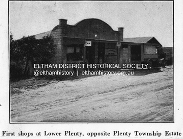
Negative - Photograph, Coghill & Haughton, First shops at Lower Plenty opposite Plenty Township Estate, c.1924
... Sales Brochure: Plenty Township Estate and Bryn Teg Hill's ...Negative copy and associated print of detail from original Sales Brochure: Plenty Township Estate and Bryn Teg Hill's Estate, Coghill & Haughton, Melbourne (c.1924)Roll of 35mm Black and White negative film, 3 strips, (1 of 14 frames) Print 10 x 15 cmFilm - Agfa Ortho 25lower plenty, bryn teg hill's estate, coghill & haughton, sales brochure, main road, plenty-township-estate, shops -
 Eltham District Historical Society Inc
Document (Item) - Article, The Eltham Roll of Honour: Second World War, 9 Aug 2020
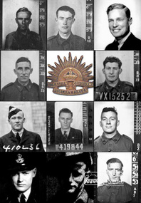
... lower plenty old eltham road royal australian engineers vx10044 ...Information regarding the circumstances of the eleven men of the Shire of Eltham who died serving their country in the Second World War and for whom the Eltham War Memorial was dedicated. Their names are listed on the Eltham Roll of Honour in order of rank. The image portrayed shows the eleven men (left to right, top to bottom) by date of fatality: CASTLEDINE, George Ernest, Spr., VX10044 (KIA 18 Apr 1941, Greece) GAHAN, Studley Manston, Capt., VX48379 (KIA 17 May 1941, Tobruk, Libya) RUTTER, David, Flying Off., 833 (400833) (KIA 9 Dec 1941, Bir El Gubbi, Libya) CLERKE, Alfred Charles, Cpl., VX23112 (KIA 2 Feb 1942, Laha, Ambon Island) DUNLOP, Cuthbert Douglas, Sgt., VX15252 (KIA 22 Nov 1942, Gona, New Guinea) INGRAM, Lester Neil, Flt. Sgt., 410236 (DOD 22 Apr 1943, Longworth, England) McLEAN, Stanley, Flt. Sgt., 419844 (KIA 7 Oct 1944, Emmerich, Germany) FELDBAUER, Theodore, Sgt., VX51733 (DOD 27 Mar 1945, Borneo) RUTTER, Donald Hemphill, Flt. Lt., 410262 (KIA 5 Apr 1945, Varrelbusch, Germany) FIELD, Kevin Francis, Pte., VX144763 (KIA 28 Jun 1945, Bougainville, PNG) BUTHERWAY, Jack Herbert, Pte, VX37645 (DOD 8 Jul 1945, Borneo)eltham war memorial, roll of honour, second world war, eltham, eltham roll of honour, shire of eltham, 2/4 field workshop, 22 independent brigade group ordnance workshop, a.i.f., australian army ordnance corps, australian corps of electrical and mechanical engineers, changi, falkiner street, florence mary butherway, jack herbert butherway, prisoner of war (pow), ranau number 1 jungle camp, sandakan death march, singapore, thomas james butherway, vx37645, 2/2 field company, 6th division, abington, annie castledine, arthur frederick castledine, george ernest castledine, greece, jean simonson, lower plenty, old eltham road, royal australian engineers, vx10044 sapper g. e. castledine, 2/23 bn, derril, gahan house, main road, rats of tobruk, studley manston gahan, tobruk, vx48379, 3 squadron r.a.a.f., aboukir, alamein memorial, beulah alice (simpson) rutter, bir el gubbi, broken hill aero club, david rutter, egypt, hubert rutter, libya, yarra braes, 2/21 bn, 23rd australian infrantry brigade, 8th division, alfred charles clerke, ambon island, battle of ambon, bidgeland park estate, inga caroline (nicholls) clerke, inga mary nicholls, laha airfield, nora ann clerke, rose matilda clerke, vx23112, william charles clerke, 2/14 bn, 2/16 bn, 21st brigade, 7th division, cuthbert douglas dunlop, gona, gona war cemetery, henry street, janet dunlop, kokoda track, new guinea, palestine, papua new guinea, port moresby (bomana) war cemetery, reuben cuthbert dunlop, syria, vx15252, 10 operational training unit, 410236, ada (key) ingram, berkshire, bomber command, england, group no. 91, john ingram, lester neil ingram, longworth, n.1374, r.a.a.f., r.a.f., r.a.f. abington, research (vic.), whitley v bomber, 419844, 514 bomber squadron, emmerich, germany, gordon stanley mclean, ji-g2, kleve, lancaster lm735, lucy mclean, mount pleasant road, r.a.f. waterbeach, reichswald forest war cemetery, stanley mclean, 2/10 ordnance workshops, albert feldbauer, eltham cricket association, eltham girls club, frank street, henry feldbauer, jessie margarette feldbauer, june feldbauer, ken ingram, margaret (feldbauer) ingram, montmorency imperials, research cricket club, research state school, sandakan number 1 camp, sandakan number 2 camp, theodore albert feldbauer, valerie (feldbauer) waller, violet amelda (teagle) feldbauer, vx51733, 247 ‘china-british’ squadron, caithness, cloppenburg, donlad hemphill rutter, essen, gloucester, hanover war cemetery, hanover-limmer british military cemetery, holten-lochem, oldenburg, r.a.f. castletown, r.a.f. station lealing, stoppenburg, typhoon ib jp443, typhoon ib sw526, 15th australian infantry brigade, 1940 cup, 3rd division, 57th/60th bn, best and fairest, bougainville island, buin road, mary field, mayona road, mivo river, mobiai river, montmorency, vx144763, william field -
 Eltham District Historical Society Inc
Photograph, Width and stand of construction, Riverhill Drive, Lower Plenty, c.March 1981, 1981
... infrastructure, lower plenty, riverhill drive, road... infrastructure, lower plenty, riverhill drive, road construction, streets ...Infrastructure features used by Eltham Shire Council in the construction of Riverhill Drive, Lower Plenty, c.March 198135mm colour positive transparency Kodak Kodachrome cardboard mount Also Kodak Enlargement of slide 27 x 35.5 cminfrastructure, lower plenty, riverhill drive, road construction, streets -
 Eltham District Historical Society Inc
Photograph, Curvilinear design, Riverhill Drive, Lower Plenty, c.March 1981, 1981
... infrastructure, lower plenty, riverhill drive, road... infrastructure, lower plenty, riverhill drive, road construction, streets ...Infrastructure features used by Eltham Shire Council in the construction of Riverhill Drive, Lower Plenty, c.March 198135mm colour positive transparency Kodak Kodachrome cardboard mountinfrastructure, lower plenty, riverhill drive, road construction, streets -
 Eltham District Historical Society Inc
Photograph, Vegetation, Riverhill Drive, Lower Plenty, c.March 1981, 1981
... infrastructure, lower plenty, riverhill drive, road... infrastructure, lower plenty, riverhill drive, road construction, streets ...Infrastructure features used by Eltham Shire Council in the construction of Riverhill Drive, Lower Plenty, c.March 198135mm colour positive transparency Kodak Kodachrome cardboard mountinfrastructure, lower plenty, riverhill drive, road construction, streets -
 Eltham District Historical Society Inc
Photograph, Water drainage pits with double side entry, Riverhill Drive, Lower Plenty, c.March 1981, 1981
... infrastructure, lower plenty, riverhill drive, road... infrastructure, lower plenty, riverhill drive, road construction, streets ...Infrastructure features used by Eltham Shire Council in the construction of Riverhill Drive, Lower Plenty, c.March 198135mm colour positive transparency Kodak Kodachrome cardboard mountinfrastructure, lower plenty, riverhill drive, road construction, streets -
 Eltham District Historical Society Inc
Photograph, Rollover kerb sprayed and Lilydale topped, Riverhill Drive, Lower Plenty, c.March 1981, 1981
... infrastructure, lower plenty, riverhill drive, road... infrastructure, lower plenty, riverhill drive, road construction, streets ...Infrastructure features used by Eltham Shire Council in the construction of Riverhill Drive, Lower Plenty, c.March 198135mm colour positive transparency Kodak Kodachrome cardboard mountinfrastructure, lower plenty, riverhill drive, road construction, streets -
 Eltham District Historical Society Inc
Photograph, Lilydale topping on final surface, Riverhill Drive, Lower Plenty, c.March 1981, 1981
... infrastructure, lower plenty, riverhill drive, road... infrastructure, lower plenty, riverhill drive, road construction, streets ...Infrastructure features used by Eltham Shire Council in the construction of Riverhill Drive, Lower Plenty, c.March 198135mm colour positive transparency Kodak Kodachrome cardboard mountinfrastructure, lower plenty, riverhill drive, road construction, streets -
 Eltham District Historical Society Inc
Photograph, Curvilinear design, Riverhill Drive, Lower Plenty, c.March 1981, 1981
... infrastructure, lower plenty, riverhill drive, road... infrastructure, lower plenty, riverhill drive, road construction, streets ...Infrastructure features used by Eltham Shire Council in the construction of Riverhill Drive, Lower Plenty, c.March 198135mm colour positive transparency Kodak Kodachrome cardboard mountinfrastructure, lower plenty, riverhill drive, road construction, streets -
 Eltham District Historical Society Inc
Photograph, Rollover kerb sprayed and Lilydale topped, Riverhill Drive, Lower Plenty, c.March 1981, 1981
... infrastructure, lower plenty, riverhill drive, road... infrastructure, lower plenty, riverhill drive, road construction, streets ...Infrastructure features used by Eltham Shire Council in the construction of Riverhill Drive, Lower Plenty, c.March 198135mm colour positive transparency Kodak Kodachrome cardboard mountinfrastructure, lower plenty, riverhill drive, road construction, streets -
 Eltham District Historical Society Inc
Photograph, T-bowl and extended drive, Riverhill Drive, Lower Plenty, c.March 1981, 1981
... infrastructure, lower plenty, riverhill drive, road... infrastructure, lower plenty, riverhill drive, road construction, streets ...Infrastructure features used by Eltham Shire Council in the construction of Riverhill Drive, Lower Plenty, c.March 198135mm colour positive transparency Kodak Kodachrome cardboard mountinfrastructure, lower plenty, riverhill drive, road construction, streets -
 Eltham District Historical Society Inc
Photograph, Rollover kerb sprayed and Lilydale topped, Riverhill Drive, Lower Plenty, c.March 1981, 1981
... infrastructure, lower plenty, riverhill drive, road... infrastructure, lower plenty, riverhill drive, road construction, streets ...Infrastructure features used by Eltham Shire Council in the construction of Riverhill Drive, Lower Plenty, c.March 198135mm colour positive transparency Kodak Kodachrome cardboard mountinfrastructure, lower plenty, riverhill drive, road construction, streets -
 Eltham District Historical Society Inc
Photograph, T-bowl, Riverhill Drive, Lower Plenty, c.March 1981, 1981
... infrastructure, lower plenty, riverhill drive, road... infrastructure, lower plenty, riverhill drive, road construction, streets ...Infrastructure features used by Eltham Shire Council in the construction of Riverhill Drive, Lower Plenty, c.March 198135mm colour positive transparency Kodak Kodachrome cardboard mountinfrastructure, lower plenty, riverhill drive, road construction, streets -
 Eltham District Historical Society Inc
Photograph, General view, Riverhill Drive, Lower Plenty, c.March 1981, 1981
... infrastructure, lower plenty, riverhill drive, road... infrastructure, lower plenty, riverhill drive, road construction, streets ...Infrastructure features used by Eltham Shire Council in the construction of Riverhill Drive, Lower Plenty, c.March 198135mm colour positive transparency Kodak Kodachrome cardboard mountinfrastructure, lower plenty, riverhill drive, road construction, streets -
 Eltham District Historical Society Inc
Photograph, General view of Riverhill Drive showing pits, Lower Plenty, c.March 1981, 1981
... infrastructure, lower plenty, riverhill drive, road... infrastructure, lower plenty, riverhill drive, road construction, streets ...Infrastructure features used by Eltham Shire Council in the construction of Riverhill Drive, Lower Plenty, c.March 198135mm colour positive transparency Kodak Kodachrome cardboard mountinfrastructure, lower plenty, riverhill drive, road construction, streets -
 Eltham District Historical Society Inc
Photograph, Water drainage pits at low point, Riverhill Drive, Lower Plenty, c.March 1981, 1981
... infrastructure, lower plenty, riverhill drive, road... infrastructure, lower plenty, riverhill drive, road construction, streets ...Infrastructure features used by Eltham Shire Council in the construction of Riverhill Drive, Lower Plenty, c.March 198135mm colour positive transparency Kodak Kodachrome cardboard mount Also Kodak Enlargement of slide 27 x 35.5 cminfrastructure, lower plenty, riverhill drive, road construction, streets -
 Eltham District Historical Society Inc
Photograph, Driveway detail, Riverhill Drive, Lower Plenty, c.March 1981, 1981
... infrastructure, lower plenty, riverhill drive, road... infrastructure, lower plenty, riverhill drive, road construction, streets ...Infrastructure features used by Eltham Shire Council in the construction of Riverhill Drive, Lower Plenty, c.March 198135mm colour positive transparency Kodak Kodachrome cardboard mountinfrastructure, lower plenty, riverhill drive, road construction, streets -
 Eltham District Historical Society Inc
Photograph, Driveway detail, Riverhill Drive, Lower Plenty, c.March 1981, 1981
... infrastructure, lower plenty, riverhill drive, road... infrastructure, lower plenty, riverhill drive, road construction, streets ...Infrastructure features used by Eltham Shire Council in the construction of Riverhill Drive, Lower Plenty, c.March 198135mm colour positive transparency Kodak Kodachrome cardboard mountinfrastructure, lower plenty, riverhill drive, road construction, streets -
 Greensborough Historical Society
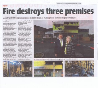
Newspaper Clipping, Diamond Valley Leader, Fire destroys three premises, 28/11/2018
... . plenty fire ray white plenty diamond creek road greensborough ...Investigators are still trying to determine what sparked a fire that tore through three Plenty businesses on November 17, as staff described their narrow escape.News article 1 page, black text and colour image .plenty fire, ray white plenty, diamond creek road greensborough -
 Greensborough Historical Society
Plan, Plan of Manatunga Circuit Greensborough subdivision, 1970_
... creek road plenty river drive Various handwritten comments ...Plan of Manatunga Circuit subdivision. Prepared by O'Connor and Beveridge (land surveyors) for Development Underwriting (developers). Plan of subdivision. Part of Crown Portion 3. Parish of Nillumbik, County of Evelyn.An original example of a subdivision plan in the expanding suburb of Greensborough. The 1960s and 1970s saw this area develop from a rural farming area to a suburb.Plan of subdivision. Printed on buff paper, hand coloured. Mounted on cardboard. Includes 2 small cards attached.Various handwritten comments. Small cards from Survey Branch, Office of Titles.greensborough, manatunga circuit, diamond creek road, plenty river drive -
 Eltham District Historical Society Inc
Photograph, Para Road, Montmorency, industrial area looking south from Plenty River Bridge on boundary of Shire of Eltham
... road plenty river industry Colour photograph Para Road ...Colour photograph02076, montmorency (france) photo album, montmorency, para road, plenty river, industry -
 Eltham District Historical Society Inc
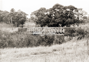
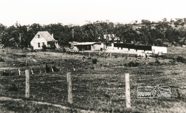
Photograph, Old Lower Plenty Bridge, c.1970
... collections as well as several recent views. main road plenty river ...Old bridge across the Plenty River at Lower Plenty now part of the Plenty River Trail. Part of a slide show presentation "Bridges & Waterways of the Shire" by Russell Yeoman to the 13 September 1989 Society meeting. The presentation included slides of historic photos from the Shire of Eltham Pioneers collections as well as several recent views.Black and white photographmain road, plenty river, bridge, lower plenty, plenty river trail -
 Eltham District Historical Society Inc
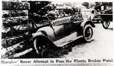
Photograph, Moral - "Never attempt to pass the Plenty Bridge Hotel"
... melbourne lower plenty bridge main road lower plenty bridge ...Black and white photograph of a newspaper story about an accident at Lower Plenty Bridgelower plenty, bridge, main road, lower plenty bridge, transport, automobile, accident -
 Melbourne Tram Museum
Photograph - Set of two Black & White Photograph/s, Metropolitan Transit Authority (MTA), 10/01/1985 12:00:00 AM
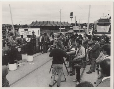
... in pencil "Vic Premier Mr. J. Cain opening second stage of Plenty... Premier Mr. J. Cain opening second stage of Plenty Road tram ...Set of two Black and White Photographs of the opening of the Bundoora to La Trobe University extension 10 January 1985 by the Premier of Victoria, Mr John Cain. .1 - Has the Premier speaking with a small audience and many TV reporters crews etc. Has the McDonalds in the background. .2 - The Premier cutting the ribbon with a Z class tram behind. See Reg Item 438 for a use of this photograph and Reg Item 5155 for other photographs.1 - On the rear in ink - "10 Jan 1985 Bolderwood Parade "opening" (Prior to moving along stage two)." .2 - on the rear in pencil "Vic Premier Mr. J. Cain opening second stage of Plenty Road tram extension 10 January 1985 MTA Photo" and "Please return to JRP by 1/4/85".trams, tramways, opening, la trobe university, bundoora -
 Greensborough Historical Society
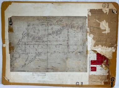
Poster - Planning Document, Shire of Diamond Valley, Subdivision Plan # G 1, Watsonia, 1962 and 1976
... : subdivision of LP5406 bounded by Plenty Road, Greensborough Road...: subdivision of LP5406 bounded by Plenty Road, Greensborough Road ...Plan of Subdivisions in Shire of Diamond Valley: Side 1: subdivision of LP5406 bounded by Plenty Road, Greensborough Road, Meakin Avenue, Watsonia and includes Aqueduct Road, 1976. Side 2: 2 plans - Keelbundoora: Morwell Avenue and Grace Street; Nillumbik: Inglis Street and Chute Street Diamond Creek, 1962An example of hard copy subdivision plans from the Greensborough area. Mainly from the Shire of Diamond Valley era (1964-1994).Plan (2 sided) mounted on heavy card. Contains 2 sheets pasted together.Stamped and handwritten Council permissions, dates and other details. subdivision plans, diamond creek, shire of diamond valley -
 Melbourne Tram Museum
Book, Melbourne & Metropolitan Tramways Board (MMTB), "Instructions to Drivers in Electric Tram Operation", 1966
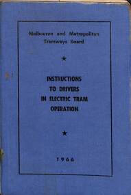
... Ltd, 457 Plenty Road, Preston. On the inside rear cover has..." Dated 1966. Printed by Regent Press Pty Ltd, 457 Plenty Road ...Provides in a Q & A format, instructions to drivers in electric car operation, photos of various types of controllers, an A.B.C. for tramways drivers - "always" points to remember and has a reference index. Issued to F Reale-Key who worked for the Civil Engineering at South Melbourne Depot. Section of the MMTB or The Met and was authorised to drive trams. Demonstrates instructions issued to drivers and to those authorised to drive trams.Forty-Eight page, side staple book within blue Rexine covers and covered with plastic. Titled "Melbourne and Metropolitan Tramways /Electric System /Instructions to Drivers in Electric Car Operation" Dated 1966. Printed by Regent Press Pty Ltd, 457 Plenty Road, Preston. On the inside rear cover has an electric tram driver's certificate issued to F Reale-Key. On the inside front and rear cover has a card trimmed for "The Metropolitan Transit Authority of Victoria". For a photo of Frank standing in front of tram 8, see "MetLines - Vol 1, No. 9 December 1985". See image i2 for details.tramways, trams, mmtb, the met, drivers, training, south melbourne depot, civil engineering department, instructions -
 Greensborough Historical Society
Map, Melbourne and Metropolitan Board of Works. Survey Division, MMBW, Yarra 2500 / 11.22. Bundoora, 1979_01
... streets include: Greenhills Road, Cabernet Crescent and Plenty... Crescent and Plenty Road. Includes Parade College (Christian ...Melbourne and Metropolitan Board of Works. Yarra 2500 [base map] 11-22. Bundoora. Parish of Keelbundoora 2856, Municipalities of Diamond Valley 257 and Whittlesea 239. Prominent streets include: Greenhills Road, Cabernet Crescent and Plenty Road. Includes Parade College (Christian Brothers) and "proposed future freeway" (now Metropolitan Ring Road)MMBW Map in 1:2500 [scale] series. Cream parchment with green tape reinforcing on edges and punched holes on left edge.mmbw, melbourne and metropolitan board of works, shire of diamond valley, bundoora - maps -
 Eltham District Historical Society Inc
Photograph, De Bondy house, Lower Plenty
... Bondy house and property, Main Road, Lower Plenty... melbourne houses main road lower plenty de bondy Four black ...Four black and white photograph reproductions showing De Bondy house and property, Main Road, Lower Plentyhouses, main road, lower plenty, de bondy -
 Greensborough Historical Society
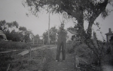
Photograph - Digital image, Edward Henry Blackbourn, 1920c
... Plenty with Main Road in background. Photographs from... at 155 Main Road Lower Plenty with Main Road in background ...Edward Henry Blackbourn, taken at 155 Main Road Lower Plenty with Main Road in background. Photographs from the collection of Peter Blackbourn, a descendant of the Chapman Stock family. Annotations to photos by Peter Blackbourn.Digital copy of black and white photograph.peter blackbourn, edward henry blackbourn