Showing 4334 items
matching railway road
-
 Eltham District Historical Society Inc
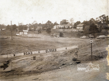
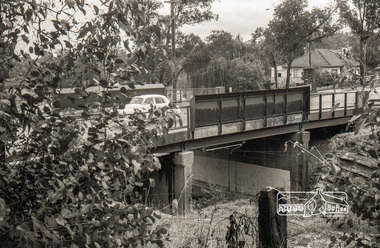
Photograph, Sherbourne Road, Para Road and Simms Road at Briar Hill/Montmorency prior to the upgrade of Sherbourne Road Railway bridge, 3 November 1967, 03/11/1967
... /Montmorency prior to the upgrade of Sherbourne Road Railway bridge, 3... to the upgrade of Sherbourne Road Railway bridge, 3 November 1967 ...Sepia photographNoted in pencil on reverse: "3/11/67". Polaroid Manufacturer's Batch No. A730301K.1967, briar hill, para road, polaroid, sherbourne road, simms road -
 Eltham District Historical Society Inc
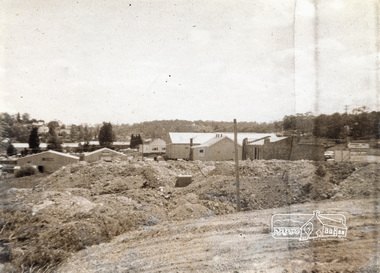
Photograph, Sherbourne Road, Para Road and Simms Road at Briar Hill/Montmorency prior to the upgrade of Sherbourne Road Railway bridge, 3 November 1967, 03/11/1967
... /Montmorency prior to the upgrade of Sherbourne Road Railway bridge, 3.../Montmorency prior to the upgrade of Sherbourne Road Railway bridge, 3 ...Sepia photographPolaroid Manufacturer's Batch No. L767302K.1967, briar hill, para road, polaroid, sherbourne road, simms road -
 Eltham District Historical Society Inc
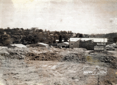
Photograph, Sherbourne Road, Para Road and Simms Road at Briar Hill/Montmorency prior to the upgrade of Sherbourne Road Railway bridge, 3 November 1967, 03/11/1967
... /Montmorency prior to the upgrade of Sherbourne Road Railway bridge, 3.../Montmorency prior to the upgrade of Sherbourne Road Railway bridge, 3 ...Sepia photographPolaroid Manufacturer's Batch No. L767302K.1967, briar hill, para road, polaroid, sherbourne road, simms road -
 Eltham District Historical Society Inc
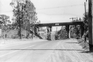
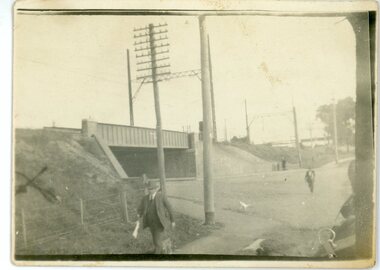
Photograph, Old railway bridge, Sherbourne Road, Montmorency, c.1955
... Old railway bridge, Sherbourne Road, Montmorency..... Registration PG would be about 1952. bridges railways sherbourne road ...Looking northwest in the direction of Eltham to Greensborough. The car is a Ford Prefect A493A which was manufactured in Australia between 1949-1953. The vehicle is fitted with Victorian registration plates which appear to be PG-216. AA-NNN style registration plates were replaced in 1953 with AAA-NNN plates. Registration PG would be about 1952.Printbridges, railways, sherbourne road, montmorency, eltham -
 Ringwood and District Historical Society
Photograph, Warrandyte Road Railway Viaduct . Ringwood 1924
... Warrandyte Road Railway Viaduct . Ringwood 1924... Road Ringwood North melbourne "Written on back of photograph ...Sepia photograph"Written on back of photograph" The new viaduct looking Westward toward Ringwood Railway Station. 10/5/1924 See also photograph mhc096 in NWD 02-09-06, showing costruction of viaduct in 1923. -
 Ringwood and District Historical Society
Photograph, View from Ringwood Clocktower overlooking Wantirna Road railway bridge and Thanet Street corner - Dec. 1969
... View from Ringwood Clocktower overlooking Wantirna Road... View from Ringwood Clocktower overlooking Wantirna Road railway ...Black and white photographWritten on back of photograph: "Wantirna Rd. from clocktower, 1969." -
 Ringwood and District Historical Society
Photograph, View from Ringwood Clocktower overlooking Wantirna Road railway bridge and Thanet Street corner - Dec. 1969
... View from Ringwood Clocktower overlooking Wantirna Road... overlooking Wantirna Road railway bridge and Thanet Street corner ...Black and white photographWritten on back of photograph: "Wantirna Rd bridge. from clocktower, 1969". Thanet Street corner. -
 Ringwood and District Historical Society
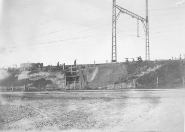
Photograph, Maroondah Highway East, Ringwood- 1923. Start of Warrandyte Road railway bridge construction
... Warrandyte Road railway bridge construction.... Road Ringwood North melbourne Typed below large photograph ...Black and white photograph (3 copies- 2 large, 1 small sepia)Typed below large photograph: "Building Warrandyte Rd. subway 1923. Taken from Maroondah Highway." Written on rear of backing sheet: "Start of Pitt St. viaduct." -
 Eltham District Historical Society Inc
Photograph, Russell Yeoman, Mountain View Road railway bridge, Montmorency, c.1970, 1970c
... Mountain View Road railway bridge, Montmorency, c.1970... melbourne bridge bridges Montmorency Mountain View Road railways ...Roll of 35mm black and white negative film, 4 of 7 stripsIlford HP4bridge, bridges, montmorency, mountain view road, railways -
 Ringwood and District Historical Society
Photograph, Bedford Road Railway Crossing, Ringwood, 1974
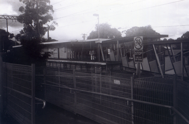
... Bedford Road Railway Crossing, Ringwood, 1974... looking east 1974 Black and white photograph Bedford Road Railway ...Black and white photographTyped under photograph - Bedford Rd Railway Crossing looking east 1974 -
 Ringwood and District Historical Society
Photograph, View from train at the Warrandyte Road Railway Bridge facing west, with Blood Bros. store on the left, and footbridge overhead in the distance
... View from train at the Warrandyte Road Railway Bridge... at the Warrandyte Road Railway Bridge facing west, with Blood Bros. store ...Black and White photograph -
 Ringwood and District Historical Society
Photograph, Bedford Road railway works, 8/1979. Four photographs
... Bedford Road railway works, 8/1979. Four photographs... Road railway works, 8/1979. Four photographs Photograph ...Black and white photograph (4 separate images)Written on back of photograph, "Bedford Rd. railway works, 1979". -
 Ringwood and District Historical Society
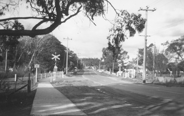
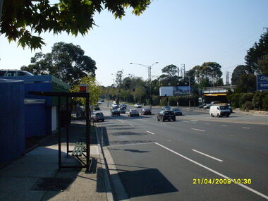
Photograph, Looking east along Maroondah Highway with bus stop on left and Warrandyte Road railway underpass on right, on 21 April 2009
... and Warrandyte Road railway underpass on right, on 21 April... Road railway underpass on right, on 21 April 2009. Photograph ...Ron Brons photographic study of Ringwood. -
 Ringwood and District Historical Society
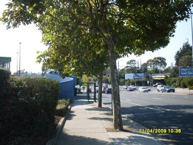
Photograph, Looking along Maroondah Highway looking east with Harris Scarfe on left and Warrandyte Road railway underpass on right, on 21 April 2009
... Scarfe on left and Warrandyte Road railway underpass on right, on... and Warrandyte Road railway underpass on right, on 21 April 2009 ...Ron Brons photographic study of Ringwood. -
 Ringwood and District Historical Society
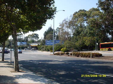
Photograph, Looking across Maroondah Highway looking south-east to the Warrandyte Road railway underpass, on 21 April 2009
... Warrandyte Road railway underpass, on 21 April 2009.... Maroondah Highway looking south-east to the Warrandyte Road railway ...Ron Brons photographic study of Ringwood. -
 Whitehorse Historical Society Inc.
Photograph, Railway tracks looking west, 1/06/2009
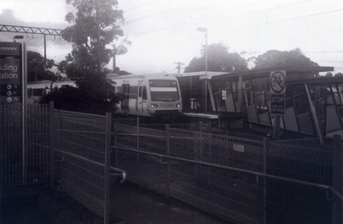
... redevelopment of railway line/springvale road.... the Nunawading Station and the Springvale Road Railway crossing... be eliminated. nunawading railway station springvale road nunawading ...One of a collection of photographs taken of the Nunawading Railway Station prior to the lowering of the railway line and building of the new railway station on the western side of Springvale Road so that the Springvale Road Rail Crossing can be eliminated.Black & white photograph of he precinct surrounding the Nunawading Station and the Springvale Road Railway crossing. This photograph is the railway crossing and tracks looking west to Blackburn. See NP 3545 to NP3567 for the complete set of photographsnunawading railway station, springvale road nunawading, redevelopment of railway line/springvale road. -
 Whitehorse Historical Society Inc.
Photograph, Railway Platform from south side, 1/06/2009
... redevelopment of railway line/springvale road.... the Nunawading Station and the Springvale Road Railway crossing... be eliminated. nunawading railway station springvale road nunawading ...One of a collection of photographs taken of the Nunawading Railway Station prior to the lowering of the railway line and building of the new railway station on the western side of Springvale Road so that the Springvale Road Rail Crossing can be eliminated.Black & white photograph of the precinct surrounding the Nunawading Station and the Springvale Road Railway crossing. This photograph is railway station looking from north side of station. See NP 3545 to NP3567 for the complete set of photographsnunawading railway station, springvale road nunawading, redevelopment of railway line/springvale road. -
 Whitehorse Historical Society Inc.
Photograph, The Railway Crossing from Corner of Springvale Road & Station, 1/06/2009
... redevelopment of railway line/springvale road.... the Nunawading Station and the Springvale Road Railway crossing... be eliminated. nunawading railway station springvale road nunawading ...One of a collection of photographs taken of the Nunawading Railway Station prior to the lowering of the railway line and building of the new railway station on the western side of Springvale Road so that the Springvale Road Rail Crossing can be eliminated.Black & white photograph of he precinct surrounding the Nunawading Station and the Springvale Road Railway crossing. This photograph is of the Railway Crossing from corner of Springvale Road & Station. See NP 3545 to NP3567for the complete set of photographsnunawading railway station, springvale road, nunawading, redevelopment of railway line/springvale road., station street nunawading -
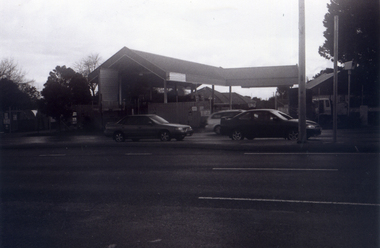
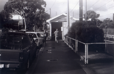
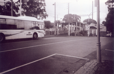 Whitehorse Historical Society Inc.
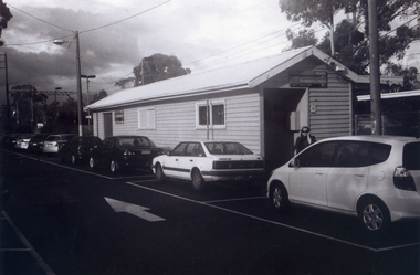
Photograph, Nunawading Railway Station, 1/06/2009
... redevelopment of railway line/springvale road.... the Nunawading Station and the Springvale Road Railway crossing... be eliminated. nunawading railway station springvale road nunawading ...One of a collection of photographs taken of the Nunawading Railway Station prior to the lowering of the railway line and building of the new railway station on the western side of Springvale Road so that the Springvale Road Rail Crossing can be eliminated.Black & white photograph of he precinct surrounding the Nunawading Station and the Springvale Road Railway crossing. This photograph is of the southern entrance from Station Street. Note the Grenda Bus|See NP 3545 to NP3567for the complete set of photographsnunawading railway station, springvale road nunawading, redevelopment of railway line/springvale road., station street nunawading -
 Whitehorse Historical Society Inc.
Photograph, Looking across crossing towards liquor store, 1/06/2009
... redevelopment of railway line/springvale road.... the Nunawading Station and the Springvale Road Railway crossing... be eliminated. nunawading railway station springvale road nunawading ...One of a collection of photographs taken of the Nunawading Railway Station prior to the lowering of the railway line and building of the new railway station on the western side of Springvale Road so that the Springvale Road Rail Crossing can be eliminated.Black & white photograph of he precinct surrounding the Nunawading Station and the Springvale Road Railway crossing. This photograph is the view looking across railway crossing towards liquor store. See NP 3545 to NP3567 for the complete set of photographsnunawading railway station, springvale road nunawading, redevelopment of railway line/springvale road. -
 Whitehorse Historical Society Inc.
Photograph, Nunawading Station looking from the north side, 1/06/2009
... redevelopment of railway line/springvale road.... the Nunawading Station and the Springvale Road Railway crossing... be eliminated. nunawading railway station springvale road nunawading ...One of a collection of photographs taken of the Nunawading Railway Station prior to the lowering of the railway line and building of the new railway station on the western side of Springvale Road so that the Springvale Road Rail Crossing can be eliminated.Black & white photograph of he precinct surrounding the Nunawading Station and the Springvale Road Railway crossing. This photograph is the station looking from the entrance of station on the north side of the tracks. See NP 3545 to NP3567 for the complete set of photographsnunawading railway station, springvale road nunawading, redevelopment of railway line/springvale road. -
 Whitehorse Historical Society Inc.
Photograph, Looking to Booking Office on North side of Nunawading Station, 1/06/2009
... redevelopment of railway line/springvale road.... the Nunawading Station and the Springvale Road Railway crossing... be eliminated. nunawading railway station springvale road nunawading ...One of a collection of photographs taken of the Nunawading Railway Station prior to the lowering of the railway line and building of the new railway station on the western side of Springvale Road so that the Springvale Road Rail Crossing can be eliminated.Black & white photograph of he precinct surrounding the Nunawading Station and the Springvale Road Railway crossing. This photograph is the entrance to the Booking Office for trains from Nunawading travelling east. See NP 3545 to NP3567 for the complete set of photographsnunawading railway station, springvale road nunawading, redevelopment of railway line/springvale road. -
 Whitehorse Historical Society Inc.
Photograph, Nunawading Station - North Side, 1/06/2009
... redevelopment of railway line/springvale road.... the Nunawading Station and the Springvale Road Railway crossing... be eliminated. nunawading railway station springvale road nunawading ...One of a collection of photographs taken of the Nunawading Railway Station prior to the lowering of the railway line and building of the new railway station on the western side of Springvale Road so that the Springvale Road Rail Crossing can be eliminated.Black & white photograph of he precinct surrounding the Nunawading Station and the Springvale Road Railway crossing. This photograph is of the Booking Office and Waiting Rooms on the North side of the Nunawading Station . See NP 3545 to NP3567 for the complete set of photographsnunawading railway station, springvale road nunawading, redevelopment of railway line/springvale road. -
 Whitehorse Historical Society Inc.
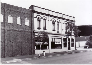
Photograph, Early Building in Blackburn, 6/01/2001 12:00:00 AM
... buildings in Railway Road, Blackburn.... photograph of one of Blackburn's first buildings in Railway Road ...Black and white photograph of one of Blackburn's first buildings in Railway Road, Blackburn.first building, blackburn. -
 Whitehorse Historical Society Inc.
Photograph, Station seen from north side-Platform, 1/06/2009
... redevelopment of railway line/springvale road.... the Nunawading Station and the Springvale Road Railway crossing... be eliminated. nunawading railway station springvale road nunawading ...One of a collection of photographs taken of the Nunawading Railway Station prior to the lowering of the railway line and building of the new railway station on the western side of Springvale Road so that the Springvale Road Rail Crossing can be eliminated.Black & white photograph of he precinct surrounding the Nunawading Station and the Springvale Road Railway crossing. This photograph is a close up view of the south platform at Nunawading from the north side.|See NP 3545 to NP3567for the complete set of photographsnunawading railway station, springvale road nunawading, redevelopment of railway line/springvale road. -
 Port Melbourne Historical & Preservation Society
Flyer - Invitation to planning meeting re campaign against converting the Railway Reserve to a road, Anne Callaghan, 19 Dec 1988
... converting the Railway Reserve to a road... the Railway Reserve into a major road to service the proposed Bayside ...Friends of the Park was established to campaign against the proposal to turn the Railway Reserve into a major road to service the proposed Bayside development. Anne Callaghan was the convenor.Handwritten photocopied invitation to a planning meeting to campaign against converting the Railway Reserve to a major road, an aspect of the 'Bayside' redevelopment, 1988public action campaigns, societies clubs unions and other organisations, transport, parks and gardens, town planning - proposals shelved - bayside, anne callaghan, friends of the park, railway reserve -
 Kew Historical Society Inc
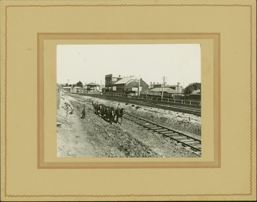
Photograph - Regrading the Camberwell Railway Line near Burke Road, E.J. Dower, 1915
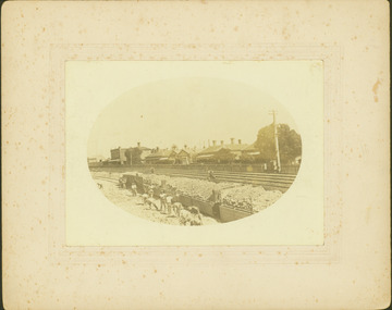
... Regrading the Camberwell Railway Line near Burke Road... Railway Gates on Burke Road / Taken by E.J. Dower"... Camberwell Railway Line / Note Railway Gates on Burke Road / Taken ...One of a series of photographs, taken by Edgar James Dower in the second decade of the twentieth century. Born and raised in Olinda, his family later moved to Surrey Hills. He worked as an adult as a clerk in the city office of the Metropolitan Gas Company, and in his role as a 'collector', he was able to photograph scenes including the construction of tramlines, railways and associated buildings in Kew, Hawthorn, Camberwell and Surrey Hills. Later he established a real estate agency with his brother - the E.J. Dower Real Estate Agency, Dandenong Office.The image is an historically significant record of the development of transport infrastructure which was used to connect Victorians in the first two decades of the twentieth century. This development resulted from increases in population and the consequent extension of Melbourne's suburbs. The photographs, both individually and collectively, richly detail the labour of workers and the tools and machinery used to create and extend Melbourne's public transport network in the years preceding and during World War 1.Digital copy of an original mounted photograph depicting workers regrading the Camberwell Railway line following the demolition of the original Camberwell Railway Station. The level crossing gates at Burke Road can be seen in the distance. Named buildings include The Assembly Hall at right.Verso: "1915 / Regrading Camberwell Railway Line / Note Railway Gates on Burke Road / Taken by E.J. Dower"theme -- connecting victorians by transport and communications, theme - camberwell railway station, theme - travelling by train -
 Kew Historical Society Inc
Photograph - Regrading the Camberwell Railway Line near Burke Road, E.J. Dower, 1915
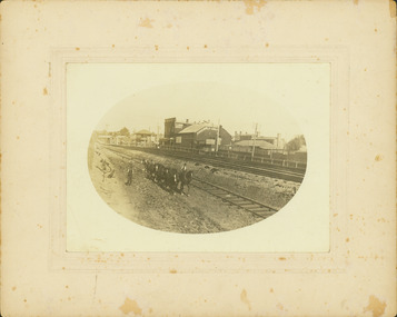
... Regrading the Camberwell Railway Line near Burke Road...Verso: "1915 / Regrading Camberwell railway line, near... Camberwell railway line, near Burke Road / Taken by E.J.Dower ...One of a series of photographs, taken by Edgar James Dower in the second decade of the twentieth century. Born and raised in Olinda, his family later moved to Surrey Hills. He worked as an adult as a clerk in the city office of the Metropolitan Gas Company, and in his role as a 'collector', he was able to photograph scenes including the construction of tramlines, railways and associated buildings in Kew, Hawthorn, Camberwell and Surrey Hills. Later he established a real estate agency with his brother - the E.J. Dower Real Estate Agency, Dandenong Office.The image is an historically significant record of the development of transport infrastructure which was used to connect Victorians in the first two decades of the twentieth century. This development resulted from increases in population and the consequent extension of Melbourne's suburbs. The photographs, both individually and collectively, richly detail the labour of workers and the tools and machinery used to create and extend Melbourne's public transport network in the years preceding and during World War 1.Digital copy of an original oval mounted photograph depicting workers regrading the Camberwell Railway line in the vicinity of Burke Road following the demolition of the original Camberwell Railway Station. Verso: "1915 / Regrading Camberwell railway line, near Burke Road / Taken by E.J.Dower."theme -- connecting victorians by transport and communications, theme - camberwell railway station, theme - travelling by train -
 Kew Historical Society Inc
Photograph - Regrading the Camberwell Railway Line near Burke Road, E.J. Dower, 1915
... Regrading the Camberwell Railway Line near Burke Road...Verso: "1915 / Regrading Camberwell railway line, near... Camberwell railway line, near Burke Road / Taken by E.J.Dower ...One of a series of photographs, taken by Edgar James Dower in the second decade of the twentieth century. Born and raised in Olinda, his family later moved to Surrey Hills. He worked as an adult as a clerk in the city office of the Metropolitan Gas Company, and in his role as a 'collector', he was able to photograph scenes including the construction of tramlines, railways and associated buildings in Kew, Hawthorn, Camberwell and Surrey Hills. Later he established a real estate agency with his brother - the E.J. Dower Real Estate Agency, Dandenong Office.The image is an historically significant record of the development of transport infrastructure which was used to connect Victorians in the first two decades of the twentieth century. This development resulted from increases in population and the consequent extension of Melbourne's suburbs. The photographs, both individually and collectively, richly detail the labour of workers and the tools and machinery used to create and extend Melbourne's public transport network in the years preceding and during World War 1.Digital copy of an original oval mounted photograph depicting workers regrading the Camberwell Railway line following the demolition of the original Camberwell Railway Station. The level crossing gates at Burke Road can be seen in the distance. Named buildings include The Assembly Hall at right.Verso: "1915 / Regrading Camberwell railway line, near Burke Road / Taken by E.J.Dower."theme -- connecting victorians by transport and communications, theme - camberwell railway station, theme - travelling by train -
 Whitehorse Historical Society Inc.
Photograph, The Railway Crossing from Station Street, 1/06/2009
... redevelopment of railway line/springvale road.... the Nunawading Station and the Springvale Road Railway crossing... be eliminated. nunawading railway station springvale road nunawading ...One of a collection of photographs taken of the Nunawading Railway Station prior to the lowering of the railway line and building of the new railway station on the western side of Springvale Road so that the Springvale Road Rail Crossing can be eliminated.Black & white photograph of he precinct surrounding the Nunawading Station and the Springvale Road Railway crossing. This photograph is of the crossing from Station Street. The liquor on the corner of Springvale Road and Oval way is in the background. See NP 3545 to NP3567 for the complete set of photographsnunawading railway station, springvale road nunawading, redevelopment of railway line/springvale road., oval way nunawading