Showing 6008 items
matching residential
-
 Federation University Historical Collection
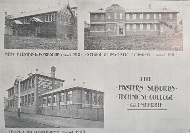
Booklet, Peacock Bros. Printing Company, Eastern Suburbs Technical College, Hawthorn, Plumbing Class, 1912, 1912
The Eastern Suburbs Technical School was located near the Glenferrie Station in Hawthorn. This was the forerunner for Swinburne Technical School, now Swinburne University. The School Council was made up of representatives from the Eastern Suburbs, Hawthorn, Camberwell, Kew. Nunawading. Photographs of rooms and equipment.Soft gray cover with blue print booklet of 24 pages of the Eastern Suburbs Technical College, Hawthorn, with information about office bearers, country plumbing, residential suburbs, plumbing and gas fitting, pattern cutting, ventilation,.eastern suburbs technical college, plumbing, glenferrie station, hawthorn, kew, camberwell, nunawading, swinburne technical school, swinburne university -
 Kew Historical Society Inc
Archive (series) - Subject File, Lyonhouse Museum
Kew Historical SocietySince its foundation in 1958, members of the Kew Historical Society have been compiling and storing information about subjects relating to the history of Kew and its environs, of which this file is an example. Arranged by Secondary Values (value of records to users) Subject file created by researchers of the Kew Historical Society containing information about the Lyonhouse Museum in Cotham Road, Kew. The file contains newspaper articles about the museum, its establishment in a residential area and the reactions of the community.house museums -- kew (vic), lyonhouse museumhouse museums -- kew (vic), lyonhouse museum -
 Ringwood and District Historical Society
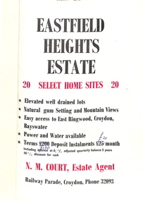
Flyer, Land Sale Brochure, Eastfield Heights Estate, Croydon. (Undated, circa 1950s)
Bi-fold advertisement for 20 residential allotments with locality map of East Ringwood-Croydon area and map of subdivision bounded by Eastfield Road, and The Pass, Croydon. Agent - N.M. Court, Railway Parade, Croydon, Phone 32093. -
 Ringwood and District Historical Society
Map - Plans of Subdivision, Part of Crown Allotments 35 & 39, Parish of Warrandyte
Survey maps of stages 1, 2 & 3 of residential allotments in Kalinda Road and Grayling Crescent, Ringwood, Victoria. (Undated, circa 1960). Some allotments are marked with real estate information and prices in pre decimal £s.Adshead & McGuire, Land Surveyors L.S. M.I.S. (Aust), 268 Albert Street East Melbourne (Ref 118/2a b &c) Tel 41-6960. The land colored blue is set apart for drainage & sewerage purposes. Reference Marks (R.M's) are Gal Iron Pipes 12"x1". Levels shown are to M.M.B.W. Datum. The land shown hatched is subject to innundation. -
 Ringwood and District Historical Society
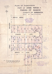
Document, Plan of Subdivision - Part of Crown Portion 7, Parish of Ringwood, County of Mornington - 1962
Map of residential allotments coloured red, with land coloured blue set apart for drainage & sewerage easements. Rubber stamped J.P. Tuohy, Licensed Surveyor, 25 Howe Street Murrumbeena, Tel. 561945, dated 38.8.1962.Map includes Maidstone Street, Norfolk Avenue, Stanhope Court and Wrights Court, Ringwood, Vic. Also includes handwritten Estate Agent sales notations. -
 Ringwood and District Historical Society
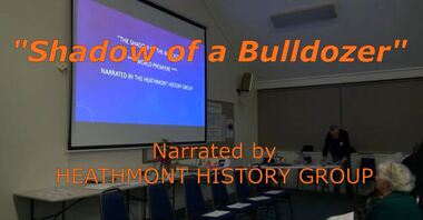
Mixed media - Video, RDHS Guest Speaker Presentation - "Shadow of a Bulldozer" - Heathmont History Group
Digitised video (4.05GB). Duration: 40 minutes. Recorded June, 2019. (Video is available for viewing at Ringwood & District Historical Society Archives by appointment)Presentation: Members of Heathmont History Group address a meeting of RDHS with a reading of a play telling of destruction of orchards in the 1950s/60s and the resistance of change to the landscape and family lifestyles with the onset of residential developments. -
City of Kingston
Photograph - Colour, 6 March 1993
Edithvale is a suburb in the City of Kingston. It is located between Aspendale and Chelsea on the Port Phillip Bay and built within remnant areas of the Carrum Carrum swamp. The foreshore precinct comprises a wide sandy beach, with low sand dunes and numerous historic boat sheds. The suburb consists of older style dwellings and former holiday houses, combined with mid-century housing and newer homes. The large blocks are increasingly subdivided and the existing dwellings demolished to accommodate units and townhouses, thus changing the landscape of the area and reducing the tree canopy.The beachside suburb of Edithvale was previously part of the extensive Carrum Carrum Swamp. The area was once a source of fish and eels for the Mayone-Bulluk clan of the Bunurong people. Over time the area was drained and predominantly devoted to dairy farming and holiday houses. The farms were gradually sold and subdivided with a large number of homes built after World War II and in the 1960s. Edithvale is mainly residential with a shopping strip along Nepean Highway but little significant industry was ever established in the area apart from a plaster works and confectionary factory, both now closed.Laminated aerial colour photograph of Edithvale as viewed from Alexandra Avenue in the north to Ella Grove Chelsea/Edithvale in the south. regents Park Aspendale can be seen in the top left. The area is built-up with residential housing and facilities including Edithvale Primary School, numerous churches and the Edithvale Railway station. Large sections depict the remnant Carrum Carrum swamp. Edithvale Common and the former "Duck Inn" (Melbourne Water/Friends of Edithvale Seaford Wetlands) can be seen. Edithvale Recreational reserve, the valodrome and Edithvale Public Golf Course are prominent. The image shows vacant land in the area now known as Aspendale Gardens and the newer residential section of Chelsea Heights is not developed. A bike path has been established to cover the secondary drain. The Golf Links Court residential development located off Hughes Avenue is a large vacant block.Black type on white adhesive label: 6-3-93 Black type on white adhesive label: 25/9211, 6/3/93, 11.20 am Black type on white adhesive label: 9211 Yellow circular adhesive sticker Black pencil: 9211 6-3-93 arrow pointing Nedthvale, carrum carrum swamp, aspendale, chelsea -
 Ringwood and District Historical Society
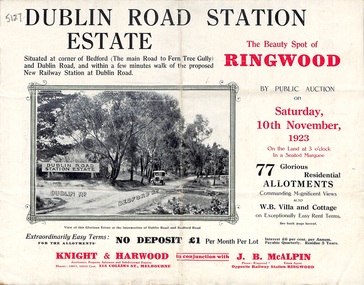
Pamphlet, Land Sale Brochure, Dublin Road Station Estate - 1923
"Extracts from Recent Daily Newspaper - Ringwood Train Service - STATION WANTED AT RINGWOOD EAST. A deputation from the Ringwood East Railway League and Progress Association waited on the chairman of the Railway Commissioners yesterday afternoon and asked that a railway station be erected at Dublin-road, a mile and a quarter from Ringwood. The deputation urged that there were 81 passengers who, if the station were provided, would make daily use of it, and that as the Commissioners had purchased a site for a station at Dublin-road it was evident they had at one time considered it the most suitable site. The Chairman of Commissioners stated that the estimated cost of the station was £3700. Land owners in the locality should pay a proportion of the cost. Members of the deputation replied that there would be no difficulty in raising the money."Multi-fold brochure advertising public auction of residential allotments on Saturday, 10th November, 1923. Brochure includes subdivision features, local facilities and photographic images of the area and details of proposed new railway station at Dublin Road.Subdivision plan includes Dublin Road, Alexandra Road, Vonadawn Avenue, Green Street, Howard Avenue, Wood Street, and Bedford Road (Main Ferntree Gully Road). Auctioneer - Knight & Harwood, 315 Collins Street, Melbourne, Phones Central 10615, 10616. Agent - J.B. McAlpin, Opposite Railway Station, Ringwood, Phone Ringwood 7. -
 Ringwood and District Historical Society
Flyer, Auction Sale Advertisement - Ringwood Station Estate, Ringwood, Victoria - 1919
Folded double-sided brochure advertising auction of residential allotments on Saturday, 11 October, 1919, with town photographs including residence of Mr. and Mrs. Williams on the estate, location map, terms of sale, and summary of local features and services.Subdivision includes Bedford Road and Williams Grove (later Lena Grove). (Agents) Knight & Harwood, 315 Collins Street, Melbourne, Phones Central 10615, 10616, in conjunction with Godbehear & Co., Local Agents, Ringwood, Phone Ringwood 49. -
 Lakes Entrance Historical Society
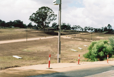
Photograph, Holding M, 2006
Property and subdivision believed to have been done by Bill and Kaye Reddenbach.Colour photograph of early stage of residential development showing roadways formed through property, drainage pipes placed ready for installation, street lighting in place. Photograph taken from school, looking east. Swan Reach Victorialand development, housing -
 Ringwood and District Historical Society
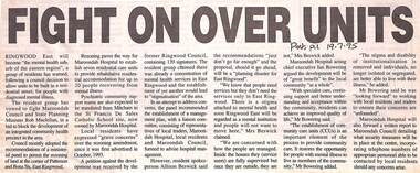
Newspaper, Scrapbook Clipping, Library Collection, Ringwood, Victoria
Newspaper Clipping from "The Post", 19-7-1995. P1. Fight on over unitsRingwood East will become "the mental health suburb of the eastern region" a group of residents has warned, following a council decision to allow units to be built in a residential street, for people with diagnosed mental illness -
 Ringwood and District Historical Society
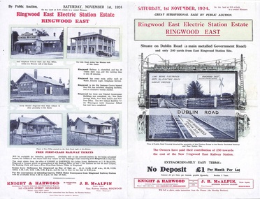
Flyer, Land Sale Auction Brochure, Electric Station Estate, Ringwood East, Vic. - 1924
Folded double-sided advertisement for Ringwood East Electric Station Estate subdivisional sale of retail and residential allotments by public auction on Saturday, 1 November, 1924, with local photographs, terms of sale, and summary of subdivision features and local facilities. Subdivision includes Railway Parade (later Patterson Street, Rosedale Crescent, Federal Road, Howship Avenue (later Howship Court and French Street), and Dublin Road. (Agents) Knight & Harwood, 315 Collins Street, Melbourne, Phone Central 10615, 10616, in conjunction with J.B. McAlpin, Opposite Railway Station, Ringwood, Phone Ringwood 7. -
 Ringwood and District Historical Society
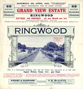
Flyer, Subdivisional Land Auction Sale Brochure, Grand Central Estate, Ringwood, Vic. - 1925
Douglas Street shown in the estate plan did not eventuate, but was developed as a public reserve. Refer also to Reg. No. 5149 for 1924 auction sale of land also titled Grand View Estate situated further north in Ringwood.Double sided multi-folded page advertising public auction sale on Saturday, 31st October, 1925, of residential allotments highlighting local facilities, services and layout of the estate. Includes panoramic view of Ringwood and other local photographic images.Subdivision includes Great Ryrie Street, Heathmont Road, Douglas Street, Garden Street, and Bellevue Avenue. Agents - Knight & Harwood, 315 Collins Street, Melbourne, Phone 10615, 10616 Central, in conjunction with J.B. McAlpin, Opposite Railway Station, Ringwood. Phone Ringwood 7. -
Whitehorse Historical Society Inc.
Article, Group Garden Turfed Out, 1992
The proposed Government sale of part of Nunawading Youth Residential Centre has forced one of Nunawading's Community Gardens out of its home.The proposed Government sale of part of Nunawading Youth Residential Centre has forced one of Nunawading's Community Gardens out of its home. The families involved are very upset, but the Council has no formal agreement with the Government over the use of the land.The proposed Government sale of part of Nunawading Youth Residential Centre has forced one of Nunawading's Community Gardens out of its home. community gardens, nunawading youth residential centre, community services victoria, nunawading community gardens -
 Bayside Gallery - Bayside City Council Art & Heritage Collection
Map - print, Melbourne and Metropolitan Board of Works, Interim development order: Brighton, Moorabbin and Sandringham, 1959
The Melbourne and Metropolitan Board of Works (now Melbourne Water) was established in 1891. From that time, as part of their work laying water and sewerage connections, they created detailed plans of houses and other buildings in the Melbourne metropolitan area. In 1956 it acquired powers to construct and maintain highways and bridges, protect and improve the foreshores and create and maintain parks within the metropolitan region. This Interim development order comprises part of the municipalities of Brighton, Moorabbin and Sandringham and was made on 20 October 1959.brighton, moorabbin, sandringham, melbourne and metropolitan board of works, map, town planning, cartographic material, interim development order, bayside -
 Lakes Entrance Historical Society
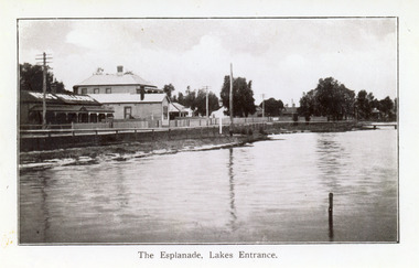
Postcard - Lakes Entrance, 1920c
Also black and white 9 x 14 cm copy, but not Vogt, inscription The Esplanade, Lakes EntranceBlue and white postcard showing a section of the western end of Esplanade, showing lake, foreshore, Vize's Cafe, Bellevue Guest House, Police Station, Maranui Guest House and, partially hidden by trees, residential houses. Lakes Entrance VictoriaLakes Entrance The Esplanadeguesthouses, township, police, retail trade -
 Lakes Entrance Historical Society
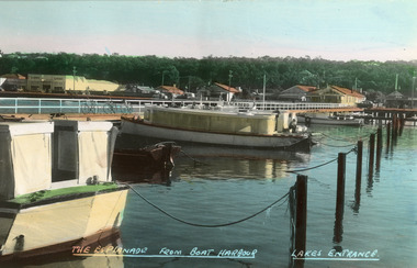
Postcard - Boat Harbour, Bulmer H D, 1940c
Colour postcard of Esplanade. It shows the boat harbour at the western end of Cunninghame Arm. Launches pictured at moorings, residential houses shown on Esplanade. Thick vegetation on Kalimna Heights escarpment in background, with glimpse of Holiday Inn. Lakes Entrance VictoriaEsplanade from Boat Harbour Lakes Entrancehouses, waterfront, boats and boating -
Glen Eira Historical Society
Document - Residential Certificate 1909-11
This file contains one item relating to residential certificates: 1/A photocopy of the residential certificate of Margaret Agnes Stewart of North Road, Elsternwick, that certifies her to vote in elections, 29/04/1909.elsternwick, stewart margaret agnes, north road, atkinson beryl l., elections, certificates, electoral rolls -
 Ringwood and District Historical Society
Flyer, Subdivisional Land Auction Sale Brochure, Grand Central Estate, Ringwood, Vic. - 1924
Refer also to Reg. No. 5148 for 1925 auction sale of land also titled Grand View Estate situated further south in Ringwood.Double sided multi-folded page advertising public auction sale on Saturday, 5th April, 1924, of residential allotments highlighting local facilities, services and layout of the estate. Includes panoramic view over the estate and other local photographic images.Subdivision includes Whitehorse Road, Rupert Street, Herbert Street. and Leonard Street. Agents - Knight & Harwood, 315 Collins Street, Melbourne, Phone 10615, 10616 Central, in conjunction with J.B. McAlpin, Opposite Railway Station, Ringwood. Phone Ringwood 7. -
 Ringwood and District Historical Society
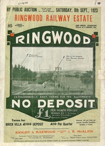
Flyer, Subdivision Advertisement - Ringwood Railway Estate Public Auction - 1923
Refer also to Reg. No. 5185 for Ringwood Railway Estate final section release (August 1924)Folded double-sided brochure advertising 85 residential allotments and brick cemented villa - Ringwood Railway Estate Public Auction on Saturday 8th September, 1923, with town photographs, location map, terms of sale, and summary of local features and services.Subdivision includes Whitehorse Road, Bon View Avenue, Grant Crescent, Heatherbrae Avenue, Burwood Avenue, and Sherbrooke Avenue. (Agents) Knight & Harwood, 315 Collins Street, Melbourne, Phones Central 10615, 10616, in conjunction with J.B. McAlpin, Opposite Railway Station, Ringwood, Phone Ringwood 7. -
 Lakes Entrance Historical Society
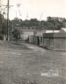
Photograph, Lakes Post Newspaper, 1991
Newspaper article appeared in Lakes Post 28 August 1991Black and white photograph showing Graham Ellis demolishing a residence at 37 Carpenter Street, formerly lived in by Viv and Tommy Harbeck. During demolition many old newspapers were found. Site was redeveloped as residential units. Lakes Entrance Victoriahouses, historic site -
 Eltham District Historical Society Inc
Photograph, N. J. Tillings Timber Factory, 15 June, 1975, 15/06/1975
N. J. Tillings Timber Factory was part of the Brougham Street, Light industrial area, Eltham. Brick bulidings includes signage: Wakefield Pr... (printer?) No 17 Building C. This is one of 7 B/W 8x10 inch photos with notes on obverse by Dick Crichton. Accompanying letter from Florence Chrichton 2013 : "Originally sent to Shire of Eltham Engineer, Mr. McDonald. [These photographs were part of their campaign to the Shire of Eltham in 1975] claiming that the zoning regulations were being breached by the occupants of various factories in the nearby light industrial zone [Brougham Street, Eltham] - to the detriment of those living in adjoining residential zones, and that, despite .. earlier objections and complaints, nothing was done about it."1 black and white photograph printed with white borderInscribed on back: "Weekend photograph of factories in Brougham Street surrounded by by residential zone. On weekdays cars surround premises - these have been built approx. two years - where is the landscaping? * Undeveloped light industrial land. Careful planning needed for future. Being on high elevations backs of future buildings will be seen from Main Road Eltham and future Art Centre complex. Also Bolton Street becoming heavily used arterial road. Off street parking facilities most important." . The front of the photo has pen marks indicating points of interest.industrial estate, brougham street, eltham -
 Ringwood and District Historical Society
Flyer, Land Sale Advertisement - State School Estate, Ringwood, Victoria - 1923
The date of the flyer as circa 1920 can be estimated from the references to the (decision on) "electrification of the Croydon Railway Line" which eventually occurred in 1923, letting of tenders for the state school building which opened in 1924, and the "proposed new railway station" (East Ringwood) which opened in 1925, Advertisement for State School Estate, Ringwood - 26 residential allotments for sale near East Ringwood State School development site and 7 minutes walk from proposed new railway station (East Ringwood). Includes location map and terms of sale.Locality plan includes King Street and Government Roads (Later Everard Road, Holland Road, Purser Avenue, and Charles Street). (Agents) J.B. McAlpin, Estate Agent and Subdivisional Manager, Ringwood (Opposite Station), and F.V. Parker, Estate Agent, Main Street, Ringwood. -
 Ringwood and District Historical Society
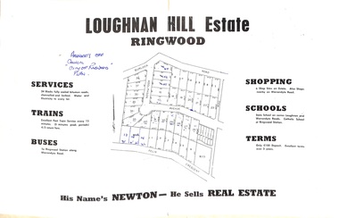
Document - Folder, Subdivision Map - Loughnan Hill Estate, Ringwood, Victoria - circa 1960
Open centre page of land sale brochure glued to manilla folder. Map of residential and shop sites in Burlock Road (later Burlock Avenue), Adolphson Avenue and Felix Crescent, Ringwood, with summary of estate facilities and local services. Agent - T.G. Newton.(Page glued to manilla folder prevents access to front page for further sale information) -
Port Melbourne Historical & Preservation Society
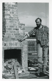
Photograph - Conversion of Harper's factory to Sandridge Bay Towers, Janet Bolitho, 1994
Three colour photographs of the conversion of Harpers Starch Factory to Sandridge Bay Towers (residential) .01 - Large colour photograph of building looking towards Bay .02 - Chimney and factory taken from Esplanade West .03 - Construction with pink cement mixer in foregroundbuilt environment - industrial, built environment - commercial, built environment - domestic, architecture, harpers starch factory, sandridge bay towers -
 Royal Australian and New Zealand College of Obstetricians & Gynaecologists (RANZCOG)
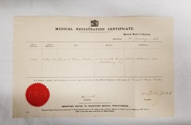
Document - Medical Registration certificate issued to Dr Margaret Alison Mackie, 8 January 1936
Dr Margaret Alison Mackie (1910-1991) was in active practice between 1936 and 1970. She was a Fellow of the College, and was appointed a Commander of the Order of St Michael and St George (CMG) for services to medicine in 1975. Paper certificate registering Dr Margaret Alison Mackie as a doctor. Issued by the Medical Board of Victoria, the certificate lists Dr Mackie's certificate number, residential address, and qualification, and is affixed with a red wax seal at bottom left. The certificate is dated January 8th, 1936.ephemera, medicine -
 Ringwood and District Historical Society
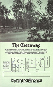
Document - Folder, Greenway Estate Subdivision, Heathmont, Victoria - 1981
Manilla folder containing single page advertisement for sale of 13 residential allotments, photocopied plan section of surveyor's certificate, letter from vendor to agent dated 24th February, 1981, and typewritten price list. Subdivision includes Possum Lane and The Greenway, Heathmont. Vendor - Townshend Homes (Vic) Pty Ltd., 395 Canterbury Road, Vermont, 3133, Phone 874-1066. P.O. Box 64, Vermont, 3133. Agent - C.E. Carter & Son, 122 Whitehorse Road, Ringwood, Vic., 3134. -
 Ringwood and District Historical Society
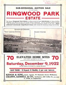
Flyer, Sub-divisional auction sale advertisement - Ringwood Park Estate, Ringwood, Vic. - 1922
Folded double-sided page with black and white photographs of local views with black and red print advertising auction sale on Saturday 9th December, 1922, - 70 residential home sites, including terms of sale, locality map, and description of local facilities and services. Subdivision includes Wonga Road (later Loughnan Road), William Street, Andrew Street, and Harrison Street. Vendors Solicitors - Rigby & Fielding, 60 Market Street, Melbourne. Estate Agents - Keogh & King, 70 Elizabeth Street, Melbourne, Telephone 6938. Auctioneer - Cranny, Sambell & Co., 325 Collins Street, Melbourne, Telephone Central 5067 and 5077. -
 Mission to Seafarers Victoria
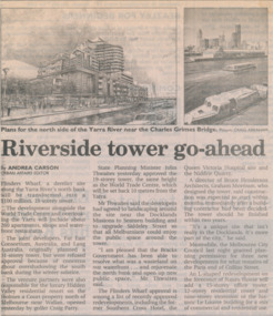
Article - Newspaper clipping, The Age, Riverside Tower Go Ahead, 28 February 2001
The article was written by Andrea Carson and published in the Age 2001The article relates to the renewal of the warves and the impact of the modernisation.Newspaper clipping from the Age 2001, with a sketch of a new development near the Mission.yarra river, australian wharf, residential, siddeley street -
Glenelg Shire Council Cultural Collection
Plan - Plan - subdivision at Cape Bridgewater, n.d
Black and white photocopy of a 1990s plan of a subdivision at Cape Bridgewater - 'Heritage Valley'. Twenty-eight lots . In two halves, not joined togethertown planning, residential, sub divide, cape bridgewater