Showing 8845 items
matching the lake
-
 Lakes Entrance Historical Society
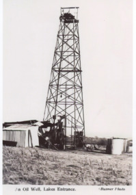
Photograph, Bulmer, Oil rig Lakes Entrance Victoria, 1940 c
Thought to be on the Fosters property c1940Black and white photograph of a postcard showing an oil rig on a property Lakes Entrance VictoriaAn Oil Well Lakes Entrancecivil engineering, oil and gas industry -
 Lakes Entrance Historical Society
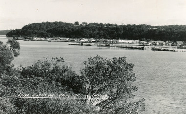
Postcard - Lakes Entrance, Bulmer H D, 1950
Black and white postcard of the township of Lakes Entrance, taken form the south bank of Cunninghame Arm, showing the boat haven, buildings along Esplanade, and the Kalimna escarpment in the distance. Lakes Entrance VictoriaLakes Entrance from Ocean Beachtownship, waterways -
 Kew Historical Society Inc
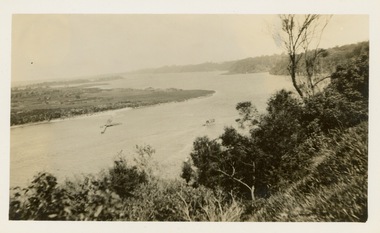
Photograph - Victorian Canoe Club, Gippsland Lakes, 1935
Canoeing on the River Yarra at Melbourne was an important and widespread recreational pursuit for Melbournians, especially in the first half of the twentieth century. The Victorian Canoe Club was formed in 1912 at a meeting in Melbourne and its first committee elected in the same year. Records indicate that the Club continued into at least the 1950s .The photos in this album are historically and socially significant as a record of recreational activities in the first half of the twentieth century. A number of photographs in the album provide views of sections of the Yarra, as well as areas in regional Victoria, that may otherwise be unavailable.One of 12 sepia [faded] photographs of members of the Victorian Canoe Club. This photo was taken by a member of the club on a later trip to the Gippsland Lakes and Mallacoota in 1935."Gippsland Lakes"victorian canoe club, travel -- 1930s, gippsland lakes -
 Stawell Historical Society Inc
Photograph - Slide, Cato Lake & Swimming Pool Stawell
Coloured Photograph looking across Cato Lake toward old poolCato Lake & Swimming Pool Stawell -
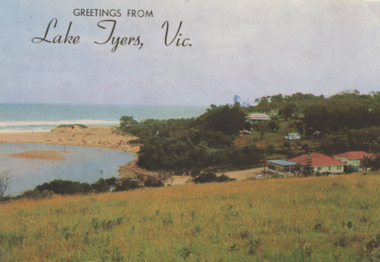 Lakes Entrance Historical Society
Postcard - Lake Tyers
Colour Photograph of Lake Tyers Beach and Kiosk, many people on the beach Greetings from Lake Tyers Vicboats and boating, forest, waterways, jetties, beaches -
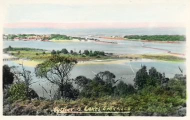
 Lakes Entrance Historical Society
Postcard - Bullock Island Lakes Entrance, H D Bulmer, 1950 c
Bullock Island and first traffic bridge. Bullock Island has no development. North Arm bridge and Princes Highway in foreground, New Works area across Cunninghame Arm in distance Lakes Entrance Victoria. Also a cut down colour photograph of second humpy bridge to Bullock Island donated by M Fish number 04208.1 size 3 x 13 cm|Also two black and white photographs numbers 04208.2 and 04208.3 in SparesColour tinted postcard of Bullock Island and first traffic bridge. Bullock Island has no development. North Arm bridge and Princes Highway in foreground, New Works area across Cunninghame Arm in distance Lakes Entrance Victoria. Also a cut down colour photograph of second humpy bridge to Bullock Island donated by M Fish number 04208.1 size 3 x 13 cm|Also two black and white photographs numbers 04208.2 and 04208.3 in Spares Bullock Island and Bridge Lakes Entrance waterways, gippsland lakes, islands, vegetation -
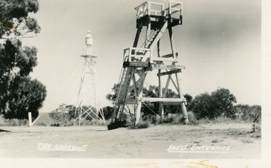 Lakes Entrance Historical Society
Postcard - Lookout tower Jemmy's Point, Bulmer H D, 1950
Black and white postcard of the timber lookout on Jemmys Point, with the signal light on steel tower nearby. Lakes Entrance Victoria,The Lookout, Lakes Entrancehistoric sites, navigation -
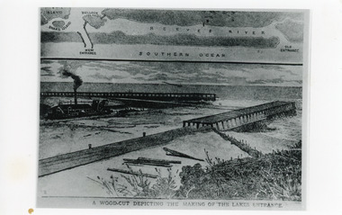 Lakes Entrance Historical Society
Photograph - Entrance Works, 1880c
Photographic reproduction of woodcut drawing of the building of the entrance and map above of location.Black and white photograph of a woodcut showing dredge working between timber constructed piers on entrance from the lakes to the ocean Bass Strait. Piers unfinished, timber lying around, sand in the entrance. Map above showing position of the lakes, old and new entrances, southern ocean and sand dune vegetation. Lakes Entrance VictoriaA woodcut depicting the making of the Lakes Entrance.public works, dredging, waterways -
 Ballaarat Mechanics' Institute (BMI Ballarat)
The Promenade Viewpoint Lake Wendouree
... The Promenade Viewpoint Lake Wendouree ...This photograph is from the Max Harris Collection held by the Ballaraat Mechanics' Institute. Please contact BMI for all print and usage inquiries.ballarat, lake wendouree, the promenade -
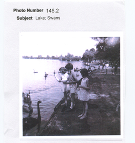 Friends of Ballarat Botanical Gardens History Group
Work on paper - Three Children Feeding the Swans at Lake Wendouree, Free Time by Lake Wendouree, Ballarat
... Three Children Feeding the Swans at Lake Wendouree. ...john garner collection, ballarat botanical gardens, gardens, ballarat, swans, lake wendouree -
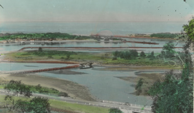
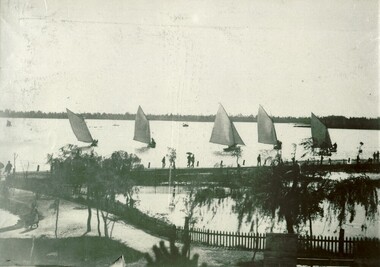
 Lakes Entrance Historical Society
Postcard - North Arm Lakes Entrance Victoria. c1930, 1930 c
04324.1, 9 x 14 cmBlack and white postcard showing two people in a rowing boat on the lower reaches of the North Arm looking downstream Lakes Entrance Victoria c1930. Second black and white postcard of lower reaches of North Arm looking upstream Lakes EntranceNorth Arm Lakes Entrancewaterways, topography, vegetation -
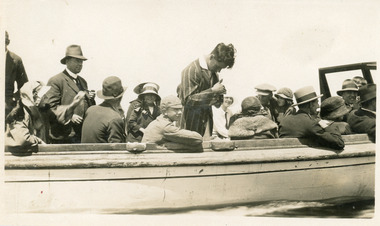 Lakes Entrance Historical Society
Photograph, 1925
Date made January 1925Black and white photograph showing crowd of tourists aboard ferry on lakes, at Lakes Entrance, Victoria.Alf and Jeans Honeymoon, Photo at Lakes Entrance, Jan 1925 (on back)waterways, boats and boating, tourism, celebration -
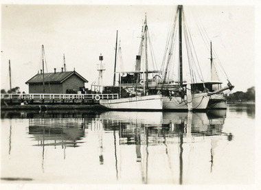
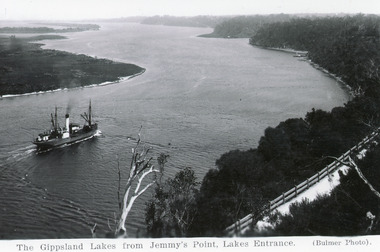 Lakes Entrance Historical Society
Postcard - SSTambar, c1930
Black and white postcard of SS Tambar in the channel, heading westward toward Nungurner and Metung. Photo taken from Kalimna hill with Jemmy's Point road in foreground. Lakes Entrance VictoriaGippsland Lakes from Jemmy's Point, Lakes Entrance.ships and shipping, waterways -
 Ringwood and District Historical Society
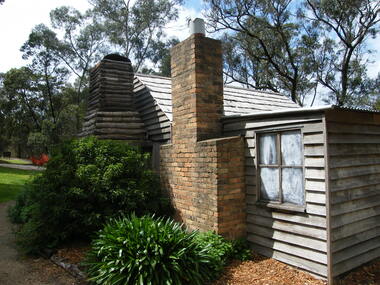
Photograph, Showing the exterior views of the facsimile of the miner's hut, located at the back of Ringwood Lake, from the original that once stood on Maroondah Highway in the 1870s onwards. The cottage was erected by the Ringwood City Council in conjunction with Ringwood Historical Research Group (now Ringwood & District Historical Society). Officially opened by Mayor Cr Pat Gotlib JP on 29th May 1983
... hut, located at the back of Ringwood Lake, from the original ...Photographic record by Russ Haines, RDHS, in October 2008. -
 Ringwood and District Historical Society
Photograph, Showing the interior views of the facsimile of the miner's hut, located at the back of Ringwood Lake, from the original that once stood on Maroondah Highway in the 1870s onwards. The cottage was erected by the Ringwood City Council in conjunction with Ringwood Historical Research Group (now Ringwood & District Historical Society). Officially opened by Mayor Cr Pat Gotlib JP on 29th May 1983
... hut, located at the back of Ringwood Lake, from the original ...Photographic record by Russ Haines, RDHS, in October 2008. -
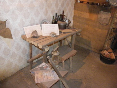
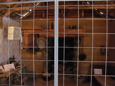 Ringwood and District Historical Society
Photograph, Showing the tools and equipment rooms of the facsimile of the miner's hut, located at the back of Ringwood Lake, from the original that once stood on Maroondah Highway in the 1870s onwards. The cottage was erected by the Ringwood City Council in conjunction with Ringwood Historical Research Group (now Ringwood & District Historical Society). Officially opened by Mayor Cr Pat Gotlib JP on 29th May 1983
... the miner's hut, located at the back of Ringwood Lake, from ...Photographic record by Russ Haines, RDHS, in October 2008. -
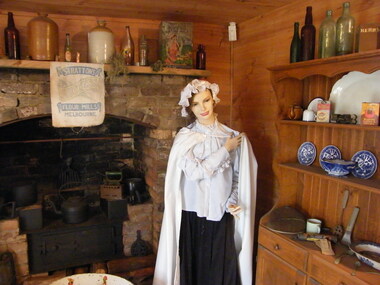
 Ringwood and District Historical Society
Photograph, Showing the living rooms of the facsimile of the miner's hut, located at the back of Ringwood Lake, from the original that once stood on Maroondah Highway in the 1870s onwards. The cottage was erected by the Ringwood City Council in conjunction with Ringwood Historical Research Group (now Ringwood & District Historical Society). Officially opened by Mayor Cr Pat Gotlib JP on 29th May 1983
... hut, located at the back of Ringwood Lake, from the original ...Photographic record by Russ Haines, RDHS, in October 2008. -
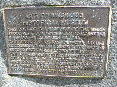 Ringwood and District Historical Society
Photograph, The official plaque of the facsimile of the miner's hut, located at the back of Ringwood Lake, from the original that once stood on Maroondah Highway in the 1870s onwards. The cottage was erected by the Ringwood City Council in conjunction with Ringwood Historical Research Group (now Ringwood & District Historical Society). Officially opened by Mayor Cr Pat Gotlib JP on 29th May 1983
... , located at the back of Ringwood Lake, from the original that once ...Photographic record by Russ Haines, RDHS, in October 2008. -
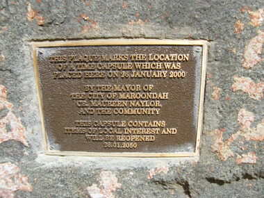 Ringwood and District Historical Society
Photograph, The time capsule of the facsimile of the miner's hut, located at the back of Ringwood Lake, from the original that once stood on Maroondah Highway in the 1870s onwards. The capsule will be reopened on 28 January 2050. The cottage was erected by the Ringwood City Council in conjunction with Ringwood Historical Research Group (now Ringwood & District Historical Society). Officially opened by Mayor Cr Pat Gotlib JP on 29th May 1983
... , located at the back of Ringwood Lake, from the original that once ...Photographic record by Russ Haines, RDHS, in October 2008. -
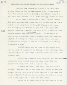 Ringwood and District Historical Society
Document, Paul Kempton, The Effects of the Environment on the Ringwood Lake by Paul Kempton - 1983 (2 pages), 1983
... The Effects of the Environment on the Ringwood Lake by Paul ... -
 Victorian Aboriginal Corporation for Languages
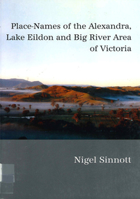
Book, Nigel Sinnott, Place-names of the Alexandra, Lake Eildon and Big River area of Victoria, 2003
... Place-names of the Alexandra, Lake Eildon and Big River ...Contains 2000 entries for the Alexandra area, giving a clearly detailed description of the site and source of the name.Maps, colour photographsplace names, alexandra, lake eildon, strathbogie ranges, yea, marysville, healesville -
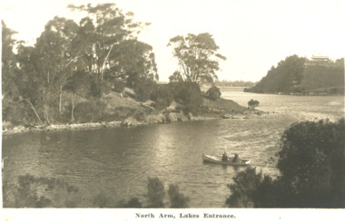
 Lakes Entrance Historical Society
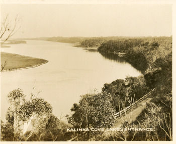
Postcard - Reeves Channel, Valentine Series, 1930c
Black and white small format postcard of Reeves Channel Gippsland Lakes, taken from Jemmys Point. It shows a glimpse of the Princes Highway, the steep shoreline of the mainland opposite Rigby Island with Fraser Island and Flannagan Island in distance. Lakes Entrance VictoriaKalimna Cove Lakes Entranceislands, waterways, topography -
 Lakes Entrance Historical Society
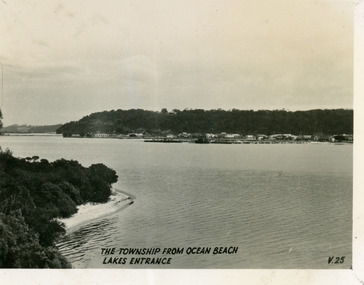
Postcard - Township, 1930c
Black and white small format postcard of the town, taken from the south shore of the lake. It shows a distant view of the town with Jemmys Point and Kalimna Heights in the background, portion of vegetation and south shore beside lake in foreground. Lakes Entrance VictoriaThe Township from Ocean Beach, Lakes Entrance V25vegetation, township, waterfront -
 Lakes Entrance Historical Society
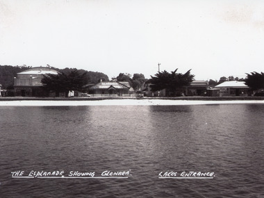
Photograph - Glenara Guest House, Bulmer H D, 1935c
Copy black and white photograph of a section of Esplanade, viewed from the front lake. Buildings in view are the Prince Regent Theatre including the chemist shop, the original Glenara Guest House, and shops. Lakes Entrance VictoriaThe Esplanade showing Glenara, Lakes Entrancecinema, guesthouses, township, waterfront -
 Lakes Entrance Historical Society
Postcard - Western Wharf, 1930c
Also black and white enlargement 18x25cmBlack and white small format postcard of the Western wharf. Shown on the wharf a shed and signal light. Four boats moored including either Omeo or Dargo. Reflections on calm waters of lake. Lakes Entrance VictoriaOn back 'Western Wharf Lakes Entrance'jetties, waterfront, ships and shipping -
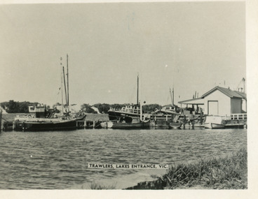 Lakes Entrance Historical Society
Postcard - Trawlers, 1955c
Black and white small format postcard showing trawlers at the eastern wharf. One vessel identified as Irak. Lakes Entrance VictoriaTrawlers Lakes Entrancejetties, boats and boating, waterfront -
 Lakes Entrance Historical Society
Postcard - Bullock Island, Bulmer H D, 1920c
Hand coloured postcard of Bullock Island and the man made entrance from Bass Strait to the Gippsland Lakes. Also shown the small township, unofficially known as Carpentertown at the entrance works. Photo taken from Kalimna Hill, shrubbery in foreground. Lakes Entrance VictoriaBullock Island, Lakes Entrancewaterways, bridges, islands, jetties -
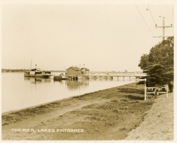 Lakes Entrance Historical Society
Postcard - Western Wharf, Valentine Series, 1930c
Also sepia copy 10x15cm, black and white copies 10x17cm, and 14x24cmSepia coloured small format postcard of the Western wharf, Lakes Entrance, Victoria. It shows the pier variously called the Post Office Jetty, Freemans Jetty, as the steamer leaves. Smaller vessels moored beside jetty. Shoreline edged with bluestone, wooden tree guard surrounding young memorial cypress tree. Lakes Entrance VictoriaThe Pier Lakes Entrancememorials, jetties, waterfront, ships and shipping -
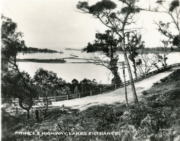 Lakes Entrance Historical Society
Postcard, 1930c
Also faded copy identical imageBlack and white small format postcard of the Princes Highway at Jemmys Point. It shows the road winding around the hill between the scrub covered hill and the post and rail guard fence, Bullock Island and rock groynes in the lake also entrance in distance. Lakes Entrance VictoriaPrinces Highway, Lakes Entranceislands, fences, roads and streets -
 Lakes Entrance Historical Society
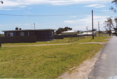
Photograph - Lake Tyers Aboriginal Trust Lake Tyers Victoria, 1/08/2008 12:00:00 AM
Rules Road at the Lake Tyers Aboriginal Trust Lake Tyers Victoria. This photograph was taken at the time of 150 years Lakes Entrance 1858 to 2008 display held in 2008Colour photograph of houses on Rules Road at the Lake Tyers Aboriginal Trust Lake Tyers Victoria. plus 2 other photos of the Lake Tyers Aboriginal Trust Lake Tyers Victoria.aboriginals, land settlement, events, houses