Showing 427 items
matching topography
-
 Lakes Entrance Historical Society
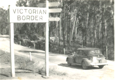
Postcard, Victorian Border sign East Gippsland Victoria, 1940 c
Black and white postcard showing a sedan driving by the Victorian Border sign East Gippsland Victoriaroads and streets, topography, vehicles -
 Lakes Entrance Historical Society
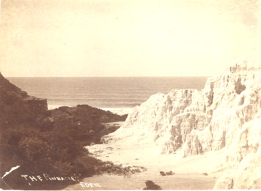
Photograph, A Davis Eden, Pinnacles Eden N.S.W, 1940 c
Sepia toned photograph showing a view of the ocean from the spectacular cliffs known as the Pinnacles Eden N.S.W.The Pinnacles Edencoast, ocean, topography -
 Lakes Entrance Historical Society
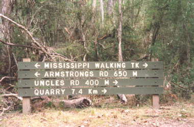
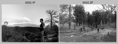
Photograph, Davies Judy, walking tracks in Colquhoun Forest, East Gippsland, c2000
other photos taken during excursion to Colquhoun Forest same day. Pictured are Tim Gibson and Leigh Davies Colour photograph of a signpost indicating Mississippi walking tracks , Armstrong Rd, Uncles Track and Quarry in Colquhoun Forest, East Gippsland. Plus six other photos.forest, recreation, topography -
 Lakes Entrance Historical Society
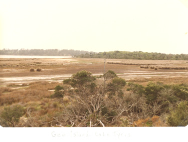
Photograph, Marie Fish, Gem Island Lake Tyers Victoria, 1980 c
colour photograph taken at low tide of Gem Island , Lake Tyers Victoria. Plus four other photos of canoe trees on the Island topography, vegetation, gippsland lakes -
 Lakes Entrance Historical Society
Photograph, Deputy Premier John Thwaite opening Cunninghame Circuit Lakes Entrance, Victoria, 25.5.2001
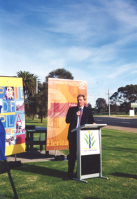
Opening of Cunninghame Circuit Lakes Entrance Colour photograph of Deputy Premier John Thwaites. Plus three other photos of same event waterways, tourism, topography -
 Eltham District Historical Society Inc
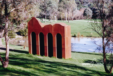
Photograph, Sculpture 'Classical Landscape' by Cliff Burtt, Alistair Knox Park, Eltham
Iron sculpture by Cliff Burtt welcomes visitors to the Gateway of Eltham. It was constructed of Corten Steel in 1994 and won the Eltham Public Art Award in 1996. “Award winning sculptor, Cliff Burtt, often references the geometry of architectural forms in his bold, minimalist public sculptures. In this corten steel work the repeated arches of the temples of antiquity are in dialogue with the nearby spans of the railway trestle bridge that cuts through the Eltham parkland. The formality of the architecture is offset by the organic sweeps of the top profile of the work, which playfully acknowledges the hilly topography of the region” – Highlights from the Nillumbik Art Collection Two colour photographs of iron sculptureclassical landscape, sculptures, art, parks, alistair knox park, eltham, cliff burtt, public art -
 Bendigo Military Museum
Photograph - 4th Field Survey Squadron Adventurous Training, Wilpena pound, Flinders Ranges, SA, 1989
This is a set of 43 photographs of a 4th Field Survey Squadron adventurous training held at Wilpena pound, in the Flinders Ranges of South Australia in 1989. It is evident the training focussed on teamwork, leadership, abseiling, rock climbing, field craft and living off the land survival skills. Elements from units of the Army Reserve also participated in the training. In this photo set, one of 4th Field Survey’s sections participated in abseiling and trekked to the highest mountain in the Flinders Ranges – St. Mary’s Peak. Refer to items 6553.56P for additional colour photographs taken during the adventurous training exercise.This is a set of 43 photographs of 4th Field Survey Squadron personnel undergoing adventurous training held at Wilpena pound, in the Flinders Ranges of South Australia in 1989. The black & white photographs are on 35mm negative film and are part of the Army Survey Regiment’s Collection. The photographs were scanned at 96 dpi. .1) - Photo, black & white, 1989. L to R: SGT Laurie Justin, SGT Stu Symonds. .2) - Photo, black & white, 1989. L to R: SGT Stu Symonds, CPL Roger Graf, SSGT Max Coletti, SPR Cheryl Deluca-Cardillo, SPR Andrew Quin. .3) & .4) - Photo, black & white, 1989. Wilpena Pound topography. .5) - Photo, black & white, 1989. SGT Stu Symonds. .6) - Photo, black & white, 1989. Abseiling ropes and equipment. .7) to .16) - Photo, black & white, 1989. Abseiling activities, unidentified soldier. .17) to .18) - Photo, black & white, 1989. Abseiling activities, CPL Michelle Griffith. .19) - Photo, black & white, 1989. L to R: unidentified (x5), SGT Mick Hogan, unidentified (x3). .20) - Photo, black & white, 1989. L to R: CPL Roger Graf, CPL Michelle Griffith, SPR Cheryl Deluca-Cardillo, SGT Laurie Justin, SSGT Max Coletti, SPR Andrew Quin. SGT Stu Symonds. .21) - Photo, black & white, 1989. L to R: unidentified (x2), SGT Stu Symonds. .22) & .23) - Photo, black & white, 1989. Wilpena Pound topography. .24) - Photo, black & white, 1989. SSGT Max Coletti. .25) - Photo, black & white, 1989. SSGT Max Coletti, SPR Cheryl Deluca-Cardillo, SGT Stu Symonds. .26) - Photo, black & white, 1989. SGT Stu Symonds. .27) - Photo, black & white, 1989. L to R: CPL Michelle Griffith, SPR Cheryl Deluca-Cardillo, SSGT Max Coletti, SGT Laurie Justin, SPR Andrew Quin, CPL Roger Graf, SGT Stu Symonds. .28) &.29) - Photo, black & white, 1989. Wilpena Pound topography. .30) - Photo, black & white, 1989. SGT Stu Symonds. .31) - Photo, black & white, 1989. CPL Michelle Griffith. .32) - Photo, black & white, 1989. L to R: CPL Michelle Griffith, SGT Stu Symonds, SSGT Max Coletti, SGT Laurie Justin. .33) - Photo, black & white, 1989. L to R: CPL Michelle Griffith, SGT Stu Symonds, CPL Roger Graf (standing), SSGT Max Coletti, SGT Laurie Justin. .34) - Photo, black & white, 1989. L to R: SGT Stu Symonds, CPL Michelle Griffith, CPL Roger Graf (standing), SSGT Max Coletti, SGT Laurie Justin. .35) to .37) - Photo, black & white, 1989. Wilpena Pound topography. .38) - Photo, black & white, 1989. SPR Cheryl Deluca-Cardillo. .39) - Photo, black & white, 1989. L to R: CPL Michelle Griffith, SGT Stu Symonds, SPR Andrew Quin, SGT Laurie Justin. .40) &.41) - Photo, black & white, 1989. Wilpena Pound topography. .1P to .43P – There are no personnel identified. ‘1989 ADV TRAINING’ annotated on negatives sleeve.royal australian survey corps, rasvy, 4 fd svy sqn -
 Federation University Historical Collection
Map - Plan, Ballarat Deep Leads and Mines, 1992, 1992
This is Bulletin No. 62: Deep Lead Gold Deposits in Victoria. Map No.6 Ballarat Sheet 1 of 2 The map shows geology, topography and information on mines in the following areas: one large map of the Ballarat area with five enlargements for: Sago Hill District; Scarsdale District; Pitfield Plains District; Berringa Gold Field and Rokewood District. Ballarat Mines and Deep Leads Report No.94 (Finlay and Douglas,1992) provides a summary of the Geological Survey of Victoria mines database, references and geology for most of the mines on this map. Geology Compilation: simplified from earlier Departmental mapping with minor field checking by E.N.M. Plier-Malone. Very large rectangular sheet of paper with seven coloured maps of various sizes and a small green rectangle on the bottom rhs with a map of Victoria superimposed over a poppet head. this rectangle includes information of the other maps shown. The background for these maps is white. Also includes tables of names of mine companies, name of shafts and gold production.gold mines of australia, gold mines of victoria, gold mines- ballarat and district, gold mines pitfield plains district, gold mines scarsdale district, gold mines berringa gold field, gold mines rokewood district, gold mines sago hill district, map - gold mines, map - gold mines in victoria, ballarat, pitfield, scarsdale, berringa, rokewood, sago hill, deep lead gold deposits in victoria, geological survey - gold deposits in victoria, mining, gold deposits in victoria, gold mines in victoria, rokewook, pitfield plains -
 City of Ballarat
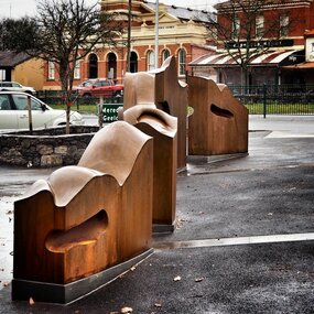
Artwork, other - Public Artwork, Cliff Burtt, Buninyong Bivium, 2016
Buninyong Bivium (2016) by Cliff Burtt engages with the geography and history of the Buninyong region in both pre and post settlement. The town of Buninyong is dominated by the profiles of Mt Helen and the extinct volcano Mt. Buninyong. Traditional land of the Wadawurrung people, today the area remains a significant site for the culture of indigenous people and their connection to the land. The profile of this sculpture is based on topographical mapping of the area, depicting sections of the landscape. The gaps between the elements of the work can be viewed as representations of the shafts sunk into the earth by the early gold miners and compound curves on the upper surfaces are mirroring the topography of the area, while cut-aways in the sides are suggestive of rock strata.The artwork is of aesthetic and social significance to the people of BallaratCorten steel sculpture made of five unique sculptural pieces secured to at concreate base at pavement levelbuninyong, cliff burtt, sculpture, public art, mining, ballarat -
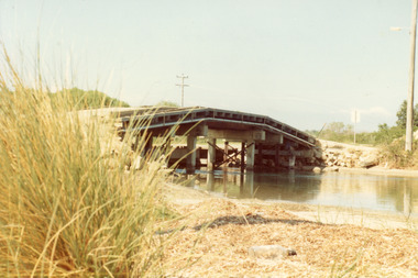
 Lakes Entrance Historical Society
Photograph, Lakes Post Newspaper, 1999
Colour photograph of the Cunninghame Arm Footbridge, . Lakes Entrancebridges, waterways, associations, topography -
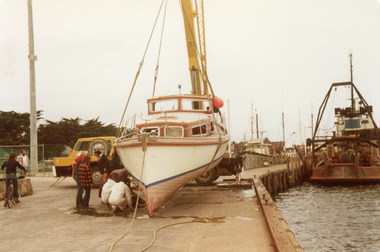
 Lakes Entrance Historical Society
Photograph, 1980
Colour photograph of the recovery of the cruiser Idler which had been abandoned at seatopography, fishing industry, ocean, boats and boating -
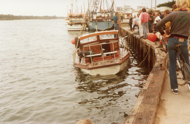
 Lakes Entrance Historical Society
Photograph, 1980
Colour photograph of the recovery of the cruiser Idler which had been abandoned at seatopography, fishing industry, ocean, boats and boating -
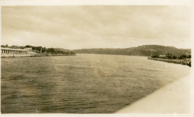
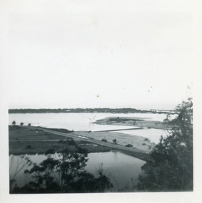
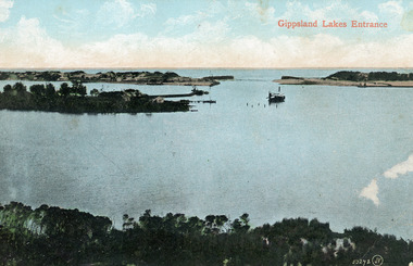 Lakes Entrance Historical Society
Photograph - The Entrance, 1910c
Colour tinted photograph of the entrance from Bass Strait to the Gippsland Lakes. It shows the small village on the hummocks, Bullock Island with bathing boxes at western end, machinery building groyne's from Bullock Island. Boat in the water. Lakes Entrance VictoriaGippsland Lakes Entranceislands, ships and shipping, topography, waterways -
 Lakes Entrance Historical Society
Postcard - Township, 1930c
Black and white small format postcard showing the township situated on the land between the Cunninghame Arm and North Arm. Lakes Entrance VictoriaLakes Entrance from Princes Highway (on back)bridges, township, topography, waterways -
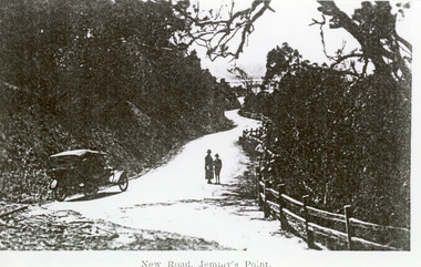 Lakes Entrance Historical Society
Photograph - Princes Highway Lakes Entrance, 1920c
Black and white photograph of the newly formed Princes Highway. It shows the steep cutting into the Jemmys Point hill, the winding road, the post and rail fence, two people and car of the era on road. Lakes Entrance VictoriaNew Road Jemmy's Pointtopography, waterways, roads and streets, fences -
 Lakes Entrance Historical Society
Photograph - S. S. Lady Harriet, 1908
1 x Black and white photograph copied from a book 9.5 x 14.5.Black and white photograph showing S S Lady Harriet at the cliffs on the Tambo river. The Lady Harriet barge on left of S S Harriet, well vegetated cliff behind the vessels. Swan Reach Victoria1908 S S Lady Harriet at cliffs in Tambo River and her barge (on back)jetties, ships and shipping, waterways, topography -
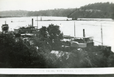 Lakes Entrance Historical Society
Photograph - New Works Jetty, 1910c
Also second black and white copy 9 x 13 cmBlack and white photograph showing lakes and boats at new Works Wharf. Some groyne work on Bullock Island on right, road cutting on Jemmys Point on right, Kalimna and Nungurner hills in background. Lakes Entrance VictoriaExcursion Boats, New Works Lakes Entrancejetties, waterways, boats and boating, topography -
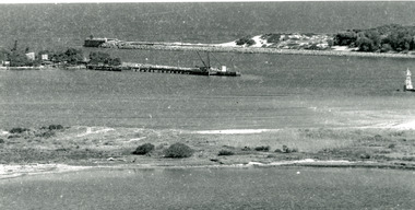
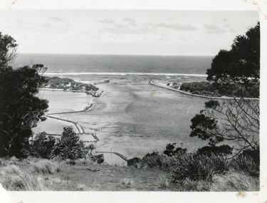
 Lakes Entrance Historical Society
Photograph - The Entrance
photograph showing entrance from ocean - Bass Strait into Gippsland Lakes , western pier on left side shows timber structure , tramline and crane . North end of eastern pier on right shows workshed and travelling crane and rubble wall. Mt Barkley in background Lakes Entrance Victoriawaterways, boats and boating, piers, topography -
 Lakes Entrance Historical Society
Photograph - The Entrance, 1920c
Copied from photograph in possession of J WhadcoatBlack and white photograph showing stone piers at entrance to Gippsland Lakes from ocean - Bass Strait. Eastern pier on left, dune and western pier on right. Cranes and some work sheds on left. Navigation light on tip of Bullock Island on extreme right. Lakes Entrance Victoriajetties, waterways, topography, township -
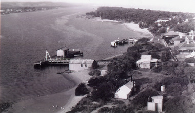 Lakes Entrance Historical Society
Photograph - New Works
Black and white photograph showing aerial view of Works buildings and cottages near man-made entrance to Gippsland Lakes Victoria boats and boating, topography, settlement, historic buildings -
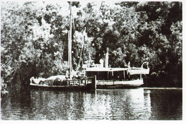
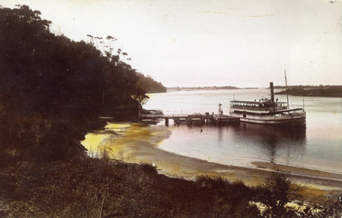 Lakes Entrance Historical Society
Photograph - S.S. Gippsland, 1925 c
Hand coloured photograph showing S S Gippsland leaving Kalimna Jetty. Small boats tied to far side of jetty, shed at left end of jetty. Jemmys Point beyond Kalimna, hummocks and the entrance in far background, point of Rigby Island on right. Kalimna beach in foreground. Lakes Entrance Victoriaships and shipping, topography, waterways, jetties -
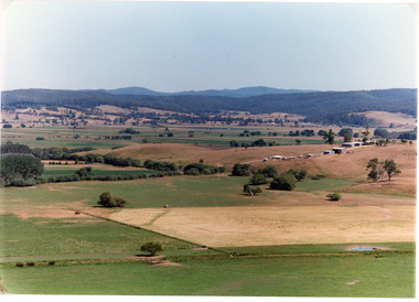 Lakes Entrance Historical Society
Photograph - Mossiface Flats, Tambo Shire, 1994
Also second identical copyColour photograph of the Mossiface Flats, near Bruthen, shows paddocks of the rich river flats, timbered foothills in the distance, with mountain range behind. Some paddocks have been mown for grass hay. Farm buildings in foreground and background. Dam in foreground. Bruthen Victoriaanimals, agriculture, vegetation, topography -
 Lakes Entrance Historical Society
Photograph - Bridges, Fish Marie, 1965
Also one other photograph, similar viewColour photograph of the first road bridge from Lakes Entrance to Bullock island, which was built for Public Works Dept. groyne building and sand build up to enlarge the island. Built early 1953. Lakes Entrance Victoria topography, bridges, islands, public works -
 Lakes Entrance Historical Society
Photograph - tramline Lake Bunga, Vogt, W S, 1920
Also one enlarged copy 20.5 x 28.5 cm|Also one copy 12 x 17|Also giant colour postcardBlack and white photograph showing view of Lakes Bunga, near Lakes Entrance. Tramline across lake shows beginnings of disrepair, one panel gone, another panel broken, two row boats on lake, larger one contains two adults and four children, smaller row boat has one small child. Entrance appears to be closed, thick vegetation around lake. Lake Bunga VictoriaLake Bunga (Northrope's), W S Vogt, Bairnsdalewaterways, topography, bridges, tramline -
 Lakes Entrance Historical Society
Postcard - The Entrance, Cooper Alexander, 1910c
Black and white large format postcard of the man made entrance to the Gippsland Lakes, it shows work in progress on the western pier of the entrance, Bullock Island, photo taken at low tide. Lakes Entrance VictoriaLakes Entrance Cunninghameislands, waterways, topography, ships and shipping -
 Lakes Entrance Historical Society
Photograph - Bullock Island, Fraser Ian, 1920c
Black and white photograph of Bullock Island, showing Prince's Highway from North Arm bridge, east end of Bullock Island and bridge, entrance to Bass Strait and sand dunes along Cunninghame Arm. Western end of Bullock Island bridge raised to allow small boats access to North Arm and Cunninghame Arm, became known as Humpy Bridge. Lakes Entrance Victoria islands, waterways, topography, bridges -
 Lakes Entrance Historical Society
Postcard - Bullock Island, 1920c
1 x Faded miniature postcard 6.5 x 8.5|1 x Black and white 9.5 x 12 copied from album in private hands|1 x Sepia toned 10 x 15|1 x Black and white 12 x 17.5Black and white small format postcard of Bullock Island. It shows the approaches to the concrete North Arm Bridge over North Arm, the footbridge to Bullock Island, the entrance to the Gippsland Lakes from Bass Strait and part of the township on the hummocks. Lakes Entrance VictoriaLakes Entrancewaterways, topography, islands, bridges -
 Lakes Entrance Historical Society
Photograph - Bullock Island, 1920 c
Black and white photograph of Bullock Island. Steamer J C D passing Western end of Bullock Island. Lakes Entrance VictoriaLakes Entrancewaterways, islands, topography, shipping -
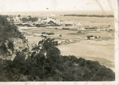
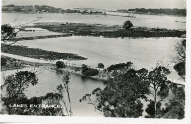
 Lakes Entrance Historical Society
Photograph - The Entrance, 1930c
Black and white photograph showing wooden piers at entrance to Bass Strait from the Gippsland Lakes. Buildings on sand dunes, Bullock Island and rock groynes. Photo taken from Jemmys Point showing shrubbery in foreground. Lakes Entrance Victoriawaterways, topography, boats and boating, islands -
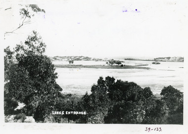
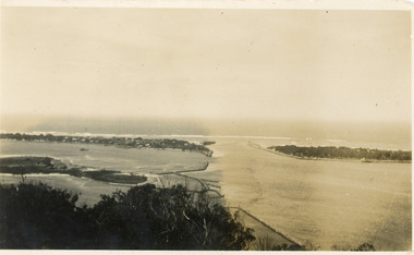 Lakes Entrance Historical Society
Photograph - The Entrance, 1930c
Black and white photograph showing wooden piers at entrance to Bass Strait from the Gippsland Lakeswaterways, topography, boats and boating, islands