Showing 14998 items
matching view
-
 Lorne Historical Society
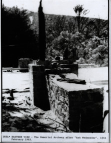
Photograph, Eastern View The Memorial Arch after Ash Wednesday 16/2/1983
Eastern View photograph of Ruins of the Memorial Arch after Ash Wednesday 16/2/1983eastern view. memorial arch, ash wednesday 16/2/1983 -
 Lorne Historical Society
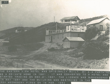
Photograph, Eastern View Hotel - Promenade Deck
Photograph of Eastern View Hotel promenade deck - hotel later destroyed in Ash Wednesday fireseastern view hotel; a.a. farthing; ash wednesday fires -
 Glenelg Shire Council Cultural Collection
Photograph, View of Portland Harbour and Port, c. 1971
Port of Portland Authority archives.Front: (no inscriptions) Back: verso - 'Portland Development Committee Publicity Section, Division of Industrial Development Reg no - 56-43.' -
 Ringwood and District Historical Society
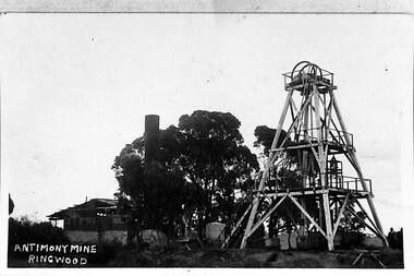
Photograph, View of the Ringwood Antimony Mine, buildings and headframe. C1900, c. 1900
The Antimony mine, set on top of a hill, was originally the centre for Ringwood development. The centre was relocated to the west around Ringwood station when the railway was built.View of the Ringwood Antimony Mine, buildings and headframe. A chimney from a smelter can be seen on the LHS. -
 Whitehorse Historical Society Inc.
Photograph, View through Schwerkolt's Orchard to Creek, Yarran Dheran and past Quarry, 1/02/1994 12:00:00 AM
Black and white photo of View through Schwerkolt's Orchard to Creek, Yarran Dheran and past Quarry.jamieson, norma, schwerkolt cottage -
 Old Colonists' Association of Ballarat Inc.
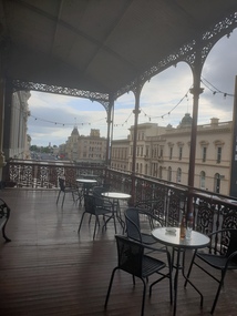
Photograph, Clare Gervasoni, View from the Balcony of the Ballarat Old Colonists' Hall Looking South, 2017, 23/03/2017
View down Lydiard Street North, looing south, from the verandah of the Old Colonists' Hall.ballarat old colonists' club, ballarat old colonists' hall, balcony, lydiard street -
 Buninyong & District Historical Society
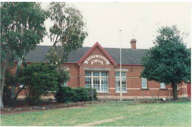
Photograph - Original Photograph, Clive Brooks, Buninyong Primary School, front (west) view, estab. 1893, 9 Nov. 1991
detail of historic buildingColour photo Buninyong Primary School, Ingles St., front (west) view, estab. 1893buninyong, holy trinity, tennis court, anglican, church, common school -
 University of Melbourne, Burnley Campus Archives
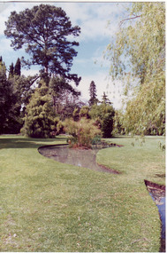
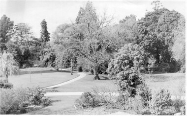
Photograph - Colour print, Garden View, 1991
Colour photograph. Garden view looking across the ponds towards the tree line with the Sequoia sempervirens.garden view, luffmann ponds, sequoia sempervirens, ponds, lily ponds, tree line -
 University of Melbourne, Burnley Campus Archives
Photograph - Colour print, Garden View, c. 1990
Enlarged colour photograph. Garden view from the Plant Research Laboratory towards the Administration Buildinggarden view, plant research laboratory, administration building -
 University of Melbourne, Burnley Campus Archives
Photograph - Black and white print, Garden View
Large black and white photograph in cardboard frame. View of Rock Point and the Lily/Luffmann/Pondsgarden view, rock point, lily ponds, luffmann ponds -
 University of Melbourne, Burnley Campus Archives
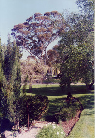
Photograph - Black and white print, Garden View, 1970
Black and white photograph. Garden view from the Administration Building looking towards the Sequoia sempervirens.garden view, administration building, sequoia sempervirens, californian redwood -
 Ballarat and Queen's Anglican Grammar School
b&w Photograph, Aerial view of Ballarat Grammar buildings
aerial view of school buildings with large trees along building line and hedge around propertyVerso - N. L. HARVEY (Press Photo Service) A.M.P. Chambers Lydiard St. N. 2996 pencilled on versoballarat-grammar, education, ballarat, wendouree, school -
 Buninyong & District Historical Society
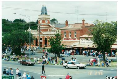
Photograph - Colour photograph, Buninyong Gold King Festival Feb.Feb.1995, view of Town Hall Precinct, Buninyong Gold King Festival Feb.Feb.1995, view of Town Hall Precinct
historic, mining, De Soza, Gold KingColour photo, Buninyong Gold King Festival Feb.Feb.1995, view of Town Hall Precinctmining, gold king, de soza -
 Ringwood and District Historical Society
Photograph, View along the bank of the Mullum Creek at the foot of New Street 1981
Written on back of photograph, "16/7/81. View along the bank of the Mullum Creek at the foot of New Street." -
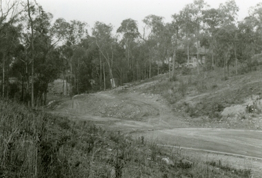
 Ringwood and District Historical Society
Photograph, View south-west over Debbie Place from below Pamela Court, North Ringwood 1982
Written on back of photograph, "1982 - View south-west over Debbie Place from below Pamela Court." -
 Ringwood and District Historical Society
Photographs, 1979-80 MMBW pipe line project at Hubbard Reserve, North Ringwood � View along line work in Hibberd's and Chalkley's
Part of a 43-photo record of the MMBW�s engineering feat in drilling a 12 inch pipe line up to 40 feet deep through rock hardened by volcanic action associated with geological fault that occurs along the line. The work took place from October 1979 to May 1980 on the southern boundary of Hubbard Reserve, North Ringwood. The collection was presented to the Ringwood Historical Research Group by J Clarke on 9th June 1980.E560 N27 Jan 1980 A43 View along line work in Hibberd's and Chalkley's (lot 9 and 8) -
 Ringwood and District Historical Society
Photographs, 1979-80 MMBW pipe line project at Hubbard Reserve, North Ringwood � View east, sewer work line showing grate over pit
Part of a 43-photo record of the MMBW�s engineering feat in drilling a 12 inch pipe line up to 40 feet deep through rock hardened by volcanic action associated with geological fault that occurs along the line. The work took place from October 1979 to May 1980 on the southern boundary of Hubbard Reserve, North Ringwood. The collection was presented to the Ringwood Historical Research Group by J Clarke on 9th June 1980.E560 N30 Feb 1980 A43 View east, sewer work line showing grate over pit -
 Ringwood and District Historical Society
Photographs, 1979-80 MMBW pipe line project at Hubbard Reserve, North Ringwood � View east up the gully
Part of a 43-photo record of the MMBW�s engineering feat in drilling a 12 inch pipe line up to 40 feet deep through rock hardened by volcanic action associated with geological fault that occurs along the line. The work took place from October 1979 to May 1980 on the southern boundary of Hubbard Reserve, North Ringwood. The collection was presented to the Ringwood Historical Research Group by J Clarke on 9th June 1980.E568 N19 13 May 1980 A43 View east up the gully, when all the work was finished -
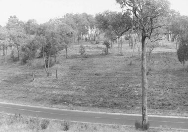
 Ringwood and District Historical Society
Photograph, View from Colemans Estate Heathmont, 1923. Near corner of Bedford and Canterbury Roads
Typed below photograph, "View from Colemans Estate Heathmont, 1923. Near corner of Bedford and Canterbury Roads". -
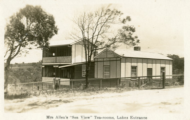 Lakes Entrance Historical Society
Postcard - Postcard/Seaview Tearooms, Bulmer H D, 1930c
Also enlargement 20.5 cm x 25.5 cm with inscription Mrs S G Allens Sea View Tea Rooms, Lakes Entrance 01346.1Black and white postcard showing the Sea-view Tea-rooms, lattice veranda, two-storey building to face the view, photographs of dining room, and outside view. Lakes Entrance VictoriaMrs Allens Sea-view Tea-rooms, Lakes Entrancerestaurant, local history -
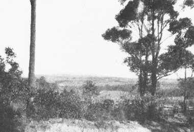
 Ringwood and District Historical Society
Photograph, View towards Loughnan's Hill overlooking Maroondah Hwy Ringwood from around Braeside Avenue area
Typed below one photograph, "View towards Loughnan's Hill from Harrison St. 1946". Written below another copy, "Loughnan Hill from Andrew St. 1946". both incorrect - view overlooking Maroondah Hwy from around Braeside Avenue area. -
 St Kilda Historical Society
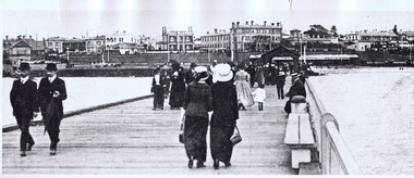
Photograph, St Kilda Pier. View of Esplanade from Pier 1915-16, c. 1915
black and white photograph (a copy?)Inscription: View of Esplanade from Pier 1915-1916. Melbourne - Suburbs - St Kilda. View of Esplanade from the Pier. St Kilda by the Sea Annual, p.21. Season 1915/16. F600:65. Stamped National Library of Australia, Canberra. H 76 -
 Lorne Historical Society
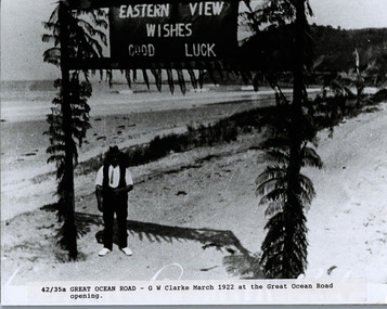
Photograph, G.W. Clarke with banner at Eastern View
Photograph 1922 of Mr G.W. Clarke under a banner reading " Eastern View Wishes Good Luck" g.w. clarke; 1922: eastern view wishes good luck banner; -
 Eltham District Historical Society Inc
Photograph, View north east from Porter Street, Eltham, 1994, 1994_
Colour photograph of view north east from Porter Street, Eltham near Ely Street, 1994porter street, eltham -
 Buninyong & District Historical Society
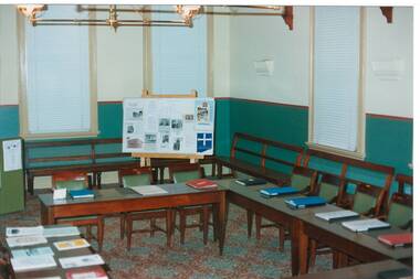
Photograph - Original Photograph, Mr. C.J. Brooks, Interior Buninyong Courthouse, view to NE corner, November 1995
Social/ political, legalColour photo, Interior Buninyong Courthouse, view to NE corner showing tables, benches and display board.buninyong, courthouse, buninyong council chamber -
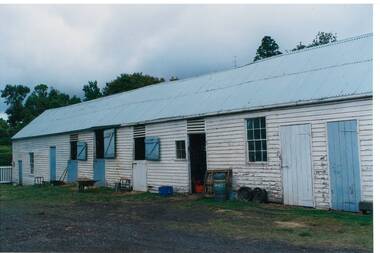 Buninyong & District Historical Society
Photograph - Original Photograph, Clive Brooks, Part view of old stables at Mount Boninyong Homestead, 9/11/1991
historic buildingColour photograph, Part view of old stables at Mount Boninyong Homestead, white weatherboard, blue doors.buninyong, mt. boninyong hopmestead, stables, scott -
 University of Melbourne, Burnley Campus Archives
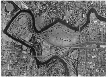
Photograph - Black and white prints, Aerial View of Burnley Campus, 1963-1970
Freeway was not begun until 1968.Black and white photographs. Aerial View of Burnley Campus. (B) Original of (A). Enlargement (C) Laminated copy(A) Inscribed on reverse, "South Eastern Freeway 9.7.63 R22.024.439." (C) Paper attachment: The Burnley College Portion of Richmond Park in 1972. Swan Street Takes Its Familiar Route. The Boulevard Has Been Constructed. The Golf Course is in Place. The Series of Parallel Buildings Along the Railway Line at the Bottom of the Photo Are the Poultry Sheds Used For Egg-Laying Competitions. Burnley Sidings Were Still to be Built. In the Mid-1990's Much of the Western Portion of the College Grounds/Richmond Park Was Sold.burnley campus, aerial view, south eastern freeway, richmond park, swan street, yarra boulevard, richmond golf course, poultry sheds -
 University of Melbourne, Burnley Campus Archives
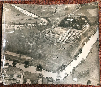
Photograph - Black and white print, Airspy, Aerial View of Burnley Campus c. 1925, c. 1925
TH Kneen and EB Littlejohn note that the Principal's House has been extended. This was done for J P McLennan, Principal 1917-1921. Note "Bird Cage" in Orchard, dwarf fruit trees, shed where tobacco was stored. Photo taken before Plant Research Institute was built in 1929. Photo shows there had been cultivation outside the College grounds, beyond the orchard area and hedge.Colour photograph of black and white photograph. Aerial view of Burnley Campus. Cultivation outside Burnley Campus burnley campus, principal's house, jp mclennan, bird cage, orchard, dwarf fruit trees, plant research institute, principal's residence, tobacco storage sheds, cultivation outside campus -
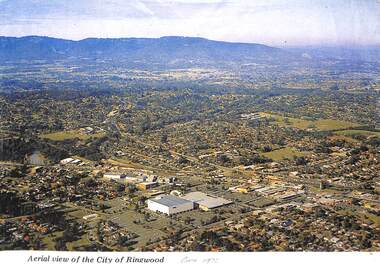 Ringwood and District Historical Society
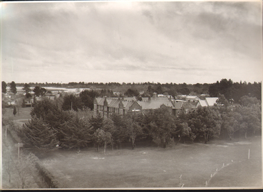
Photograph, Aerial view of the City of Ringwood - Circa 1972
Coloured photograph"Written on face of photograph" Aerial view of the City of Ringwood showing Eastland (stage 1), Ringwood High and Technical Schools. -
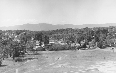 Ringwood and District Historical Society
Photograph, View from Ringwood Civic Centre. East Ringwood oval can just be seen - 1973
Typed below photograph, "A view from Ringwood Civic Centre. East Ringwood oval can just be seen - 1973."