Showing 1004 items
matching w north
-
 Glen Eira Historical Society
Book - Christ Church, Ormond (Anglican)
The Christ Church Chronicles; 1901 – 2001: A presentation of Christ Church, Ormonds history for its centennial celebration, By Vi Manson. A detailed history of Christ Church Ormond, including the church building, vicars, the church community, furniture, organ and bells, societies and fellowships, social groups and youth groups, music, choir, sporting groups, social history, (e.g. fashion, transportation) role of church in the community, missionary work. Includes a list of vicars and long - serving parishioners. Includes black and white photos (36mm x 43mm – 165mm x 116mm).haste victor rev, laidlay w. w. rev., hamilton karl rev., connelly jim rev., cheong geoff rev., cooling w. r. rev., tunstall denise, mitchell e. (ted) rev., raymond c. h., zammit catherine, brown stan rev., williams r. h. b., durance ronald rev., backhouse walter rev., fullard leonard, dunlop julie, hewton mrs., dryden albert, laby beth, n’diaye maree, parker lorraine, seymour gary, sayce val, jackson nell, winn alan, mollison don, anderson bruce, savage jennie, clay cynthia, grant warwick, martin jon, ingamells phillip, ingamells hope, hewton d. r., phillips w.a., brewer c. a., martin w. perry, robinson e. e., thorp h. j., harvey e. a. c., coish c. j., huggett b. d., simpson m. j., holt wilfred, poole tony, wardrop george, stone ron, north road, wheatley road, katandra road, manson vi, religious groups, morrison bill, christian bob, drumond jack, downham elise, king rita, mollinson ada, baxter edna, baxter ted, bebbington arthur, collinson ed., grant gladys, grant alec, holt betty (geer), holt kath, ingamells fred, rivers pam, thompson merle, choirs, organs, anglican church, sunday schools, tennis clubs, depression 1929 – 1939, world war 1914 – 1918, clergy residences, bells, cemeteries, youth clubs, sport, libraries, camping, newspapers, ormond, christchurch ormond, anglican christ church ormond -
Glen Eira Historical Society
Document - Elsternwick Congregational Church – Caulfield Union Church
Souvenir programme of the Elsternwick Congregational Church Welcome Home Social for their members, who served in World War 1, held on 05/05/1919 at the church. Includes a photograph of church exterior. A programme for the Combined Welcome Social for the new pastor Rev. J.S. Griffiths held on 09/12/1919. The twenty-seventh annual report of Elsternwick Congregational Church for year ending 30/06/1921. Pamphlet for jubilee celebration for Elsternwick Congregational Church in August 1944. Includes programme of events and brief history of the church. Programme for fifty-first church anniversary and social held on 12/08/1945 and 15/08/1945. Undated church letterhead sheet of paper. Includes exterior photograph of the church. Four church newsletters from March 1973, March 1975, February 1977 and May 1977. Three black and white photographs, undated and photographer unknown, of church exterior, Pilots’ Club and Sunday School children.elsternwick congregational church, world war 1914-1918, butters r.w., elliot t., hale w.r., christiansen a.l.a., thoms f.e., emmerson j.h., angwin h.h., white s.j., anderson g., wragge l.g., adams g.h., smith e.j., thoms s.e., anderson j., wragge t.w.e, emmerson e., cleghorn h., lindsay g.j., fullagar w.k., barker j.n., snowball g.f., clarke r., wragge s., joynes a., lewis r., griffith j. shaw rev., griffith mrs., bryant samuel rev., christiansen w. rev, slatter j.c., robertson w., clarke w., forward f.a. rev., orrong road, king street, curral road, hoddle street, elizabeth street, robertson r.j., pedler b.r., hoare j.g., lewis g.n., tytherleigh r. j., watts v., message h.t., barlow c.w., northey j.d. rev., krohn f.w. rev, swan e.f.w. rev., riddles f.j. rev., elsternwick, caulfield north, hatley l., hatley l. mrs., parkside street, langdon bob rev., bendelack i., sandham court, mcloghlin j.r., prahran grove, smitham nancy, religious groups, sunday schools, congregational church, newsletters, st. john’s uniting church elsternwick, strickland a. mrs., watts w.c. mrs., mcivor miss, watts t. mr., watts t. mrs., watts r. miss, anderson a. mr., white miss, white c. miss, white p. miss, gladman f.e. mr., glandman f.e. mrs., slatter h.t. mr., slatter h.t. mrs., boldner a. mr., boldner a. mrs., smith s.a. mrs., strickland a. mr., owen w. mr., owen w. mrs., woodward t. mr., gregson j.b. mr., shippey f.l. mr., turner c. mr., turner c. mrs., blanch j.w. mr., blanch j.w. mrs., pye h. mr., pye h. mrs., haynes m.j. mrs., burgess e. mr., burgess e. mrs., watts h. g. miss, burgess a.s. mr., burgess a.s. mrs., watts m. miss, thoms w. mr., thoms h. mr., thompson j.m. mrs., thompson miss, grover e. miss, slatter h.h. mr., slatter r. miss, anderson a. miss, thoms e.m. mrs., newson m. mrs, legge mrs., legge f. miss, legge b. miss, young mrs., young miss, copland o. rev., copland o. mrs., steed mr., steed mrs. -
Glen Eira Historical Society
Letter - Ormond Baptist Church
Handwritten article by unknown author with church foundation stone inscription details, correspondence to Mr. Wells dated 23/07/1977 from Deacon Peterson regarding enclosed copy of Ormond Baptist Church history. Two real estate articles, including sketch, of property for forthcoming availability to lease property dated 22/04/2003 and 15/12/2003.ormond baptist church, walsh street, lillimur road, foundation stone, smith a.e. rev., warner l.e., architects, firth r., builders, peterson r.h., lord’s real estate, fullard charles, ormond, glenhuntly, glen huntly, mcdonald s.a. rev., elsternwick, mckinnon, ellingworth w.h.g., home missionary society, elsternwick baptist church, fullard c., fullard mrs., youl w.e., youl mrs., lever j., lever mrs., lowry miss, gollan i. miss, bowcher miss, douse mr., douse mrs., brooks mrs., brooks j., glenhuntly state school, lillimur road, probert e., sunday schools, drummond a., drummond mrs., ratcliff w.h., holloway w.h., bungey e. rev., cross w. rev., bentleigh church, hinton w.h. rev., collard w. rev., whitbourn l.j. rev., donaldson street, mckinnon, wells mr., peterson rev., north road, lord john, lord’s, estate agents -
 Glen Eira Historical Society
Article - St. Andrew’s Presbyterian Church, North Road, Gardenvale East
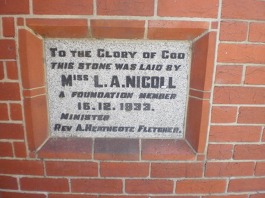
Handwritten document giving brief details on wording on foundation stone of St. Andrew’s church, undated and author unknown. Photocopy of pamphlet produced for the stewardship campaign 1957 for St. Andrew’s Presbyterian Church Gardenvale East, with several photos. It includes history as well as current situation at 1957. Photocopied notes and photo of the Army Hut used by Gardenvale Primary School in 1921 only as donated by church for and year then Reverted back to church use. Photocopy of letter to Glen Eira News and City Council re-proposed subdivision of church land from Robert W. Sinclair.st. andrew’s presbyterian church, foundation stones, nicoll l.a., heathcote-fletcher a. rev., north road, seach street, smith a. f.h. rev., mcneilage alex rev., gardenvale east, caulfield south, younger street, gardenvale east church, nicholls rev., rowlands w. rev., lang walter, sunday schools, yeaman f.e. rev., brown f.e., brick, towers, manse, choirs, groups, smith mrs., curtis e.e., morse roger, marryatt harry, pegler adrian, savill t., south caulfield, gardenvale primary school, sinclair robert w., dakin ms., campbell felicity -
Glen Eira Historical Society
Article - St. Catherine’s Church of England, Kooyong Road, Caulfield South
Three items about this Church: 1/St. Catherine’s Parish paper, February 1924. 2/Baptismal prayer card for Harry Norman Bromfield 08/03/1925. 3/Carbon typed copy of document detailing inscriptions in St. Catherine’s Anglican Church Caulfield.st. catherine’s church of england, st. catharine’s church of england, caulfield south, kooyong road, clarence street, stephens mr., debb dr., murphy mr., booth e., masters p., kindergartens, paterson mrs., fowler mrs., capper mrs., mayes mrs., olley mrs., hosken mrs., schwieger miss, walker mrs., ward mrs., foster mrs., marshall mrs., marsh mrs., hearn miss, stephens h., downshire road, bromfield harry norman, taylor alice mary, wigg catherine elizabeth, stephens grace m., beagley emily a., beagley joseph e., beagley emily ada, parrott frances catherine, wilson alfred roscoe, hamilton flora, hillard john beattie, hillard thomas, haillard eliza, barlow w., begbie a.h., cole s., love j., north h., tonks h., scammell s., hunt geoffrey donald, myer leslie robert irvine, forbes betty, mcavoy alan robert, humphreys betty grace, marke alfred robert, bromfield norman edward, reed margery eva, philpot elizabeth ann, dillow henry thomas, murphy mr., taylor mr., booth mr., drewett mr., hickson mr., ingram mr., lumsden mr., meyer mr., nutt mr., summerhayes mr., mcclure j., segal boris -
Glen Eira Historical Society
Newsletter - Helenslea, Shelford|CEGGS
A photocopy of a two page article from the St Mary’s Church Chronicle of 16/12/1922, documenting the purchase of Helenslea by the Shelford School for St Mary’s Church. The article gives the deposit, price and background to the purchase, a brief description of the purchased building and planned alterations and also makes an appeal for funds. The article includes a black and white photograph (88mm x 154mm) of the exterior of Helenslea.shelford school, hood crescent, st mary’s church, caulfield north, st mary’s church chronicle, caulfield north, graham j moffitt, swale d h, smith sydney, smith ogg and serpell architects, dodgson miss, eggleston f w, falls mr, prendergast a l, slaney f, dumas mr, pollard mr, blundell miss, gill miss, beggs f g, beggs c, head mrs, hollow s, irwin t, lloyd m c, graham j m, eggleston f w, frederickson mrs, langley canon, askew a i, scales a w, dixon emily, glen eira road, blundell dora, seymour road, stephen george sir, douglas sholto, hood justice, ludbrook e c, helenslea, allison road, schools -
Glen Eira Historical Society
Document - Helenslea, Shelford CEGGS
Four photocopies of a one page article from the Shelford Magazine of 06/1928 which gives a short history of Shelford and its association with Helenslea Mansion and St Mary’s Church and an enrolment history from 1922 to 1928. The article includes three black and white photographs (45mm x 70mm) of the exterior of Shelford in 1898, 1905 and 1922.homan freda, thomas miss, seymour road, glen eira road, palmer w e, palmer w e mrs, dixon emily, blundell d, langley canon, helenslea, st mary’s church, shelford, hood crescent, st margaret’s hall, ripley grove, caulfield north, shelford magazine, schools -
Glen Eira Historical Society
Document - Kooyong Road, 110, Caulfield North
Copy of typed letter 27/05/1989 from Brighton Historical Society giving details of history/owners/tenants of 110 Kooyong Road, Caulfield North from 1840 to 1985. Accompanied by handwritten working notes naming owners/tenants of property 110 Kooyong Road, North Caulfield from 1936 to 1985. House was built in 1936.kooyong road, rosemont farm, howitt godfrey dr, settlers, caulfield north, howitt alfred, henderson garnet w., henderson m.m. miss, haskin joseph, anstee w.e., holst edward, bullock hilary, landells rosalind, land subdivision -
Glen Eira Historical Society
Plan - Nettalie
An A4 photocopy of the 'Plan of the Caulfield Road District' dated 1867. This plan shows the location of the properties owned by A Shaw and Blundell on Balaclava and Orrong Roads where Nettalie is situated. The plan includes all the landowners listed where their property was, the street names and other landmarks of 1867 including railways, hotels and reserves.caulfield, caulfield north, elsternwick, st kilda east, parish of prahran, parish of moorabbin, caulfield road district, melbourne and brighton railway, rosstown railway, elsternwick railway station, caulfield railway station, rosstown railway station, murrumbeena railway station, baptist church, paddy’s swamp reserve, cemetery reserve, leman swamp reserve, caulfield racecourse reserve, brighton cemetery, the vine caulfield hotel, the tam o’shanter hotel, melbourne hunt hotel, royal hotel, hotham street, horne street, nepean highway, north road, orrong road, dandenong road, princes highway, kooyong road, alma road, inkerman road, balaclava road, glen eira road, glen huntly road, hawthorn road, cemetery road, bambra road, redan road, kambrook road, neerim road, booran road, racecourse road, grange road, koornang road, murrumbeena road, crosbie road, kangaroo road, poath road, ford w, lempriere, cople j, riddell j c, manifold j, testar t, billing r h, semple, blundell, shaw a, butchart g, stephen j w, stephen g sir, hart j, duncan g, blackie r, stephen f, mccombie t, woollaston h, higgins j, lloyd j c, daish j, mcleod j, hughes d, wilson a, jamieson g, webb g h, renwick s, pennington h, dunn j, kirkpatrick w, ricketson w, toad a, sayce j, watts t, widgery, store, guess j, anketell j, clack j, sissen w, clayton g, dickson d, bevan j, hart t, anderson j, hart mrs, webb h, masters s, waghorn j, hemming c, hiam c, farquhar w, newing t, payne t, cooper r, snipe s, chambers j, forster w, summers r, harriman b, warrick, o’connell, long j, peck r, cochrane c, murray ross w, evans c, kennedy j, maclean n, forster, lyall w, dean j, newton h, looker w, baker c, johnston, crosbie j, kerr, jones, parr, nelson c, montgomery l, parsons w, james j c, sibon c, smith sydney w, plans, maps, land subdivisions, land use, settlements, roads and streets, hotels, churches, police stations, post offices, land surveys, railway stations, railways, schoolhouses, commerce, clergy residences, official buildings, local government, road districts -
Glen Eira Historical Society
Document - FAIRFIELD HALL, NORTH ROAD, 225, CAULFIELD SOUTH
A two page document, dated 31/05/1981, from the Brighton Historical Society, written by Rosalind Landells, about Fairfield Hall. The document provides a brief history on Fairfield Hall, describes the surrounding area, provides details of buildings architectural features, and gives information about the house’s occupants and additional details about the occupants the Younger family.fairfield hall, north road, caulfield, caulfield south, elsternwick station, gardenvale station, lantana street, begonia street, magnolia street, younger family, younger alex, norris william, landells rosalind, leadlights, curwen frederick w, hawthorn black brick, architectural features, tuck pointing, tessellated tiles, verandah, towers, rudd e w, hurley, knight c p, manala, wall harry, warrein road, wall hounsell, younger a m, younger john, kenya, younger a m mrs, campbell h a mrs, campbell hugh, younger jeanne, gardenvale, younger avenue, younger’s avenue, fairfield grove -
 Glen Eira Historical Society
Caulfield Properties
Photograph of Labassa formerly Ontario, built for A. W Robertson, date unknowncaulfield north, manor grove, mansions, labassa, ontario, robertson, a. w -
 Glen Eira Historical Society
Caulfield Properties
Photograph of Merton, residence of J. W. Stephen, circa 1880caulfield north, avoca grove, merton, mansions, stephen, j. w -
 Eltham District Historical Society Inc
Folder, Personal papers of Stanley Simpson Addison M.B.E
Contents: Eltham War Memorial Trust, Official Opening - Baby Health Centre, 15th November, 1952; Timetable of proceedings Eltham Baby Health Centre; Official Opening - Baby Health Centre: Address by President, 15 November 1952 Program; Eltham War Memorial Trust: Opening of the Second Unit of the War memorial, The Pre-school Centre, on Saturday, December 1st, 1956 at 3 p.m. Eltham War Memorial: Address by Mrs Stanley Addison at the Annual Meeting of the Infant Welfare Centre, Thursday 21st October, 1965 Newspaper clipping: Infant Welfare Centre as War Memorial, 15 November 1952 Newspaper clipping: Eltham War Memorial Trust by Stanley Addison, 1953 Newspaper clipping: Eltham: Memorial Baby Health Centre Opening Newspaper clipping: Minister to open Eltham Pre-school Tomorrow Newspaper clipping: War Memorial Trust Who is this man? By Stanley Addison (M.B.E., B.A., B.Sc., J.P.) Stanley Simpson Addison biography (b. 14/10/1880 d. 1/1/1972) Eulogy: Stanley Simpson Addison (14 Oct 1880-1 Jan 1972) Photograph: Stanley S. Addison, B.Sc., The Australasian Intercollegian, April 1, 1916 Letter, Eltham High School Advisory Committee re pending retirement of Cr. Addison from the Eltham Shire Council, 8 June 1956 Behind and Before by Stanley S. Addison, The Way, September 1956, pp 6-7 Newspaper clipping: Eltham Shire's President is Cr. S. Addison, Heidelberg News, Friday September 12, 1952 Newspaper clipping: Mr S. Addison Honored, Heidelberg News, Friday September 21st, 1956, p13 Additional information about Stanley Simpson Addison from Bill Glasson, 15 March 2014 Additional information about Stanley Simpson Addison's Naval Service record and MBE (National Archives) Opening of Lower Plenty Memorial Chapel, 30 November 1952 Letter from Brigadier H.H. Hammer, HQ 2 Armed Brigade to Cr. S. Addison, President, Shire of Eltham giving thanks for Coronation Celebrations parade support, June 1953 Newspaper clipping: Eltham President's Advance Programme Newspaper clipping: Coronation Festivities; Eltham Shire President's Notes Newspaper clipping: Hurstbridge: Coronation Day Ceremony Draft of letter by Stanley S. Addison, President, Kangaroo Ground Advancement League regarding electricity connection for Kangaroo Ground - Panton Hill, 1954 Electricity connection, Kangaroo Ground - Panton Hill, 1954 Electricity connection, Kangaroo Ground - Panton Hill, 1955 Newspaper clipping: Light for Diamond Valley; Kangaroo Ground and Panton Hill, Friday 20th May, 1955 Electricity connection, Kangaroo Ground - Panton Hill, 1955 Electricity connection, Kangaroo Ground - Panton Hill, 1956 Electricity connection, Panton Hill - Smitrhs Gully, 1958 100th Anniversary Services, Kangaroo Ground Presbyterian Church, 17 March 1957 Early History of Kangaroo Ground compiled by Neville Haughton in March, 1959 Newspaper clipping: Eltham Community Chest, Heidelberg News, 12 September 1958 Newspaper clipping: Proposed Eltham Community Chest by Stanley Addison, Heidelberg News, 29 January 1959 Newspaper clipping: Community Chest With Wider Objectives, Heidelberg News, 5 February 1959 Newspaper clipping: Community Chest for Eltham, 1959 Newspaper clipping: Council Protest on Community Chest, c.1959 Newspaper clipping: Community Chest Outlined at Small Meeting, c.1959 Newspaper clipping: Treasure in the Diamond Valley by Stanley Addison, Heidelberg News, 19 February 1959 Newspaper clipping: Diamond Valley Chamber of Commerce, c.1959 Approx. 89 pages of varying types; photocopies, newsclippings, hand written notes, invitations, lettersa.c. ring, a.s. davis, adult education, biography, brigadier h.h. hammer, centenary celebrations, coronation, d. dureau, d. scales, d.a. lyon, d.s. pepper, diamond creek, diamond valley chamber of commerce, diamond valley community hospital, electricity supply, eltham chamber of commerce, eltham community chest, eltham high school advisory committee, eltham high school, eltham infant welfare centre, eltham pre-school, eltham shire council, eltham war memorial trust, eulogy, f.f. durham, f.h. buckwell, f.v. squire, g.c. waring, g.w. smith, h. thompson, h.f. thorpe, j. north, j.l. ryan, j.r. stuber, j.w. burgoyne, j.w. middleton, k.w. smith, kangaroo ground advancement league, kangaroo ground presbyterian church, kangaroo ground, l.r. bassett, lower plenty memorial chapel, miss j. humphreys, montmorency girl guides, montmorency tennis club, montmorency, mrs. b. harrington, mrs. stanley addison, n.h. baxter, opening ceremony, panton hill, parade, r. t. harrap, r.s. leeson, s.a. hick, shire president, smiths gully, st faiths anglican church, stanley s addison collection, stanley simpson addison, stevenson family, vera addison (nee staley), vera addison, w. stephenson -
 Marysville & District Historical Society
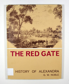
Book, The Red Gate-A History of Alexandra, 1969
A history of AlexandraHardcover. Front cover of dust jacket has a drawing of old Alexandra.Stamp of Marysville & District / Historical Society Inc / P.O. Box 22 / Marysville 3779alexandra, north east victoria, victoria, australia, history, gerald w noble -
 Marysville & District Historical Society
Book, The Red Gate-A History of Alexandra, 1969
A history of AlexandraHardcover. Front cover of dust jacket has a drawing of old Alexandra.Stamp of Marysville & District / Historical Society Inc / P.O. Box 22 / Marysville 3779alexandra, north east victoria, victoria, australia, history, gerald w noble -
 Bendigo Military Museum
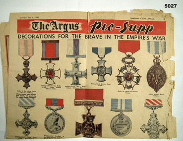
Newspaper, The Argus News, The Argus - Picture Supplement, 6 July 19940
This is a single sheet of newsprint, when folded makes four pages. It is marked pages 5,6, 11 & 12, It has photos in B & W. The front page (5) is in colour, it is of British Gallantry medals. At the bottom of front page are 3 enhanced B & W photos - aeroplanes, tanks & ships. The last page has a coloured map of the British Isles, with a bit of the North Sea and a bit of France.ww2, british empire -
Federation University Historical Collection
Letter, Inward Correspondence to the Ballarat School of Mines, 1910, 08/1910
Inward Correspondence to the Ballarat School of Mines, August 1910letterhead, education department, gordon, c. brennan, l. eddy, state forests commission, edwin feild, royal victorian institute of architects, the steel company of australia, james martyn, clarke & co, ludwig alberti, scarsdale, thomas m. jude, justinian oxenham, clara davidson, robert davidson, j. roberts, h.b. silberberg & co, l. gilbert, macquarie steam brick yards, james dewar, r.j. flowerday, staffirdshire reef, john wilesmouth, bank of new south wales, victoria silicate brick company ltd, t.s. huggins, george f. roughhead, federal store, legislative assembly, andrew mckissock, city of ballarat, r. e. williams, ballarat school of mines battery assistant, edgar c. hurdsfield, bairnsdale school of mines, w. kingston, gordon technical college, h.l. langdon & co., felton grimwade, f.f. brunn, bendigo school of mines, gold buyers bill, chaffey salmon & dunne, h.j. thwaites, cobar, henry leahy, h. blyth, s. radcliff, archie buchanan, launceston, fairthorne and sons, sloanes and scotchmans united quartz mining company, james eton, albert bradford, 109 lyons st north -
 Bendigo Military Museum
Photograph - PHOTOGRAPH AND LEGEND, Pre war - 1941-42
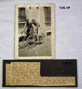
The two cyclists were taken prisoner in North Africa. The prisoners gave the photo to Colin Odlum and the result was that the photo came back to Australia and given to William (Billy) Bird who loaned the photo to the Cycling Club in Bendigo. Colin Odlum VX45898 2/23 Batt AIF. KIA 12.7.42. Refer 127.56, 128.2, 137.3P. Bettie Bird refer 136.2, Billy Bird 1601. .1) Photo, B & W of two Italian men on Racing Bikes with building in the background. .2) Original newspaper article re Italian POW's and Colin Odlum on a black background. .1) On the rear faded writing re the two cyclists "POW's"documents, historical notes, photography, photographs, military history -
 Bendigo Military Museum
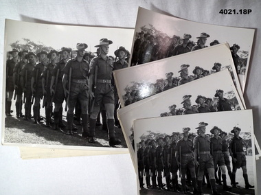
Photograph - PHOTOGRAPHS, MILITARY, 1960 - 61
(.1) The attached sheet in brief. The parade is being inspected by the Premier of the State of PERAK, Mohammed GAZALI BIN JAWI, the troops are 1 RAR marking the end of the successful battle against the Communist terrorists in the south and central Perak north Malaya. A number of the soldiers are named. (.9) The same parade as (.1) with a number of soldiers named in the fore front. The photos relate to the collection of Francis William (Dinky) DEAN BEM, VX93960 2nd AIF, 3742 1 RAR 1943 - 1975. Refer Cat No 124.2 for his service details.All photos are B &W. (.1) A parade of Australian soldiers being inspected by a foreign dignitary. Attached to the photo is a typed paper with detail of the proceedings. (.2 - .8) Same photo as (.1) smaller without the attached details. (.9) A parade of Australian soldiers in 3 ranks, attached to the photo is a typed paper with detail of the proceedings. (.10 - .18) Same photo as (.9) smaller with out the attached details.On the rear of (.1 - .8) stamped in purple. “Public Relations Australian Army Force GHQ FARELF GUN 63 MC” On rear of (.9 - .18) Has the same as above except the GUN No is 64.photography, military, malaya -
 Bendigo Military Museum
Letter - AUSTRALIAN MILITARY FORCES LETTER, 26.2.1920
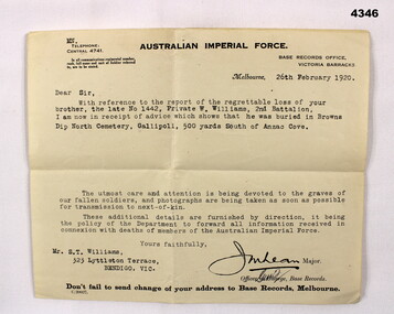
The letter to Mr Williams relates to the burial of No 1442 Pte W. Williams 2nd Bn AIF and is burial place “Browns Dip North Beach Gallipoli 500 yards south of ANZAC Cove. Refer Cat No 4342P for his service details also Cat No 1859P for medals and photo.Australian Imperial Force Official letterhead, light cream coloured, typing in black relating to the loss of Pte W. Williams and his initial burial on ANZAC.Typed in black, “Mrs S.T.Williams 323 Littleton Terrace Bendigo Vic”letters, graves, burial, anzac cove -
 Bendigo Military Museum
Equipment - PROTRACTOR, SQUARE
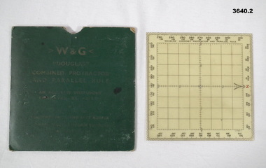
Item re Frederick Gardner DAVEY DFC No 410533. Refer Reg No 3536P for his service details. Used in map reading & air navigation. .1) Square green coloured card pocket for storing protractor / rule. Instructions for using the protractor / rule printed on reverse of pocket. .2) Combined protractor & rule. Square clear plastic with degrees markings around the outer edge. North marked in red. Centre area gridded in one centimeter squares..1) Printed on front: W & G DOUGLAS COMBINED PROTRACTOR AND PARALLEL RULE .2) Handwritten in pencil on back: 410533 DAVEY F.G.navigation, maps, equipment -
 Federation University Historical Collection
Book - Diary, John Kennedy, John Kennedy's Ballarat School of Mines Lecture Notes, 1889
John Kennedy was born on 04 April 1862, the son of ship carpenter Robert Kennedy and his wife Florinda (Aitken), and the brother of Malcolm and Colin Kennedy. In 1860 the family migrated to Melbourne where Kennedy senior set up as a shipwright. In 1879 Malcolm and John, who trained as a naval architect, joined their father as Robert Kennedy & Sons, shipbuilders and shipsmiths. On 27 December 1883 at North Melbourne, Malcolm married Ann White with Presbyterian forms. Next year Robert Kennedy & Sons removed to Hobart where with John W. Syme and W. J. Duffy, partners until 1889, they took over the Derwent Ironworks & Engineering Co., a foundry formerly owned by the (Alexander) Clark family. The Kennedys also acquired the patent slipyard, formerly Ross's, at Battery Point. After the shipbuilding industry in Hobart began to flag John also turned to mining: he attended the Ballarat School of Mines, and reopened the Hobart smelters which had been an adjunct of the Derwent Ironworks in the 1870s. He made several voyages overseas on smelting business and as mining promoter, and was a member of the London Stock Exchange. In 1913-14 he was manager of Tongkah Compound (1910); Robert Kennedy & Sons was reputed to have contributed to the success of the Hobart-run Tongkah Harbour, Thailand, tin mines by developing a suitable dredge. The brothers also held shares in the Irrawaddy Burma Co. John was a member of the Australasian Institute of Mining Engineers and from 1932 an honorary life member of the American Institute of Mining & Metallurgical Engineers. John died in Hobart on 10 January 1937. (Ann G. Smith, 'Kennedy, John (1862–1937)', Australian Dictionary of Biography, National Centre of Biography, Australian National University, http://adb.anu.edu.au/biography/kennedy-john-7092/text11963, published first in hardcopy 1983, accessed online 24 April 2020.) A book covered in black leather with 'John Kennedy' embossed on the front in gold. The book contains notes from the time he studies at the Ballarat School of Mines. The beginning of the book has an alphabetical section where John Kennedy has created an index.Inside front cover 'John Kennedy Nena Wharf Hobart Tasmania.' john kennedy, australasian institute of mining engineers, ausimm, american institute of mining metallurgical engineers, ballarat school of mines, lecture notes, lecture notebook, antinomy, brick clay, carbon, coal, copper, chemistry, clay, chrome, electricity, fire clay, gas, gold, gold bullion, glass, gold test for, iron metallurgy, light, lead, metallurgy, mica, mineralogy, pyrites, sulphur in pyrites, sugar, slags, wolfram, preparation of pure gold, scorification, gold bullion assay, petrography, melting poinys of bodies, metric system, geology, mount morgan, queensland, rock salt, assay of tailings, classification of rocks, muffle furnace, ballarat school of mines wind furnace, assay of antinomy, recovery of silver from solutionsheat pyrometer, spectroscope, organic acids, metallurgy of iron, assat of copper, cornstock lode nevada, mount morgan queensland, scarification, elmwood, metallurgy of lead, specific gravity, copper assay, seperation of gold from other metals, test for gold, wet assay, mercury -
Federation University Historical Collection
Book - Register, Ballarat School of Mines and Industries, Ballarat, Register of members, directors, managers and secretaries of the School of Mines and Industries Ballarat, 1971
School of Mines is a predecessor of Federation UniversityThis register lists the members, directors, mangers and secretaries of School of Mines in the 1970's and 80's giving us an understanding of the operations of the School of Mines in that era and of the people involved with the institution at that time. It shows projects that were being undertaken at the institution at the time and gives us an historical perspective on project costs and the type of work being doneBook with red spine and blue crocodile print cover and large label on the front with lined pages inside.register of members, register of directors, register of managers and secretaries, william anderson, matthew griffith beanland, rex hollioake, morgan bevan john, arthur nicholson, william james child north, hugh arthur patterson, keith price, james victor robertson, james smail, w. gordon smith, albet edward stohr, g. kingsley sutton, edgar john trevella tippett, kenneth crago webb, robert dobell, kenneth neerhut, e.j barker, n.a crouch, r. elsworthy, k.j flecknoe, l.f.j hillman, r. knowles, b.c muir, r.j selkirk, f.r uhe, l.c yandell, g.h beanland, p.r shiells, j. bell, p. kisler, s.a mendelson, j. chambers, r.b christie, i.c clarke, j. short, t.a wiseman, l. wallis, r. mcfarlane, l.j obrien, l. murphy, j.f mckay -
 Bendigo Military Museum
Certificate - DISCHARGE CERTIFICATE, 27.7.1945
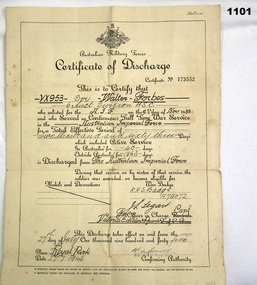
Walter William Forbes enlisted on 6.11.39 serving 40 days in Australia and 1863 days overseas. He was taken P.O.W in North Africa and imprisoned in Germany. Discharged from the A.I.F 27.7.45. Refer 1102, 1103.44, 1106."Certificate of Discharge" from the 2nd A.I.F re W. Forbes. On yellow parchment paper, double sided giving details of his Name, Rank, Regt No, period of Service, dates and physical appearance."Certificate No 173552" "VX 953 Dvr Walter Forbes 6 Aust Division ASC"documents - certificates, military history, army/records, forbes, pow -
 Bendigo Military Museum
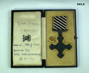
Award - MEDAL DFC, C.1944 - 46
Allan Frederick GOODALL DFC. Allan enlisted in the RAAF on 10.10.1941 No 409828 age 18 years. He was mustered as Aircrew on elisted and was designated as WO/AG ( Wireless operator Air Gunner) on 23.7.1942. he rose through the ranks from AC2, LAC, Sgt, F/Sgt, W/O, F/O to Flt/Lt on 1.3.1945. Embarked for England on 24.8.1942 and posted to RAF Station Bournemouth on 18 .11.1942, posted to MEC (Middle East Command) with 150 Sqd RAF flying Wellingtons from North Africa. On 21.12.1943 on a non operational flight from Africa to Italy his flight crashed into Mt Etna, they were coming out of a cloud when the Pilot saw Etna. Allan as least injured made sure his mates were okay and sheltered he walked down to a nearby village (Maletto) to get help. Allan spent from 21.12.1943 to 5.1.1944 in hospital with Abrasions. He was awarded the DFC (Distinguished Flying Cross) in 1944 for operations over Italy, at the time he was classed as Sqd Signals Leader. According to his records he flew 37 Operational sorties. He was discharged from the RAAF on 3.1.1946. The crew of the Plane were; Bruce Hayman (NZ) Pilot, Fractured leg. Allan Goodall Aust (WOP/AG) abrasions and injured wrist. Alan Warner (Aust) Navigator, Fractured Ankle. Y.F.Redknap (UK) injured shoulder. C.A. Carr (UK) Fractured Dorsal Spine. J.E. Ward (UK) Dislocated shoulder. Alfred Dugdale (UK) Deceased. Tony Moore (UK) Deceased. Both are buried at the Catania War Cemetery Sicily. Refer Cat No 1025P for his photo.543.1 Medal-Distinguished FLying Cross won by FO Alan F Goodall. Rear of medal is engraved "Italy FO Alan Goodall 1944" 543.2 Case-to suit DFC above. Case rear has a note "Alan's sister Jean, Mrs R.T Mitchell, 22 O'Dea Cres Kangaroo Flat 3555 471428." Written inside case in pen "F/O Alan Goodall Bendigo Won in Italy 1944 Presented by HRH Duke of Gloucester 13-11-1946"awards, dfc ww2, raaf -
 Bendigo Military Museum
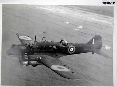
Photograph - PHOTOGRAPHS, RAAF, c.1939-45
... of Airmen marching past Hawker demons .3) 3P North American b&w...) 3P North American b&w RAAF P51 Mustang Number A68-585 .4) 4P ...Items belonged to Maxwell Lennox Matheson No 418447 RAAF. Refer Cat No 1959 for his service records.Envelope containing 5 photos: .1) 1P Auro Anson T.1 - Fuselage number W2083 .2) 2P Laverton RAAF Base B&W c.1938 Bunch of Airmen marching past Hawker demons .3) 3P North American b&w RAAF P51 Mustang Number A68-585 .4) 4P Airspeed 'Oxford' b&w Fuselage Number V3354 .5) 5P Blue print 'Wirraway' Fighter/Bomber.1) 3 Lines description on rear. RAF Aircraft issued to RAF .2) Laverton RAAF Base C1938 & 2 lines about Hawker Demons & Auro Ansons .3) 5 lines about history of P51 & No 84 Sqn 1945 .4) Rear inscription 4 historical lines about AIirspeed Oxfords .5) Front inscription on blue print: Wirraway' as a General Purpose Trainer Aircraft No A70-98 Wirraway' as a Dive Bomber Aircraft No A20-754photography -photographs, raaf -
 Bendigo Military Museum
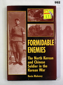
Book, Formidable Enemies, 2001
Black hard cover with black and brown dust jacket. Dust jacket has six sepia photos of North Korean and Chinese soldiers during the Korean war. Illustrated section in centre of book (black and white). Author - Kevin MAHONEY. 174 pages.Written on first page - "Francis W. DEAN. BEM"books, military history -
Federation University Historical Collection
Letter, Ballarat School of Mines Rough Correspondence, 1916-1917, 1916-17
The Ballarat School of Mines was established in 1870, and is a predecessor institution of Federation University Australia. A bundle of rough correspondence from the Ballarat School of Mines. Includes Ballarat School of Mines Letterhead, a list of Trade Students, their address and the fees they paid; Special Grant for Photography Equipment; Building valuations; Annual Staff Social, Ballarat School of Mines Technical School Annual Report, Quarterly Attendance Return, Medical Certificate ballarat school of mines, 45th a.a.m.c., 49th a.a.m.c., camp, f.c. buchanan, e.l. fidge, r.c. valentine, r.c. smith, j.m. turnbull, w.l. carroll, e.w. simmering, f.m. wesley, k. whittle, allan bernaldo, j.b. sutcliffe, e.n.t. henry, f.t. jellett, a.p. doran, e. somerville, t.h. robinson, ballarat school of mines evening trade time table, victorian education department receipt, letterhead, charles graham, h.s. hall, gauge tower, trade fees., trades, f.r. eva, m.a. fiscalini, v. giuliano, walter baxter, humffray, james walker, clemence hill, mcpherson's pty ltd, robinson, telephone account, charles e. bright, plumbing, g.r. king, a.e. anderson, buildings, n.r. worrell, h.v. duncan, ballarat junior technical school, a.w. steane, philately, stamp duty, bhp, broken hill, excursion, broken hill south mining co, g. fenner, wallaroo, moonta, daniel walker, t.h. shattock, j.m. sutherland, myra bolte, nellie grigg, j.a. greenshields, dora gooch, myra howe, mavis mcgrath, charles mcnamara, kath reidy, percy albert trompf, percy trompf, h.g. wakeling, rene hardess, quarterly returns, accounting, sands and mcdougall, travel lists, w. coltman, gladys kitchen, h. beanland, eva betteridge, victor greenhalgh, staff salary, goliath and hercules, cuming smith and co, australian engineering school, e.j. powell, e.w. hurfield, e.j. mcconnon, hilda wardle, dorothy hambly, assay report, north woah hawp, supplementary examinations, hugh m. rowlands, frank b. maxwell, richard buchanan, walter j. ewart, r.f. finnis, f.g. davis, w.g. walker, charles schroeder, k. bailey fisher, robert hutchinson, w. o'halloran, s.j. chambers, a. westcott, m.f. larking, k. jebb, john dulfer, daniel liddy, louis vernon, pharmacy board victoria, scholarships, david cochrane, howard bennett, herbert werner frederick de nully, thomas robinson, john sutcliffe, thomas carmichael, bessie beatrice robertson -
 Frankston RSL Sub Branch
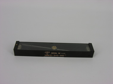
Compass, Plane Table, J. W. Handley, 1943
A plane table compass, sometimes referred to as a trough compass, used by surveyors and artillery crew to accurately establish magnetic north. The compass is precision machined of brass material with a long needle to ensure accuracy. The compass scale is marked with a centre zero (for magnetic north) and graduations indicating plus and minus five degrees. The compass is housed in a protective wooden case with a sliding lid. The lid has a brass slide which locks the compass needle during periods when the compass is not in use. This compass is the type used by an artillery unit of the Australian Military Forces during World War 2. This compass was manufactured by J. W. Handley P/L of Melbourne in 1943. Refer 00330 and 00330.2The side of the compass body is stamped: "J.W.H." with the letter "V" under a line, "SERIAL No 1082", MARK.II-D^D-1943". The case is stamped with the serial number "1082".artillery, trough compass, plane table compass, compass, world war 2, ww2 -
Frankston RSL Sub Branch
Compass, Astro
A World War 2 era W. W. Boes and Co. MKll astro compass typically used as an aviation navigation aid. It is manufactured from aluminum with black enamel finish. An astro compass is a navigational tool used to determine true north from the position of the sun or astronomical bodies. These are used in circumstances where magnetic compasses and gyrocompasses are unreliable, for example in the presence of magnetic field anomalies (such as polar regions, ships hulls, aircraft hulls, etc.). Nameplate on the base reads "ASTRO-COMPASS MK II / The W.W. BOES CO. / DAYTON, OHIO, USA"compass, astro compass, navigation, aeronautical, raaf, raf, ww2,