Showing 537 items matching "100 years history"
-
 Tatura Irrigation & Wartime Camps Museum
Book, 100 Years of Gleanings, 1994
... Written to record history of journalism for 100 years... Tatura the-murray Written to record history of journalism for 100 ...Written to record history of journalism for 100 years of Kyabram Free Press and Kyabram historyHistorical presentation of Kyabram and District Allan Street, photographs 1905, 1962. Plain back cover while front shows newspaper printkyabram free press, kyabram history, kyabram journalism -
Tatura Irrigation & Wartime Camps Museum
Book, From Chock & Log to Rolltop, 1985
... Written to preserve the history of 100 years of Toolamba... Tatura the-murray Written to preserve the history of 100 years ...Written to preserve the history of 100 years of Toolamba South State School No. 2728, now Toolamba West Primary School, 1885-1985. A chock and log fence was first. Present fence is rolltopMottled beige cover, brown writing. Toolamba West School song on back, composed in 1976. On the front cover is an abstract drawing designed by Trevor Williams depiciting the three schoolsbooks, school, education -
Tatura Irrigation & Wartime Camps Museum
Booklet, Tatura Milk A Century of Dairying 1907-2007, 2007
To commemorate 100 years for Tatura Milk Industries. In 1907 the Tatura Butter Factory was formed. Includes history and photos of early Chairmen and Managers. Bega Cheeses is now a part ownerBrown cover, gold writing on front cover, early photo of factory and trucks and modern machinery. Dairy cattle on the back coverdairying, documents, history, local, rural, industry -
Tatura Irrigation & Wartime Camps Museum
Booklet, Tatura Milk A Century of Dairying 1907-2007, 2007
To commemorate 100 years of Tatura Milk Industries. In 1907 the Tatura Butter Factory was formed. Includes history and photographs of early Chairmen and Managers. Bega Cheese is now part owner.Brown cover, gold writing on front cover early photograph of factory and trucks and modern machinery. Dairy cattle on back coverdairy industry, bega cheese, tatura milk, tatura industries, tatura butter factory -
 University of Melbourne, Burnley Campus Archives
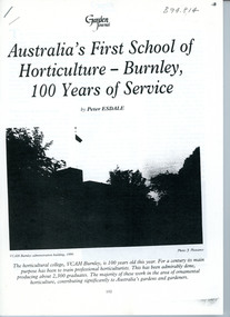
Article, Peter Esdale, Australia's First School of Horticulture - Burnley, 100 years of Service, c. 1991
A five paged article photocopied from "The Australian Garden Journal" by Peter Esdale. Journal dated Feb/March 1991, Vol 10 No 3. The article gives a brief history of the Horticultural College and informing readers about the courses offered in 1991. Illustrations.5-page article by Peter Esdale from Garden Journal, Vol. 10, No. 3, Feb. - March 1991peter esdale, garden journal, the australian garden journal, burnley gardens centenary -
 University of Melbourne, Burnley Campus Archives
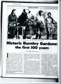
Article, D.H. Aldous, Historic Burnley Gardens: the first 100 years, 1989
"Historic Burnley Gardens: the first 100 years"; a four page article from the March 1989 issue of "Australian Horticulture" written by D.E. Aldous and TH Kneen; it gives a summary of the history of Burnley College. Several illustrations are included. 4-page article by D.H. Aldous & T.H.Kneen from Australian Horticulture, March 1989d.h. aldous, thomas.h. kneen, australian horticulture, burnley gardens centenary -
University of Melbourne, Burnley Campus Archives
Document, Peter Esdale, The Burnley Legacy; 100 years of Landscape Education at Burnley Gardens, 1991
Draft(?) of article for Centenary History of Horticultural Education at Burnley Gardens, by Peter Esdalecentenary, peter esdale -
 Melbourne Athenaeum Archives
Video - ABC 7.30 Report: The Athenaeum 's 170th birthday, Australian Broadcasting Corporation, Melbourne, Athenaeum building celebrates 170 years, 11/11/2009
Transcript: Athenaeum building celebrates 170 years Australian Broadcasting Corporation Broadcast: 11/11/2009 Reporter: Lisa Whitehead Tomorrow marks the 170th birthday of one of the nation's historic cultural landmarks. Melbourne’s Athenaeum building has, in one form or other, provided education and entertainment for the Victorian colony as it became a city; and along the way, documented its growth. Transcript KERRY O’BRIEN, PRESENTER: Tomorrow marks the 170th birthday of one of the nation's historic cultural landmarks. Melbourne's Athenaeum building has, in one form or another, provided education and entertainment. For the Victorian colonies it became a city and along the way documented its growth. The building's original library and theatre still draw devotees and as Lisa Whitehead reports, a loyal band of volunteers. KEVIN QUIGLEY, ATHENAEUM PRESIDENT: There's nothing like us that has been here from day one, four years after the boat pushed ashore, here we are. It's a thread that runs through the life of Melbourne. LISA WHITEHEAD, REPORTER: In the heart of Melbourne's CBD, the Athenaeum is a celebrity in disguise, the oldest cultural icon in the city, but barely noticed. MARJORIE DALVEAN, VOLUNTEER HISTORIAN: People of Melbourne walk past this area and they have no idea what it is. RAY LAWLER, PLAYWRIGHT: It seemed to me to be a place that absolutely, or breathes Melbourne, I suppose, culture. LISA WHITEHEAD: Just four years after Melbourne was founded, the colony built a Mechanic's Institution, one of the first in the world, a place where the working class could meet and learn. KEVIN QUIGLEY: People think of it as Wild West sort of place where these hearty types drank and rushed about, but Melbourne was freely settled. It was a city of people who wanted to better themselves - entrepreneurs. And the Mechanic's Institution was that innovative idea that had grown up in Edinburgh and London about providing an opportunity for education for the working people. LISA WHITEHEAD: Mark Twain lectured there. Later, other buildings were added and a theatre to host classic plays. And it adopted its more bourgeois friendly title of the Athenaeum. Crucially from the start there was the library, the first to offer affordable lending to the working man. And it still attracts devotees. Former University lecturer Margaret Bowman, 89, comes in every Wednesday, along with her dog to join an enthusiastic band of volunteers sorting through the archives. MARGARET BOWMAN, FORMER UNIVERSITY LECTURER: Doing research is something that I find actually I enjoy more than anything. Every old lady needs to have a project and now I've got a project. MARJORIE DALVEAN: Margaret, Christine has just found out that Alfred Deakin was a member here from 1874 to 1877. This place is not flashy, we've never been flashy. But book lovers walk in here and they know this is the place for them. ARCHIVAL FOOTAGE: Old times and old names. The Athenaeum theatre in Melbourne for more than 40 years has been one of the city's best known cinemas. LISA WHITEHEAD: In the 20th century, the theatre surrendered to the new craze of talking pictures, and one particular fan was famous Australian playwright Ray Lawler. At 13, he dropped out of school to work in a Footscray factory and two years later his first trip to the glamorous Athenaeum cinema hinted at the education he was missing. RAY LAWLER: It just had a style about it which I responded to, I think. I was looking for something and this seemed to be part of it. Ray Lawler went on to write "Summer of the Seventeenth Doll" and found literary fame overseas. About a century after it had started as an educational place for the working man, Ray Lawler had, in effect, become an Athenaeum graduate. RAL LAWLER: If they had been looking for the sort of person that they were hoping to encourage along the way, I suppose I would have been somebody that might have fitted the mould, you know. LISA WHITEHEAD: In time, the cinema was returned to its theatrical roots. FRANK THRING, 1977: It has a great resemblance to the Theatre Royal in Hobart which Larry Olivier has called the best theatre he's ever worked in. And it's almost identical. It is the true Victorian playhouse. The horseshoe shaped thing: stalls, dress circle and gallery. And you're close to the audience and they're close to you. Marvellous feeling. LISA WHITEHEAD: Today, it's still a theatre. But time has brought compromises. The once vaunted art gallery has now covered its windows and become a comedy club and performance space. TV and suburban life have eaten away at the library membership. It offers an online service now, and a recent federal government grant will pay for the upkeep of its gracious interior, including the 1930s elevator Ray Lawler used to ride. For him, it's money well spent on history quietly made and discreetly observed. RAY LAWLER: It's the lack of awareness, I think, that people don't know what they've got here. They've really got the whole history of Melbourne almost. KEVIN QUIGLEY: It was a similar organisation in Sydney but we are the only one that's got a continual lineage on the same spot. We started here and we're still here and we'll be here for another 100 years. KERRY O'BRIEN: Lisa Whitehead on a great Melbourne landmark. © 2010 ABC | Privacy Policy Beginning as the Melbourne Mechanics' Institution in 1839, the Melbourne Athenaeum has a long history that reflects the cultural and social development of Melbourne. It continues to be managed as a not-for-profit organisation by a volunteer board, with a subscription library (maintained since 1839) and a leased theatre.Video broadcast ABC 7:30 Report for 11/11/2009. "Tomorrow marks the 170th birthday of one of the nation's historic cultural landmarks. Melbourne’s Athenaeum building has, in one form or other, provided education and entertainment for the Victorian colony as it became a city; and along the way, documented its growth."athenaeum, australian broadcasting corporation, kerry o’brien, kevin quigley, lisa whitehead, marjorie dalvean, ray lawler, margaret bowman, frank thring. -
Clunes Museum
Tool - TOBACCO CUTTER
THIS TOBACCO CUTTER REMAINED ON THE BAR OF THE SWISS MOUNTAIN INN, BLAMPIED; FOR MORE THAN 100 YEARS. THE HOTEL WAS OWNED BY THE LACRANCHI FAMILYCAST IRON KNIFE WITH A WOODEN HANDLE IS ATTACHED TO A WOODEN BLOCK FOR THE TOBACCOlocal history, metalcraft, cast iron on wood, smoking accessories -
 Peterborough History Group
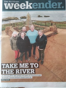
Article, Warrnambool Standard, Centenary of the drowning of Jame Irvine while crossing the river, 2019
The article is about the drowning 100 years previously of James Irvine, proprietor of Peterborough House and later the Peterborough Hotel.James Irvine was so well regarded that a community collection raised funds to build the Memorial, which still stands today. Five surviving great grand children retain connection to the town.Three page article with current and historic photosjames irvine, james irvine memorial reserve, peterborough, peterborough house, peterborough hotel, drowning -
National Wool Museum
Sale notice, "Darriwill"
Sale notice lists property as belonging to the Hope family for the last 100 years, who were the original owners. The property contains a bluestone house, stables, a carpenters shop, two cottages, working ammenities, all fronting the Moorabool River and Sutherland Creek. Notice was used in the NWM Woolbrokers office display.sheep stations - history property sales wool brokering, dennys, lascelles limited strachan and co. limited, hope, mr alistair, sheep stations - history, property sales, wool brokering -
Koorie Heritage Trust
Book, Boyes, Rosemary (Peg), 100 years at S.S. 2222 Baranduda 1880-1980 : a centenary history, also some history of the district and families, 1980
This souvenir publication is a centenary celebration of BARANUDA STATE SCHOOL NO. 2222, 1880-1980. Includes bibliographical references.pp.100; illus.;figs.;21 cm.This souvenir publication is a centenary celebration of BARANUDA STATE SCHOOL NO. 2222, 1880-1980. Includes bibliographical references.baranduda state school -- history. | schools -- victoria -- history. | baranduda region (vic.) -- history. | -
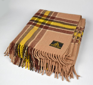 National Wool Museum
Textile - Travel Rug, Albany Woollen Mills, c1960s
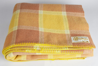
Collector says - "I can still recall one of my earliest childhood memories, of my nana's bright aqua shoes against the checks of our family travel rug on summer picnics. Maybe that's when this collection planted its seed in me - 40 years later I start my first blanket collection after stumbling across old Onkaparinga travel rugs. I would go to a vintage market in Collingwood every month and almost always found a good one, amassing enough for the entire household. Everyone had their favourite, even the cat had his own – a small red tartan one just for him." Note from collector-"For more than 100 years blankets were made all over Australia in over 100 woollen mills. My aim, is to preserve 100 examples of these wonderful pieces of history. Ten years ago I started collecting the iconic Onkaparinga travel rugs, so that on movie nights at home there would be plenty to go around. Everyone had their favourite; even the cat had his own – a small red tartan one. Keeping an eye out for those travel rugs at op-shops and markets, collectable stores and bazaars, led to noticing vintage blankets. I'd never really thought about them before or paid much attention though of course I had grown up with them at my grandmother's. When I discovered my first Laconia cream blanket with blue stripes, my eyes just went gaga. Well that was it, I was hooked and since then over 500 blankets have passed through my hands. These common, everyday items, found in all households for so many decades, were traditional engagement gifts. Pairs were prized wedding presents turning into family heirlooms. They were fashionable dressers of beds, givers of warmth, bestowers of security and reliability. The comfort found in these objects resonates with almost all of us; we grew up with them ourselves or fondly recall them in a grandparent’s home. There is no modern replacement with the integrity of these old blankets, many of them now older than most of us. They are romantic, sensible, special, familiar, nostalgic and nothing else feels so appropriate in so many situations. No offense to the great Aussie doona, but from hippie to hipster, at a music festival, picnic, campsite or couch, a vintage blanket is something coveted by all. This industry that employed tens of thousands and must have been such a huge contributor to the economy is almost completely lost now. Blanket Fever is an ode to everything that came before: the land, the sheep, the shearers, the hands, the mills, the weavers, the designers, the distributors, the department stores. To the grandparents that gave them, the people that received them, the families that kept them; thank you. I’m passionate about my collection of Australian blankets manufactured in mostly Victoria, South Australia and Tasmania from the 1930s to the end of the 1960s. The collection has blankets from each of these four decades representing the styles and fashions of their time and includes dated advertisements which help determine the eras the blankets are from. " Tan and brown plaid fringed travel rug. Albany Woollen Mill/Travel Rug/All Pure Wool/Emblem: A, Albany blanket, blanket fever, wool, rug, albany, albany woollen mills -
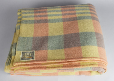
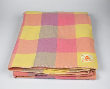 National Wool Museum
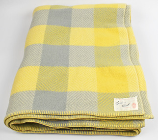
Textile - Blanket, Albany Woollen Mills, Albany Woollen Mills blanket, c 1950s
Note from collector: I love the generous size and thickness of Albany blankets and know someone who collects from this Mill only. The colour shades and combinations Albany used are still so gorgeous. From Western Australia. Note from collector - "For more than 100 years blankets were made all over Australia in over 100 woollen mills. My aim, is to preserve 100 examples of these wonderful pieces of history. Ten years ago I started collecting the iconic Onkaparinga travel rugs, so that on movie nights at home there would be plenty to go around. Everyone had their favourite; even the cat had his own – a small red tartan one. Keeping an eye out for those travel rugs at op-shops and markets, collectable stores and bazaars, led to noticing vintage blankets. I'd never really thought about them before or paid much attention though of course I had grown up with them at my grandmother's. When I discovered my first Laconia cream blanket with blue stripes, my eyes just went gaga. Well that was it, I was hooked and since then over 500 blankets have passed through my hands. These common, everyday items, found in all households for so many decades, were traditional engagement gifts. Pairs were prized wedding presents turning into family heirlooms. They were fashionable dressers of beds, givers of warmth, bestowers of security and reliability. The comfort found in these objects resonates with almost all of us; we grew up with them ourselves or fondly recall them in a grandparent’s home. There is no modern replacement with the integrity of these old blankets, many of them now older than most of us. They are romantic, sensible, special, familiar, nostalgic and nothing else feels so appropriate in so many situations. No offense to the great Aussie doona, but from hippie to hipster, at a music festival, picnic, campsite or couch, a vintage blanket is something coveted by all. This industry that employed tens of thousands and must have been such a huge contributor to the economy is almost completely lost now. Blanket Fever is an ode to everything that came before: the land, the sheep, the shearers, the hands, the mills, the weavers, the designers, the distributors, the department stores. To the grandparents that gave them, the people that received them, the families that kept them; thank you. I’m passionate about my collection of Australian blankets manufactured in mostly Victoria, South Australia and Tasmania from the 1930s to the end of the 1960s. The collection has blankets from each of these four decades representing the styles and fashions of their time and includes dated advertisements which help determine the eras the blankets are from. " Checked blanket, pink, lemon and violetAlbany Woollen Mill/Blanket/All Pure Wool/Emblem: A, Albany blanket, blanket fever, wool, albany, albany woollen mills -
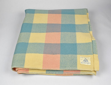 National Wool Museum
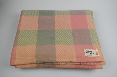
Textile - Blanket, Albany Woollen Mills, c1950s
Collector says "I love the generous size and thickness of Albany blankets and know someone who collects from this Mill only. The colour shades and combinations Albany used are still so gorgeous. From Western Australia. Note from Collector - "For more than 100 years blankets were made all over Australia in over 100 woollen mills. My aim, is to preserve 100 examples of these wonderful pieces of history. Ten years ago I started collecting the iconic Onkaparinga travel rugs, so that on movie nights at home there would be plenty to go around. Everyone had their favourite; even the cat had his own – a small red tartan one. Keeping an eye out for those travel rugs at op-shops and markets, collectable stores and bazaars, led to noticing vintage blankets. I'd never really thought about them before or paid much attention though of course I had grown up with them at my grandmother's. When I discovered my first Laconia cream blanket with blue stripes, my eyes just went gaga. Well that was it, I was hooked and since then over 500 blankets have passed through my hands. These common, everyday items, found in all households for so many decades, were traditional engagement gifts. Pairs were prized wedding presents turning into family heirlooms. They were fashionable dressers of beds, givers of warmth, bestowers of security and reliability. The comfort found in these objects resonates with almost all of us; we grew up with them ourselves or fondly recall them in a grandparent’s home. There is no modern replacement with the integrity of these old blankets, many of them now older than most of us. They are romantic, sensible, special, familiar, nostalgic and nothing else feels so appropriate in so many situations. No offense to the great Aussie doona, but from hippie to hipster, at a music festival, picnic, campsite or couch, a vintage blanket is something coveted by all. This industry that employed tens of thousands and must have been such a huge contributor to the economy is almost completely lost now. Blanket Fever is an ode to everything that came before: the land, the sheep, the shearers, the hands, the mills, the weavers, the designers, the distributors, the department stores. To the grandparents that gave them, the people that received them, the families that kept them; thank you. I’m passionate about my collection of Australian blankets manufactured in mostly Victoria, South Australia and Tasmania from the 1930s to the end of the 1960s. The collection has blankets from each of these four decades representing the styles and fashions of their time and includes dated advertisements which help determine the eras the blankets are from. Please refer to the following worksheet for a full breakdown of the collection." Checked blanket, pink, blue and creamAlbany Woollen Mill/Blanket/All Pure Wool/Emblem: A, Albany blanket, blanket fever, wool, albany, albany woollen mills -
 National Wool Museum
Textile - Blanket, Castlemaine Woollen Mill, c1950s
Collector says - "Once I had gathered a dozen or so blankets, I started noticing the many different labels; where they were made, by who, the logos and fonts used. Then the labels became a thing, then the blankets had to have a label to join the collection. My favourite labels are by Physician, they had at least 4 different labels over the decades but the best has to be the Lady In Bed logo. Physician, Onkaparinga, Eagley and others matched the colour of the label to the colour of the blanket - a nice touch. Strangely, Castlemaine labels were always sewn on the back of the blanket where all the other mills sewed theirs on the front. To this day I always roll or fold a blanket with its label on display." Note from Collector - "For more than 100 years blankets were made all over Australia in over 100 woollen mills. My aim, is to preserve 100 examples of these wonderful pieces of history. Ten years ago I started collecting the iconic Onkaparinga travel rugs, so that on movie nights at home there would be plenty to go around. Everyone had their favourite; even the cat had his own – a small red tartan one. Keeping an eye out for those travel rugs at op-shops and markets, collectable stores and bazaars, led to noticing vintage blankets. I'd never really thought about them before or paid much attention though of course I had grown up with them at my grandmother's. When I discovered my first Laconia cream blanket with blue stripes, my eyes just went gaga. Well that was it, I was hooked and since then over 500 blankets have passed through my hands. These common, everyday items, found in all households for so many decades, were traditional engagement gifts. Pairs were prized wedding presents turning into family heirlooms. They were fashionable dressers of beds, givers of warmth, bestowers of security and reliability. The comfort found in these objects resonates with almost all of us; we grew up with them ourselves or fondly recall them in a grandparent’s home. There is no modern replacement with the integrity of these old blankets, many of them now older than most of us. They are romantic, sensible, special, familiar, nostalgic and nothing else feels so appropriate in so many situations. No offense to the great Aussie doona, but from hippie to hipster, at a music festival, picnic, campsite or couch, a vintage blanket is something coveted by all. This industry that employed tens of thousands and must have been such a huge contributor to the economy is almost completely lost now. Blanket Fever is an ode to everything that came before: the land, the sheep, the shearers, the hands, the mills, the weavers, the designers, the distributors, the department stores. To the grandparents that gave them, the people that received them, the families that kept them; thank you. I’m passionate about my collection of Australian blankets manufactured in mostly Victoria, South Australia and Tasmania from the 1930s to the end of the 1960s. The collection has blankets from each of these four decades representing the styles and fashions of their time and includes dated advertisements which help determine the eras the blankets are from." Checked blanket, pink, blue and creamCastlemaine/100 pure virgin wool blanket, blanket fever, wool, castlemaine, castlemaine woollen mill -
 National Wool Museum
Textile - Blanket, Challenge Woollen Mills, Clan Murray series of Challenge, c1950s
Collector says - "Once I had gathered a dozen or so blankets, I started noticing the many different labels; where they were made, by who, the logos and fonts used. Then the labels became a thing, then the blankets had to have a label to join the collection. My favourite labels are by Physician, they had at least 4 different labels over the decades but the best has to be the Lady In Bed logo. Physician, Onkaparinga, Eagley and others matched the colour of the label to the colour of the blanket - a nice touch. Strangely, Castlemaine labels were always sewn on the back of the blanket where all the other mills sewed theirs on the front. To this day I always roll or fold a blanket with its label on display." " For more than 100 years blankets were made all over Australia in over 100 woollen mills. My aim, is to preserve 100 examples of these wonderful pieces of history. Ten years ago I started collecting the iconic Onkaparinga travel rugs, so that on movie nights at home there would be plenty to go around. Everyone had their favourite; even the cat had his own – a small red tartan one. Keeping an eye out for those travel rugs at op-shops and markets, collectable stores and bazaars, led to noticing vintage blankets. I'd never really thought about them before or paid much attention though of course I had grown up with them at my grandmother's. When I discovered my first Laconia cream blanket with blue stripes, my eyes just went gaga. Well that was it, I was hooked and since then over 500 blankets have passed through my hands. These common, everyday items, found in all households for so many decades, were traditional engagement gifts. Pairs were prized wedding presents turning into family heirlooms. They were fashionable dressers of beds, givers of warmth, bestowers of security and reliability. The comfort found in these objects resonates with almost all of us; we grew up with them ourselves or fondly recall them in a grandparent’s home. There is no modern replacement with the integrity of these old blankets, many of them now older than most of us. They are romantic, sensible, special, familiar, nostalgic and nothing else feels so appropriate in so many situations. No offense to the great Aussie doona, but from hippie to hipster, at a music festival, picnic, campsite or couch, a vintage blanket is something coveted by all. This industry that employed tens of thousands and must have been such a huge contributor to the economy is almost completely lost now. Blanket Fever is an ode to everything that came before: the land, the sheep, the shearers, the hands, the mills, the weavers, the designers, the distributors, the department stores. To the grandparents that gave them, the people that received them, the families that kept them; thank you. I’m passionate about my collection of Australian blankets manufactured in mostly Victoria, South Australia and Tasmania from the 1930s to the end of the 1960s. The collection has blankets from each of these four decades representing the styles and fashions of their time and includes dated advertisements which help determine the eras the blankets are from." Checked blanket, pink, blue and lavenderClan Murray series of Challenge/Lambswool 'Perma-nap' blankets/All pure wool/Super Grade blanket, blanket fever, wool, challenge woollen mills -
 National Wool Museum
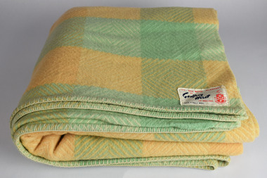
Textile - Blanket, Eagley Woollen Mills, 1960s
Note from collector: Once I had gathered a dozen or so blankets, I started noticing the many different labels; where they were made, by who, the logos and fonts used. Then the labels became a thing, then the blankets had to have a label to join the collection. My favourite labels are by Physician, they had at least 4 different labels over the decades but the best has to be the Lady In Bed logo. Physician, Onkaparinga, Eagley and others matched the colour of the label to the colour of the blanket - a nice touch. Strangely, Castlemaine labels were always sewn on the back of the blanket where all the other mills sewed theirs on the front. To this day I always roll or fold a blanket with its label on display.Note from collector- "For more than 100 years blankets were made all over Australia in over 100 woollen mills. My aim, is to preserve 100 examples of these wonderful pieces of history. Ten years ago I started collecting the iconic Onkaparinga travel rugs, so that on movie nights at home there would be plenty to go around. Everyone had their favourite; even the cat had his own – a small red tartan one. Keeping an eye out for those travel rugs at op-shops and markets, collectable stores and bazaars, led to noticing vintage blankets. I'd never really thought about them before or paid much attention though of course I had grown up with them at my grandmother's. When I discovered my first Laconia cream blanket with blue stripes, my eyes just went gaga. Well that was it, I was hooked and since then over 500 blankets have passed through my hands. These common, everyday items, found in all households for so many decades, were traditional engagement gifts. Pairs were prized wedding presents turning into family heirlooms. They were fashionable dressers of beds, givers of warmth, bestowers of security and reliability. The comfort found in these objects resonates with almost all of us; we grew up with them ourselves or fondly recall them in a grandparent’s home. There is no modern replacement with the integrity of these old blankets, many of them now older than most of us. They are romantic, sensible, special, familiar, nostalgic and nothing else feels so appropriate in so many situations. No offense to the great Aussie doona, but from hippie to hipster, at a music festival, picnic, campsite or couch, a vintage blanket is something coveted by all. This industry that employed tens of thousands and must have been such a huge contributor to the economy is almost completely lost now. Blanket Fever is an ode to everything that came before: the land, the sheep, the shearers, the hands, the mills, the weavers, the designers, the distributors, the department stores. To the grandparents that gave them, the people that received them, the families that kept them; thank you. I’m passionate about my collection of Australian blankets manufactured in mostly Victoria, South Australia and Tasmania from the 1930s to the end of the 1960s. The collection has blankets from each of these four decades representing the styles and fashions of their time and includes dated advertisements which help determine the eras the blankets are from. " Queen sized brown, green and blue checked blanketEagley Blanket, Pure Woolblanket, blanket fever, wool, eagley woollen mills, victoria -
 National Wool Museum
Textile - Blanket, Waverley Woollen Mills, 1960s
Note from collector: I adore these bright blankets with their labels depicting summer times. For most blanketeers, the Laconia Mexicana is a bit of a holy grail - for the label just as much as the blanket. Laconia made the Mexicana in 1964 and I suspect the Waverley and Onkaparinga came afterwards.Note from collector- "For more than 100 years blankets were made all over Australia in over 100 woollen mills. My aim, is to preserve 100 examples of these wonderful pieces of history. Ten years ago I started collecting the iconic Onkaparinga travel rugs, so that on movie nights at home there would be plenty to go around. Everyone had their favourite; even the cat had his own – a small red tartan one. Keeping an eye out for those travel rugs at op-shops and markets, collectable stores and bazaars, led to noticing vintage blankets. I'd never really thought about them before or paid much attention though of course I had grown up with them at my grandmother's. When I discovered my first Laconia cream blanket with blue stripes, my eyes just went gaga. Well that was it, I was hooked and since then over 500 blankets have passed through my hands. These common, everyday items, found in all households for so many decades, were traditional engagement gifts. Pairs were prized wedding presents turning into family heirlooms. They were fashionable dressers of beds, givers of warmth, bestowers of security and reliability. The comfort found in these objects resonates with almost all of us; we grew up with them ourselves or fondly recall them in a grandparent’s home. There is no modern replacement with the integrity of these old blankets, many of them now older than most of us. They are romantic, sensible, special, familiar, nostalgic and nothing else feels so appropriate in so many situations. No offense to the great Aussie doona, but from hippie to hipster, at a music festival, picnic, campsite or couch, a vintage blanket is something coveted by all. This industry that employed tens of thousands and must have been such a huge contributor to the economy is almost completely lost now. Blanket Fever is an ode to everything that came before: the land, the sheep, the shearers, the hands, the mills, the weavers, the designers, the distributors, the department stores. To the grandparents that gave them, the people that received them, the families that kept them; thank you. I’m passionate about my collection of Australian blankets manufactured in mostly Victoria, South Australia and Tasmania from the 1930s to the end of the 1960s. The collection has blankets from each of these four decades representing the styles and fashions of their time and includes dated advertisements which help determine the eras the blankets are from." Waverley 'El Rio' Multicoloured checked Double sized blanketEl Rio Blanket/By Waverley/Pure Woolblankets, blanket fever, wool, el rio, waverley, launceston -
 National Wool Museum
Textile - Blanket, Invicta Mills, 1950s
Note from collector: Once I had gathered a dozen or so blankets, I started noticing the many different labels; where they were made, by who, the logos and fonts used. Then the labels became a thing, then the blankets had to have a label to join the collection. My favourite labels are by Physician, they had at least 4 different labels over the decades but the best has to be the Lady In Bed logo. Physician, Onkaparinga, Eagley and others matched the colour of the label to the colour of the blanket - a nice touch. Strangely, Castlemaine labels were always sewn on the back of the blanket where all the other mills sewed theirs on the front. To this day I always roll or fold a blanket with its label on display.Note from collector- "For more than 100 years blankets were made all over Australia in over 100 woollen mills. My aim, is to preserve 100 examples of these wonderful pieces of history. Ten years ago I started collecting the iconic Onkaparinga travel rugs, so that on movie nights at home there would be plenty to go around. Everyone had their favourite; even the cat had his own – a small red tartan one. Keeping an eye out for those travel rugs at op-shops and markets, collectable stores and bazaars, led to noticing vintage blankets. I'd never really thought about them before or paid much attention though of course I had grown up with them at my grandmother's. When I discovered my first Laconia cream blanket with blue stripes, my eyes just went gaga. Well that was it, I was hooked and since then over 500 blankets have passed through my hands. These common, everyday items, found in all households for so many decades, were traditional engagement gifts. Pairs were prized wedding presents turning into family heirlooms. They were fashionable dressers of beds, givers of warmth, bestowers of security and reliability. The comfort found in these objects resonates with almost all of us; we grew up with them ourselves or fondly recall them in a grandparent’s home. There is no modern replacement with the integrity of these old blankets, many of them now older than most of us. They are romantic, sensible, special, familiar, nostalgic and nothing else feels so appropriate in so many situations. No offense to the great Aussie doona, but from hippie to hipster, at a music festival, picnic, campsite or couch, a vintage blanket is something coveted by all. This industry that employed tens of thousands and must have been such a huge contributor to the economy is almost completely lost now. Blanket Fever is an ode to everything that came before: the land, the sheep, the shearers, the hands, the mills, the weavers, the designers, the distributors, the department stores. To the grandparents that gave them, the people that received them, the families that kept them; thank you. I’m passionate about my collection of Australian blankets manufactured in mostly Victoria, South Australia and Tasmania from the 1930s to the end of the 1960s. The collection has blankets from each of these four decades representing the styles and fashions of their time and includes dated advertisements which help determine the eras the blankets are from." Double sized checked blanket , mint, peach and cream Pure Wool/Embassy/Made Expressly for the Myer Emporium Ltd./"For Value and Friendly Service"/by Invicta Mills/Made in Australiablanket, wool, blanket fever, invicta mills, myer emporium -
 National Wool Museum
Textile - Blanket, Gibsonia Mills, 1950s
Note from collector: Once I had gathered a dozen or so blankets, I started noticing the many different labels; where they were made, by who, the logos and fonts used. Then the labels became a thing, then the blankets had to have a label to join the collection. My favourite labels are by Physician, they had at least 4 different labels over the decades but the best has to be the Lady In Bed logo. Physician, Onkaparinga, Eagley and others matched the colour of the label to the colour of the blanket - a nice touch. Strangely, Castlemaine labels were always sewn on the back of the blanket where all the other mills sewed theirs on the front. To this day I always roll or fold a blanket with its label on display.Note from collector- "For more than 100 years blankets were made all over Australia in over 100 woollen mills. My aim, is to preserve 100 examples of these wonderful pieces of history. Ten years ago I started collecting the iconic Onkaparinga travel rugs, so that on movie nights at home there would be plenty to go around. Everyone had their favourite; even the cat had his own – a small red tartan one. Keeping an eye out for those travel rugs at op-shops and markets, collectable stores and bazaars, led to noticing vintage blankets. I'd never really thought about them before or paid much attention though of course I had grown up with them at my grandmother's. When I discovered my first Laconia cream blanket with blue stripes, my eyes just went gaga. Well that was it, I was hooked and since then over 500 blankets have passed through my hands. These common, everyday items, found in all households for so many decades, were traditional engagement gifts. Pairs were prized wedding presents turning into family heirlooms. They were fashionable dressers of beds, givers of warmth, bestowers of security and reliability. The comfort found in these objects resonates with almost all of us; we grew up with them ourselves or fondly recall them in a grandparent’s home. There is no modern replacement with the integrity of these old blankets, many of them now older than most of us. They are romantic, sensible, special, familiar, nostalgic and nothing else feels so appropriate in so many situations. No offense to the great Aussie doona, but from hippie to hipster, at a music festival, picnic, campsite or couch, a vintage blanket is something coveted by all. This industry that employed tens of thousands and must have been such a huge contributor to the economy is almost completely lost now. Blanket Fever is an ode to everything that came before: the land, the sheep, the shearers, the hands, the mills, the weavers, the designers, the distributors, the department stores. To the grandparents that gave them, the people that received them, the families that kept them; thank you. I’m passionate about my collection of Australian blankets manufactured in mostly Victoria, South Australia and Tasmania from the 1930s to the end of the 1960s. The collection has blankets from each of these four decades representing the styles and fashions of their time and includes dated advertisements which help determine the eras the blankets are from." Queen-Sized plaid blanket, brown, lemon, tan and mint100% Pure Lambswool/Gibsonia/Exclusive To All Foy and Gibson Ltd. Stores/Famous Since 1868blanket, wool, blanket fever, gibsonia, foy and gibson ltd -
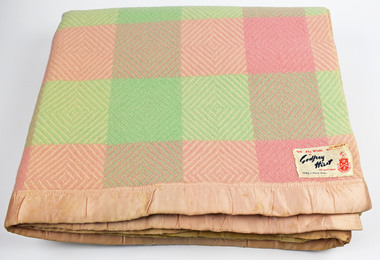
 National Wool Museum
Textile - Blanket, Godfrey Hirst, 1950s
Note from collector: I would stack plain blankets of the same base colour and arrange them by shade to make up a colour palette. It showed how particular colours were in fashion in the early decades, based mostly around depths of pastel pinks, mints, lemons and baby blues with brighter colours arriving in the 1960s then the browns and oranges in heavier tones in the 1970s. Note from collector- "For more than 100 years blankets were made all over Australia in over 100 woollen mills. My aim, is to preserve 100 examples of these wonderful pieces of history. Ten years ago I started collecting the iconic Onkaparinga travel rugs, so that on movie nights at home there would be plenty to go around. Everyone had their favourite; even the cat had his own – a small red tartan one. Keeping an eye out for those travel rugs at op-shops and markets, collectable stores and bazaars, led to noticing vintage blankets. I'd never really thought about them before or paid much attention though of course I had grown up with them at my grandmother's. When I discovered my first Laconia cream blanket with blue stripes, my eyes just went gaga. Well that was it, I was hooked and since then over 500 blankets have passed through my hands. These common, everyday items, found in all households for so many decades, were traditional engagement gifts. Pairs were prized wedding presents turning into family heirlooms. They were fashionable dressers of beds, givers of warmth, bestowers of security and reliability. The comfort found in these objects resonates with almost all of us; we grew up with them ourselves or fondly recall them in a grandparent’s home. There is no modern replacement with the integrity of these old blankets, many of them now older than most of us. They are romantic, sensible, special, familiar, nostalgic and nothing else feels so appropriate in so many situations. No offense to the great Aussie doona, but from hippie to hipster, at a music festival, picnic, campsite or couch, a vintage blanket is something coveted by all. This industry that employed tens of thousands and must have been such a huge contributor to the economy is almost completely lost now. Blanket Fever is an ode to everything that came before: the land, the sheep, the shearers, the hands, the mills, the weavers, the designers, the distributors, the department stores. To the grandparents that gave them, the people that received them, the families that kept them; thank you. I’m passionate about my collection of Australian blankets manufactured in mostly Victoria, South Australia and Tasmania from the 1930s to the end of the 1960s. The collection has blankets from each of these four decades representing the styles and fashions of their time and includes dated advertisements which help determine the eras the blankets are from." Queen Sized, dusty pink blanketGodfrey Hirst/Pure Wool Pelage Blanket/Mothproofed/Made in Australiawool, blanket, blanket fever, godfrey hirst, geelong -
 National Wool Museum
Textile - Blanket, Godfrey Hirst, 1950s
Note from collector: Godfrey Hirst Diamond blankets from the mid-1950s are always delight to find. Some of these were found in the Geelong area but one came back with me from an op shop road trip around Tasmania, another from the St Pauls op shop in Romsey. I love this pattern and find the lemon and grey colourway particularly special. Note from collector- "For more than 100 years blankets were made all over Australia in over 100 woollen mills. My aim, is to preserve 100 examples of these wonderful pieces of history. Ten years ago I started collecting the iconic Onkaparinga travel rugs, so that on movie nights at home there would be plenty to go around. Everyone had their favourite; even the cat had his own – a small red tartan one. Keeping an eye out for those travel rugs at op-shops and markets, collectable stores and bazaars, led to noticing vintage blankets. I'd never really thought about them before or paid much attention though of course I had grown up with them at my grandmother's. When I discovered my first Laconia cream blanket with blue stripes, my eyes just went gaga. Well that was it, I was hooked and since then over 500 blankets have passed through my hands. These common, everyday items, found in all households for so many decades, were traditional engagement gifts. Pairs were prized wedding presents turning into family heirlooms. They were fashionable dressers of beds, givers of warmth, bestowers of security and reliability. The comfort found in these objects resonates with almost all of us; we grew up with them ourselves or fondly recall them in a grandparent’s home. There is no modern replacement with the integrity of these old blankets, many of them now older than most of us. They are romantic, sensible, special, familiar, nostalgic and nothing else feels so appropriate in so many situations. No offense to the great Aussie doona, but from hippie to hipster, at a music festival, picnic, campsite or couch, a vintage blanket is something coveted by all. This industry that employed tens of thousands and must have been such a huge contributor to the economy is almost completely lost now. Blanket Fever is an ode to everything that came before: the land, the sheep, the shearers, the hands, the mills, the weavers, the designers, the distributors, the department stores. To the grandparents that gave them, the people that received them, the families that kept them; thank you. I’m passionate about my collection of Australian blankets manufactured in mostly Victoria, South Australia and Tasmania from the 1930s to the end of the 1960s. The collection has blankets from each of these four decades representing the styles and fashions of their time and includes dated advertisements which help determine the eras the blankets are from." Double-sized mint and cream diamond blanketAn All Wool Blanket" /By Godfrey Hirst of Geelong/100% Virgin Woolwool, blanket, blanket fever, godfrey hirst, diamond blanket -
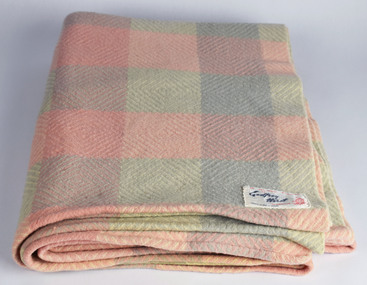
 National Wool Museum
Textile - Blanket, 1950s
Note from collector: Godfrey Hirst Diamond blankets from the mid-1950s are always delight to find. Some of these were found in the Geelong area but one came back with me from an op shop road trip around Tasmania, another from the St Pauls op shop in Romsey. I love this pattern and find the lemon and grey colourway particularly special. It was hard to let go of this one!Note from collector- "For more than 100 years blankets were made all over Australia in over 100 woollen mills. My aim, is to preserve 100 examples of these wonderful pieces of history. Ten years ago I started collecting the iconic Onkaparinga travel rugs, so that on movie nights at home there would be plenty to go around. Everyone had their favourite; even the cat had his own – a small red tartan one. Keeping an eye out for those travel rugs at op-shops and markets, collectable stores and bazaars, led to noticing vintage blankets. I'd never really thought about them before or paid much attention though of course I had grown up with them at my grandmother's. When I discovered my first Laconia cream blanket with blue stripes, my eyes just went gaga. Well that was it, I was hooked and since then over 500 blankets have passed through my hands. These common, everyday items, found in all households for so many decades, were traditional engagement gifts. Pairs were prized wedding presents turning into family heirlooms. They were fashionable dressers of beds, givers of warmth, bestowers of security and reliability. The comfort found in these objects resonates with almost all of us; we grew up with them ourselves or fondly recall them in a grandparent’s home. There is no modern replacement with the integrity of these old blankets, many of them now older than most of us. They are romantic, sensible, special, familiar, nostalgic and nothing else feels so appropriate in so many situations. No offense to the great Aussie doona, but from hippie to hipster, at a music festival, picnic, campsite or couch, a vintage blanket is something coveted by all. This industry that employed tens of thousands and must have been such a huge contributor to the economy is almost completely lost now. Blanket Fever is an ode to everything that came before: the land, the sheep, the shearers, the hands, the mills, the weavers, the designers, the distributors, the department stores. To the grandparents that gave them, the people that received them, the families that kept them; thank you. I’m passionate about my collection of Australian blankets manufactured in mostly Victoria, South Australia and Tasmania from the 1930s to the end of the 1960s. The collection has blankets from each of these four decades representing the styles and fashions of their time and includes dated advertisements which help determine the eras the blankets are from." Queen sized diamond blanket , lemon & grey "An All Wool Blanket" /By Godfrey Hirst of Geelong/100% Virgin Woolwool, blanket, blanket fever, godfrey hirst, diamond blanket, geelong -
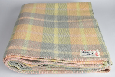
 National Wool Museum
Textile - Blanket, 1950s
Note from collector: Godfrey Hirst Diamond blankets from the mid-1950s are always delight to find. Some of these were found in the Geelong area but one came back with me from an op shop road trip around Tasmania, another from the St Pauls op shop in Romsey. I love this pattern and find the lemon and grey colourway particularly special.Note from collector- "For more than 100 years blankets were made all over Australia in over 100 woollen mills. My aim, is to preserve 100 examples of these wonderful pieces of history. Ten years ago I started collecting the iconic Onkaparinga travel rugs, so that on movie nights at home there would be plenty to go around. Everyone had their favourite; even the cat had his own – a small red tartan one. Keeping an eye out for those travel rugs at op-shops and markets, collectable stores and bazaars, led to noticing vintage blankets. I'd never really thought about them before or paid much attention though of course I had grown up with them at my grandmother's. When I discovered my first Laconia cream blanket with blue stripes, my eyes just went gaga. Well that was it, I was hooked and since then over 500 blankets have passed through my hands. These common, everyday items, found in all households for so many decades, were traditional engagement gifts. Pairs were prized wedding presents turning into family heirlooms. They were fashionable dressers of beds, givers of warmth, bestowers of security and reliability. The comfort found in these objects resonates with almost all of us; we grew up with them ourselves or fondly recall them in a grandparent’s home. There is no modern replacement with the integrity of these old blankets, many of them now older than most of us. They are romantic, sensible, special, familiar, nostalgic and nothing else feels so appropriate in so many situations. No offense to the great Aussie doona, but from hippie to hipster, at a music festival, picnic, campsite or couch, a vintage blanket is something coveted by all. This industry that employed tens of thousands and must have been such a huge contributor to the economy is almost completely lost now. Blanket Fever is an ode to everything that came before: the land, the sheep, the shearers, the hands, the mills, the weavers, the designers, the distributors, the department stores. To the grandparents that gave them, the people that received them, the families that kept them; thank you. I’m passionate about my collection of Australian blankets manufactured in mostly Victoria, South Australia and Tasmania from the 1930s to the end of the 1960s. The collection has blankets from each of these four decades representing the styles and fashions of their time and includes dated advertisements which help determine the eras the blankets are from." Double-sized, pink and mint diamond blanket"An All Wool Blanket" /By Godfrey Hirst of Geelong/100% Virgin Woolwool, blanket, blanket fever, godfrey hirst, diamond blanket, geelong -
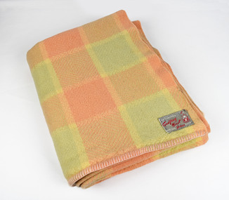
 National Wool Museum
Textile - Blanket, Godfrey Hirst, 1950s
Godfrey Hirst Diamond blankets from the mid-1950s are always delight to find. Some of these were found in the Geelong area but one came back with me from an op shop road trip around Tasmania, another from the St Pauls op shop in Romsey. I love this pattern and find the lemon and grey colourway particularly special. Note from collector- "For more than 100 years blankets were made all over Australia in over 100 woollen mills. My aim, is to preserve 100 examples of these wonderful pieces of history. Ten years ago I started collecting the iconic Onkaparinga travel rugs, so that on movie nights at home there would be plenty to go around. Everyone had their favourite; even the cat had his own – a small red tartan one. Keeping an eye out for those travel rugs at op-shops and markets, collectable stores and bazaars, led to noticing vintage blankets. I'd never really thought about them before or paid much attention though of course I had grown up with them at my grandmother's. When I discovered my first Laconia cream blanket with blue stripes, my eyes just went gaga. Well that was it, I was hooked and since then over 500 blankets have passed through my hands. These common, everyday items, found in all households for so many decades, were traditional engagement gifts. Pairs were prized wedding presents turning into family heirlooms. They were fashionable dressers of beds, givers of warmth, bestowers of security and reliability. The comfort found in these objects resonates with almost all of us; we grew up with them ourselves or fondly recall them in a grandparent’s home. There is no modern replacement with the integrity of these old blankets, many of them now older than most of us. They are romantic, sensible, special, familiar, nostalgic and nothing else feels so appropriate in so many situations. No offense to the great Aussie doona, but from hippie to hipster, at a music festival, picnic, campsite or couch, a vintage blanket is something coveted by all. This industry that employed tens of thousands and must have been such a huge contributor to the economy is almost completely lost now. Blanket Fever is an ode to everything that came before: the land, the sheep, the shearers, the hands, the mills, the weavers, the designers, the distributors, the department stores. To the grandparents that gave them, the people that received them, the families that kept them; thank you. I’m passionate about my collection of Australian blankets manufactured in mostly Victoria, South Australia and Tasmania from the 1930s to the end of the 1960s. The collection has blankets from each of these four decades representing the styles and fashions of their time and includes dated advertisements which help determine the eras the blankets are from." Diamond blanket, mint and lemon"An All Wool Blanket" /By Godfrey Hirst of Geelong/100% Virgin Woolwool, blanket, blanket fever, diamond blanket, godfrey hirst, geelong -
 National Wool Museum
Textile - Blanket, Godfrey Hirst, 1950s
Note from collector: Godfrey Hirst Diamond blankets from the mid-1950s are always delight to find. Some of these were found in the Geelong area but one came back with me from an op shop road trip around Tasmania, another from the St Pauls op shop in Romsey. I love this pattern and find the lemon and grey colourway particularly special.Note from collector- "For more than 100 years blankets were made all over Australia in over 100 woollen mills. My aim, is to preserve 100 examples of these wonderful pieces of history. Ten years ago I started collecting the iconic Onkaparinga travel rugs, so that on movie nights at home there would be plenty to go around. Everyone had their favourite; even the cat had his own – a small red tartan one. Keeping an eye out for those travel rugs at op-shops and markets, collectable stores and bazaars, led to noticing vintage blankets. I'd never really thought about them before or paid much attention though of course I had grown up with them at my grandmother's. When I discovered my first Laconia cream blanket with blue stripes, my eyes just went gaga. Well that was it, I was hooked and since then over 500 blankets have passed through my hands. These common, everyday items, found in all households for so many decades, were traditional engagement gifts. Pairs were prized wedding presents turning into family heirlooms. They were fashionable dressers of beds, givers of warmth, bestowers of security and reliability. The comfort found in these objects resonates with almost all of us; we grew up with them ourselves or fondly recall them in a grandparent’s home. There is no modern replacement with the integrity of these old blankets, many of them now older than most of us. They are romantic, sensible, special, familiar, nostalgic and nothing else feels so appropriate in so many situations. No offense to the great Aussie doona, but from hippie to hipster, at a music festival, picnic, campsite or couch, a vintage blanket is something coveted by all. This industry that employed tens of thousands and must have been such a huge contributor to the economy is almost completely lost now. Blanket Fever is an ode to everything that came before: the land, the sheep, the shearers, the hands, the mills, the weavers, the designers, the distributors, the department stores. To the grandparents that gave them, the people that received them, the families that kept them; thank you. I’m passionate about my collection of Australian blankets manufactured in mostly Victoria, South Australia and Tasmania from the 1930s to the end of the 1960s. The collection has blankets from each of these four decades representing the styles and fashions of their time and includes dated advertisements which help determine the eras the blankets are from." King-sized, pink and mint diamond blanket, ribbon edgedName tag 'O'Malley' sewn above label/"An All Wool Blanket" /By Godfrey Hirst of Geelong/100% Virgin Woolwool, blanket, blanket fever, diamond blanket, godfrey hirst, geelong -
 National Wool Museum
Textile - Blanket, Godfrey Hirst, 1950s
Collector says: Godfrey Hirst Diamond blankets from the mid-1950s are always delight to find. Some of these were found in the Geelong area but one came back with me from an op shop road trip around Tasmania, another from the St Pauls op shop in Romsey. I love this pattern and find the lemon and grey colourway particularly special. Note from collector- "For more than 100 years blankets were made all over Australia in over 100 woollen mills. My aim, is to preserve 100 examples of these wonderful pieces of history. Ten years ago I started collecting the iconic Onkaparinga travel rugs, so that on movie nights at home there would be plenty to go around. Everyone had their favourite; even the cat had his own – a small red tartan one. Keeping an eye out for those travel rugs at op-shops and markets, collectable stores and bazaars, led to noticing vintage blankets. I'd never really thought about them before or paid much attention though of course I had grown up with them at my grandmother's. When I discovered my first Laconia cream blanket with blue stripes, my eyes just went gaga. Well that was it, I was hooked and since then over 500 blankets have passed through my hands. These common, everyday items, found in all households for so many decades, were traditional engagement gifts. Pairs were prized wedding presents turning into family heirlooms. They were fashionable dressers of beds, givers of warmth, bestowers of security and reliability. The comfort found in these objects resonates with almost all of us; we grew up with them ourselves or fondly recall them in a grandparent’s home. There is no modern replacement with the integrity of these old blankets, many of them now older than most of us. They are romantic, sensible, special, familiar, nostalgic and nothing else feels so appropriate in so many situations. No offense to the great Aussie doona, but from hippie to hipster, at a music festival, picnic, campsite or couch, a vintage blanket is something coveted by all. This industry that employed tens of thousands and must have been such a huge contributor to the economy is almost completely lost now. Blanket Fever is an ode to everything that came before: the land, the sheep, the shearers, the hands, the mills, the weavers, the designers, the distributors, the department stores. To the grandparents that gave them, the people that received them, the families that kept them; thank you. I’m passionate about my collection of Australian blankets manufactured in mostly Victoria, South Australia and Tasmania from the 1930s to the end of the 1960s. The collection has blankets from each of these four decades representing the styles and fashions of their time and includes dated advertisements which help determine the eras the blankets are from." King sized Diamond blanket, pink, mint and lemon Mothproofed/Godfrey Hirst/Pure Wool Pelage Blanketwool, blanket, blanket fever, diamond blanket, godfrey hirst, geelong -
 National Wool Museum
Textile - Blanket, Godfrey Hirst, 1950s
Collector says: Godfrey Hirst Diamond blankets from the mid-1950s are always delight to find. Some of these were found in the Geelong area but one came back with me from an op shop road trip around Tasmania, another from the St Pauls op shop in Romsey. I love this pattern and find the lemon and grey colourway particularly special. Note from collector- "For more than 100 years blankets were made all over Australia in over 100 woollen mills. My aim, is to preserve 100 examples of these wonderful pieces of history. Ten years ago I started collecting the iconic Onkaparinga travel rugs, so that on movie nights at home there would be plenty to go around. Everyone had their favourite; even the cat had his own – a small red tartan one. Keeping an eye out for those travel rugs at op-shops and markets, collectable stores and bazaars, led to noticing vintage blankets. I'd never really thought about them before or paid much attention though of course I had grown up with them at my grandmother's. When I discovered my first Laconia cream blanket with blue stripes, my eyes just went gaga. Well that was it, I was hooked and since then over 500 blankets have passed through my hands. These common, everyday items, found in all households for so many decades, were traditional engagement gifts. Pairs were prized wedding presents turning into family heirlooms. They were fashionable dressers of beds, givers of warmth, bestowers of security and reliability. The comfort found in these objects resonates with almost all of us; we grew up with them ourselves or fondly recall them in a grandparent’s home. There is no modern replacement with the integrity of these old blankets, many of them now older than most of us. They are romantic, sensible, special, familiar, nostalgic and nothing else feels so appropriate in so many situations. No offense to the great Aussie doona, but from hippie to hipster, at a music festival, picnic, campsite or couch, a vintage blanket is something coveted by all. This industry that employed tens of thousands and must have been such a huge contributor to the economy is almost completely lost now. Blanket Fever is an ode to everything that came before: the land, the sheep, the shearers, the hands, the mills, the weavers, the designers, the distributors, the department stores. To the grandparents that gave them, the people that received them, the families that kept them; thank you. I’m passionate about my collection of Australian blankets manufactured in mostly Victoria, South Australia and Tasmania from the 1930s to the end of the 1960s. The collection has blankets from each of these four decades representing the styles and fashions of their time and includes dated advertisements which help determine the eras the blankets are from." Godfrey Hirst diamond blanket in pink, grey and lemon"An All Wool Blanket" /By Godfrey Hirst of Geelong/100% Virgin Woolwool, blanket, blanket fever, diamond blanket, godfrey hirst, geelong -
 National Wool Museum
Textile - Blanket, Godfrey Hirst, 1950s
Collector says: Godfrey Hirst Diamond blankets from the mid-1950s are always delight to find. Some of these were found in the Geelong area but one came back with me from an op shop road trip around Tasmania, another from the St Pauls op shop in Romsey. I love this pattern and find the lemon and grey colourway particularly special. Note from collector- "For more than 100 years blankets were made all over Australia in over 100 woollen mills. My aim, is to preserve 100 examples of these wonderful pieces of history. Ten years ago I started collecting the iconic Onkaparinga travel rugs, so that on movie nights at home there would be plenty to go around. Everyone had their favourite; even the cat had his own – a small red tartan one. Keeping an eye out for those travel rugs at op-shops and markets, collectable stores and bazaars, led to noticing vintage blankets. I'd never really thought about them before or paid much attention though of course I had grown up with them at my grandmother's. When I discovered my first Laconia cream blanket with blue stripes, my eyes just went gaga. Well that was it, I was hooked and since then over 500 blankets have passed through my hands. These common, everyday items, found in all households for so many decades, were traditional engagement gifts. Pairs were prized wedding presents turning into family heirlooms. They were fashionable dressers of beds, givers of warmth, bestowers of security and reliability. The comfort found in these objects resonates with almost all of us; we grew up with them ourselves or fondly recall them in a grandparent’s home. There is no modern replacement with the integrity of these old blankets, many of them now older than most of us. They are romantic, sensible, special, familiar, nostalgic and nothing else feels so appropriate in so many situations. No offense to the great Aussie doona, but from hippie to hipster, at a music festival, picnic, campsite or couch, a vintage blanket is something coveted by all. This industry that employed tens of thousands and must have been such a huge contributor to the economy is almost completely lost now. Blanket Fever is an ode to everything that came before: the land, the sheep, the shearers, the hands, the mills, the weavers, the designers, the distributors, the department stores. To the grandparents that gave them, the people that received them, the families that kept them; thank you. I’m passionate about my collection of Australian blankets manufactured in mostly Victoria, South Australia and Tasmania from the 1930s to the end of the 1960s. The collection has blankets from each of these four decades representing the styles and fashions of their time and includes dated advertisements which help determine the eras the blankets are from." Godfrey Hirst Diamond blanket in pink and grey"An All Wool Blanket" /By Godfrey Hirst of Geelong/100% Virgin Woolwool, blanket, blanket fever, diamond blanket, godfrey hirst, geelong