Showing 1400 items
matching allotments
-
 Stawell Historical Society Inc
Map, Township of Stawell
B/W map of Stawell Surveyed by Easton Johnston Contract surveyor Scale in Chains. Showing Special Allotments Reefs, Pleasant Creek Parish of Stawell. Map No L4000 -
 The Beechworth Burke Museum Research Collection
Card (Series) - Index Card, George Tibbits, William Street, Beechworth, 1976
George Tibbits, University of Melbourne. Faculty of Architecture, Building and Town & Regional PlanningIndex system that support the research for Beechworth : historical reconstruction / [by] George Tibbits ... [et al]Arranged by street names of BeechworthEach index card includes: street name and number of property, image of property, allotment and section number, property owners and dates of ownership, description of the property according to rate records, property floor plan with dimensions.beechworth, george tibbitsbeechworth, george tibbits -
 Ringwood and District Historical Society
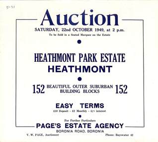
Flyer, Land Auction Sale Brochure, Heathmont Park Estate, Heathmont, Vic. - 1949
Double sided multi-fold advertisement for auction sale of residential allotments, including summary of subdivision features and local facilities. Auction on Saturday, 22nd October, 1949, at 2 p.m.Subdivision includes Great Ryrie Street, Erica Crescent, Neil Street, Frances Street, Viviani Crescent, and Canterbury Road. Agent - Page's Estate Agency, Boronia Road, Boronia. Phone Bayswater 42. -
 Ringwood and District Historical Society
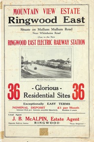
Flyer, Land Sale Brochure, Mountain View Estate, Ringwood East, Vic. - 1923
Bi-fold advertisement for sale of residential allotments, including photographs, map, and summary of subdivision features and local facilities. Undated handwritten notation reads "streets don't exist today".Subdivision layout includes Mullum Mullum Road, Rangeview Avenue, Press Avenue, and Mountview Avenue. Local Agent - J.B. McAlpin, Opposite Railway Station, Ringwood, Phone Ringwood 7. Vendor - T.J. Press, Builder, "Monterey", Second Avenue, Kew, Telephone Haw. 3428. -
 Ringwood and District Historical Society
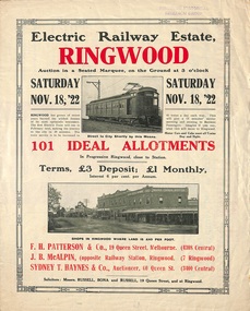
Flyer, Land Sale Auction Brochure, Electric Railway Estate, Ringwood, Vic. - 1922
Bi-folded single sheet with black and red print both sides advertising auction of allotments on Saturday, November 18, 1922, including details of subdivision features and local facilities. Subdivision includes Bedford Road, Williams Grove, Campbell Street, Myrtle Avenue, George Street, and Henry Street. Agents - F.H. Patterson & Co., 19 Queen Street, Melbourne, Tel. 4308 Central, J.B. McAlpin, Opposite Railway Station, Ringwood, Tel 7 Ringwood, SYDNEY T. Haynes & Co., Auctioneer, 60 Queen Street, Melbourne, Tel 3400 Central. -
Bendigo Historical Society Inc.
Document - ALLOTMENTS SOLD BY PUBLIC AUCTION 1ST JUNE 1837 MELBOURNE
Large copy of the first land auction in Melbourne on June the first 1837. Melbourne - Port Phillip, allotments sold by public auction with the name of the purchasers and of the prices. June 1st 1837.victoria, history, land -
 Whitehorse Historical Society Inc.
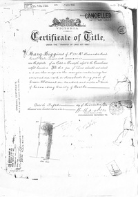
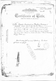
Certificate - Land Title document, Crown Allotment, 5/11/1909
Certificate of Title dated 5/11/1909 covering land in Shady Grove Nunawading purchased by Mary Higgins. Crown Land Allotment No. 116 Parish of Nunawading County of Bourke.land titles, higgins, mary, holmes, dave, shady grove nunawading no.76, helen -
 Whitehorse Historical Society Inc.
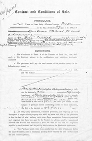
Document, Contract and conditions of sale, 1909
Copy of contract dated 19 April 1909 between the Freehold Investment and Banking Company of Australia Ltd and Julius Draeger. Portion of land allotment 94 known as Glebe Paddock.non-fictionland subdivision, glebe paddock, draeger, carl julius otto, freehold investment and banking company of australia ltd, t. r. b. morton & son -
 Kew Historical Society Inc
Plan, J R Mathers & McMillan, Sackville, Thomas & Lytton Streets, Kew, Twentieth Century
The Kew Historical Society's map collection includes a substantial number of real estate subdivision plans, mainly of Kew but also of surrounding suburbs in Melbourne. Most of the subdivision plans date from the 1920s and 1930s when the districts old homes and local farmland were being split up to accommodate residential growth in the postwar period. These early plans were assembled by a local firm, Jas R Mather & McMillan, which had an office in Cotham Road. Many of the plans, and sometimes photos, were annotated by the agents.Subdivision plans are historically important documents used as evidence for the growth of suburbs in Australia. They frequently provide information about when the land was sold as well as evidence relating to surveyors and real estate and financial agents. The numerous subdivision plans in the Kew Historical Society's collection represent working documents, ranging from the initial sketches made in planning a subdivision to printed plans on which auctioneers or agents listed the prices for which individual lots were sold. In a number of cases, the reverse of a subdivision plan in the collection includes a photograph of a house that was also for sale by the agent. These photographs provide significant heritage information relating house design and decoration, fencing and household gardens.The photograph may also be aesthetically significant depending on the importance of the photographic atelier.Lithographed subdivision plan for an un-named estate with 28 allotments facing Lytton, Sackville and Thomas Streets in Kew. The land would have originally formed part of the Dumaresq Estate. subdivision plans - kew, lytton street, sackville street, thomas street - kew -
Clunes Museum
Map - CLUNES 1987, CHARLES FENTON, 1987
.1 .2 A MAP OF CLUNES TOWNSHIP - ORIGINAL AND COPY - 1987. ALL STREETS AND BIRCH'S CREEK MARKED WITH ALLOTMENT NUMBERS. .3 SAME MAP SHOWING PATH OF BUSHFIRE IN 1944CLUNES 1987local history, document, maps, clunes township -
 Ringwood and District Historical Society
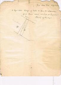
Document - Subdivision Map, Part of Crown Sections 18, 19, 24 & 25, Parish of Warrandyte, County of Evelyn, Vol 5228 Fol 472 - 1926. (Park Orchards, Victoria)
A3 and A4 sized photocopies showing map section of land title showing streets, easements and allotment numbers, some with handwritten names and pricing notations circa mid 1950s.Map includes Valley Road, Granard Avenue, Park Road, Arundel Avenue, Hylton Avenue, Aviemore Avenue, Bowmore Avenue, Hopetoun Road, Colin Avenue, Daintree Avenue, Brucedale Crescent, Feversham Avenue, Ennismore Crescent, Iona Grove, Elgin Crescent and Gosford Crescent, Park Orchards, Victoria. -
 The Beechworth Burke Museum Research Collection
Card (Series) - Index Card, George Tibbits, Cnr William and Last Streets, Beechworth, 1976
George Tibbits, University of Melbourne. Faculty of Architecture, Building and Town & Regional PlanningIndex system that support the research for Beechworth : historical reconstruction / [by] George Tibbits ... [et al]Arranged by street names of BeechworthEach index card includes: street name and number of property, image of property, allotment and section number, property owners and dates of ownership, description of the property according to rate records, property floor plan with dimensions.beechworth, george tibbitsbeechworth, george tibbits -
 Greensborough Historical Society
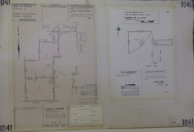
Planning Document, Subdivision Plan #1041. Elder Street Greensborough, 20/04/1983
Plan of Consolidation of Allotments 3 and 4 Brixton Avenue and Plan of Subdivision for Elder Street. An example of hard copy subdivision plans from the Greensborough area. Mainly from the Shire of Diamond Valley era (1964-1994).Plan (2 sheets) mounted on heavy card.Stamped and handwritten Council permissions, dates and other details.subdivision plans, elder street, brixton avenue -
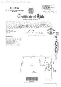 Ringwood and District Historical Society
Document - Certificate of Title and Maroondah Heritage Study, "Elouera", 59 Bemboka Road, Warranwood, Victoria, previously part of Crown Section 20, Parish of Warrandyte, County of Evelyn - 4th February, 1987
Property subsequently subdivided into residential allotments with formation of Aspen Court, Warranwood, circa 2010.A4 copies of Landata Victoria documents - Vol 9725 Fol 210 derived from Vol 9701 Vol 469, and 2-page Heritage Study report.Ian Vance Lloyd and June Josephine Lloyd are joint proprietors of an estate in fee simple - Lot 4 on Plan of Subdivision no.204137B shown on the map. Subdivision includes Bemboka Road. Encumbrance E-1 later extended through Lot 4 as Aspen Court. Transfer - Proprietor June Josephine Lloyd - 29 July, 1993. Documents include 2-page Heritage report for study conducted prior to subsequent Aspen Court residential development circa 2010. -
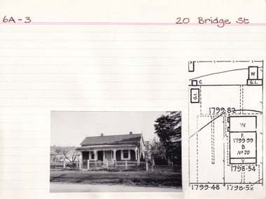 The Beechworth Burke Museum Research Collection
Card (Series) - Index Card, George Tibbits, 20 Bridge Street, Beechworth, 1976
George Tibbits, University of Melbourne. Faculty of Architecture, Building and Town & Regional PlanningIndex system that support the research for Beechworth : historical reconstruction / [by] George Tibbits ... [et al]Arranged by street names of BeechworthEach index card includes: street name and number of property, image of property, allotment and section number, property owners and dates of ownership, description of the property according to rate records, property floor plan with dimensions.beechworth, george tibbitsbeechworth, george tibbits -
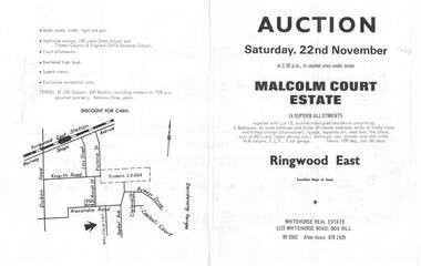 Ringwood and District Historical Society
Flyer, Land Auction Brochure, Malcolm Court Estate, Ringwood East, Vic. - 1969
Bi-folded single sheet with black print both sides advertising Auction on Saturday, 22nd November, 1969. Details include location map, vendor terms, subdivision features and local facilities. Centre page shows allotment numbers and property dimensions. Agent - Whitehorse Real Estate, 1123 Whitehorse Road, Box Hill, (Phone) 890502, After hours 8781429. Separate copy of map with handwritten sale notations for some allotments.LP 859686 -
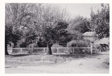 The Beechworth Burke Museum Research Collection
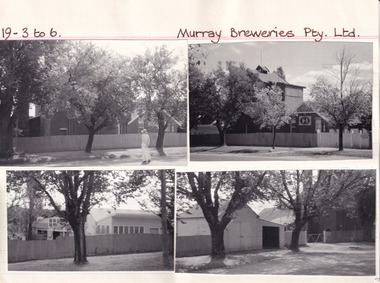
Photograph (Series), George Tibbits, Fences at 39 Kars Street and 32 Finch Street, 1976
George Tibbits, University of Melbourne. Faculty of Architecture, Building and Town & Regional PlanningIndex system that support the research for Beechworth : historical reconstruction / [by] George Tibbits ... [et al]Arranged by street names of BeechworthEach index card includes: street name and number of property, image of property, allotment and section number, property owners and dates of ownership, description of the property according to rate records, property floor plan with dimensions.beechworth, george tibbitsbeechworth, george tibbits -
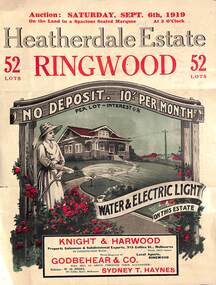 Ringwood and District Historical Society
Pamphlet - Land Auction Brochure, Heatherdale Estate, Ringwood, Victoria - 1919
Double sided leaflet advertising subdivision site, layout of streets and allotments, summary of local features and services and terms of sale. Inset photographs of local views and residence of F.W. Purches on the Estate.Auction Saturday September 6th, 1919. 52 Lots. Subdivision includes White Horse Road, Witt Street, Mitcham, Station Street (later Victory Street, Mitcham). (Railway Avenue marked on the map did not eventuate). Agents - Knight & Harwood, 315 Collins Street, Melbourne in conjunction with Godbehear & Co, Phone Ringwood 49, selling through their auctioneer - Sydney T. Haynes. Solicitor W.H. Peers, 395 Collins Street, Melbourne. -
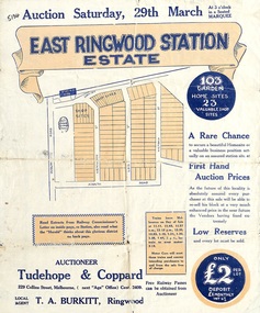 Ringwood and District Historical Society
Flyer, Land Sale Auction Brochure, East Ringwood Station Estate - 1924
Bi-folded double sided sheet with yellow and blue print advertising auction of retail and residential allotments on Saturday, 29 March (1924), including details of subdivision features and local facilities. Subdivision includes Station Street, Wenwood Street, Lois Street, Victoria Street. Auctioneer - Tudehope & Coppard, 229 Collins Street, Melbourne, Tel. Central 2409, in conjunction with local agent, T.A. Burkeitt, Ringwood, Tel. Ringwood 157. -
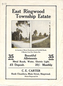 Ringwood and District Historical Society
Flyer, Subdivisional Land Sale Brochure, East Ringwood Township Estate, Vic. - 1923
Bi-folded double sided land subdivision sale advertisement with location map and summary of local facilities and services. Includes two additional images of allotment plan with subsequent handwritten notations.Subdivision includes Mount Dandenong Road, Grey Street, and Eastfield Road. Agent - C.E. Carter, Bank Chambers, Main Street, Ringwood. Phone Ringwood 24. -
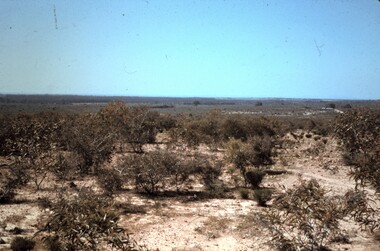 Bendigo Historical Society Inc.
Slide - PETER ELLIS COLLECTION: SLIDE, May 1970 - Jan 1972
Coloured slide transparency. Image is of a bush area. There is low growing scrub in the foreground. The words, Allotment 18 Bagshot looking east to 13 of 15 Bagshot are handwritten across the bottom border.Kodachrome Transparencyslide, bendigo, bendigo institute of technology -
 Whitehorse Historical Society Inc.
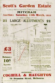
Document, Scott's Garden Estate, 1915
Brochure of Scott's Garden EstateBrochure of Scott's Garden Estate consisting of 21 large allotments owned by Mrs. E.E. Scott, corner Victoria Street and Scott Street, Mitcham. Also includes New Street, Mitcham. Brochure of Scott's Garden Estate scott, emma elizabeth, coghill & haughton, daly, hall & davey, scott's garden estate, scott street mitcham, victoria street mitcham, new street, mitcham -
 Whitehorse Historical Society Inc.
Certificate - Land Title Document, Crown Allotment, 24/9/1885
Certificate of Title dated 4/9/1885 covering land in Shady Grove Nunawading purchased by The Freehold Investment and Banking Company. Crown Allotment No. 116 Parish of Nunawading County of Bourkeland titles, shady grove nunawading no. 76, crown land allotment no. 116, the freehold investment and banking company of australia ltd., higgins, mary, holmes, dave, wilson, david duncan butchart, helen -
Bendigo Historical Society Inc.
Map - PANNOOMILLOO : COUNTY OF BENDIGO, 1957
Map. Pannoomilloo, County of Bendigo, Pannoobamawm, Milloo, Warragamba, Diggorra, Property Allotments. Drawn and Reproduced at the Department of Lands and Survey,1957. Price 2/-. (number 412 in Map Cupboard 1 ).W.M. Houston, Government Printer, Melbourne.bendigo, hospital -
 Bendigo Historical Society Inc.
Document - H. A. & S. R. WILKINSON COLLECTION: HAND WRITTEN NOTE
Hand written note. Volume 1200, folio 239806. Schroeder part Crown allotment 18 section H Eaglehawk. A drawing of a block of land also the name James Stewart on the left.organization, business, h.a. & s.r wilkinson real estate -
 Ringwood and District Historical Society
Document - Plan of Subdivision, Part of Crown Allotment 31B, Parish of Warrandyte - 1965
Map showing residential allotments numbered 1, 2, 4 and 5, on Through Road, Ringwood, Vic., with property dimensions, including weatherboard house and galvanised iron garage on lot 2.Kirkpatrick & Webber, Licensed Surveyors, Civil Engineers & Town Planners, Maroondah Highway, Ringwood, Telephone 8700321. Ref 3438C. Date 4th December, 1964. Amended 19th July, 1965. Notation: "The land coloured blue is a drainage and sewerage easement. Levels are to Board of Works Datum. Lot number 3 has been omitted." -
Clunes Museum
Document - LETTER OF ALLOTMENT, 4TH APRIL 1924
LETTER OF ALLOTMENT, SIGNED BY A.EVANS SECRETARY, FOR TWENTY FIVE ORDINARY SHARES OF 1 POUND EACH.LETTER OF ALLOMENT FOR ISSUE OF SHARES IN CLUNES KNITTING & MANUFACTURING COMPANY LIMITED, ISSUED TO MISS SHRIGLEYlocal history, clunes knitting mill -
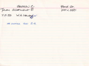 The Beechworth Burke Museum Research Collection
Card - Index Card, George Tibbits, Ford Street, Beechworth, 1976
Property - Ford Street (Star Hotel), Beechworth - Section 2, Town Allotment 5 - 100' x 250' Ownership details and history - 7 Sept 1853 - W.H. Neuber Architectural - Note: for all entries see Section 2, Town Allotment 4 Index Card - Brian Pump and Tony Dugan - Photographers beechworth, george tibbits -
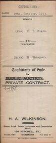 Bendigo Historical Society Inc.
Document - H.A. & S.R. WILKINSON COLLECTION: CONTRACT OF SALE
Conditions of sale by private contract dated 19th October, 1933 between Mrs. P.I. Clark (seller) and Miss M. Thompson (buyer) for land situate McIvor Road, Bendigo being lots 2,5 and 6 on plan of subdivision No. 13539 and being Crown allotment 196 and parts of Crown allotments 151,195 and 270A section H described in certificate of title volume 5756 folio 1151098, together with all fences and erections thereon. Price 150 pounds.organization, business, h.a. & s.r wilkinson real estate