Showing 287 items
matching board of land and works
-
 Kew Historical Society Inc
Map, MMBW, MMBW Plan No.117 Heidelberg & Kew, 1900-1910
The Melbourne and Metropolitan Board of Works (MMBW) was established by an act of the Victorian Parliament in 1890 to prepare for and to implement a sewerage and water reticulation system across what was then inner Melbourne, its surrounding and middle distance suburbs, including Kew. The MMBW was disbanded in 1991.The map collection of the Kew Historical Society has at its core the historic maps assembled and originally stored in the City Engineer's Department of the City of Kew. These include maps in a number of scales. The vast majority of maps were produced by the MMBW in the first two decades of the twentieth century, and are solid working maps, backed by linen for durability. These maps are historically significant to Kew, the City of Boroondara and to the history of the development of state utilities in Victoria. A number of the Kew maps have additional details added by former municipal officers, including the levels reached by various floods. As these were working documents, information was added to them long after the period of their initial production and distribution.Early map of part of the Borough of Kew, created in the early twentieth century, at a scale 160 ft to 1 inch. The map covers what was then the north eastern part of Kew showing the natural landscape and limited development on the south side of the Yarra River. In the Kew section, south of the river, the land is occupied currently by the Greenacres and Kew Golf Clubs. The map shows the extent of urban development by that time and the outlines of the few built structures in the municipality. The height above sea level of all parts of the landscape are indicated numerically in feet. Contour lines and the levels of historic floods were added in ink to the map at a later stage. MELBOURNE AND METROPOLITAN BOARD OF WORKS / PLAN NO. 117 / HEIDELBERG & KEW melbourne & metropolitan board of works, mmbw maps, borough of kew, cartography, mmbw plan no. 117, kew (vic.) -- maps, heidelberg (vic.) -- maps -
 Wodonga & District Historical Society Inc
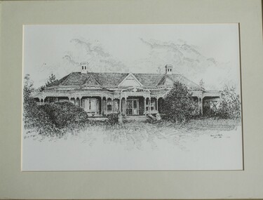
Drawing - Cambourne House, Kevin P. Clark, 1984
Cambourne homestead was built by 1903 for Rebecca S. Carkeek, who purchased the property in Wodonga in 1899. Cambourne is situated on the original Wodonga run which was established in 1836. The township of Belvoir, later renamed as Wodonga. In 1855 the pre-emptive right of 171 acres of the Wodonga run was granted and sold the following year. The allotments on which the five-acre Cambourne property developed, were purchased in 1873 and 1876, coinciding with the opening of the railway from Melbourne. The property was purchased by Rebecca Carkeek in June 1899, wife of William Carkeek, publican of Wodonga and shire councillor. Local architects Gordon and Gordon have been credited with the design of Cambourne. The house at Cambourne was built at some stage between 1900 and 1903 as a large single storey homestead. It was constructed in red brick with corrugated iron roof and encircling verandah. Cambourne is a probable work of architects Gordon and Gordon, it is amongst their best preserved and one of their few surviving buildings in Victoria. Today Cambourne remains on a reduced allotment due to the acquisition of land in 1972 by the Country Roads Board and in 2006 by Vic Roads for road works adjacent to the property.This drawing is significant as a representation of Cambourne in Wodonga. Cambourne is of historical significance due to its links with the early settlement of the district and as an example of closer settlement which occurred in regional centres of the State. Cambourne, Wodonga is also of architectural significance as a largely intact late Victorian style house with elaborate decorative cast iron work and distinctive transverse plan. As a probable work of architects Gordon and Gordon, it is amongst their best preserved and one of their few surviving buildings in Victoria. A framed drawing of historic home, Cambourne in Wodonga. The drawing has been mounted and framed.On bottom right corner" Kevin P. Clark 1984"cambourne wodonga, gordon and gordon architects, historic buildings wodonga, heritage buildings wodonga -
 Wodonga & District Historical Society Inc
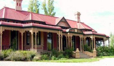
Photograph - Cambourne House
Cambourne homestead was built by 1903 for Rebecca S. Carkeek, who purchased the property in Wodonga in 1899. Cambourne is situated on the original Wodonga Run which was established in 1836. In 1855 the pre-emptive right of 171 acres of the Wodonga Run was granted and sold the following year. The allotments on which the five-acre Cambourne property developed, were purchased in 1873 and 1876, coinciding with the opening of the Railway from Melbourne. The property was purchased by Rebecca Carkeek in June 1899, wife of William Carkeek, Publican of Wodonga and Shire Councillor. Local architects Gordon and Gordon have been credited with the design of Cambourne. The house at Cambourne was built at some stage between 1900 and 1903 as a large single storey homestead. It was constructed in red brick with corrugated iron roof and encircling verandah. Cambourne is a probable work of architects Gordon and Gordon, it is amongst their best preserved and one of their few surviving buildings in Victoria. Today Cambourne remains on a reduced allotment due to the acquisition of land in 1972 by the Country Roads Board and in 2006 by Vic Roads for road works adjacent to the property.Cambourne, Wodonga is of architectural and historical significance to the State of Victoria.A set of coloured photos depicting Cambourne in Wodonga. Part of a collection documented a heritage listed pioneer home.cambourne wodonga, cambourne homestead wodonga, historic buildings wodonga -
 Wodonga & District Historical Society Inc
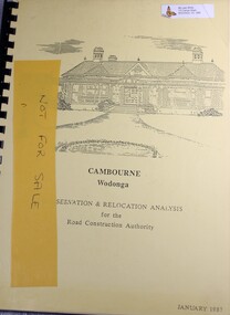
Booklet - Cambourne Wodonga : Conservation & Relocation Analysis for the Road Construction Authority, John & Thurley O'Conner, 1987
Research paper into the viability of relocating Cambourne Homestead in 2006 in order to make way for the widening and upgrade of the Hume Highway.non-fictionResearch paper into the viability of relocating Cambourne Homestead in 2006 in order to make way for the widening and upgrade of the Hume Highway. cambourne homestead wodonga, heritage building wodonga, carkeek family, potter family, building relocation -
 Whitehorse Historical Society Inc.
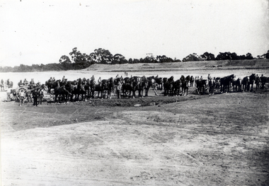
Photograph - Black & white photograph, Clearing Land for Mitcham Reservoir
Black and white photo of Teams of Horses clearing Land for M.M.B.W. Reservoir at Mitcham.meagher, ray, melbourne and metropolitan board of works, mitcham reservoir -
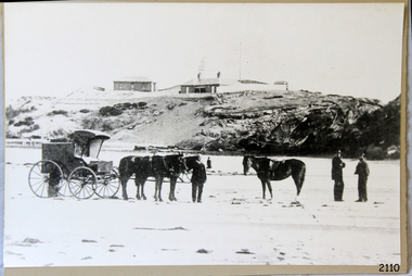 Flagstaff Hill Maritime Museum and Village
Photograph - Scene - Warrnambool, C. 1854-1871
This is an image of the Warrnambool Lighthouse Complex on Middle Island in 1854. The Store, Lighthouse Keeper's Quarters, Lighthouse and Flagstaff are in the background. The foreground shows a covered buggy drawn by two horses and a person in attendance, and another wheeled vehicle behind it with a figure nearby. There is a saddled horse to the right with two males in conversation nearby. The ground is soft, perhaps the riverbed or sandy shore. THE LIGHTHOUSE KEEPERS Lighthouse Keepers were responsible for keeping their Lighthouse’s lights shining at night. They kept a lookout for passing vessels and changes in weather. They were expected to clean, polish and maintain the equipment and buildings. They kept regular and detailed records of who was on watch, and the time the light was lit, trimmed and extinguished. They kept a journal about other events that occurred. They keep regular, accurate Meteorological Logs. It was expected that they were competent in Morse code signalling. They would be called to help in times of disasters and shipwrecks and to give official statements about these events. Many Lighthouse Keepers also volunteered as members of the lifeboat crew. The Lady Bay lighthouses were officially classified as small, so the Keepers had the official titles of Senior Assistant Lighthouse Keeper and Assistant Lighthouse Keeper. They were employed by the Public Service and paid rent to live in the Lighthouse Quarters. They were compulsorily retired at the age of 60, with most receiving a superannuation payment. Despite their time-consuming duties, there was time to follow hobbies and crafts such as growing vegetables, playing musical instruments, making models of buildings including lighthouses, and crafting furniture pieces. An example of a keeper’s skills is the carved fire screen made by /assistant Keeper Thomas Hope in the late 19th century and displayed in the Lighthouse Keeper’s cottage at Flagstaff Hill. Both Alexander and Farncombe had served under Senior Keeper Robert Deverell, who was the first and only Senior Lighthouse Keeper at the Middle Island Complex. John Alexander was the Assistant Keeper in the 1850s. Andrew Farncombe was the last Assistant Keeper at Middle Island, serving there with his family from 1864 to 1871. During 1871 and 1872 the Lighthouse Complex was moved to Flagstaff Hill on Merri Street. Farncombe and Deverell then became the first Keepers and occupants of the Lady Bay Lighthouse Complex at Flagstaff Hill. They continued their service together; overall, Deverell served from 1859 to 1885 and Farncombe from 1864 to 1974. WARRNAMBOOL'S LADY BAY LIGHTHOUSE COMPLEX - The original Lighthouse Complex was built on Middle Island in 1858-1859 then transferred stone-by-stone to Flagstaff Hill in 1871. The Complex comprised the Lighthouse, the Lighthouse Keepers’ Quarters and a Privy. The bluestone Keeper’s Quarters was a cottage divided into two compartments, one for the Senior Keeper and his family, the other for the Assistant Keeper and his family. The bluestone Store was divided into three; a store, a workshop, and an oil store (or office). The Privy comprised a small building also divided into two separate, back-to-back toilets, one for each Keeper and his family. In the 1970s the Flagstaff Hill Planning Board was set up under the chairmanship of John Lindsay. The Board was to make recommendations to the Warrnambool City Council regarding the use of the buildings and the rest of the Crown Land on the site. The Flagstaff Hill Maritime Village opened in 1975 and began renovating the Cottage in stages, during which time evidence of a 1920s fire was found in the eastern section of the cottage. Additions of a porch on the west and a washroom on the east were made in the 1980s. The western part of the building is now a Shipwreck Museum and the east has returned to a late 19th-century Lighthouse Keeper’s cottage and includes the screen made by Assistant Lighthouse Keeper Thomas Hope in the late 19th century. Hope served two periods of time at the Lighthouse. This photograph is significant as a visual record of the original Warrnambool Lighthouse Complex on Middle Island, the origin of what is now the Lady Bay Lighthouse Complex. The photograph is significant for its connection to the Complex, which is now listed on the Victorian Heritage Register, H1520, for being of historical, scientific (technological) and architectural significance to the State of Victoria. The Complex is significant as an example of early colonial development. The photograph is significant for its connection with the important navigational function of the Lighthouses, a function still being performed to this day. The photograph is also significant as it shows an example of buildings organised by the Public Works Department in Victoria in the mid-to-late 19th century. The structures tare still stand strong. Photograph of horses, a buggy and three gentlemen in the foreground and the background shows a lighthouse and accompanying buildings. Printed in black and white. (Another two horse-drawn vehicles are partially visible). The subject is the Lighthouse Complex on Middle Island, Warrnambool, dated between 1854 and 1871.An inscription is handwritten in black pen on the back of the mounting board."The lighthouse and accompanying buildings were / established on Middle Island in 1854, as this / picture shows. In 1871 they were moved to their / present site on Flagstaff Hill."flagstaff hill, flagstaff hill maritime museum, flagstaff hill maritime village, warrnambool, maritime museum, shipwreck coast, lighthouse keeper's cottage, lighthouse residence, lighthouse, chart room, quarters, privy, middle island, beach lighthouse, obelisk, lighthouse complex, lady bay complex, warrnambool port, warrnambool harbour, lady bay, keepers, lighthouse keeper, upper lighthouse, lower lighthouse, assistant keeper, ports and harbours, cottage, meteorological record, 1854, 1871 -
 Eltham District Historical Society Inc
Photograph - Digital Photograph, Alan King, Garden Hill, Eltham-Yarra Glen Road, Kangaroo Ground, 3 February 2008
The original house was built around 1850 was one of Kangaroo Ground's earliest homes, part of which remains today. Built by Scottish farmer Andrew Harkness who acquired the property in 1849 at the top of the hill with magnificent panoramic views as far as Kinglake, the same year he married Sarah Oswin. The property was known as Garden Hill from at least 1865. Andrew and Sarah had four sons and five daughters. Harkness was a founder of the Kangaroo Ground School and one of the first to suggest establishing the Eltham District Road Board (1858-71) of which he was a member, the pre-cursor to the Shire of Eltham (1871-1994). He was also a Trustee of the Kangaroo Ground Cemetery. His daughter Fanny married farmer Alexander White who purchased the property in 1893. Alexander White died in 1906 and ownership transferred to Fanny White. Son, Robert White was a Councillor of the Shire of Eltham at the time the Shire acquired two acres of land on the adjacent property from the Mess brothers for the creation of the Shire of Eltham Memorial Park (1921) in which the Shire of Eltham War Memoirial tower was erected (1926). Fanny White donated a small section of land from the Garden Hill property to facilitate entry access to the park. The White family sold the property to Sir Herbert Gepp in 1925. Covered under Heritage Overlay, Nillumbik Planning Scheme. Published: Nillumbik Now and Then / Marguerite Marshall 2008; photographs Alan King with Marguerite Marshall.; p29 Garden Hill, on Yarra Glen Road, Kangaroo Ground, near the War Memorial is well named. The old house and gardens overlook a magnificent panorama extending to Kinglake. The original house, built around 1850, was one of Kangaroo Ground’s earliest, and part of it remains in today’s timber house. The house was built by the early and prominent settler Andrew Harkness. Later it was occupied for a long time by Sir Herbert Gepp, renowned Australia wide.1 Harkness and Gepp are buried in the Kangaroo Ground Cemetery. Scottish farmer Harkness, who was born in 1817, acquired this property in 18492 and he and his family occupied it until the early 1920s. Harkness cleared its 152 acres (61.4 ha), fenced it and grazed sheep and cattle. Harkness proved a valuable community member. When only ten families lived in the district, he and other settlers set up a school in 1852, with Andrew Ross as the first teacher. Harkness was also one of the first to suggest establishing the Eltham District Road Board, of which he was a member for around 15 years. He was also a trustee of the Kangaroo Ground Cemetery. Harkness married in 1854 and had four sons and five daughters. The first part of the timber house he built included a kitchen-living room and a parlor. The living room’s large fireplace was bricked-in and modernised in 1940. Beside it is the old baker’s oven with its original iron door replaced by a wooden one. It is thought two wattle-and-daub huts, used for a bedroom and bathroom, were built to the west. Harkness’ son-in-law, farmer Alexander White, who had seven sons, bought the property in 1893. Harkness’ grand-daughter Flora married Ewen Cameron who became Minister for Health and was later knighted; he was not related to Ewen Hugh Cameron, a Member of the Legislative Assembly. In 1923 the White family sold the property, called Kilby Park, to Sir Herbert Gepp, who renamed it Garden Hill. Gepp used the property, which was still on the original New South Wales title, as a hobby farm. Robert White stayed on to manage the farm for a while, living in a house on the property. Gepp was born in 1877 and at 16 years began working as a junior chemist with the Australian Explosives and Chemical Company at Deer Park near Melbourne. Gepp was a pioneer in applying enlightened labour policies in industry. He initiated the Broken Hill Progress Association, to improve living conditions. It laid the ground work for the welfare schemes pursued by companies after World War One. During the mid 20th century Gepp was the most prominent liberal thinker associated with conservative politics. As a friend of Prime Minister John Curtin, he contributed to post-war reconstruction. Gepp returned to private industry and retired in 1950. Gepp made significant contributions to the solution of the great metallurgical problems of the mining industry. He was an advocate of the role of science in industry, government and the economy and helped to establish several organizations including the CSIR and the Institute of Public Affairs.3 After Sir Herbert died in 1954 his son Orwell continued to farm the property part-time. When Lady Gepp died in 1963, the land was divided among the five children, although Orwell continued to farm it as a hobby. In 1966, a daughter, Mardi Gething, now married, settled in the house. Another daughter, Kathleen, built her house close by on the property. After the Board of Works designated the property as part of a reserve for a possible reservoir, the family sold all, except the minimum 20 acres allowed, to the Board in the 1970s. Orwell then leased what was the family property from the Board to continue grazing. The two sisters and brother continued to live on the property.This collection of almost 130 photos about places and people within the Shire of Nillumbik, an urban and rural municipality in Melbourne's north, contributes to an understanding of the history of the Shire. Published in 2008 immediately prior to the Black Saturday bushfires of February 7, 2009, it documents sites that were impacted, and in some cases destroyed by the fires. It includes photographs taken especially for the publication, creating a unique time capsule representing the Shire in the early 21st century. It remains the most recent comprehenesive publication devoted to the Shire's history connecting local residents to the past. nillumbik now and then (marshall-king) collection, kangaroo ground -
 Eltham District Historical Society Inc
Photograph - Digital Photograph, Alan King, Nillumbik Shire Offices, Greensborough, 30 March 2008
Nillumbik Shire Council transferred to the former Diamond Valley Shire Offices in Greensborough after municipal restructuing. The offices became the official Nillumbik Shire Council Offices on 16 October 1995. The former Shire of Diamond Valley Civic Centre or Shire Office building was officially opened on 26th February 1972. Archtiects were A.K. Lines, McFarlane & Marshall and it was built by L.U. Simon Pty Ltd, The Diamond Valley Shire had been created in 1964 from part of the City of Heidelberg. On December 15, 1994 the Shire of Nillumbik was established. Under the Council amalgamations imposed by the Kennett government, the Shire of Eltham, Shire of Diamond Valley and City of Heidelberg ceased to exist with the establishment of Nillumbik Shire Council and the City of Banyule.The new Nillumbik shire surrended the west riding from Eltham to Banyule but in place gained parts of the former Diamond Valley Shire which itself had been created in 1964 from parts of the City of Heidelberg. Three unelected and non-local Commissioners were put in place by the government bringing democracy into question by many members of the local community. The Commissioners determined to abandon the former Shire of Eltham offices located in Main Road, Eltham and in turn occupy the former Shire of Diamond Valley offices located at the boundary of the new shire with Banyule, in Civic Drive, Greensborough. In July 1996 the Commissioners sold the former Eltham Shire Offices and had them bulldozed leading to many years of communiity protest over the process and future development applications. The site has remained vacant ever since. Published: Nillumbik Now and Then / Marguerite Marshall 2008; photographs Alan King with Marguerite Marshall.; p43 It was the need for roads that led to this district’s first council. In 1853 a committee was formed to improve the rough roads, some in Kangaroo Ground being almost impassable in winter.1 The committee fundraised by voluntary levies and grants to improve in particular, the main road between Kangaroo Ground and the Plenty River. From this committee arose the Eltham District Road Board, in 1856, which was the precursor to the Eltham Shire Council. The Board’s first chairman was Kangaroo Ground farmer, John Barr. Secretary was the former committee’s secretary, Andrew Ross, Kangaroo Ground’s first school teacher, and founder of the district newspaper, The Evelyn Observer.2 Most of the board’s income came from a toll-house north of the Lower Plenty Bridge, which funded such projects as a road from Kangaroo Ground to the Caledonia Diggings. In 1871 the Shire of Eltham was proclaimed, with its boundaries the same as those of the Road Board, and Councillor A Donaldson of Kangaroo Ground was the first president. Eltham was at the southern tip of the shire, which extended north to Kinglake and east beyond Yarra Glen. In 1878, part of Kinglake was added to the shire, while the area east of Watts River, near Healesville was removed. In 1912, then again in 1958, the shire was further reduced. Yarra Glen, Steels Creek, Tarrawarra, parts of Healesville and Christmas Hills, were transferred to the Shire of Healesville. In 1972 a smaller area, at Kinglake, was transferred to the Shire of Yea, leaving 277 square kilometres in the Eltham Shire. Perhaps no other Victorian municipality has had so many meeting places. Although from 1858 to 1904, the council convened at the office in the home of Secretary Charles Wingrove, the board, and later the council, also met at other more central locations.3 The board moved from the Fountain of Friendship Hotel to the Eltham Courthouse, to the Kangaroo Ground schoolhouse. It then met at the Kangaroo Ground Hotel, which some considered put it in danger of interruptions by people ‘the worse for liquor’.4 In 1885 the council met at the hall on Mr J Donaldson’s land at Kangaroo Ground. After Wingrove’s retirement, the council rented space at the Kangaroo Ground General Store and Post Office. Then, in 1917, the council bought the former office of The Evelyn Observer, after its printing works transferred to Hurstbridge. In 1934, fire destroyed the shire office, which was temporarily relocated to the Kangaroo Ground home of Shire Secretary, Mr P J McMahon. In 1941, the shire office moved to a new building (which included a public hall) in Eltham, at the corner of Arthur Street and Main Road, where the Eltham Village Shopping Centre was eventually built. Growth required new offices, which opened in 1965, on the former Shillinglaw property in Main Road.5 In 1994, as part of municipal restructuring under the Jeff Kennett Liberal Government, most of the Eltham Shire formed part of the new Shire of Nillumbik. It joined with the north section of the Diamond Valley Shire and parts of the Healesville and Whittlesea municipalities. The Diamond Valley Shire had been created in 1964, from part of the City of Heidelberg. Turbulence followed Nillumbik Shire’s formation. Under the Commissioners the council transferred to the former Diamond Valley Shire offices in Greensborough, and the Eltham council offices were demolished. In March 1997 the first five-member Nillumbik Council was elected. But, in October 1998, the government suspended the council and appointed an administrator . Early in 1999, shire residents voted to increase councillors to nine: comprising five ward councillors and four shire-wide councillors. Elections were held in March 1999. Then, before the March 2002 elections, nine new wards were created.6 In 2008 these were reduced to seven. Today [2008] the council governs a varied population of more than 60,000 people living in townships and on bush properties in the green wedge.This collection of almost 130 photos about places and people within the Shire of Nillumbik, an urban and rural municipality in Melbourne's north, contributes to an understanding of the history of the Shire. Published in 2008 immediately prior to the Black Saturday bushfires of February 7, 2009, it documents sites that were impacted, and in some cases destroyed by the fires. It includes photographs taken especially for the publication, creating a unique time capsule representing the Shire in the early 21st century. It remains the most recent comprehenesive publication devoted to the Shire's history connecting local residents to the past. nillumbik now and then (marshall-king) collection, greensborough, nillumbik shire council offices, civic drive -
 Eltham District Historical Society Inc
Photograph - Digital Photograph, Alan King, Maroondah Aqueduct Siphon Bridge over the Plenty River, 26 January 2008
Opened in 1891, the bridge formed part of the Maroondah Aqueduct carrying water from Watts River near Healesville to the reservoir at Preston where it joined Melbourne's metropolitan water system. Covered under Heritage Overlay, Nillumbik Planning Scheme. Published: Nillumbik Now and Then / Marguerite Marshall 2008; photographs Alan King with Marguerite Marshall.; p99 Built to supply thirsty Melbourne in the late 19th century, the siphon bridge spanning the Plenty River off Leischa Court, Greensborough, was part of an engineering masterpiece. Opened in 1891, the bridge formed part of the Maroondah Aqueduct carrying water from the Watts River near Healesville to the reservoir at Preston where it joined the metropolitan distribution system. A major link in Melbourne’s water supply, it also had a huge impact on communities, which mushroomed along its route. Named after the Aboriginal word for the area around the Maroondah Reservoir, the Maroondah Aqueduct was fully operational until the 1970s. Since the 1980s the land along parts of the aqueduct have been used for walking and bicycle riding, shaded in places by Monterey Pine trees planted to stabilise the surrounding ground. From 1857 the Yan Yean Reservoir supplied Melbourne’s water but the growing city needed additional catchments.1 In 1886 work began on a weir on the Watts River to enable the aqueduct to carry most of the river water 41 miles (66km) to Melbourne. The aqueduct, built by the Board of Works, is the oldest remaining aqueduct near Melbourne and was probably the first built with concrete.2 Although the aqueduct is now only used between the Maroondah and Sugarloaf Reservoirs, it can still be traced across the Shire. It extends from the Maroondah Reservoir through Christmas Hills, Kangaroo Ground, Research, Eltham, St Helena and then previously wound west through Greensborough to Reservoir.3 Built by horse and manpower the aqueduct gravity fed 25 million gallons (113.6ML) of water a day to Melbourne along a gradient of one foot to the mile. It included 25 miles (41km) of open concrete and brick channel, six miles (10km) of tunnels, and nine miles (15km) of 14 inverted siphons of riveted wrought-iron across creeks. Bricks for the aqueduct were made from clay found near the sites and remains of several kilns can still be found between Kangaroo Ground and Christmas Hills. Building the aqueduct transformed local communities. An abattoir was established at Christmas Hills. Grog shanties and labourers’ camps sprang up and local courts dealt with cases of ‘petty pilfering and boisterous behaviour’.4 The Kangaroo Ground school population jumped to 91, crammed into a room with one teacher. Miners who built the tunnels camped just north of Churinga in Greensborough – then called Tunnel Hill Camp – and adjacent to the Evelyn Arms Hotel. The miners’ high spirits were sometimes quenched in horse troughs or by a ‘welt under the ear and kick on the behind’ as the local constable calmed them down rather than lock them up.5 But the growing city of Melbourne needed more water, so the O’Shannassy catchment, east of Warburton, was added to the system in 1914. In 1920 work began on the present concrete Maroondah Dam one mile (1.6km) from the weir on the Watts River. The aqueduct capacity was thus doubled to 50 million gallons (227ML) a day.6 Intense land development threatened to pollute the open water supply, so channel sections were replaced with large pipes. In the late 1960s a large water main was built from the tunnel outlet at Research and extended through St Helena and Greensborough, so this section of the aqueduct was taken out of use. Long sections of the unused open channels in Greensborough and Bundoora were destroyed, but the old channel in Research and Eltham North remained largely intact. In the 1970s, the Sugarloaf Reservoir was constructed, inundating 445 hectares of land in Christmas Hills. Sugarloaf was officially opened in 1980 and serves as a water storage and treatment plant supplying Melbourne. In the early 1980s pipes replaced the section from Sugarloaf Reservoir to the tunnel entrance at Kangaroo Ground. The Research-Kangaroo Ground tunnel operates as part of the pipeline system.This collection of almost 130 photos about places and people within the Shire of Nillumbik, an urban and rural municipality in Melbourne's north, contributes to an understanding of the history of the Shire. Published in 2008 immediately prior to the Black Saturday bushfires of February 7, 2009, it documents sites that were impacted, and in some cases destroyed by the fires. It includes photographs taken especially for the publication, creating a unique time capsule representing the Shire in the early 21st century. It remains the most recent comprehenesive publication devoted to the Shire's history connecting local residents to the past. nillumbik now and then (marshall-king) collection, maroondah aqueduct, pipe bridge, siphon bridge -
 Eltham District Historical Society Inc
Photograph - Digital Photograph, Alan King, Cameron family graves, Kangaroo Ground Cemetery, Eltham-Yarra Glen Road, Kangaroo Ground, 28 January 2008
Six year old Judith Furphy was the first person known to have been buried at Kangaroo Ground Cemetery in May 1851. The cemetery is situated on an ancient river bed with exposed Nillumbik sands. The rest of the district is formed from black volcanic soil which was hard to dig. According to local historian Mick Woiwod (deceased) the site may have been a burial ground for the local Wurundjeri people as the exposed softer sands were always their prefered camping sites. The Hon. Ewen Hugh Cameron who lived at Pigeon Bank and was the Member for Evelyn for 40 years (1874-1914) was buried here in 1915. Published: Nillumbik Now and Then / Marguerite Marshall 2008; photographs Alan King with Marguerite Marshall.; p39 The Wurundjeri people might have buried their dead on the site of the Kangaroo Ground Cemetery, according to local historian Mick Woiwod. Kangaroo Ground was a premier hunting ground, but camping on the black volcanic soil would have been uncomfortable. Unlike most of Kangaroo Ground, its cemetery, on an ancient river bed, comprises a rare exposure of Nillumbik sands – always the preferred campsite for Aboriginal people. The cemetery area is the only place where the soil was soft enough to dig a grave easily.1 Six-year-old Judith Furphy was the first person known to have been laid to rest at the Kangaroo Ground Cemetery. She died on May 17, 1851, from a chill caught by resting on wet grass. Local Andrew Ross wrote ‘..no public burying place existed nearer than Melbourne. The case being considered urgent, a general meeting of the settlers took place on the evening of the 17th……. The result was the selection of unoccupied crown land …….which was subsequently granted by Government for a public cemetery.’2 Judith was buried the next day on May 18. Her grave was marked by the trustees with a plaque, which unfortunately states nine years old, when she was probably only six. Judith came from an illustrious family. Her brother, Joseph, was the author of Such is Life and other works. Another brother, John, developed and manufactured the famous Furphy water cart, which distributed water to World War One soldiers along with the latest rumours. Hence the name Furphy entered the Australian idiom, as synonymous with ‘rumour’. Judith’s father Samuel helped build the first Kangaroo Ground church school. Inside, near the entrance of the cemetery, on Yarra Glen Road, stand a rotunda and a water tank. Occasional benches invite mourners to pause and remember. The gate with wrought iron and brick supports, bears the inscription ‘Erected by Sir Ewen and Lady Cameron in memory of their daughter, Flora Margaret’. These are only two of the famous people connected with this cemetery. The Hon. Ewen Hugh Cameron JP and MLA from 1874 to1914, who lived at Pigeon Bank, Warrandyte Road, was buried here in 1915. Unrelated, but with the same name, was Sir Ewen Cameron who had been Minister for Health and was laid to rest there in 1964. Sir Herbert Gepp, a leading industrialist and the former owner of Garden Hill, at Yarra Glen Road, was buried there in 1954.3 Many of the more imposing tombstones belong to the earlier graves. Unfortunately bushfires have cracked several. But this adds to the melancholy attractiveness of the cemetery, graced by some beautiful eucalypts, cypress and pines. Early pioneering families represented at the cemetery include Armstrong, Barr, Bell, Harkness, Jardine, Johnston, Rogerson, Stevenson, Thomson and Walters. Armstrong and Bell were among the first families to come to the district and Stevenson owned the district’s first sheep station. It took in much of present day Christmas Hills, which was the name he gave his sheep station. Harkness was the first to suggest a Kangaroo Ground school be built, and one of the first to suggest establishing the Eltham District Road Board. Many of these families leased pastoral land before the mid-century and bought land when it came on sale in 1849. In the cemetery’s early days sections were devoted to the major Christian denominations (mainly the Protestant) and one section was set aside for ‘other’ or ‘non-believers’. However in modern times burial plots have not been placed in areas according to religious beliefs.This collection of almost 130 photos about places and people within the Shire of Nillumbik, an urban and rural municipality in Melbourne's north, contributes to an understanding of the history of the Shire. Published in 2008 immediately prior to the Black Saturday bushfires of February 7, 2009, it documents sites that were impacted, and in some cases destroyed by the fires. It includes photographs taken especially for the publication, creating a unique time capsule representing the Shire in the early 21st century. It remains the most recent comprehenesive publication devoted to the Shire's history connecting local residents to the past. nillumbik now and then (marshall-king) collection, kangaroo ground, eltham-yarra glen road, agnes bell cameron, agnes cameron (nee bell), cameron family, edward aubrey haughton, eugene cameron, evelyn florence cameron, ewen hugh cameron, gravestones, jane armstrong, jane bell, jessie agnes haughton (nee cameron), jessie cameron, john donald cameron, kangaroo ground cemetery, neville cameron, simon armstrong, vera cameron, william bell armstrong, wurundjeri -
 Merbein District Historical Society
Newspaper, Sunraysia Daily Special Feature - Merbein Civic Hall, 1958
... White Cliffs Land Board... Merbein Civic Hall White Cliffs Land Board Mildura Shire Council ...merbein civic hall, white cliffs land board, mildura shire council, merbein settler progress association, e.w. burbury, dried fruit, frank & bernie tellefson, commercial hotel, merbein research station, merbein brick works, ipc merbein branch, picture theatre, tank sinking, merbein chamber of commerce, butcher shop, fishers stores, merbein ladies' committee, early settlers, wine grapes, chiseletts cordial factory, mildara winery, merbein -
Merbein District Historical Society
Newspaper, Sunraysia Daily- Merbein's 40th Annivesary (7 pages), 23 Aug.1949
... Land Board... Citrus Vines Dairying History Land Board Dried Fruits White ...citrus, vines, dairying, history, land board, dried fruits, white cliffs (picture), trains, kenny park memorial gates, picture theatres, pumping station, merbein public hall (picture), australian natives association, mildura co-operative fruit company - merbein branch, ej kenny (picture), merbein fire brigade, big lizzie, flu epidemic, mildura winery pty. ltd. (mildara), merbein post office, reuben mansell, merbein state school, merbein brick works, merbein rowing club, commonwealth research station, sporting clubs, a.s. quinsey, merbein progress association, methodist church -
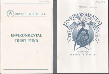 Bendigo Historical Society Inc.
Booklet - Kangaroo Flat Gold Mine Collection: Environmental Trust Fund Policy booklet
The Bendigo Environmental Trust was established in 1995 with funds provided by Bendigo Mining NL. The Trust was administered by an honorary Board of Trustees. Preference was given to projects that reflected the philosophy of the Bendigo Region Conservation Strategy, namely flora and fauna, energy conservation, land and water protection and waste management. Two copies of an eight page booklet titled ' Environmental Trust Fund, sponsored by Bendigo Mining NL. One booklet date stamped 4 Sep 2002. Content identical in both: policy; how the Bendigo ining Environmental Trust works; who can apply; areas supported; how to apply; preferred format; limitations of grants; support period; when to apply, where to apply and project documentation required.Date stamp September 2005 on one copy.bendigo mining nl, environment, environmental trust, flora and fauna, energy conservation, waste management, land and water protection, kangaroo flat, goldmining -
 Melbourne Tram Museum
Document - Report, Tramway Board, "Valuation etc of Melbourne Tramway & Omnibus Co's freehold properties", c1917
Set of two valuations of the Car Houses or depots owned by MTO Co. titled "Valuation etc of Melbourne Tramway & Omnibus Co's freehold properties". Details the location, book value, municipal valuation, J Buchans & Co land separated for land and buildings and the company claims. One sheet on double foolscap, typed carbon copy and the other on a foolscap sheet with out the company's claim amount. Has a note regarding the company's head office in Bourke St and the Victoria St Feed Works. Two copies held.trams, tramways, mto co, winding houses, depot, cable trams, property, horse trams, head office -
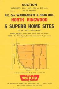 Ringwood and District Historical Society
Flyer, Land Auction, Cnr Warrandyte and Oban Roads, North Ringwood, Vic. - 1974
Single yellow page advertising Auction of five home sites to be sold separately on Saturday, 11th May, 1974. Details include vendor terms, subdivision services, and location map (north-east corner of Warrandyte and Oban Roads).(Agent) Eric Weber & Co. Pty. Ltd., 148 Wellington Parade, East Melbourne, 3002, Phone: 416025, Mr Elliott A.H. 8577502. Later handwritten notation suggests vendor was possibly Country Roads Board (VicRoads) after completion of road widening works. -
 Flagstaff Hill Maritime Museum and Village
Photograph - Historical, building, Late 19th to early 20th century
The black and white photograph depicts the Lady Bay Lighthouse Complex at Flagstaff Hill, Warrnambool. It was opened on this site in 1871. From left to right, the Chartroom (previously named the Store), Upper Lighthouse, Flagstaff, Lighthouse Keeper's Quarters. The bluestone buildings are facing North on Merri Street. The Harbour Pilot's Lodgings were on the east of the Complex. There are two unknown male figures standing in front of the light-coloured picket fence that encompasses the Complex. The photograph is mounted on card. WARRNAMBOOL'S LADY BAY LIGHTHOUSES In the 1800s ships sailing from England to Australia began to use Bass Strait as a faster route to Melbourne. Small navigation errors led to many tragic shipwrecks. From 1848 lighthouses were operating along Victoria’s southern coast as a guide for sailors. Coastal towns such as Warrnambool grew and the exchange of trade and passengers was of great benefit. However, the uncertain weather changes, relatively shallow waters and treacherous, hidden rocky reefs were not really suitable for a Harbour and in the 1840s and 1850s, there were many shipwrecks in the area, with some even stranded in its Lady Bay harbour. A jetty was built in 1850 and a flagstaff to guide seafarers was placed up high on what became known now as Flagstaff Hill. In November 1857 the Victorian Government recommended that Warrnambool Harbour had beacons and two lighthouses to guide vessels into and out of the Harbour safely. The white light of the Middle Island lighthouse was to be used for the first time on September 1, 1859. The red light of the Beach Lighthouse, a wooden obelisk structure, was first operated on March 25, 1860, but in 1868 this light was ‘discontinued’ due to it being too low. Melbourne’s Department of Public Works decided to relocate the Middle Island Lighthouse Complex - Lighthouse, Keeper’s Quarters, Privy, Store Room and even water tanks - to Flagstaff Hill. The lower obelisk was shortened, and a protruding gallery, railing, and external ladder were added, and the light from the Beach Lighthouse. A green guiding light was erected on the end of the jetty. The transfer of the Complex began in March 1871. Each shaped stone of the lighthouse was carefully numbered, removed then reassembled on Flagstaff Hill. In 1872 the well was sunk behind the Lighthouse Keeper’s Cottage. The Keepers and families had left Middle Island in April and moved to Flagstaff Hill in October 1871. Vessels entering Lady Bay align the Upper and Lower Lighthouse towers during the day and the lights at night. The Upper Lighthouse is a round tower, and the Lower Light is square. The Lighthouses were categorised as harbour lights rather than coastal lights, so they remain under the control of the Victorian Government’s Ports and Harbours section. The lights were originally powered by oil, then acetylene gas, later by electricity, and then converted to solar power in 1988. In 1993 the solar panel was replaced by a battery charger. A decision was made in 1936 to replace the lighthouses’ lights with unattended lights that no longer required Keepers and Assistants. At least 29 Keepers had attended to the lighthouse from its opening in 1859 to when the last official Lightkeepers left In April 1916. The Warrnambool Harbour Board rented out the Quarters from 1916 to 1936. The Board closed down but the rentals continued with other unknown landlords. In the 1970s the Flagstaff Hill Planning Board was set up under the chairmanship of John Lindsay. The Board was to make recommendations to the Warrnambool City Council regarding using the buildings and the rest of the Crown Land on the site. The Flagstaff Hill Maritime Village opened in 1975 and began renovating the Cottage in stages, during which time evidence of a 1920s fire was found in the eastern section of the cottage. Additions of a porch on the west and a washroom on the east were made in the 1980s. The western part of the building is now a Shipwreck Museum and the east has returned to a late 19th-century Lighthouse Keeper’s cottage and includes the screen made by Assistant Lighthouse Keeper Thomas Hope in the late 19th century. He served as Assistant Keeper in Warrnambool for two periods.The Warrnambool Lighthouse Complex is now listed on the Victorian Heritage Register, H1520, for being of historical, scientific (technological) and architectural significance to the State of Victoria. The Complex is significant as an example of early colonial development. The buildings are significant for their connection with the important navigational function of the Lighthouses, a function still being performed to this day. The buildings are also significant as an example of structures designed and works carried out by the Public Works Department in Victoria in the mid-to-late 19th century. The structures still stand strong. Photograph; Warrnambool Lighthouse Keeper's cottage, lighthouse, flagstaff and chartroom at Flagstaff Hill, and a light-coloured picket fence with gate. Two male figures are in front of the fence. Black and white print glued to a yellow card. The inscription is indecipherable. The right side of the cottage has a built-in, enclosed addition.Ink stamped in lower right hand corner, too faded to be legible.flagstaff hill, flagstaff hill maritime museum, flagstaff hill maritime village, warrnambool, maritime museum, shipwreck coast, lighthouse keeper's cottage, lighthouse residence, lighthouse, chart room, quarters, privy, middle island, beach lighthouse, obelisk, lighthouse complex, lady bay complex, warrnambool port, warrnambool harbour, lady bay, keepers, lighthouse keeper, upper lighthouse, lower lighthouse, assistant keeper, ports and harbours, cottage -
 Eltham District Historical Society Inc
Film - Video (DVD), Melbourne and Metropolitan Board of Works, Yarra River Conference Proceedings; a Board of Works centenary event, 13-16 April 1991
Yarra River Conference History Segment [Noted on VHS tape jackets "Due to unavoidable circumstances, the quality of these tapes in some setions is less than desired."] The Yarra River Conference, organised by the Board of Works as part of the Centenary Celebrations, was held in the Board's Head Office Theatrette from 13-16 April, 1991. A segment of the Conference focussed on the role that the Yarra River has played in relation to the historical development of Melbourne. Conceived and presented by a group of prominent historians as a chronological 'trip down the river in time', and profusely illustrated with slides, this segment traced the various impacts that urban and rural growth, development of marine commerce, recreational uses, and environmental problems have had on the Yarra during a century and a half of European occupation. As no formal written paper of this combined presentation is available, these two video-tapes provide a record for anyone who has an interest in tis fascinating aspect of the Yarra's history. The speakers who combined to present this segment are identified on the cover of Tape 2. Tape 1 (2 hours) 1838-1863 Deputy ?? to Utility Early navigators of the Yarra River; developing the port of Melbourne; the gold rush and its effect on the new colony; punts and bridges; water supply; pollution of the Yarra; the discovery of gold and early settlement of the Yarra valley; floods of 1839 and 1863. 1863-1891 Formation of the Harbour Trust; Coode Canal; pollution of the Yarra by industry; aborigines, gold miners, timber getters in the Upper Yarra areas; bridges; the flood of 1891. Tape 2 ( 1 1/2 hours) 1892-1934: People Begin to See Beauty and Romance to the River Henley-on-Yarra; realignment of the Yarra; MMBW is responsible for a sewerage system; new docks to cope with increased overseas trade; development of recreational parks; new reservoirs; timber production and timber tramways; bushfire; flood of 1934. 1935-1970: The River is Neglected Still, Except When it Proves Useful Bushfirs of 1939; the end of many sawmills; birth of tourism; increased interest in conservation and preservation of land for open space; further augmentation of water supply system; birth of containerisation changes the port; environmental concerns gain momentum. Speakers Dr Tony Dingle *, Department of Economic History, Monash University Dr Carolyn Rasmussen *, History Consultant Prof. Graeme Davison, History Department, Monash University Mr. Tom Griffiths, Lecturer in Public History, Monash Uiversity Mr. Patrick Miller, History Consultant Mr. Colin Jones, Author and Historian * Co-authors of the Board's history, 'Vital Connections'.video recording, yarra river, conference proceedings