Showing 2038 items
matching building plan
-
 Federation University Historical Collection
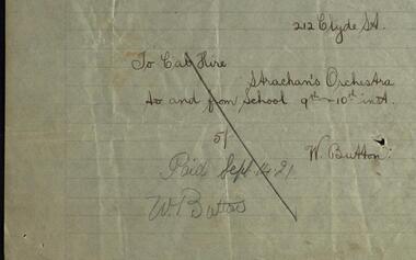
Hand written document, Ballarat Junior Technical School Correspondence 1921, 1921
... building was needed. Plans were drawn and a school built within... at the Dana Street State School. As numbers grew a larger building ...Ballarat Junior Technical School opened in 1913. It was located at the Dana Street State School. As numbers grew a larger building was needed. Plans were drawn and a school built within the grounds of the School of Mines. Students started at this new school in 1921. It was officially opened on 9 September 1921 by Sir Alexander, resident of Creswick, local member for North Ballarat and the Minister for Education. He also opened the School Fair which coincided with the buildings ceremony. This was a fair on a grand scale and lasted two days and nights. Staff and students worked for weeks making articles for sale. A parent's committee led by Mr J Rogerson, a local police detective, had been organizing for months. As part of the ceremony for the opening of the school the Strachan Orchestra was engaged to play. .1 Taxi hire provided transport for the Strachan Orchestra for two visits at a total cost of Five Shillings. This hand written slip shows the date of payment and by whom .2 This item is the receipt N A Strachan sent to Mr Steane, Headmaster of the school, for the payment of Two Pounds, cost for engaging the Orchestra. Money raised funded the dodge-ball court, purchased a typewriter, a second-hand piano, an inter-room telephone system, an epidiascope and film projector.Hand written notes on lined paper. .1 Invoice; .2 Receipt.1 Signature of W. Button .2 Signature of N.A. Strachan.ballarat junior technical school, dana street, ballarat school of mines, minister for education, member for north ballarat, school fair, strachan orchestra, receipt, albert steane, ceremony, taxi, typewriter, piano, telephone system, payment notice, sir alexander peacock -
 Bendigo Historical Society Inc.
Document - JOAN LEVERSHA COLLECTION: HOUSE PLANS 12 BOLT STREET, LONG GULLY
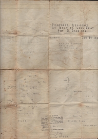
... Various documents relating to the plan building of house... building of house at 12 Bolt Street, Long Gully. 1)Plan of proposed ...Various documents relating to the plan building of house at 12 Bolt Street, Long Gully. 1)Plan of proposed residence at Bolt Street, Long Gully for D. Dean Esq. job No. 133R plan drawn by A.S. and R.A. Eggleston Architects, 186 Mitchell Street, Bendigo. Stamp of the City of Bendigo approving the plan, signed by an official and dated 27/07/1950. 2) inside plan drawn in pencil and blue Biro, stamped by City of Bendigo and Bendigo Sewerage Authority. 3) Another drawing of section done in blue Biro. 4) Application for permit to construct No.4746. 5) Two pages on A4 paper written in blue pen, under the title City of Bendigo information for builders in regard to weatherboard buildings, long list of regulations to be followed, stamp of City of Bendigo and signature of D. Dean dated 27/07/1950. 6) small paper with various dimensions. All this documents are in a paper envelope marked Doug, house, 12 Bolt St.house, private, drawings -
 Kew Historical Society Inc
Plan, Melbourne & Metropolitan Board of Works : Borough of Kew : Detail Plan No.1590, 1905
... Original survey plan, issued by the MMBW to a contractor... The Melbourne and Metropolitan Board of Works (MMBW) plans were produced ...The Melbourne and Metropolitan Board of Works (MMBW) plans were produced from the 1890s to the 1950s. They were crucial to the design and development of Melbourne's sewerage and drainage system. The plans, at a scale of 40 feet to 1 inch (1:480), provide a detailed historical record of Melbourne streetscapes and environmental features. Each plan covers one or two street blocks (roughly six streets), showing details of buildings, including garden layouts and ownership boundaries, and features such as laneways, drains, bridges, parks, municipal boundaries and other prominent landmarks as they existed at the time each plan was produced. (Source: State Library of Victoria)This plan forms part of a large group of MMBW plans and maps that was donated to the Society by the Mr Poulter, City Engineer of the City of Kew in 1989. Within this collection, thirty-five hand-coloured plans, backed with linen, are of statewide significance as they include annotations that provide details of construction materials used in buildings in the first decade of the 20th century as well as additional information about land ownership and usage. The copies in the Public Record Office Victoria and the State Library of Victoria are monochrome versions which do not denote building materials so that the maps in this collection are invaluable and unique tools for researchers and heritage consultants. A number of the plans are not held in the collection of the State Library of Victoria so they have the additional attribute of rarity.Original survey plan, issued by the MMBW to a contractor with responsibility for constructing sewers in the area identified on the plan within the Borough of Kew. The plan was at some stage hand-coloured, possibly by the contractor, but more likely by officers working in the Engineering Department of the Borough and later Town, then City of Kew. The hand-coloured sections of buildings on the plan were used to denote masonry or brick constructions (pink), weatherboard constructions (yellow), and public buildings (grey). Surveyed by the Board of Works in 1903 and published in 1904, Plan No.1590 shows development north of Cotham Road. While this plan includes built structures in Mary Street, Cotham Road, High Street, Park Hill Road, Kent Street, Ridgeway Avenue, and Ermington Lane (now Ermington Place), only part of this section was notated and coloured in this contractor’s copy. Numerous houses, large and small are named on the plan: ‘Cholula’, ‘Belper’, ‘The Uplands’, ‘Spring Grove’ facing Cotham Road; ‘Marion’ facing Kent Street; and ‘Kia Ora’ facing Ridgeway Avenue.melbourne and metropolitan board of works, detail plans, mmbw 1590, survey plans - borough of kew, cartography -
 Bendigo Historical Society Inc.
Book - BOOKLET: REPORT TO RESIDENTS CITY OF GREATER BENDIGO, 1996
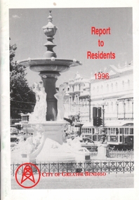
... and gardens; Planning and building; Waste management in Bendigo... and leisure; Parks and gardens; Planning and building; Waste ...Front cover is a photo of Alexandra Fountain. 52 paged booklet - ''Report to Residents - City of Greater Bendigo, 1995. Table of Contents; The Mayor; Chief Executive Officer; Council meetings; Office location and hours; ''One Telephone Number''; Locations of functions and business; Units; Organisation Structure; Advisory Committee; Municipal Boundaries; Customer services; Economic development; Bendigo Tourism; Bendigo Trust; Events Bendigo; Capital works 1996/97; Bendigo Regional Arts Centre; Local laws; Aged and disability services; Children and family services; Environmental health; Recreation and leisure; Parks and gardens; Planning and building; Waste management in Bendigo; Library services; Rates; Budget for 1996/97; The budget at a glance; Index.bendigo, council, report -
 Bendigo Historical Society Inc.
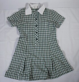
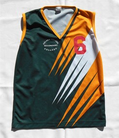
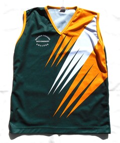
Uniform - GSSC School Uniform
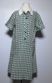
... of the Bendigo Education Plan. Its buildings were demolished. (Wikipedia... Education Plan. Its buildings were demolished. (Wikipedia https ...Golden Square High School in the city of Bendigo, was established in temporary accommodation at Camp Hill Primary School in central Bendigo in 1960. With the completion of the new school's buildings, it moved to Golden Square in 1962, providing for Forms 1 to 6, now known as years 7 to 12. In 1978 it became a 7–10 school and was one of the original feeder schools to Bendigo Senior High School. In 1986, a Hearing Impaired Unit was established and in 1990 it underwent a name change to become Golden Square Secondary College. The Golden Square Secondary College campus closed on 28 November 2008. It merged with Kangaroo Flat and Flora Hill secondary colleges as part of the implementation of the Bendigo Education Plan. Its buildings were demolished. (Wikipedia https://en.wikipedia.org/wiki/Golden_Square_Secondary_College) This uniform collection belonged to Anna Matthews, daughter of the donor, who attended GSSC as part of the last group enrolled before the school closed in 2008. Golden Square Secondary College school uniform including a dress, skirt, jumper, rugby tops, windcheater, jacket, sports tops and a tie. All items are in the school colours of green, white and gold.gssc, golden square secondary college, uniform, bendigo education plan. -
 Bendigo Historical Society Inc.
Uniform - GSSC School Dress
... of the Bendigo Education Plan. Its buildings were demolished. (Wikipedia... Education Plan. Its buildings were demolished. (Wikipedia https ...Golden Square High School in the city of Bendigo, was established in temporary accommodation at Camp Hill Primary School in central Bendigo in 1960. With the completion of the new school's buildings, it moved to Golden Square in 1962, providing for Forms 1 to 6, now known as years 7 to 12. In 1978 it became a 7–10 school and was one of the original feeder schools to Bendigo Senior High School. In 1986, a Hearing Impaired Unit was established and in 1990 it underwent a name change to become Golden Square Secondary College. The Golden Square Secondary College campus closed on 28 November 2008. It merged with Kangaroo Flat and Flora Hill secondary colleges as part of the implementation of the Bendigo Education Plan. Its buildings were demolished. (Wikipedia https://en.wikipedia.org/wiki/Golden_Square_Secondary_College) This uniform collection belonged to Anna Matthews, daughter of the donor, who attended GSSC as part of the last group enrolled before the school closed in 2008. Golden Square Secondary College school dress made from green and white cotton and polyester check fabric. There is a thin yellow line at edges of check pattern. Short set in sleeves with a cuff edged with piping. White flat collar. The dress has a front placket opening to the waist fastened with four dark green buttons. Bust darts on both sides. Front and back below the waist have two inverted pleats. On the right hand side there is an internal pocket with a zip fastener. At centre back is a decorative half belt with diagonal check. Machine hemmed.Tag below collar. Front. "PREFECT Value Based Apparel. NAME _ _ _ _ _ _ _ " Reverse "65% Polyester 35% Cotton. Washing Instructions."gssc, golden square secondary college, uniform, bendigo education plan., school dress -
 Bendigo Historical Society Inc.
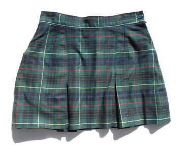
Uniform - GSSC School Skirt
... of the Bendigo Education Plan. Its buildings were demolished. (Wikipedia... Education Plan. Its buildings were demolished. (Wikipedia https ...Golden Square High School in the city of Bendigo, was established in temporary accommodation at Camp Hill Primary School in central Bendigo in 1960. With the completion of the new school's buildings, it moved to Golden Square in 1962, providing for Forms 1 to 6, now known as years 7 to 12. In 1978 it became a 7–10 school and was one of the original feeder schools to Bendigo Senior High School. In 1986, a Hearing Impaired Unit was established and in 1990 it underwent a name change to become Golden Square Secondary College. The Golden Square Secondary College campus closed on 28 November 2008. It merged with Kangaroo Flat and Flora Hill secondary colleges as part of the implementation of the Bendigo Education Plan. Its buildings were demolished. (Wikipedia https://en.wikipedia.org/wiki/Golden_Square_Secondary_College) This uniform collection belonged to Anna Matthews, daughter of the donor, who attended GSSC as part of the last group enrolled before the school closed in 2008. Golden Square Secondary College girl's school skirt. Dark green, mid green, yellow and red tartan. Expandable waist band across the back of the waistband. Internal pocket below front waistband. Side opening zip and button fasteners. Two inverted box pleats on the front and the back.gssc, golden square secondary college, uniform, bendigo education plan., skirt -
 Bendigo Historical Society Inc.
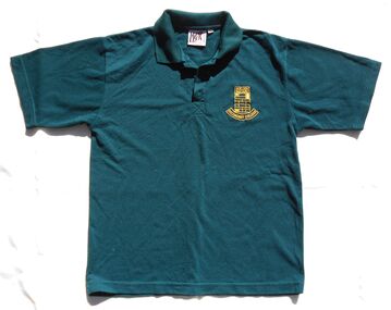
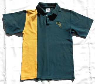
Uniform - GSSC School polo shirt
... of the Bendigo Education Plan. Its buildings were demolished. (Wikipedia... Education Plan. Its buildings were demolished. (Wikipedia https ...Golden Square High School in the city of Bendigo, was established in temporary accommodation at Camp Hill Primary School in central Bendigo in 1960. With the completion of the new school's buildings, it moved to Golden Square in 1962, providing for Forms 1 to 6, now known as years 7 to 12. In 1978 it became a 7–10 school and was one of the original feeder schools to Bendigo Senior High School. In 1986, a Hearing Impaired Unit was established and in 1990 it underwent a name change to become Golden Square Secondary College. The Golden Square Secondary College campus closed on 28 November 2008. It merged with Kangaroo Flat and Flora Hill secondary colleges as part of the implementation of the Bendigo Education Plan. Its buildings were demolished. (Wikipedia https://en.wikipedia.org/wiki/Golden_Square_Secondary_College) This uniform collection belonged to Anna Matthews, daughter of the donor, who attended GSSC as part of the last group enrolled before the school closed in 2008. Golden Square Secondary College girl's dark green short sleeved polo shirt. Yellow embroidered school logo on left hand side.Tag below collar " MASK Melbourne Polyester/Cotton Made in China Size 14" "Washing Instructions on reverse."gssc, golden square secondary college, uniform, bendigo education plan., polo shirt -
 Bendigo Historical Society Inc.
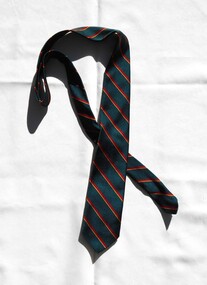
Uniform - GSSC School Tie
... of the Bendigo Education Plan. Its buildings were demolished. (Wikipedia... Education Plan. Its buildings were demolished. (Wikipedia https ...Golden Square High School in the city of Bendigo, was established in temporary accommodation at Camp Hill Primary School in central Bendigo in 1960. With the completion of the new school's buildings, it moved to Golden Square in 1962, providing for Forms 1 to 6, now known as years 7 to 12. In 1978 it became a 7–10 school and was one of the original feeder schools to Bendigo Senior High School. In 1986, a Hearing Impaired Unit was established and in 1990 it underwent a name change to become Golden Square Secondary College. The Golden Square Secondary College campus closed on 28 November 2008. It merged with Kangaroo Flat and Flora Hill secondary colleges as part of the implementation of the Bendigo Education Plan. Its buildings were demolished. (Wikipedia https://en.wikipedia.org/wiki/Golden_Square_Secondary_College) This uniform collection belonged to Anna Matthews, daughter of the donor, who attended GSSC as part of the last group enrolled before the school closed in 2008. Golden Square Secondary College school tie. Dark green with diagonal red and yellow stripes.gssc, golden square secondary college, uniform, bendigo education plan., tie -
 Bendigo Historical Society Inc.
Uniform - GSSC School Jacket
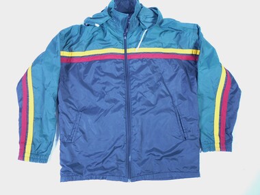
... of the Bendigo Education Plan. Its buildings were demolished. (Wikipedia... Education Plan. Its buildings were demolished. (Wikipedia https ...Golden Square High School in the city of Bendigo, was established in temporary accommodation at Camp Hill Primary School in central Bendigo in 1960. With the completion of the new school's buildings, it moved to Golden Square in 1962, providing for Forms 1 to 6, now known as years 7 to 12. In 1978 it became a 7–10 school and was one of the original feeder schools to Bendigo Senior High School. In 1986, a Hearing Impaired Unit was established and in 1990 it underwent a name change to become Golden Square Secondary College. The Golden Square Secondary College campus closed on 28 November 2008. It merged with Kangaroo Flat and Flora Hill secondary colleges as part of the implementation of the Bendigo Education Plan. Its buildings were demolished. (Wikipedia https://en.wikipedia.org/wiki/Golden_Square_Secondary_College) This uniform collection belonged to Anna Matthews, daughter of the donor, who attended GSSC as part of the last group enrolled before the school closed in 2008. Golden Square Secondary College navy waterproof jacket. Yoke extends across front and both sleeves with yellow and red stripes extending across both sleeves front and back. Hooded with white drawstring. Hood may be rolled and enclosed in zippered casing. Flannelette lined. Full length zippered front opening. internal side pockets with placket edges. Tag " KEA 14k" Phone 03 9796 3766"gssc, golden square secondary college, uniform, bendigo education plan., waterproof jacket -
 Bendigo Historical Society Inc.
Uniform - GSSC School Jumper
... of the Bendigo Education Plan. Its buildings were demolished. (Wikipedia... Education Plan. Its buildings were demolished. (Wikipedia https ...Golden Square High School in the city of Bendigo, was established in temporary accommodation at Camp Hill Primary School in central Bendigo in 1960. With the completion of the new school's buildings, it moved to Golden Square in 1962, providing for Forms 1 to 6, now known as years 7 to 12. In 1978 it became a 7–10 school and was one of the original feeder schools to Bendigo Senior High School. In 1986, a Hearing Impaired Unit was established and in 1990 it underwent a name change to become Golden Square Secondary College. The Golden Square Secondary College campus closed on 28 November 2008. It merged with Kangaroo Flat and Flora Hill secondary colleges as part of the implementation of the Bendigo Education Plan. Its buildings were demolished. (Wikipedia https://en.wikipedia.org/wiki/Golden_Square_Secondary_College) This uniform collection belonged to Anna Matthews, daughter of the donor, who attended GSSC as part of the last group enrolled before the school closed in 2008. Golden Square Secondary College dark green school jumper with V neck and raglan sleeves. GSSC red, green, yellow and white logo on LHS."DUX by DOBSONS" "Ph. 03 9819 1122" "Size 14" Reverse tag "80 % Wool 20 % Nylon. Washing instructions.gssc, golden square secondary college, uniform, bendigo education plan., jumper -
 Bendigo Historical Society Inc.
Uniform - GSSC School Windcheater
... of the Bendigo Education Plan. Its buildings were demolished. (Wikipedia... Education Plan. Its buildings were demolished. (Wikipedia https ...Golden Square High School in the city of Bendigo, was established in temporary accommodation at Camp Hill Primary School in central Bendigo in 1960. With the completion of the new school's buildings, it moved to Golden Square in 1962, providing for Forms 1 to 6, now known as years 7 to 12. In 1978 it became a 7–10 school and was one of the original feeder schools to Bendigo Senior High School. In 1986, a Hearing Impaired Unit was established and in 1990 it underwent a name change to become Golden Square Secondary College. The Golden Square Secondary College campus closed on 28 November 2008. It merged with Kangaroo Flat and Flora Hill secondary colleges as part of the implementation of the Bendigo Education Plan. Its buildings were demolished. (Wikipedia https://en.wikipedia.org/wiki/Golden_Square_Secondary_College) This uniform collection belonged to Anna Matthews, daughter of the donor, who attended GSSC as part of the last group enrolled before the school closed in 2008. Golden Square Secondary College dark green fleece school windcheater with yoke and set in sleeves. Half zip at centre front. Two internal side pockets with zip openings. Collar lined with red fabric. Size 12. GSSC red, green, yellow and white logo on LHS."DUX by DOBSONS" "Ph. 03 9819 1122" "Name Anna Matthews".gssc, golden square secondary college, uniform, bendigo education plan., windcheater -
 Bendigo Historical Society Inc.
Uniform - GSSC School Rugby Top
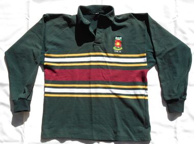
... of the Bendigo Education Plan. Its buildings were demolished. (Wikipedia... Education Plan. Its buildings were demolished. (Wikipedia https ...Golden Square High School in the city of Bendigo, was established in temporary accommodation at Camp Hill Primary School in central Bendigo in 1960. With the completion of the new school's buildings, it moved to Golden Square in 1962, providing for Forms 1 to 6, now known as years 7 to 12. In 1978 it became a 7–10 school and was one of the original feeder schools to Bendigo Senior High School. In 1986, a Hearing Impaired Unit was established and in 1990 it underwent a name change to become Golden Square Secondary College. The Golden Square Secondary College campus closed on 28 November 2008. It merged with Kangaroo Flat and Flora Hill secondary colleges as part of the implementation of the Bendigo Education Plan. Its buildings were demolished. (Wikipedia https://en.wikipedia.org/wiki/Golden_Square_Secondary_College) This uniform collection belonged to Anna Matthews, daughter of the donor, who attended GSSC as part of the last group enrolled before the school closed in 2008. Golden Square Secondary College long sleeved dark green rugby top. Ribbed knit fabric with ribbed cuffs on sleeves. Two white buttons. Cotton reinforcing band inside collar. Size 40. 11 cm band of red, yellow and white stripes across the body back and front. GSSC Year 10 logo on LHS."BOATMAN" Washing instructions on reverse.gssc, golden square secondary college, uniform, bendigo education plan., rugby top -
 Bendigo Historical Society Inc.
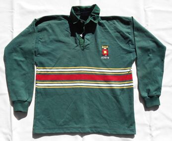
Uniform - GSSC School Rugby Top
... of the Bendigo Education Plan. Its buildings were demolished. (Wikipedia... Education Plan. Its buildings were demolished. (Wikipedia https ...Golden Square High School in the city of Bendigo, was established in temporary accommodation at Camp Hill Primary School in central Bendigo in 1960. With the completion of the new school's buildings, it moved to Golden Square in 1962, providing for Forms 1 to 6, now known as years 7 to 12. In 1978 it became a 7–10 school and was one of the original feeder schools to Bendigo Senior High School. In 1986, a Hearing Impaired Unit was established and in 1990 it underwent a name change to become Golden Square Secondary College. The Golden Square Secondary College campus closed on 28 November 2008. It merged with Kangaroo Flat and Flora Hill secondary colleges as part of the implementation of the Bendigo Education Plan. Its buildings were demolished. (Wikipedia https://en.wikipedia.org/wiki/Golden_Square_Secondary_College) This uniform collection belonged to Anna Matthews, daughter of the donor, who attended GSSC as part of the last group enrolled before the school closed in 2008. Golden Square Secondary College long sleeved dark green rugby top. Set in long sleeves. Fold over collar. Ribbed knit fabric with ribbed cuffs on sleeves. 22 cm band of yellow, white and red stripes across the body back and front. GSSC Year 10 logo on LHS.gssc, golden square secondary college, uniform, bendigo education plan., rugby top -
 Bendigo Historical Society Inc.
Uniform - GSSC School Sports Top
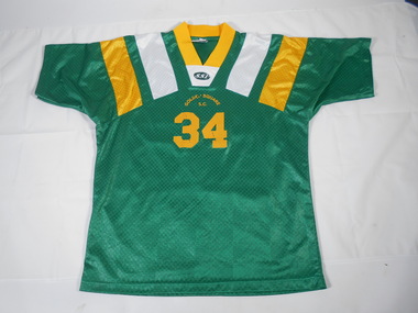
... of the Bendigo Education Plan. Its buildings were demolished. (Wikipedia... Education Plan. Its buildings were demolished. (Wikipedia https ...Golden Square High School in the city of Bendigo, was established in temporary accommodation at Camp Hill Primary School in central Bendigo in 1960. With the completion of the new school's buildings, it moved to Golden Square in 1962, providing for Forms 1 to 6, now known as years 7 to 12. In 1978 it became a 7–10 school and was one of the original feeder schools to Bendigo Senior High School. In 1986, a Hearing Impaired Unit was established and in 1990 it underwent a name change to become Golden Square Secondary College. The Golden Square Secondary College campus closed on 28 November 2008. It merged with Kangaroo Flat and Flora Hill secondary colleges as part of the implementation of the Bendigo Education Plan. Its buildings were demolished. (Wikipedia https://en.wikipedia.org/wiki/Golden_Square_Secondary_College) This uniform collection belonged to Anna Matthews, daughter of the donor, who attended GSSC as part of the last group enrolled before the school closed in 2008. Golden Square Secondary College dark green short sleeved sport top / soccer strip with with extended yoke section. V neck with yellow ribbed band. White and yellow vertical stripes on either side. Fabric has self patterned geometric pattern. Iron on letters "Golden Square SC" and numbers "34" (10 cm high) at centre front. Iron on "34" (20 cm high) centre back.White tag. "100% Polyester" "SSI" "MADE IN THAILAND"gssc, golden square secondary college, uniform, bendigo education plan., sports top -
 Bendigo Historical Society Inc.
Uniform - GSSC School Sports Singlet
... of the Bendigo Education Plan. Its buildings were demolished. (Wikipedia... Education Plan. Its buildings were demolished. (Wikipedia https ...Golden Square High School in the city of Bendigo, was established in temporary accommodation at Camp Hill Primary School in central Bendigo in 1960. With the completion of the new school's buildings, it moved to Golden Square in 1962, providing for Forms 1 to 6, now known as years 7 to 12. In 1978 it became a 7–10 school and was one of the original feeder schools to Bendigo Senior High School. In 1986, a Hearing Impaired Unit was established and in 1990 it underwent a name change to become Golden Square Secondary College. The Golden Square Secondary College campus closed on 28 November 2008. It merged with Kangaroo Flat and Flora Hill secondary colleges as part of the implementation of the Bendigo Education Plan. Its buildings were demolished. (Wikipedia https://en.wikipedia.org/wiki/Golden_Square_Secondary_College) This uniform collection belonged to Anna Matthews, daughter of the donor, who attended GSSC as part of the last group enrolled before the school closed in 2008. Golden Square Secondary College dark green sport singlet with with V neck and arm holes with yellow trim. LHS of singlet has tapering diagonal geometric white and yellow stripes. Fabric has self patterned geometric pattern. Size 16. White embroidered letters "Golden Square Secondary College" on RHS and red iron on "6" (10 cm) on LHS. Iron on "6" (20 cm) centre back.White tag 1." SPORTS SERVICE 2 WALKER STREET BRAESIDE VICTORIA 3195 03 9580 3511 MADE IN AUSTRAKIA" Tag 2 "Polyester" Washing instructions.gssc, golden square secondary college, uniform, bendigo education plan., sports singlet -
 Bendigo Historical Society Inc.
Uniform - GSSC School Sports Singlet
... of the Bendigo Education Plan. Its buildings were demolished. (Wikipedia... Education Plan. Its buildings were demolished. (Wikipedia https ...Golden Square High School in the city of Bendigo, was established in temporary accommodation at Camp Hill Primary School in central Bendigo in 1960. With the completion of the new school's buildings, it moved to Golden Square in 1962, providing for Forms 1 to 6, now known as years 7 to 12. In 1978 it became a 7–10 school and was one of the original feeder schools to Bendigo Senior High School. In 1986, a Hearing Impaired Unit was established and in 1990 it underwent a name change to become Golden Square Secondary College. The Golden Square Secondary College campus closed on 28 November 2008. It merged with Kangaroo Flat and Flora Hill secondary colleges as part of the implementation of the Bendigo Education Plan. Its buildings were demolished. (Wikipedia https://en.wikipedia.org/wiki/Golden_Square_Secondary_College) This uniform collection belonged to Anna Matthews, daughter of the donor, who attended GSSC as part of the last group enrolled before the school closed in 2008. Golden Square Secondary College dark green sport singlet with with V neck and arm holes with yellow trim. LHS of singlet has tapering diagonal geometric white and yellow stripes. Fabric has self patterned geometric pattern. Size 20. White embroidered letters "Golden Square Secondary College" on RHS.White tag 1." SPORTS SERVICE 21a VIKING COURT CHETENHAM VICTORIA 3192 03 9553 7053 MADE IN AUSTRAKIA" Tag 2 "Polyester" Washing instructions.gssc, golden square secondary college, uniform, bendigo education plan., sports singlet -
 Bendigo Historical Society Inc.
Uniform - GSSC School polo shirt
... of the Bendigo Education Plan. Its buildings were demolished. (Wikipedia... of the Bendigo Education Plan. Its buildings were demolished. (Wikipedia ...Golden Square High School in the city of Bendigo, was established in temporary accommodation at Camp Hill Primary School in central Bendigo in 1960. With the completion of the new school's buildings, it moved to Golden Square in 1962, providing for Forms 1 to 6, now known as years 7 to 12. In 1978 it became a 7–10 school and was one of the original feeder schools to Bendigo Senior High School. In 1986, a Hearing Impaired Unit was established and in 1990 it underwent a name change to become Golden Square Secondary College. The Golden Square Secondary College campus closed on 28 November 2008. It merged with Kangaroo Flat and Flora Hill secondary colleges as part of the implementation of the Bendigo Education Plan. Its buildings were demolished. (Wikipedia https://en.wikipedia.org/wiki/Golden_Square_Secondary_College) This uniform collection belonged to Anna Matthews, daughter of the donor, who attended GSSC as part of the last group enrolled before the school closed in 2008. Golden Square Secondary College girl's dark green short sleeved polo shirt with 12.5 cm yellow panel on RHS of front from shoulder to hem. Yellow embroidered intertwining letters GSSC on left hand side. Size 12.Tag below collar "DUX BY DOBSONS Phone 03 9619 1122" "NAME _ _ _ _ _ _ _ _ _ " "Washing Instructions on reverse."gssc, golden square secondary college, uniform, bendigo education plan., polo shirt -
 Bendigo Historical Society Inc.
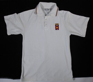
Uniform - GSSC School polo shirt
... of the Bendigo Education Plan. Its buildings were demolished. (Wikipedia... of the Bendigo Education Plan. Its buildings were demolished. (Wikipedia ...Golden Square High School in the city of Bendigo, was established in temporary accommodation at Camp Hill Primary School in central Bendigo in 1960. With the completion of the new school's buildings, it moved to Golden Square in 1962, providing for Forms 1 to 6, now known as years 7 to 12. In 1978 it became a 7–10 school and was one of the original feeder schools to Bendigo Senior High School. In 1986, a Hearing Impaired Unit was established and in 1990 it underwent a name change to become Golden Square Secondary College. The Golden Square Secondary College campus closed on 28 November 2008. It merged with Kangaroo Flat and Flora Hill secondary colleges as part of the implementation of the Bendigo Education Plan. Its buildings were demolished. (Wikipedia https://en.wikipedia.org/wiki/Golden_Square_Secondary_College) This uniform collection belonged to Anna Matthews, daughter of the donor, who attended GSSC as part of the last group enrolled before the school closed in 2008. Golden Square Secondary College girl's white short sleeved polo shirt. Red, yellow and dark green stripes on the collar. White buttons. Appliqued embroidered school logo on left hand side. Size 12.Tag below collar "DUX BY DOBSONS Phone 03 9619 1122" "NAME _ _ _ _ _ _ _ _ _ " "Washing Instructions on reverse."gssc, golden square secondary college, uniform, bendigo education plan., polo shirt -
 Bendigo Historical Society Inc.
Album - Tui Mitchell Collection: Album of Photographs, William Victor Mitchell "History of Architecture", 1990s
... plans of buildings designed by William V Mitchell. Each... by thirty five photographs and two floor plans of buildings designed ..."Greystanes" was originally "Hunter House" built at 57 Queen Street, Bendigo by Robert Hunter in 1882. Robert's brother William and his family lived there for almost 60 years. In 1945 the house was sold to Rex Hyett who renamed the house "Greystanes". Re removed the original verandah and balcony and built the portico. There were several other owners before it was purchased by the Country Roads Board/ VicRoads where it was the local office for 36 years years (1958 - 1994). From the late 1990s "Graystanes" was restored by Bill and Tui Mitchell who operated it as accommodation, restaurant and reception rooms. New owners then who turned it into a boutique hotel and conference centre. The current owners purchased "Greystanes" in 1910. It was renamed "Hunter House" and after extensive restorations was converted into a family home and business .Brown leather covered professionally bound album containing photographs of Bendigo buildings designed by Bendigo architect William Victor Mitchell. Includes thirty black card pages with rice paper interleaves. The first page has a black and white photograph of Bill Mitchell. This is followed by thirty five photographs and two floor plans of buildings designed by William V Mitchell. Each photograph is double mounted on white and silver card. Name labels are included on each page on white card mounted on silver card. These are followed by nine pages listing 249 buildings, extensions. renovations and projects completed by William V Mitchell. The final page has a photograph of Bill Mitchell. tha album was produced by SB Libris Bookbinder & Stationer. Bound in Bendigo.Label insidetui mitchell collection, greystanes, hunter house, william hunter, robert hunter -
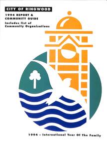 Ringwood and District Historical Society
Book, City of Ringwood, City of Ringwood 1994 Report & Community Guide, 1994
... Ringwood's Parks and Reserves 24 Building 25 Engineering Planning... and Gardens 23 Ringwood's Parks and Reserves 24 Building 25 ...The City of Ringwood and the City of Croydon merged in December 1994 and became the City of Maroondah.Community information book issued by City of Ringwood for 1994 - covering the facilities and activities of the Ringwood Council and other local organisations and associations. Includes Ringwood Public Golf Course discount vouchers and two Ringwood Aquatic Centre bonus entry vouchers.CONTENTS: (page no.) Contents A Message from the Mayor - Cr. Margaret Cheevers 3 Your Council 4 Local State and Federal MPs 5 Council Meetings and Elections 6 History of Ringwood 7 City Manager's Report 8 Organisational structure 9 Human Services 10-19 Environmental Health 20-21 Ringwood Library 22 Parks and Gardens 23 Ringwood's Parks and Reserves 24 Building 25 Engineering Planning Services 26-28 Waste Management 29 Town Planning 30 Traffic and Local Laws 31-33 Roads, Drainage and Major Works 38-39 Halls and Facilities 40-41 Aquatic Centre 42 Convention Centre/Karralika Theatre 43 Golf Course 44 Free Swim & Golf Discount Vouchers 45 Community Organisations 46-64 Finance 65-66 Administration 67 Community Liaison 68 Information Systems 69 Personnel 70-71 Risk Management 71 Rates and Valuations 72 rinx -
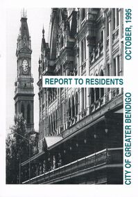 Bendigo Historical Society Inc.
Book - BOOKLET: ''REPORT TO RESIDENTS CITY OF GREATER BENDIGO, OCTOBER 1995''
... ; Parks and gardens; Planning and building; Waste management... and leisure; Parks and gardens; Planning and building; Waste ...Front cover is a photo of The Shamrock Hotel. 52 paged booklet - ''Report to Residents - City of Greater Bendigo, October 1995''. Table of Contents; Commissioners; Chief Executive Officer; Council meetings; Office location and hours; ''One Telephone Number''; Committees; Ward boundaries; Elections; Customer services; Rural services; Economic development; Bendigo Tourism Board; Bendigo Trust; Events Bendigo; Capital works 1995/96; Major projects; Discovery; Bendigo Regional Arts Centre; local laws; Fire prevention; Aged and disability services; Children and family services; Environmental health; Recreation and leisure; Parks and gardens; Planning and building; Waste management; Library services; Bendigo Leisureland; Rates; Budget for 1995/96; Index. Contains some photographs and map of proposed 7 internal Wards for the City of Greater Bendigo.Richard Cambridge Printers Bendigo.bendigo, council, report, maxine crouch, maurie sharkey, perer ross-edwards, peter seamer, hadley sides, richard morriss, bernard smith, annie galvin child care centre, bendigo regional art centre, rosalind park, budget 1995/96. bendigo health care services. -
 Kew Historical Society Inc
Plan, Melbourne & Metropolitan Board of Works / Borough of Kew, Detail Plan No.1593, 1905
... Original survey plan, issued by the MMBW to a contractor... The Melbourne and Metropolitan Board of Works (MMBW) plans were produced ...The Melbourne and Metropolitan Board of Works (MMBW) plans were produced from the 1890s to the 1950s. They were crucial to the design and development of Melbourne's sewerage and drainage system. The plans, at a scale of 40 feet to 1 inch (1:480), provide a detailed historical record of Melbourne streetscapes and environmental features. Each plan covers one or two street blocks (roughly six streets), showing details of buildings, including garden layouts and ownership boundaries, and features such as laneways, drains, bridges, parks, municipal boundaries and other prominent landmarks as they existed at the time each plan was produced. (Source: State Library of Victoria)This plan forms part of a large group of MMBW plans and maps that was donated to the Society by the Mr Poulter, City Engineer of the City of Kew in 1989. Within this collection, thirty-five hand-coloured plans, backed with linen, are of statewide significance as they include annotations that provide details of construction materials used in buildings in the first decade of the 20th century as well as additional information about land ownership and usage. The copies in the Public Record Office Victoria and the State Library of Victoria are monochrome versions which do not denote building materials so that the maps in this collection are invaluable and unique tools for researchers and heritage consultants. A number of the plans are not held in the collection of the State Library of Victoria so they have the additional attribute of rarity.Original survey plan, issued by the MMBW to a contractor with responsibility for constructing sewers in the area identified on the plan within the Borough of Kew. The plan was at some stage hand-coloured, possibly by the contractor, but more likely by officers working in the Engineering Department of the Borough and later Town, then City of Kew. The hand-coloured sections of buildings on the plan were used to denote masonry or brick constructions (pink), weatherboard constructions (yellow), and public buildings (grey). The laborious task of hand-tinting these Board of Works plans was not without hazards as is evidenced by Plan No. 1593. On the Plan, the original colourist spilt black and green ink, partially obscuring some parts. The most obvious casualty is ‘Clifton’ located on the corner of Cotham Road and Park Street [now Adeney Avenue]. Included in this Plan, and outlined in pink is that part of the section that the contracting engineer was tasked with completing. This included sewering on both sides of this part of Cotham Road, but excluded properties such as ‘Glendonald’ and ‘Monnington’. This area was to undergo a series of subdivisions including the ‘Clifton Estate’, which created housing lots on Adeney Avenue and Florence Avenue in 1916. The most notable occupant of Clifton was William Adeney [died 1893], a pioneer of Camperdown, after which Park Street was later renamed.melbourne and metropolitan board of works, detail plans, survey plans - borough of kew, mmbw 1593, cartography -
 Kew Historical Society Inc
Plan, Melbourne & Metropolitan Board of Works : Borough of Kew : Detail Plan No.1564, 1905
... Original survey plan, issued by the MMBW to a contractor... sections of buildings on the plan were used to denote masonry ...The Melbourne and Metropolitan Board of Works (MMBW) plans were produced from the 1890s to the 1950s. They were crucial to the design and development of Melbourne's sewerage and drainage system. The plans, at a scale of 40 feet to 1 inch (1:480), provide a detailed historical record of Melbourne streetscapes and environmental features. Each plan covers one or two street blocks (roughly six streets), showing details of buildings, including garden layouts and ownership boundaries, and features such as laneways, drains, bridges, parks, municipal boundaries and other prominent landmarks as they existed at the time each plan was produced. (Source: State Library of Victoria)This plan forms part of a large group of MMBW plans and maps that was donated to the Society by the Mr Poulter, City Engineer of the City of Kew in 1989. Within this collection, thirty-five hand-coloured plans, backed with linen, are of statewide significance as they include annotations that provide details of construction materials used in buildings in the first decade of the 20th century as well as additional information about land ownership and usage. The copies in the Public Record Office Victoria and the State Library of Victoria are monochrome versions which do not denote building materials so that the maps in this collection are invaluable and unique tools for researchers and heritage consultants. A number of the plans are not held in the collection of the State Library of Victoria so they have the additional attribute of rarity.Original survey plan, issued by the MMBW to a contractor with responsibility for constructing sewers in the area identified on the plan within the Borough of Kew. The plan was at some stage hand-coloured, possibly by the contractor, but more likely by officers working in the Engineering Department of the Borough and later Town, then City of Kew. The hand-coloured sections of buildings on the plan were used to denote masonry or brick constructions (pink), weatherboard constructions (yellow), and public buildings (grey). In 1905, when Plan No.1564 was printed, that part of Kew bordered by Brougham Place (now Daniell Place), Mount Street, Sackville Street and Ross Street was already the location of a number of large mansions. Here, subdivisions, at least at this stage, produced larger blocks than in Central Kew. Many of the houses on this plan are named: ‘Faybrook’, ‘Northumbria’, ‘Parkholm[e]’, ‘Dunboe’, ‘Katoomba’ and ‘Eschol’ fronting Sackville Street. Eschol was once the home of the manufacturer Robert Harrison, whose cordial factory in Spring and Argyle Streets Fitzroy are noted on the Victorian Heritage Register. ‘The Hawthorns’ on the corner of Brougham Place and Mount Street was the home of the medical practitioner Frank William Fay, who won the military cross and other honours for conspicuous gallantry and devotion to duty in World War 1.melbourne and metropolitan board of works, detail plans, mmbw 1564, cartography -
 Glen Eira Historical Society
Album - Album page, Kambrook Road, Circa 1972
... /planning-and-building/heritage/heritage-management-plan - re 9-11.../planning-and-building/heritage/heritage-management-plan - re 9-11 ...This photograph is part of the Caulfield Historical Album 1972. This album was created in approximately 1972 as part of a project by the Caulfield Historical Society to assist in identifying buildings worthy of preservation. The album is related to a Survey the Caulfield Historical Society developed in collaboration with the National Trust of Australia (Victoria) and Caulfield City Council to identify historic buildings within the City of Caulfield that warranted the protection of a National Trust Classification. Principal photographer thought to be Trevor Hart, member of Caulfield Historical Society. Most photographs were taken between 1966-1972 with a small number of photographs being older and from unknown sources. All photographs are black and white except where stated, with 386 photographs over 198 pages. https://vhd.heritagecouncil.vic.gov.au/places/43737 - re 26 Kambrook Road and 345 Balaclava Road corner building: A prominently situated two-storeyed complex of late Victorian buildings consisting of "Wybar's Buildings" occupying the Balaclava Road/ Kambrook Road corner and the "Caulfield Bakery" facing Kambrook Road, separated by a driveway from a single storeyed shop. The main building has a comer splay and balustraded parapet with curved pediments, the words "Wybar's Buildings 1887" having been obliterated but "Caulfield Bakery 1887" with the characteristic wheatsheaf surviving in raised cement work. The walls are stuccoed and richly ornamented with bracketed cornices and keystones with masks extending to the Bakery. The main building is further distinguished by the Masonic symbol of the mason's dividers in the pediment whilst the upper level of the bakery is in overpainted brickwork. The single storeyed shop incorporates the bracketed cornice and consoles characteristic of the main buildings and is in other respects a utilitarian structure. https://vhd.heritagecouncil.vic.gov.au/places/35413 - re 16 Kambrook Road A small late Victorian Italianate villa distinguished by its parapeted window bays either side of a small verandah with encaustic tiled floor. The parapets are balustraded with console enrichment and glazed tiles, the stuccoed surfaces being unpainted. Ornamentation is in other respects undistinguished. https://www.gleneira.vic.gov.au/services/planning-and-building/heritage/heritage-management-plan - re 9-11 Kambrook Road ... they demonstrate most of the commonly employed aesthetic devices characteristic of the Italianate Style including patterned brickwork, patterned slate roofs, cast iron lace verandahs, ornamental stucco work and ashlar boards...https://vhd.heritagecouncil.vic.gov.au/places/43737 - 345 Balaclava and 26 Kambrook Roads HO91 in City of Glen Eira "Wybar's Buildings" at the corner of Balaclava Road and Kambrook Road are important as a prominent late Victorian commercial development incorporating a variety of activities including a bakery and possibly a coffee palace, the latter understood to be unique within the municipality, but characteristic of the period. It is a rare complex of its type in Caulfield and is important also as evocative evidence of the late Victorian Land Boom and the creation of a small now defunct commercial centre at this location by the George Wybrow. https://vhd.heritagecouncil.vic.gov.au/places/35413 - 16 Kambrook Road HO121 in City of Glen Eira ''Hollywood'' at 16 Kambrook Road is of architectural interest for its pavilions which retain their unpainted parapets and ornamental tiles in the manner of other less imposing examples in the immediate locality possibly linked with the builder George Wybar and his son, who undertook substantial projects nearby. Its association with James Yorston, presumably is Yorston of Dickson and Yorston, important builders and estate developers at Caulfield during the Inter war period is of interest. https://www.gleneira.vic.gov.au/services/planning-and-building/heritage/heritage-management-plan - re 9-11 Kambrook Road HO152 Normanby Road/Kambrook Road, Caulfield North Statement of Significance: The Precinct is historically significant for its capacity to demonstrate standards of design and building construction in this part of the municipality during the late Land Boom years and especially just prior to the bank collapse of 1891. The housing stock is representative of the standards of amenity excepted by the middle classes of Melbourne society at the time, including artists, (horse) trainers, jockeys, managers, travellers, journalists and the like, also having a functional link with the activities of the Caulfield Racecourse which forms an important element in the history of the Municipality. The row of attached pairs at 5-11 Kambrook Road and 53-67 Kambrook Road is especially significant in this respect in that the narrow allotments are indicative of the owner/developer’s determination to maximise profits at the height of the Land Boom in 1891...Page 104 of Photograph Album with four photographs (landscape) of three different properties on Kambrook Road.Handwritten: Kambrook Road [top right] / WYBAR'S BUILDING 1887/ INC CAULFIELD BAKERY / [under top right photo] / 16 KAMBROOK ROAD / 1970 HIRST MRS J.N.[under bottom left photo] / 11-9 KAMBROOK ROAD / 1970 9-BUCKLAND MRS L.A / 11- ATKINS MRS N.E. [under bottom right photo] / 104 [bottom right]trevor hart, kambrook road, victorian, caulfield north, parapets, wybar's buildings 1887, caulfield bakery 1887, architectural features, painted bricks, balaclava road, victorian italianate style, houses, bay windows, verandahs, glazed tiles, shops, george wybar, builders, james yorston, dickson and yorston, j n hirst, l a buckland, n e atkins, patterned slate roofs, patterned bricks, cast iron work, attached houses -
 Kew Historical Society Inc
Plan, Melbourne & Metropolitan Board of Works : Borough of Kew : Detail Plan No.1296, 1904
... Original survey plan, issued by the MMBW to a contractor... sections of buildings on the plan were used to denote masonry ...The Melbourne and Metropolitan Board of Works (MMBW) plans were produced from the 1890s to the 1950s. They were crucial to the design and development of Melbourne's sewerage and drainage system. The plans, at a scale of 40 feet to 1 inch (1:480), provide a detailed historical record of Melbourne streetscapes and environmental features. Each plan covers one or two street blocks (roughly six streets), showing details of buildings, including garden layouts and ownership boundaries, and features such as laneways, drains, bridges, parks, municipal boundaries and other prominent landmarks as they existed at the time each plan was produced. (Source: State Library of Victoria)This plan forms part of a large group of MMBW plans and maps that was donated to the Society by the Mr Poulter, City Engineer of the City of Kew in 1989. Within this collection, thirty-five hand-coloured plans, backed with linen, are of statewide significance as they include annotations that provide details of construction materials used in buildings in the first decade of the 20th century as well as additional information about land ownership and usage. The copies in the Public Record Office Victoria and the State Library of Victoria are monochrome versions which do not denote building materials so that the maps in this collection are invaluable and unique tools for researchers and heritage consultants. A number of the plans are not held in the collection of the State Library of Victoria so they have the additional attribute of rarity.Original survey plan, issued by the MMBW to a contractor with responsibility for constructing sewers in the area identified on the plan within the Borough of Kew. The plan was at some stage hand-coloured, possibly by the contractor, but more likely by officers working in the Engineering Department of the Borough and later Town, then City of Kew. The hand-coloured sections of buildings on the plan were used to denote masonry or brick constructions (pink), weatherboard constructions (yellow), and public buildings (grey). This area was once known as O’Shaughnessy’s Paddock. O’Shaughnessy was the licensee of the Kew Hotel. The ‘Paddock’ or farm was for many years the closest farm to Melbourne. By 1903, when this plan was surveyed and lithographed, little of the farm remained. The area is dominated by a ‘clay hole’, on the site of the current Foley Reserve. It was used by Smart’s Brickyard from the 1880s until 1911, when the Council purchased it for a rubbish dump. It is notable as the site is one of the few industrial operations to have existed in Kew. By 1903, urban development was characterised by larger houses fronting Barkers Road and brick and weatherboard villas in Foley Street. Nearer the pit, weatherboard houses predominated. Foley Street bisected the triangular block and continued right to Denmark Street. At this stage, a house impeded the through road, only allowing access via a right of way to High Street.melbourne and metropolitan board of works, detail plans, mmbw 1296, cartography -
 Kew Historical Society Inc
Plan, Melbourne & Metropolitan Board of Works : Borough of Kew : Detail Plan No.1301, 1910
... Original survey plan, issued by the MMBW to a contractor... sections of buildings on the plan were used to denote masonry ...The Melbourne and Metropolitan Board of Works (MMBW) plans were produced from the 1890s to the 1950s. They were crucial to the design and development of Melbourne's sewerage and drainage system. The plans, at a scale of 40 feet to 1 inch (1:480), provide a detailed historical record of Melbourne streetscapes and environmental features. Each plan covers one or two street blocks (roughly six streets), showing details of buildings, including garden layouts and ownership boundaries, and features such as laneways, drains, bridges, parks, municipal boundaries and other prominent landmarks as they existed at the time each plan was produced. (Source: State Library of Victoria)This plan forms part of a large group of MMBW plans and maps that was donated to the Society by the Mr Poulter, City Engineer of the City of Kew in 1989. Within this collection, thirty-five hand-coloured plans, backed with linen, are of statewide significance as they include annotations that provide details of construction materials used in buildings in the first decade of the 20th century as well as additional information about land ownership and usage. The copies in the Public Record Office Victoria and the State Library of Victoria are monochrome versions which do not denote building materials so that the maps in this collection are invaluable and unique tools for researchers and heritage consultants. A number of the plans are not held in the collection of the State Library of Victoria so they have the additional attribute of rarity.Original survey plan, issued by the MMBW to a contractor with responsibility for constructing sewers in the area identified on the plan within the Borough of Kew. The plan was at some stage hand-coloured, possibly by the contractor, but more likely by officers working in the Engineering Department of the Borough and later Town, then City of Kew. The hand-coloured sections of buildings on the plan were used to denote masonry or brick constructions (pink), weatherboard constructions (yellow), and public buildings (grey). Throughout its history, the land in what is known today as Studley Ward of the City of Boroondara has been subject to continuing subdivision. This is evident in Plan 1301, where later hands have modified the original map to include streets created subsequent to the printing of the plan in 1904. Other annotations such as the ‘Reserved for Road Purposes’ beside the Yarra never eventuated. The plan continued to be modified to at least 1953, when a later hand noted that a particular site was ‘Property site P. McIntyre house’ in Swinton Avenue. Two significant houses in the area are outlined on the plan: ‘Swinton’ on the corner of the streets then named Effey and Maud Streets (now Swinton Avenue) and ‘Fairhaven’ [unnamed] in Stevenson Street. The gardens of the two David Syme owned mansions of ‘Blythswood’ and ‘Rockingham’, stretching down to the River Yarra, are also represented.melbourne and metropolitan board of works, detail plans, mmbw 1301, cartography -
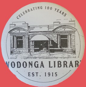 Wodonga & District Historical Society Inc
Badge - Wodonga Library 100 Years
... building and the plan was approved in June 1915 The building... and the plan was approved in June 1915 The building contractor was J. W ...W. Thorne architect of Albury designed the library building and the plan was approved in June 1915 The building contractor was J. W. Cochrane of Albury. The land was purchased from Mr. Walter Huon. On the 28th July 1915 the Shire President, Councillor Beardmore, laid the foundation stone for the building that would become the Wodonga Public Library. Almost 12 months later, on the 8th March 1916, the library was officially opened. It was the pride of Wodonga. The Shire Council closed their doors for a brief period so that all staff could attend the opening and the teachers and children of the local schools also attended. Councillor Beardmore declared that “it was an asset that would return a profit- not in pounds and shillings and pence but in the development and furnishing of the minds and lives of our young people”. It was known as the Beardmore Library. The Wodonga Athenaeum, in an out of the way location, had closed in 1914 after continuing reports of a lack of funds and the proceeds of the sale of the building went towards the building of the new library. In 1915 the library building committee started to put together a building fund for a new library. The library, situated at 78 High Street, was funded almost exclusively by the public. The books from the Athenaeum were presented to the library committee at the opening in 1916. The new library was both a place for education and recreation, a communal space to socialise, which also boasted a billiards room downstairs. In March 1970 construction of a new Civic Centre which included a library began in Wodonga. With its completion the following year, the original library was closed down. The building was vacant for some time and deteriorated badly. It was later purchased by Peter Middleton, who extensively restored the building. This badge is significant because it was produced to commemorate the centenary of an important Wodonga building.A metal and plastic badge featuring a sketch of the Wodonga Library as well as text.CELEBRATING 100 YEARS WODONGA LIBRARY EST. 1915wodonga library, wodonga buildings -
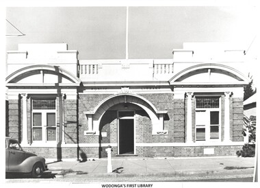 Wodonga & District Historical Society Inc
Photograph - Original Wodonga Library
... and the plan was approved in June 1915 The building contractor was J... and the plan was approved in June 1915 The building contractor was J. W ...W. Thorne architect of Albury designed the library building and the plan was approved in June 1915 The building contractor was J. W. Cochrane of Albury. The land was purchased from Mr. Walter Huon. On the 28th July 1915 the Shire President, Councillor Beardmore, laid the foundation stone for the building that would become the Wodonga Public Library. Almost 12 months later, on the 8th March 1916, the library was officially opened. It was the pride of Wodonga. The Shire Council closed their doors for a brief period so that all staff could attend the opening and the teachers and children of the local schools also attended. Councillor Beardmore declared that “it was an asset that would return a profit- not in pounds and shillings and pence but in the development and furnishing of the minds and lives of our young people”. It was known as the Beardmore Library. The Wodonga Athenaeum, in an out of the way location, had closed in 1914 after continuing reports of a lack of funds and the proceeds of the sale of the building went towards the building of the new library. In 1915 the library building committee started to put together a building fund for a new library. The library, situated at 78 High Street, was funded almost exclusively by the public. The books from the Athenaeum were presented to the library committee at the opening in 1916. The new library was both a place for education and recreation, a communal space to socialise, which also boasted a billiards room downstairs. In March 1970 construction of a new Civic Centre which included a library began in Wodonga. With its completion the following year, the original library was closed down. The building was vacant for some time and deteriorated badly. It was later purchased by Peter Middleton, who extensively restored the building. These images have local significance as they document an important building in Wodonga.2 photos - one black and white and one in colour of the same brick building. The first photo is of the building when it served as the Wodonga Public Library. The colour photo was taken approximately 60 years later.Photo 1 - In Brickwork above the door: PUBLIC LIBRARY Photo 2 - Above door: MIDDLETONS CARPETSwodonga public library, wodonga buildings -
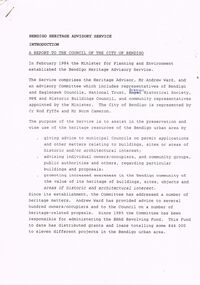 Bendigo Historical Society Inc.
Document - BENDIGO HERITAGE ADVISORY SERVICE: REPORT TO COUNCIL, JAN 1987
... to Planning Scheme; Policy encouraging reuse of Buildings; Adoption... to Planning Scheme; Policy encouraging reuse of Buildings; Adoption ...Bendigo Heritage Advisory Service - Report to Council, Jan 1987, This appears to be a draft report as there are handwritten changes on a number of pages. Report is set out in the form of an Introduction and a Summary. Advisory Service comprised Heritage Advisor, Andrew Ward; Bendigo and Eaglehawk Councils; National Trust; Bendigo Historical Society; MPE and Historic Buildings Council; community representatives??; City of Bendigo - Cr Rod Fyffe, Mr Norm Cameron. Recommendations - Changes to Planning Scheme; Policy encouraging reuse of Buildings; Adoption of Action Plans; Council to encourage Heritage based Tourism; Appropriate development applications encouraged. Attached are seven short papers on specific aspects of heritage planning - 1. a Statement of Bendigo's Significance; 2. The economic importance of heritage planning; 3. Planning Scheme heritage provisions; 4. Procedures for permits; 5. Action plans for Bendigo precincts; 6. Reuse of buildings; 7. Government incentives for heritage conservation., (this last one not attached as ''Already Circulated''.Bendigo Heritage Advisory Servicebendigo, council, heritage advisory committee, bendigo and eaglehawk councils. national trust, bendigo historical society, historic building council. reuse of buildings.