Showing 663 items
matching bullocks
-
 Lakes Entrance Regional Historical Society (operating as Lakes Entrance History Centre & Museum)
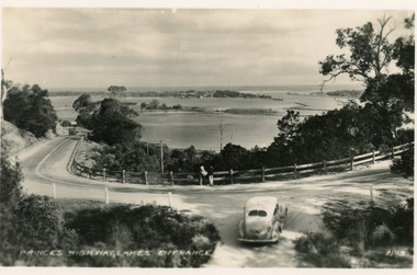
Postcard, Valentine Series, 1930c
Black and white postcard of a bend in the Princes Highway as it winds around Jemmys Point, car parked beside highway, two people leaning on post and rail fence, Bullock Island and Lakes Entrance in the distance. Lakes Entrance VictoriaPrinces Highway Lakes Entrancefences, transport, roads and streets -
 Lakes Entrance Regional Historical Society (operating as Lakes Entrance History Centre & Museum)
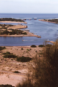
Photograph, 1995c
Colour photograph of the entrance from Bass Strait to the Gippsland. It shows the western and of Bullock Island and the built up area below Jemmys Point, all made during dredging operations over many years. Lakes Entrance Victoriafishing industry, islands, land reclamation, waterways -
 Lakes Entrance Regional Historical Society (operating as Lakes Entrance History Centre & Museum)
Photograph, Fish Marie, 1995
Also another black and white photograph of cleared site of Pecks factory 01611.1Black and white photograph of Bullock Island. It shows the site of Pecks fishing processing factory being cleared, Kalimna Heights in background taken from New Works area of southern shore of Cunninghame Arm. Lakes Entrance Victoriaislands, dredging, transport, machinery -
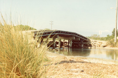 Lakes Entrance Regional Historical Society (operating as Lakes Entrance History Centre & Museum)
Photograph, Fish Marie, 1965
Also one other photograph, similar viewColour photograph of the first road bridge from Lakes Entrance to Bullock island, which was built for Public Works Dept. groyne building and sand build up to enlarge the island. Built early 1953. Lakes Entrance Victoriawaterways, topography, transport, room display -
 Bendigo Historical Society Inc.
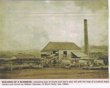
Newspaper - JENNY FOLEY COLLECTION: BUILDING OF A BUSINESS
Bendigo Advertiser '' The way we were'' from 2002. Building of a business: unloading logs at Hume and Iser's saw mill with the help of a bullock team owned and driven by William Densley, of Burnt Gully; late 1880s. The clip is in a folder.newspaper, bendigo advertiser, the way we were -
 Bendigo Historical Society Inc.
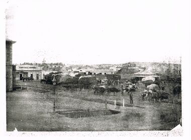
Photograph - WES HARRY COLLECTION: MARKET SQUARE, BENDIGO
Black and white photo: image shows bullock team in Market square. Town Hall Hotel in background, Town hall building just visible on LH side. Rectangular drainage pit in forefront of image, lamp post beside.Batchelderplace, bendigo, market square, bendigo, sandhurst, market square, town hall hotel, town hall -
 Lake Bolac & District Historical Society
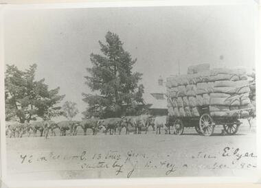
Black and white photograph, Bullock drawn wool wagon, "Eilyer"
Bullock wagon carting "Eilyer" wool in November, 1903. Wagon carrying 72 bales or 13 tons of wool. Team is driven by J E Fry.wool, bullock team, 1903, eilyer, -
 Lakes Entrance Regional Historical Society (operating as Lakes Entrance History Centre & Museum)
Photograph, Lakes Post Newspaper, 1/12/1992 12:00:00 AM
Also a black and white photograph of Bob Hodgson with four of his bullocks pulling a wooden sled number 3905.1 size 12 x 15 cmBlack and white photograph of Bob Hodgson pioneer skills enthusiast and proprietor of Lyrebird Motel Lakes Entrance Victoriabusinesses -
 Phillip Island and District Historical Society Inc.
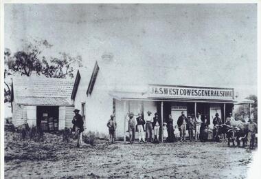
Photograph, c 1900
Original photograph was copied and enlarged for museum display.Black & White enlargement of a photograph of the J & S West Cowes General Store in Thompson Avenue Cowes. People standing on verandah in front of the store. Bullock team right front of picture. The original photograph is catalogue/registration no. 154-10.j & s west general store cowes phillip island, cowes general store phillip island -
Glenelg Shire Council Cultural Collection
Photograph - Photograph - Henty Beach, Portland Victoria, 19/11/1934
Black and white photo. Henty Beach, Portland, Centenary celebrations, 19 Nov. 1934. Harbour, piers, ships, bullock team, slab hut, background; a number of horses and riders middle-ground, spectators, mostly wearing hats, in foreground -
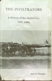 Heytesbury District Historical Society Inc.
Book, The Shire of Heytesbury, The Infiltrators :A History of the Heytesbury 1840-1920 by Jack S. Fletcher, First Edition 1985
The book relates to the triumphs & the achievements, the hardships & the tribulations, of the pioneers & settlers of the district.This book gives a detailed history of the Heytesbury district, including the settlerment of the townships of Port Campbell, Timboon, Princetown. This incorporates the development and establishment of industry, commerce, agriculture, education and social and religious events. Reference to families from the area are listed in index. This book is one of 2 by the author. The other accompanying book is titled "And We Who Followed: A History of the Heytesbury, 1921-1987", and follows "The Infiltrators".A tan hard cover book with title in gold lettering & a dust cover with a photo of a bullock team & wagon carting a large log, with two bullockies driving. The book has a locality map.contents,index,ledger entries & black & white photographschurches, education, agriculture, history, port campbell, pioneers, timboon, cobden, heytesbury, princetown, sports -
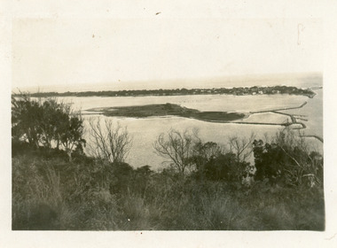
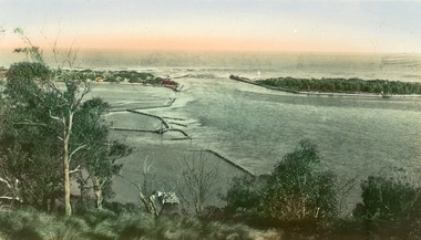
 Lakes Entrance Regional Historical Society (operating as Lakes Entrance History Centre & Museum)
Postcard, 1935c
Also small format identical postcard 6.5 x 8.5, very faded,|also small format photo, same view donated by D & M FletcherBlack and white small format postcard of the man made entrance to the Gippsland Lakes, taken from Jemmys Point. It shows the rock groynes beside Bullock Island, a barge in North Arm below Jemmys Point. Lakes Entrance VictoriaThe Entrance to Gippsland Lakeshouses, waterways, topography -
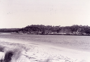
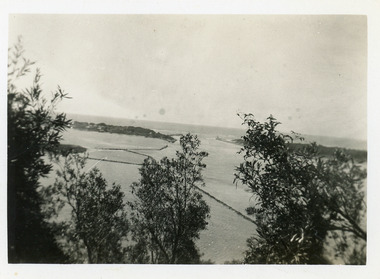
 Lakes Entrance Regional Historical Society (operating as Lakes Entrance History Centre & Museum)
Photograph, 1930c
Black and white photograph of Bullock Island, showing the footbridge to the island, the rock groynes at the western end of the island, built to direct flood and tide waters to entrance. Photo taken from Kalimna Hill, scub in foreground. Lakes Entrance Victoriawaterways, islands, township -
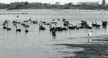 Lakes Entrance Regional Historical Society (operating as Lakes Entrance History Centre & Museum)
Photograph, Lakes Post Newspaper, 1991
This image appeared in Lakes Post 27 May 1991 Page 3|This is the before paired photograph used in the 150 year Lakes Entrance 1858-2008 display.|The after paired photograph number is 01604.1.|Also one 12 x 16 framed photograph used in room display.Black and white photograph of Bullock Island, It shows fishing Co-Operative buildings, Pecks fish processing factory. Three groups of swans on Cunninghame Arm, plus lone black headed Ibis fishing in the shallows. Lakes Entrance Victoriaislands, fishing industry, safety -
Lakes Entrance Regional Historical Society (operating as Lakes Entrance History Centre & Museum)
Photograph, Eastwood Bros, 1889c
Sepia photograph showing the just opened Entrance to Bass Strait. Sand not completely cleared from channel, buildings on dunes, dredge Wombat moored off Bullock Island. Rock groynes being built in lake. Lakes Entrance Victoriawaterways, islands, jetties, houses -
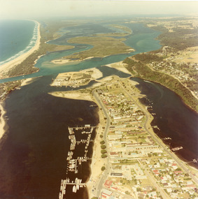 Lakes Entrance Regional Historical Society (operating as Lakes Entrance History Centre & Museum)
Photograph, 1980c
Colour photograph aerial view of township of Lakes Entrance, showing western end of town, Bullock Island, Cunninghame Arm and North Arm, man made entrance, and distant view of outer barrier, island and shoreline. Lakes Entrance Victoriawaterways, township, restaurant, bridges -
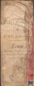 Bendigo Historical Society Inc.
Document - INDENTURE DOCUMENT BETWEEN JAMES NORTHCOTT AND WILLIAM ANDERSON
Indenture document, hand written in ink and ruled in red ink, between James Northcott, farmer and William Anderson ' of the same place' for 380 acres at Bullock Creek. Document is in poor condition and folded in four sections. Document dated 1870.rural industry, farm property, indenture northcott and anderson -
Glenelg Shire Council Cultural Collection
Souvenir - Salt and Pepper Shakers, 1984
China salt and pepper shakes. Shape of oven and basin, beige and brown. Oven flat one side, black stamp, bullock dray, '150th Anniversary' in banner above dray; 'VICTORIA' in banner beneath dray. Identifying numbers 6232 a, b -
Lakes Entrance Regional Historical Society (operating as Lakes Entrance History Centre & Museum)
Postcard, Rose Stereograph Co Armidale Vic, 1940 c
Black and white postcard taken from Jemmys Point showing the Entrance, groynes at the entrance to North Arm and around Bullock Island and portion of New Works area. Two small boats moored in main channel Lakes Entrance Victoria P10722The Entrance Lakes Entrance Victoriafences, roads and streets, waterways -
Lakes Entrance Regional Historical Society (operating as Lakes Entrance History Centre & Museum)
Photograph, John Flynn, 1906
Bridge was built in 1896 and never finishedBlack and white photograph of bullock team pulling timber jinker with very long logs across the Buchan River beside the footbridge. Several men in charge of team and four girls on the hill, cottage and barn seen, bridge not finished Buchan VictoriaCrossing the Buchancaravan parks -
Lakes Entrance Regional Historical Society (operating as Lakes Entrance History Centre & Museum)
Photograph, Gippsland Ports, 2006 c
Second copyColour aerial photograph of entrance from Bass Strait to Gippsland Lakes including Bullock Island Reeves Channel Rigby Island houses on Kalimna Hill and Princes Highway winding down Jemmys Point hill into township of Lakes Entrance Victoriaaerial photograph, ocean, waterways -
 Lakes Entrance Regional Historical Society (operating as Lakes Entrance History Centre & Museum)
Postcard, Valentine Series, 1935c
Hand tinted postcard of the man-made entrance to the Gippsland Lakes, taken from Jemmys Point. It shows the rock groynes at Bullock Island and Entrance to North Arm, a barge in North Arm directly below Jemmys Point. Lakes Entrance Victoriaislands, waterways, topography -
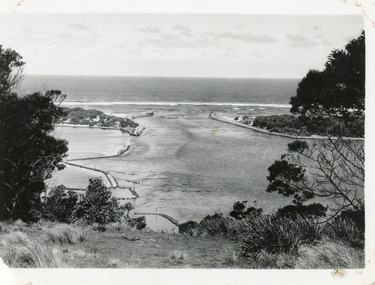 Lakes Entrance Regional Historical Society (operating as Lakes Entrance History Centre & Museum)
Photograph, 1930c
Black and white photograph showing wooden piers at entrance to Bass Strait from the Gippsland Lakes. Buildings on sand dunes, Bullock Island and rock groynes. Photo taken from Jemmys Point showing shrubbery in foreground. Lakes Entrance Victoriawaterways, topography, boats and boating, islands -
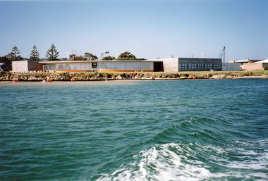
 Lakes Entrance Regional Historical Society (operating as Lakes Entrance History Centre & Museum)
Photograph, 1995c
Colour photograph of the entrance from Bass Strait to the Gippsland Lakes, it shows the western end of Bullock Island and the built up area below Jemmys Point, both made during dredging operations over many years. Lakes Entrance Victoriaislands, fishing industry, waterways, tourism -
 Lakes Entrance Regional Historical Society (operating as Lakes Entrance History Centre & Museum)
Photograph, 2005
Date made September 2005Colour photograph of the RMIT TAFE Educational Facility on Bullock Island, taken from the Cunninghame Arm. It shows the brick administration building, and the timber SEAMEC building. To the right of the photo is Lakes Entrance Fishermens Co-op building. Lakes Entrance Victoriaarchitecture, islands, tourism -
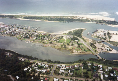 Lakes Entrance Regional Historical Society (operating as Lakes Entrance History Centre & Museum)
Photograph, 1997c
Colour print of aerial view looking south of western side of township. Shows housing on Kalimna Hill, North Arm, part of Bullock Island, Cunninghame Arm, the outer barrier and east pier of man made entrance. Lakes Entrance Victoriawaterways, islands, dredging, accommodation -
Bendigo Historical Society Inc.
Map - SALISBURY : COUNTY OF BENDIGO, 1965
Map. Salisbury, County of Bendigo, Pompapiel, Yallook, Yarraberb, Yarrayne, Bullock Creek. Drawn and reproduced at the Department of Lands and Survey, Melbourne. Price $1.00. 1965. By authority A.C. Brooks, Government Printer, Melbourne. (number 28 in map cupboard 1)A.C. Brooks,Government Printer, Melbourne.map, bendigo, salisbury -
Bendigo Historical Society Inc.
Map - SALISBURY : COUNTY OF BENDIGO, 1965
Map. Salisbury, County of Bendigo, Pompapiel, Yarrayne, Yarraberb, Yallook, Bullock Creek. By Authority: A.C. Brooks, Government Printer, Melbourne. Drawn and reproduced at the Department of Lands and Survey, Melbourne.1965. Price $1.00. (number 6 in map cupboard 1)A.C. Brooks, Government Printermap, bendigo, salisbury -
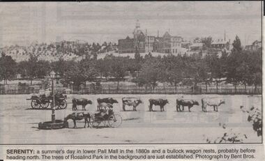 Bendigo Historical Society Inc.
Newspaper - JENNY FOLEY COLLECTION: SERENITY
Bendigo Advertiser "The way we were" from 1999. Serenity: a summer's day in lower Pall Mall in the 1880s and a bullock wagon rests, probably before heading north. The trees of Rosqalind Park in the background are just established. Photograph by Bent Bros.newspaper, bendigo advertiser, the way we were -
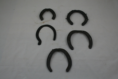 Emerald Museum & Nobelius Heritage Park
Horse-Shoes
George Walter A'Vard was a bullocky who worked all through the Dandenongs from 1900 to 1928, where he sold his bullocks. He settled in Emerald in 1920.VEMU1613.1 Eight holes and 7 nails. 13.5cm (H); 12.8cm (W); 4mm (D). VEMU1613.2 Eight holes. 14cm (H); 10.8cm (W); 3mm (D). VEMU1613.3 Six holes. 10cm (H); 9.5cm (W); 6mm (D). VEMU1613.4 Five nails. 12.5cm (H); 12.1cm (W); 7mm (D). VEMU1613.5 Five holes, 1 nail. 13cm (H); 11.5cm (W); 2mm (D).