Showing 741 items
matching charts
-
 Glenelg Shire Council Cultural Collection
Document - Document - Conversion chart decimals, n.d
Port of Portland Authority Archivesport of portland archives -
 National Wool Museum
Photograph - Hair Follicles Chart, J W Allen, 1900 - 1940
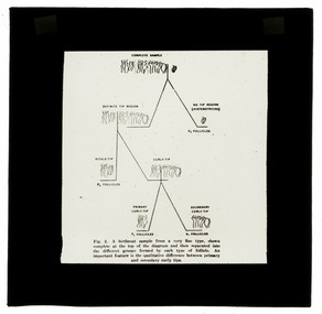
This item is part of a collection of twenty black and white glass lantern slides previously housed together in an old cardboard box. [8611 - 8630] The slides are part of a greater collection of around forty three black and white glass lantern slides, along with other photographs and photo albums related to this collection. This item is associated with the New South Wales Graziers Association world tour of merino sheep 1928/9. The slides were possibly used as supporting material in presentations made by J W Allen when on tour.Black and white glass lantern slide with paper edging depicting a chart showing variations in hair follicles.new south wales graziers association, travel, cattle, agriculture, j w allen, photography, glass lantern slide -
 Bendigo Historical Society Inc.
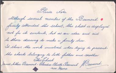
Document - RANDALL COLLECTION: BEAMENT FAMILY TREE
Document, Beament Family Tree, Sign Reads: Please note , although several members of the Beament family attended this school( Gravel Hill School), this chart is not for its contents, but as an idea and aid to those desiring to make a family tree. It shows the work involved when trying to present the charts belonging to both Father and Mother. This Chart, James Arthur Beament - Claudine Olivette Beament nee Moore. Picture on reverse has no name, or to where it might be.bendigo, education, gravel hill primary school -
 Flagstaff Hill Maritime Museum and Village
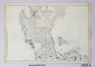
Document - Navigation Chart, Cabra I. to San Fernando Pt and Dilasak B to St. Miguel B
British Admiralty Navigation Chart. Cabra I. to San Fernando Pt and Dilasak B to St. Miguel Bwarrnambool, shipwrecked-coast, flagstaff-hill, flagstaff-hill-maritime-museum, maritime-museum, shipwreck-coast, flagstaff-hill-maritime-village, shipwrecked-artefact, british admiralty navigation chart, navigation chart, cabra i. to san fernando pt and dilasak b to st. miguel b -
 Flagstaff Hill Maritime Museum and Village
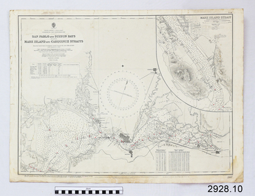
Document - Navigation Chart, California - San Pablo and Suisun Bays including Mare Island and Carquinez straits
British Admiralty Navigation Chart - California - San Pablo and Suisun Bays including Mare Island and Carquinez Straitswarrnambool, shipwrecked-coast, flagstaff-hill, flagstaff-hill-maritime-museum, maritime-museum, shipwreck-coast, flagstaff-hill-maritime-village, shipwrecked-artefact, british admiralty navigation chart, navigation chart, california, suisun bay, san pablo bay, mare island strait, carquinez straitt -
 Flagstaff Hill Maritime Museum and Village
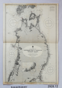
Document - Navigation Chart, Japan, Ishinomaki Wan ( Sensai Bay) and Sakata Ko to Tsugaru Kaikyo (Strait)
British Admiralty Navigation Chart -- Japan, Ishinomaki Wan ( Sensai Bay) and Sakata Ko to Tsugaru Kaikyo (Strait)warrnambool, shipwrecked-coast, flagstaff-hill, flagstaff-hill-maritime-museum, maritime-museum, shipwreck-coast, flagstaff-hill-maritime-village, shipwrecked-artefact, british admiralty navigation chart, navigation chart, ishinomaki wan ( sensai bay), sakata ko to tsugaru kaikyo (strait) -
 Flagstaff Hill Maritime Museum and Village
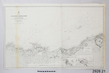
Document - Navigation Chart, C. Bougaroni to Fratelli Rocks including the Galita Channel
British Admiralty Navigation Chart - Africa, North Coast - C. Bougaroni to Fratelli Rocks and including The Galita Channelwarrnambool, shipwrecked-coast, flagstaff-hill, flagstaff-hill-maritime-museum, maritime-museum, shipwreck-coast, flagstaff-hill-maritime-village, shipwrecked-artefact, british admiralty navigation chart, navigation chart, c. bougaroni to fratelli rocks including the galita channel -
 City of Moorabbin Historical Society (Operating the Box Cottage Museum)
Document - Genealogy Chart Henry Dendy (Photocopy), 19 thC
In 1840 Henry Dendy, a farmer in Surrey, England acquired a "Special Survey" from the Commissioners for Land and Emigration which gave Dendy the right to choose land in Port Phillip for the "bargain basement" price of only £1 per acre for 5120 acres, (an area of 8 square miles). The Special Survey also included the right to "the shipment of a worker for every £20 spent on land, whose free passage was paid by the Crown, equalling a total of 100 workers ". Accordingly Dendy sold his English holdings and paid the required £5120 and arrived in Melbourne in February 1841. However by this time land in the new colony was selling for £5 - £40 per acre. Because Henry Dendy possessed the order from the Colonial Office in London he was able to successfully oppose Super-intendant LaTrobe's attempts to alter the price of the land. Dendy appointed Jonathan Were, (an entrepreneur, who had arrived in 1839), as his Manager and who later became a partner. Together, Dendy and Were decided on an area 5 miles south from Melbourne, bounded by North Road, East Boundary Road, South Road and to the west by Port Phillip Bay. Were and Dendy pitched their tents in the area now known as ' Park St, Brighton' and sank a well near the corner of 'St Andrew's St and Wells St'. By 1845 J.B Were and Company had bought almost half of Dendy's land and Were built himself "Moorabbin House" in Were St Brighton made from stone, quarried from local cliffs. It was still standing in 1924. Legend records Moorabbin is named after the Aboriginal word for ' Mother's Milk ' The soil is very fertile and well supplied with water especially in the area called 'East Brighton' - now known as Bentleigh and East Bentleigh - By 1850 the area had developed with numerous market gardens, dairy farms, fruit gardens and vineyards supplying food for the growing population of Melbourne.In 1840 Henry Dendy, a farmer in Surrey, England acquired a "Special Survey" from the Commissioners for Land and Emigration which gave Dendy the right to choose land in Port Phillip for the price of only £1 per acre for 5120 acres. This land was called Brighton in the Parish of Moorabbin, County of Bourke and emigrants developed the land establishing market gardens , dairy and poultry farms that provided the food for the growing population of Melbourne. A photocopy of the Genealogy Chart of the Dendy Family that Henry Dendy brought with him when he emigrated to Melbourne 1841Genealogy signs and descriptionsdendy henry, dendy's special survey brighton 1841, governor gipps, captain lonsdale, super-intendant latrobe, port phillip, melbourne, new south wales, squatters, emmigrants, county of bourke, parish of moorabbin, early settlers, pioneers, market gardeners, dairy farmers, fruit farms, moorabbin, bentleigh, brighton, cheltenham, were jonathan binn, -
 Federation University Historical Collection
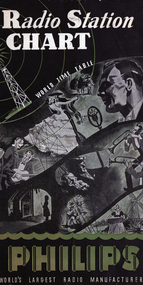
Booklet, Radio Station Chart
Black, green and white folded chart giving transmission schedule of principal shortwave station and Australian Broadcasting Stations. radio, philips, radio station, short wave stations, transmission schedule, world time-table, hourly chart, broadcasting stations, shortwave -
 Hume City Civic Collection
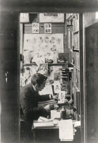
Photograph, 1920s
Eric Boardman continued to print the Sunbury News after the death of his father, Arthur, and until the newspaper was taken over by The Regional Group in 1965. Eric Boardman continued to work as a journalist for the paper until his death in 1977.A black and white photograph of a man sitting at a desk working. There are charts on one wall and book shelves facing the man.sunbury news, boardman, eric, arthur, george evans collection -
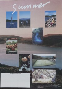 Falls Creek Historical Society
Booklet - Falls Creek Lodge & Apartment Guide Summer 1992
A part of a yearly marketing and information material promoting Falls Creek. This leaflet focuses on activities and accommodation in Falls Creek Village in the summer. Venues included are:- Astra Lodge, Diana, Halley's Lodge, Silver Ski, Snowdrift, Alpine View Apartments and Koki Apartments.This item is important as it documents different approaches to marketing Falls Creek Village, Victoria. An A4 size leaflet promoting several businesses in Falls Creek. An accommodation rates chart is included in the centre page.skiing, ski, falls creek, victoria, school holidays, winter, snow, winter sport, 1990s, marketing, graphic design -
 Robin Boyd Foundation
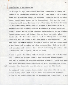
Document - Manuscript, Robin Boyd, Architecture in the Seventies
Boyd outlines the focus of the Modern Movement: function determining form and the rejection of ornamentation; outlines three phases of Modernism: the plain informal functionalist box style; 1950s monolithic sculptural forms (eg TWA terminal); and fragmented systematic expandable forms. Boyd proposes a new phase: a New Revolution Against Architecture, wherein the barriers between art and science are broken down and combined with technology; suggests looking to Japanese Metabolism.Typewritten, pencil edits, quarto, 21 pagesPage 1 refers to a chart (not attached). Sporadic annotations throughout. Appears to be a talk. Pages 6-8 refer to a chart, page 11 refers to an image of apartments by James Stirling, p14 refers to Robert Venturi's Guild House.page 1 refers to a chart (not attached). sporadic annotations throughout. appears to be a talk. pages 6-8 refer to a chart, page 11 refers to an image of apartments by james stirling, p14 refers to robert venturi's guild house -
 Bendigo Military Museum
photograph - Cartographic Squadron Production – Army Survey Regiment, Fortuna, c1980
This collection of 12 photos was most likely taken in 1980. The photos were most likely taken in Cartographic Squadron’s Ante Room, the Attic and small offices on the top floor of Fortuna Villa. The computer based Editwriter typesetting system was introduced in 1975 as a replacement to the aging Fotosetter machine. It was operated by a specialised technician, who generated a large variety of map type styles and sizes quickly and reliably, as well as text panels. CPL Richards performed this task for several years and in photo .1P and .2P is reading off a type order next to the computer monitor. Output on Copy proof adhesive backed stripping type film replaced messy wax and spray adhesives in 1978. The Editwriter capability supported all RASvy units and contractor type setting requirements. Scribing was the cartographic process of drafting features such as drainage, relief, vegetation, roads and culture on specially coated map reproduction material. The cartographic technician scribed out the map feature such as a contour to a specified line width on the map sheet, using a tool affixed with a sapphire tipped cutter. The quality control edit (Proving) stage of map production was the first opportunity to inspect a proof of the map independently and systematically. Proving tasks were carried out by technicians conversant of the map product specification and task requirement, however, was not involved in its production. Corrections were identified, marked up and sent to back to the correcting section or contractors. Terrain Embossing was a manual map production technique to produce hill shading on medium to small scale graphics and air charts. SPR John Martin is seen in photos .8P to.10P using a fine embossing metal stylus to push down on the drainage impression on a thin malleable opaque plastic material (AK Poligraphy). Ridge lines were then pushed down using the contour impression as a guide, on the opposing side of the AK Poligraphy to create a 3D plastic model terrain effect. The map impression was sprayed with white paint and photographed to create a contone tone hill shade. SPR Gina (Coore) Neilson is seen in photo .11P washing a contone positive of a land mass in a solution. The contone components were registered to the map sheet, as shown in photo .12P and masked using an air brush and a halftone negative was then created. The terrain embossing method of producing hill shading was more efficient to produce than previous specialised artistic methods such pencil/eraser and air brush. Furthermore, a more consistent enhancement of terrain on charts was achieved between technicians.This is a set of 12 photographs of Cartographic Squadron performing four map production tasks at the Army Survey Regiment, Fortuna, Bendigo c1980. The first ten photographs were on 35mm negative film and were scanned at 96 dpi. Photos .11P and .12P were on photographic paper and scanned at 300 dpi. They are part of the Army Survey Regiment’s Collection. .1) - Photo, black & white, c1980, Editwriter typesetter, CPL Paul Richards. .2) - Photo, black & white, c1980, Editwriter typesetter, CPL Paul Richards. .3) - Photo, black & white, c1980, Scribing contours on a RAAF Chart, SPR Megan (McBurney) Reynolds. .4) - Photo, black & white, c1980, Scribing contours on a RAAF Chart, SPR Megan (McBurney) Reynolds. .5) - Photo, black & white, c1980, Scribing contours on a RAAF Chart, SPR Rod Skidmore. .6) - Photo, black & white, c1980, Scribing contours on a RAAF Chart, SPR Rod Skidmore. .7) - Photo, black & white, c1980, Formal quality control edit (Proving), CPL Ian Belmont. .8) - Photo, black & white, c1980, Hill Shade Terrain Embossing, SPR John Martin. .9) - Photo, black & white, c1980, Hill Shade Terrain Embossing, SPR John Martin. .10) - Photo, black & white, c1980, Hill Shade Terrain Embossing, SPR John Martin. .11) - Photo, black & white, c1980, Hill Shade Terrain Embossing, SPR Gina (Coore) Neilson. .12) - Photo, black & white, c1980, Hill Shade Terrain Embossing, unidentified..1P to .10P No personnel are identified. .11P and .12P annotated ‘Terrain Embossing’royal australian survey corps, rasvy, army survey regiment, army svy regt, fortuna, asr, carto -
 Greensborough Historical Society
Genealogical chart, Descendants of George William Stock, 1861o
Family history chart of pioneer familyHistory of the Stock and Blackbourn families.Black and white 10 page computer generated family tree.In pen on front page: Val Wilsonchapman stock family, blackbourn family, family trees -
 Lara RSL Sub Branch
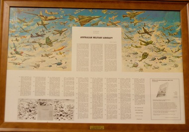
Framed Picture of Australian Military Aircraft 1954 - 1971, Australian Military Aircraft
Picture of Australian Military Aircraft 1954 to 1971 The sixth and final war chart in the series reproducing the War Memorial mural painted by Harold Freedman. This concludes the 50th anniversary of the australian Airforce. Chart 6Pictorial history of Australian Military aircraft from 1954 to 1971Print in wooden glass frameAustralian Military Aircraft Donated by Pedro Pegan 2015military aircraft australia -
 Geoffrey Kaye Museum of Anaesthetic History
Photograph
Black and white photograph of a McKesson Nargraf anaesthetic record. The chart is for patient R.W's anaesthetic record, a 31 year old male for a right inguinal hernia operation on 2/5/1938. The anaesthetist listed is K. The chart lists the times and notes from the procedure, starting at 10.22am and ending at 11.27.mckesson nargraf anaesthetic record, anaesthetic chart -
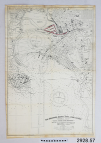 Flagstaff Hill Maritime Museum and Village
Document - Navigation Chart, The Melbourne Harbor Trust Commissioners
Navigation Chart - The Melbourne Harbor Trust Commissioners - General Plan - Shewing proposed Harbor Improvements. Hobson's Bay and Citywarrnambool, shipwrecked-coast, flagstaff-hill, flagstaff-hill-maritime-museum, maritime-museum, shipwreck-coast, flagstaff-hill-maritime-village, shipwrecked-artefact, navigation chart, hobson's bay, the melbourne harbor trust -
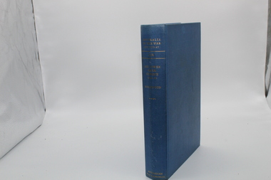 Lara RSL Sub Branch
Book, Australia in the War of 1939-1945 - Air Power Over Europe 1944-1945 Volume 4. AIR. Author John Herington, First Published 1963
A continuation and conclusion of the story of Australian airmen who served in or beside the RAAF in the struggle against Germany and Italy. In general it covers a period when both in the Mediterranean and in Northern Europe Air superiority, the vital pre-requisite of successful air assault, had already been gained over the enemy. The emphasis is largely engagements or in the strategic bombing campaigns to the total achievement of allied air power in land and sea campaigns.Historical record of the Air power over Europe 1944-1945Australia in the War of 1939-1945 - Air Power Over Europe 1944-1945. AIR Maps, Illustrations, charts, photographsAustralian War Memorialinvasion of italy, long range missiles, oil, normandy, coastal command, ardennes offensive, battle of the bulge, evaders, prisoners, rhine, air force 1944-1945, wwii, 453 squadron, 646 squadron, spitfire, ground crew, no.3 squadron, 461 squadron, 466 squadron, 455 squadron -
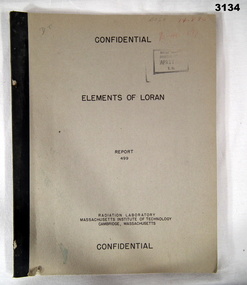 Bendigo Military Museum
Book - BOOK, NAVIGATION, Radiator Laboratory, Massachusetts Institute of Technology, Elements of LORAN, Report 499, 1944
LORAN is a radio navigation system.Marked Confidential. Khaki coloured soft cover book with black print. Illustrated with drawings, charts, mathematics, 45 pages.Some random numbers written on front top right.books reference/military/manuals, naviggation, radio -
 Federation University Historical Collection
Booklet, Education Department Victoria Technical Schools Register for Classes in Building and Construction., c1981, 1981
Blue hard covered book with red tape. Instructor was J. White. Includes a chart on mathematical skills, and student names.ballarat school of mines, trades, j. white, mathematics -
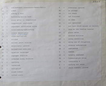
Glenelg Shire Council Cultural Collection
Document - Document - Conversion Chart, n.d
Port of Portland Authority Archivesport of portland archives -
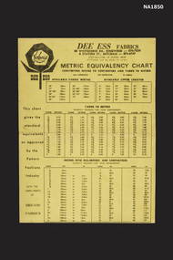 Whitehorse Historical Society Inc.
Poster - Metric Chart
Metric equivalency chart explaining conversion from imperial measurement to metric as advertising material from Dee Ess Fabrics.commerce, advertising -
National Wool Museum
Chart, Australia's Wool Industry Processing chart, 1960
"Australia's Wool Industry Processing chart, 1960"education wool industry textile industry - education, australian wool board, galloway, mr ken, education, wool industry, textile industry - education -
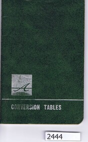 Greensborough Historical Society
Booklet, Conversion tables, 1967_05
Conversion, equivalents and weights and sizes charts for engineering applications.64 p., tablesconversion tables, metric conversion -
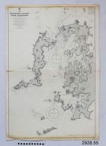 Flagstaff Hill Maritime Museum and Village
Document - Navigation Chart, Pescadores Islands Inner Anchorage
British Admiralty Navigation Chart - China - Formosa Strait - Pescadores Islands Inner Anchorage, from a French Goverment Survey 1886warrnambool, shipwrecked-coast, flagstaff-hill, flagstaff-hill-maritime-museum, maritime-museum, shipwreck-coast, flagstaff-hill-maritime-village, shipwrecked-artefact, navigation chart, british admiralty navigation chart, british admiralty, pescadores islands inner anchorage -
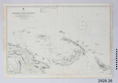 Flagstaff Hill Maritime Museum and Village
Document - Navigation Chart, North-East Coast of New Guinea with Bougainville, New Britain, New Ireland & Admiralty Islands
British Admiralty Navigation Chart - North-East Coast of New Guinea with Bougainville, New Britain, New Ireland & Admiralty Islandswarrnambool, shipwrecked-coast, flagstaff-hill, flagstaff-hill-maritime-museum, maritime-museum, shipwreck-coast, flagstaff-hill-maritime-village, shipwrecked-artefact, british admiralty navigation chart, navigation chart, new guinea, bougainville, north-east coast of new guinea, new britain, new ireland, admiralty islands -
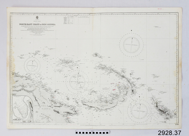 Flagstaff Hill Maritime Museum and Village
Document - Navigation Chart, North-East Coast of New Guinea
British Admiralty Navigation Chart - North-East Coast of New Guinea with Bouganville, New Britian, New Ireland and Admiralty Islandwarrnambool, shipwrecked-coast, flagstaff-hill, flagstaff-hill-maritime-museum, maritime-museum, shipwreck-coast, flagstaff-hill-maritime-village, shipwrecked-artefact, navigation chart, british admiralty navigation chart, british admiralty, new guinea -
Glenelg Shire Council Cultural Collection
Work on paper - Work on paper - Conversion Charts, n.d
Port of Portland Authority Archivesport of portland archives -
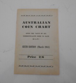 Bendigo Historical Society Inc.
Document - GRAHAM HOOKEY COLLECTION: AUSTRALIAN COIN CHART
Australian coin chart. Gives the value of all Commonwealth coins to date 1/2d to 5/- sixth edition (March 1964).books, technical, numismatic -
Clunes Museum
Work on paper - CHART, CHART NO 3 "THE HORSE"
PRINTED APPR. 1900 COLOURED POSTER/CHART DEPICTING EQUINE IMAGES AND ADVERTISING EQUINE SUPPLEMENTS DISTRIBUTED BY DAY,SON & HEWITTS APPR. MADE 1900equine, chart, poster, day son & hewitt's