Showing 3431 items
matching distance
-
 Lakes Entrance Historical Society
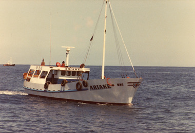
Photograph - Artake, 1980c
Colour photograph of the scallop fishing boat Artake at sea. Another fishing boat in distance. Lakes Entrance Victoriafishing industry, ships and shipping, waterways -
 The Beechworth Burke Museum
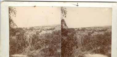
Photograph - Stereoscopic Photograph
This photograph offers a view of Beechworth, located at the foot of the Victorian Alps. It captures the gorge and native vegetation in the foreground, with the Beechworth township visible in the middle, where the hospital is marked with an arrow. Distant hills form the backdrop. Originally settled c1839, Beechworth was officially proclaimed a town in 1856.This photograph is historically significant as it captures the landscape of Beechworth, providing valuable insight into the town's visual and historical character.Two sepia-toned square photographs showing the view of a town with trees in the foreground and hills in the far distance, mounted.Obervse: Above the right photograph there is an arrow pointing down. Reverse: 97.2195/ View across the Gorge/ looking over Beechworth/ (Hospital under arrow)/ 84-110-1/ A03082beechworth, town, landscape, ovens district, stereoscopic -
 Wangaratta RSL Sub Branch
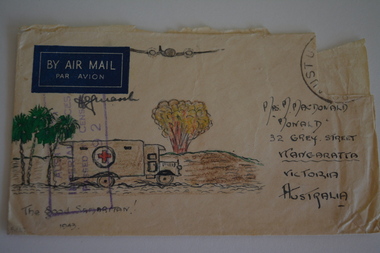
Work on paper - Envelope Art
One of several illustrated envelopes, without letter, sketched by soldier/s during the second world war and sent to Mrs MacDonald of WangarattaVictoria's 2/24th Infantry Battalion was raised in Wangaratta in July 1940. They were welcomed with open arms by the local community as they rapidly built up their numbers. The people of Wangaratta adopted the Battalion and they became known as "Wangaratta's Own" because of the time the battalion spent in the town during its formative period prior to deployment overseas. Many of the soldiers maintained life long friendships with the people of Wangaratta. Even though the Battation was disbanded in 1946 members and their families return each year, in November, for a commemorative service at the 2/24th Battalion Memorial Wall at the Wangaratta Cemetery.Cream paper envelope with coloured sketch of three palm trees an ambulance and plane overhead with bomb exploding in distance.Top left - BY AIR MAIL Top right - postage stamp Left side - AIF Censor stamp Right side - Mrs M MacDonald "Monald" 32 Grey Street Wangaratta Victoria Australia Bottom - "The good samaritan" 1943 ww2, envelope art -
 Lakes Entrance Historical Society
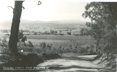
Photograph - Tambo River flats Bruthen Victoria, H D Bulmer, 1945 c
Black and white photograph of Tambo River flats and Bruthen in distance with maize crop growing on flats Bruthen Victoriafarming, agriculture, rivers -
 Lakes Entrance Historical Society
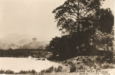
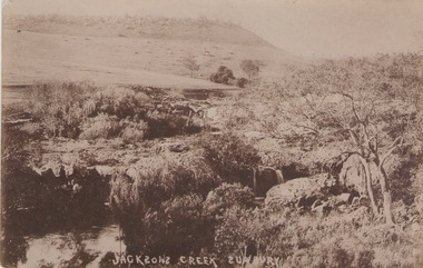
Postcard - Buchan Victoria, H D Bulmer, 1915 c
Sepia toned copy of postcard showing waterway with mountains in distance at Buchan Victoria. Also a second identical photographScene near Buchanagriculture, topography -
 Lakes Entrance Historical Society
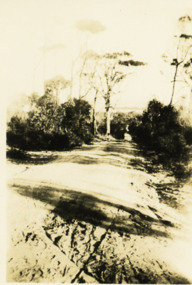
Photograph - Jemmys Point roadway, 1924
View of road down Jemmys Point, hummocks and lake just visible in far distance Lakes Entrance Victoriaroads and streets, topography -
 Flagstaff Hill Maritime Museum and Village
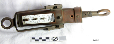
Ship Log, 1900-1920
Thomas Walker & Son was internationally renowned in the manufacturing of ships logs. Founding father Thomas Walker (1805–1871), an engineer in Birmingham, patented a mechanical log in 1878 which was a recording instrument that attached to a rail at the stern of a vessel connected by a long cord with a rotor which was towed behind the ship. The instrument dial recorded the distance travelled. Thomas Walker first went into business to manufacture stoves at 58 Oxford Street Birmingham. Walker’s self-feeding stove was widely lauded at the Paris Exhibition of 1855, winning a prize medal and kick starting the first of many notable innovations for the Walker family's manufacturing business. However, it wasn’t until working on an earlier ships log model invented by his Uncle that Thomas Walker became interested in the further development of this device, used to ascertain a ship’s speed. Walker continued to improve on the common log for the company of Massey & Sons and these improvements were deemed revolutionary. This log became a firm favourite of the West India Association (British-based organisation promoting ties and trade with the British Caribbean) and the most common log in use for two generations. It took till 1861 for Thomas Walker and his son, Thomas Ferdinand Walker (1831-1921) to patent the first Walker log of many. Together, with the introduction of the A1 Harpoon Log two years later, they established the Walker Log Business as a force to be reckoned with. By the time of his passing in 1871, Thomas Walker Snr had not only founded a family business with considerable staying power but also instilled a tradition of public service. Having sat as a representative on the Birmingham Town Council for 15 years and played an active role in public works, he was soon given the nickname of ‘Blue Brick Walker’. Much like his father, Thomas Ferdinand Walker changed the face of the maritime industry. His patent of 1897, the ‘Cherub’ log, was a notable departure from the past providing a far more accurate reading and replacing the majority of logs of the age. They were the first to produce an electric log and the Walker factory was one of the first to introduce the 48 hour work week for employees. This ship log was invented and made by a significant marine instrument maker and innovator of machinery. It demonstrates the huge leap taken to improve navigational accuracy at sea with an instrument that was in use for decades. Ship Log, three analogue dials calibrated in increments of Miles, the Rocket Log is a nautical instrument for measuring a vessel’s speed and distance traveled. The floating log was drawn behind the ship over a fixed time period in order to measure the distance traveled. The counter could measure enough miles to cover the maximum distance traveled by a ship in one day. The log has two distinct parts; a brass register, made by Walker, showing the distance recorded and the rotator made by Reynolds, that spins in the water driving the counter. both parts are connected by a linked chain. The register has a cylindrical brass body approx 4.5 cm diameter containing registering mechanism with hardened steel bearings. Distance is indicated by the three pointers on enamel plate as follows: graduated every 10 miles from 0-100; every mile from 1-10; every 1/4 mile from 1/4 -1. A brass sling and eye secured to the body enables it to be attached to the taffrail. The original rotator would have had a cylindrical tapered wooden body, approx 4.5 cm in diameter with three metal alloy fins or could be all made from brass. A towing eye is fitted to the tapered end. The two pieces of apparatus are connected by a length of linked chain, length 22.9 cm."Walkers Rocket Ship-Log Birmingham (Patented)" printed on face-plate. "Made by Thomas Walker".flagstaff hill, warrnambool, shipwrecked-coast, flagstaff-hill, flagstaff-hill-maritime-museum, maritime-museum, shipwreck-coast, flagstaff-hill-maritime-village, ship log, rocket log, mechanical ship log, measuring instrument, marine instrument, nautical instrument, speed recording instrument, ship log register, walker ship log, walkers rocket ship-log, thomas walker, thomas walker & son, thomas ferdinand walker, walker log business, reynolds ship log rotor, taffrail log, taff rail log, west india association -
 Phillip Island and District Historical Society Inc.
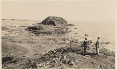
Photograph, 20th Century
Selection of 6 photographs and postcards of The Nobbies, A Seal and the SS Killara, donated by D Reid.A selection of postcards and photograph Black & White and Coloured of The Nobbies, a Seal and the SS Killara. Photo 1. View of the Nobbies with two people in the foreground. Photo 2. View of the Nobbies with a Horse and jinker in the foreground. Photo 3. A Seal resting on the rocks at Seal Rocks Phillip Island Photo 4. The Ferry steamer S. S. Killara arriving at Cowes Photo 5. Coloured view of the Nobbies looking across breakers on the rocks. Photo 6. Coloured coastal view looking towards the Nobbies in the distance.Inscriptions on the front of postcards Photo 2. The Rose Series. P 666. Looking to The Nobbies, Phillip Island, Victoria Photo 3. The Rose Series. P 747. A Seal on the rocks, Phillip Island, Victoria Photo 4. The Ferry Steamer S. S. "Killara" arrives at Cowes. Photo 5. The Nobbies, Cowes Photo 6. Coastal Scene Cowes. Nobbies in Distance.the nobbies phillip island, wildlife - seals, seal at seal rocks, ss killara, ferries -
 Bendigo Historical Society Inc.
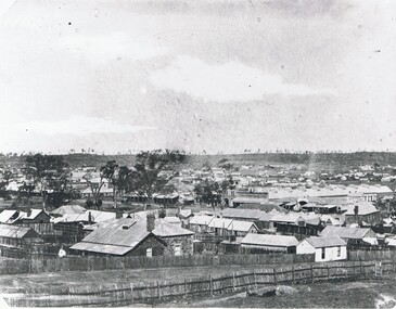
Photograph - STREETSCAPE: BENDIGO, 1857 ?
Black and white photograph. View of Bendigo Many small buildings, weatherboard, stone, paling. Trees on horizon, Beehive stores in middle distance. Rough vertical stick fences, fencs in foreground. Taken from high ground. In image on parapet of building in middle distance ' Francis Brothers Beehive Stores'A. Fox ( James Lerk 11.2.2000 )place, streetscape, bendigo -
 Phillip Island and District Historical Society Inc.
Photograph - Post Card, 1940's
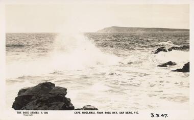
One of 11 photographs left in the museum for the Society by an anonymous donor.Black & White postcard taken after coming under the San Remo - Newhaven Bridge. Shows Cape Woolamai in the distance.The Rose Series P 706 Cape Woolamai, from Bore Bay, San Remo, Vic. 3.3.47. On back: "Cape Woolamai in background, after coming under San Remo bridge. Cape Woolamai highest point on Phillip Island."cape woolamai, cape woolamai phillip island, bore bay san remo -
 Phillip Island and District Historical Society Inc.
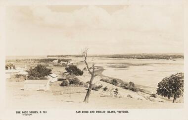
Sepia Photograph, 1920's
This album was presented to the Earl of Stradbroke by the Fathers of Soldiers and Returned Soldiers 16/02/1923Photograph of San Remo with early houses, possibly San Remo Hotel in the distance. Part of Phillip Island in back ground.Rose Series P701. San Remo and Phillip Island, Victoriaphillip island, san remo, earl of stradbroke, early houses -
 Eltham District Historical Society Inc
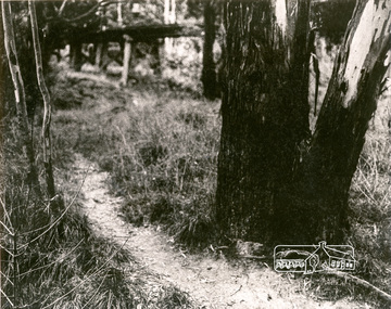
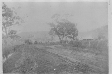
Photograph, Tree and Trestle Bridge, Eltham
Black and white photograph showing a track winding past an old gum tree towards the Trestle Bridge at Eltham in the distancepioneers and painters, bridges, eltham -
 Hume City Civic Collection
Photograph
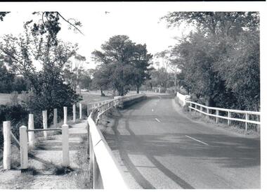
In the 1970s the bluestone bridge over Jackson's Creek ceased to be used and a wider bridge was constructed to its north. The curved approach to the bridge was taken out of the road and the old approach area was redeveloped and is now Apex Park.A black and white photograph of the old stone bridge over Jackson's Creek in Macedon Street. A utility is in the distance approaching the bridge.macedon street, jackson's creek, bridges, transport, apex park, sunbury, jackson's creek bridge, george evans collection -
 Hume City Civic Collection
Photograph, c late 1990s
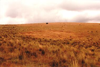
The series of 9 photographs were taken to be included in a study of archaeological sites and Aboriginal rings in the Sunbury area. Five earth rings which are thought to be associated with male initiation ceremonies have been identified in Sunbury. Only 3 others have been found in the rest of Victoria. Despite rapid development in the area, those sites are protected heritage sites.A coloured photograph of an Aboriginal Ring which is a proclaimed sacred site on an open grassy hillside. A black cow is standing in the distance.aboriginal culture, aboriginal rings, sacred sites, george evans collection -
 Hume City Civic Collection
Photograph, c 1990s
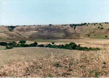
Canon Gully is situated about 2 km upstream from the railway bridge at Rupertswood. In 1864 it was the site for the military encampment of the Victorian Volunteer Forces. William Clarke allowed the military to stage the annual event on his property. Further encampments were held on this site in 1874 and 1877.A coloured photograph of a wide valley with cleared hills in the background. The tree lined creek or watercourse is across the middle distance of the image.canon gully, rupertswood estate, encampments, clarke, william j. t. 'big bull', victorian volunteer forces, george evans collection -
 Stawell Historical Society Inc
Photograph, Terang
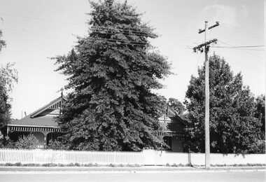
"Terang" - 33 Ligar St. - Hans Mitchell's HouseB/W Photograph: weatherboard House with verandah mostly hidden by tree. Picket fence and Power pole in mid-distance.stawell residence homes, terang, mitchell -
 Hume City Civic Collection
Photograph, The Nook, c1940
The Nook in Sunbury is situated on a wide and deep bend in Jacksons Creek. Today the area is a popular site for passive recreation with a walking path along the Jacksons Creek. The house on the RHS of the photograph was situated near Powlett Street.Before the Aquatic Centre was built in Sunbury the swimming pool at The Nook was the town's swimming pool for many years. Seats and a change area were at the site.A black and white photograph of a large bend in a river with a house built on its riverbank and another dwelling on the hillside in the middle distance.the nook, swimming, jacksons creek -
 Hume City Civic Collection
Photograph
The photograph is of the lake and grounds at Rupertswood. When the lake was first constructed is was said to be in the shape of Australia. It was also the place where many a romance started as couples met while being rowed across it in a Venetian style gondola.The lake at Rupertswood was a popular place where the Clarke family entertained their guests and was a significant landmark feature on the property.A non-digital black and white photograph with a cream border of a large lake set in an expansive garden with a large mansion in the distance.lakes, rupertswood mansion, gardens, sir wiliam john clarke, lady janet clarke -
 Mt Dandenong & District Historical Society Inc.
Photograph
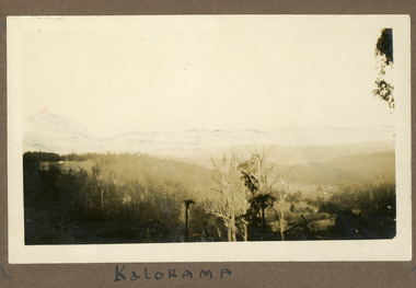
The photograph is from the album of Ivy My Child. The area depicted would be looking across the Kalorama Valley with the visible roof tops being the homes of the early settler families. Ivy May Child (1910 – 1989) was the daughter of Arthur Edward (Ted) Child (1878 – 1964) and Ethel May Madden (1888 – 1970). Ted Child was the son of Matthew Francis Child (1839 – 1933) and Martha Jeeves (1857 – 1926). He was the grandson of one of the early pioneers Francis Child. Ivy grew up on the family property on Childs Road and took many photographs. Most of these are glued into her photo album. The album covered the years from c1927 – 1932. Ivy married Henry William Burgess (1906 – 1968) in 1944. The photographs remain in their original state in the album with individual copies made. Black and white photograph with trees and bushes in the foreground and hills in the distance. White shapes scattered throughout the centre are the roofs of buildings.Written below the photograph in album: Kaloramakalorama valley, kalorama -
 Kew Historical Society Inc
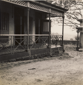
Photograph, Veranda, Kew Mental Hospital, 1954, 1954
This photograph is one of approximately 43 original photographs and photocopies of buildings, patients and staff assembled in a red covered, spirally bound photograph album (the album itself is now discarded and the images stored separately). The images in the album cover the period from the 1870s to 1965. A few photographs have inscriptions on the reverse; others had later separate labels in the album. The album was presumably compiled as a public record. It and other items came from the collection assembled by Dr Fred Stamp, the last medical superintendent of Willsmere Hospital before its closure in 1988. Original photographs have been uploaded to and described on Victorian Collections. The album itself is listed and linked separately showing the photographs in situ.A number of the photographs from the Willsmere Hospital album are confronting, especially given the condition of the buildings and facilities depicted, as well as the casual photographs of patients, which some viewers may find distressing. The album and its photographs are however an historically significant visual record of the Kew Mental Hospital, especially in the years 1951-1965.Black and white photograph of the edge of a veranda in the Kew Mental Hospital. What appears to be a HaHa! wall can be seen in the distance"1954"kew lunatic asylum, kew hospital for the insane, kew mental hospital, kew mental institute, willsmere mental hospital, willsmere hospital -
 Kew Historical Society Inc
Photograph - Urban landscape, 1860
An item from an outstanding and diverse photographic collection, assembled by members of the Christian and Washfold families of Kew.Black and white photograph looking across a valley to buildings in the distance. Similar locations in nos.41, 42, 43. 44.subdivisions -- kew (vic.), christian-washfold collection, landscape photography -
 Sunbury Family History and Heritage Society Inc.
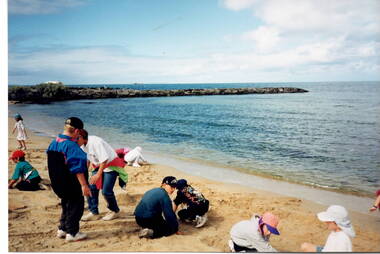
Photograph, Beach excursion, c Early 1996
One of the activities the children enjoyed at their Williamstown Beach excursion was a snd castle competition, which they are busy constructing.A non-digital photograph of a group of children at a beach by the water's edge and digging in the sand. A rocky breakwater is across the middle distance.school excursions, bulla primary schooil, williamstown beach, sand castles -
 Sunbury Family History and Heritage Society Inc.
Photograph
he photograph was taken of Jacksons Creek near the waterfalls and weir which are downstream from Macedon Street.A sepia photograph in postcard format of a creek with the water tumbling over rocks. The land in the distance rises above the surrounding valley.JACKSONS CREEK SUNBURYjacksons creek, sunbury -
 Sunbury Family History and Heritage Society Inc.
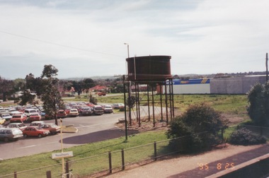
Photograph, 25th
The photograph of Sunbury was taken from the pedestrian bridge at the railway station and is looking NW to Horne Street and beyond. The water tower in the foreground was used to pump water into the steam train engines. Then commercial development on the site was built shortly before this photograph was taken.A coloured photograph of an elevated view of Sunbury with a metal water tower in the foreground and a car park with commercial buildings in the middle distance.sunbury, sunbury railway station, horne street -
 Lakes Entrance Historical Society
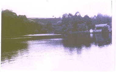
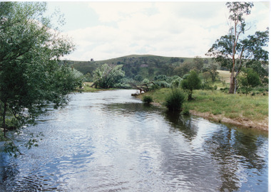
Photograph - Buchan River, Tambo Shire, 1994 c
Colour photograph of the Buchan river, showing stream flowing between low banks, hills rising in distance. Buchan Victoria topography, waterways -
 Lakes Entrance Historical Society
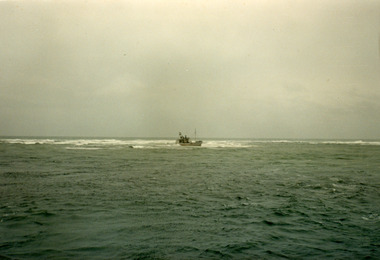
Photograph - Janet 1, Hammarstrom Ian, 1989 c
Colour photograph taken from a distance, showing the fishing boat Janet 1, stuck on the bar at Lakes Entrance, Victoria.ships and shipping, fishing industry, coast -
 Halls Gap & Grampians Historical Society
Photograph - B/W
This is a photo of Mason's house, on the road to Ladysmith in the Mt William gold fields.The photo appears to have been taken on a foggy day. It shows an unsealed road flanked by a few gum trees and with a ditch containing water on the left. On the right in the middle distance there is a house with a twin pitched roof and a veranda at the front. In the distance on the road is a vehicle and what appears to be a few people. The are mountains in the far background.buildings, houses -
 Lakes Entrance Historical Society
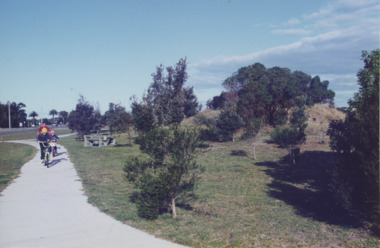
Photograph - Esplanade Lakes Entrance Victoria, Lakes Entrance Tidy Town, 1995 c
Colour photograph showing two children and an adult riding bicycles on pathway between south end of North Arm bridge and Bullock Island road. Middle distance left turn into Marine Parade foreground now site of skate park. In distance palm trees at entry to Esplanade Lakes Entrance Victoriarecreation, topography, roads and streets, parks -
 Flagstaff Hill Maritime Museum and Village
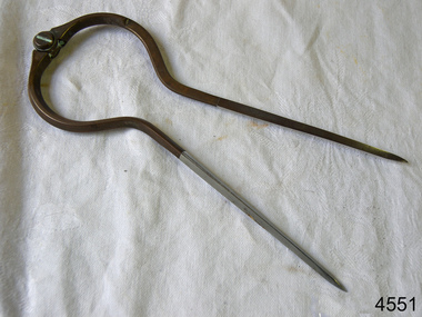
Dividers, Early 20th Century
Dividers are used by navigators to measure the distance between two points on a map or chart. Each point of the divider is places on a map point, then the distance between the points of the divider is measured against the scale of the chart or map. This helps determine the ship's path of travel, the distance travelled and the current location.Not very significant as not associated with any historical event or person, same pattern of dividers is available today from many retail outlets. Also item was probably made around 1940s to 1950sDividers; brass navigator's dividers with fine, stainless steel points. Made in Britain by W & H C (inscription). This navigational tool is used by a ship's navigator to mark the ship's position. Each end point of the divider is placed on a position on a chart or map, then the length between the points of the divider is measured on the chart's scale.Inscribed "British Made" and "W & H C". flagstaff hill, warrnambool, shipwrecked-coast, flagstaff-hill, flagstaff-hill-maritime-museum, maritime-museum, shipwreck-coast, flagstaff-hill-maritime-village, navigational dividers, navigational tool, dividers made by w & hc, w & hc britain -
 Ringwood and District Historical Society
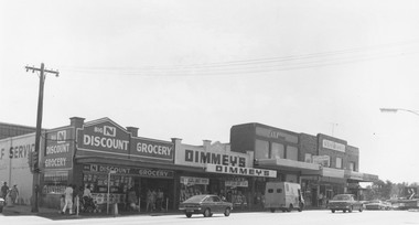
Photograph, Maroondah Highway Central, Ringwood. Shops on the north-east corner of Melbourne Street and Maroondah Highway, c.1970
Black and white photographShops in photograph are 'Big N Discount Grocery, Dimmey's, ANZ Bank, Sound and Camera'. Safeway roof can be seen in the distance.