Showing 15695 items
matching docuents-maps-france
-
 4th/19th Prince of Wales's Light Horse Regiment Unit History Room
Booklet, George Allen & Unwin, The Observers Handbook on Maps Charts and Projections, Sep 1941
... The Observers Handbook on Maps Charts and Projections...Maps ...Not significant to collection. Available for transfer to more appropriate collection.Booklet written for observers and pilots of the RAF and RAFVR to help them in preparing for their examinations.maps, charts, raf, observers -
Yendon History Group
Inventory, school, Unknown. Presume Education Department, Inventory of text books, maps and requisites, 1935 (estimated)
... Inventory of text books, maps and requisites ...medium level of local significance, as document gives good insight as to what equipment the school used for educational aids in the years 1935 to 1974.8 pages listing all books and educational material held by Yendon State SchoolStamped "STATE SCHOOL 719 YENDON". Many hand written entries on pages. Form number ST673yendon state school, education department, inventory, list -
National Vietnam Veterans Museum (NVVM)
Newspaper, Newspaper articles & maps donated by Mick Scrase
... Newspaper articles & maps donated by Mick Scrase ...Waiting to be catalogued.newspaper articles -
National Vietnam Veterans Museum (NVVM)
Newspaper, Newspaper articles & maps donated by Mick Scrase & Sgt. Koblitz
... Newspaper articles & maps donated by Mick Scrase & Sgt ...Waiting to be catalogued.newspaper articles -
National Vietnam Veterans Museum (NVVM)
Newspaper, Newspaper articles & maps donated by Mick Scrase
... Newspaper articles & maps donated by Mick Scrase. ...Waiting to be catalogued.newspaper articles -
Moorabbin Air Museum
Manual (item) - Maps & Charts - Dept of Civil Aviation
... Maps & Charts - Dept of Civil Aviation ... -
Moorabbin Air Museum
Book (item), William Alexander et al, The Observer's Handbook on Maps, Charts and Projections, January 1940
... The Observer's Handbook on Maps, Charts and Projections ... -
 Robin Boyd Foundation
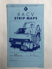
Map, RACV, Strip Maps Melbourne to Portsea
... Strip Maps Melbourne to Portsea ...walsh st library -
 Robin Boyd Foundation
Map, RACV, Strip Maps Melbourne to Portsea
... Strip Maps Melbourne to Portsea ...walsh st library -
 Robin Boyd Foundation
Map, RACV, Strip Maps Melbourne to Benalla
... Strip Maps Melbourne to Benalla ...walsh st library -
 Robin Boyd Foundation
Map, RACV, Strip Maps Melbourne to Ballarat
... Strip Maps Melbourne to Ballarat ...walsh st library -
 Robin Boyd Foundation
Pamphlet, RACV, Strip Maps Melbourne to Warrnambool
... Strip Maps Melbourne to Warrnambool ...walsh st library -
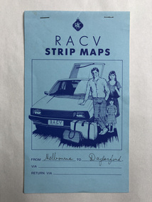
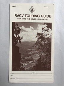
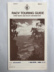 Robin Boyd Foundation
Pamphlet, RACV, Strip Maps Melbourne to Tidal River-Tarra Valley
... Strip Maps Melbourne to Tidal River-Tarra Valley ...walsh st library -
Moorabbin Air Museum
Souvenir (Item) - Ansett - Souvenir of Ansett & TAA inflight menus and old tickets AND Qantas route maps & menus
... tickets AND Qantas route maps & menus ... -
Moorabbin Air Museum
Souvenir (Item) - Ansett - flight souvenirs, maps, company manners, staff booklets, Boeing 727 Fan Jet, Marketing Booklets
... Ansett - flight souvenirs, maps, company manners, staff ... -
Moorabbin Air Museum
Pamphlet (Item) - London to Australia Air Race 1969 - photos, results, maps
... London to Australia Air Race 1969 - photos, results, maps ... -
Moorabbin Air Museum
Photograph (Item) - Photos & Maps of First Air Board - plus early Qantas/TAA postcards & crop-duster pics
... Photos & Maps of First Air Board - plus early Qantas/TAA ... -
Moorabbin Air Museum
Map (Item) - airport maps Includes a tribunal letter about avoiding night flying test, Maps of Australian airports
... Maps of Australian airports ... -
Moorabbin Air Museum
Manual (Item) - RAAF Advanced Navigation Course - Maps And Charts.TG-53 Volume 1
... RAAF Advanced Navigation Course - Maps And Charts.TG-53 ... -
Moorabbin Air Museum
Booklet (Item) - Instructions For The Preparation Of Weather Maps, With Tables Of The Specifications And Symbols
... Instructions For The Preparation Of Weather Maps, With ...Air Ministry - Meteorological Office -
Moorabbin Air Museum
Map (Item) - Maps of Northern Australia and New Guinea, AUS RNC 5 and 6 radio navigation maps
... AUS RNC 5 and 6 radio navigation maps ... -
Kew Historical Society Inc
Archive (series) - Subject File, Maps and plans, 1838-1998
... Maps and plans ...Reference, Research, InformationSecondary Values (KHS Imposed Order)Subject file containing a range of maps from different historical periods. Some have newspaper articles with background historical information. Some are maps produced by the MMBW, Members of Parliament, Melways, and hand-drawn maps locating where buildings, people and places were formerly in evidence. -
Stawell Historical Society Inc
Archive - CD/DVD, Historical Survey Maps of Ararat & Stawell - BMP's of all Images Scan of Book, 1/12/2005 12:00:00 AM
... Historical Survey Maps of Ararat & Stawell - BMP's of all ...stawell -
Friends of St Brigids Association
Leatherwood honey for Gall : A convict marries an immigrant Girl, Reddrop, Mary. 2000. Leatherwood Honey for Gall : A Convict Marries an Immigrant Girl. Blackburn, Vic. : PenFolk Publishing, 2000 viii, 210 p. : ill. (some col.), facsim., maps, ports.; 21 cm
... , 2000 viii, 210 p. : ill. (some col.), facsim., maps, ports ... -
Friends of St Brigids Association
Book - Letters from Irish Australia 1825-1929, O’Farrell, Patrick James. 1984. Letters from Irish Australia 1825-1929. Sydney : New South Wales University Press ; Belfast : Ulster Historical Foundation, 1984 244 p. : ill., maps ; 25 cm
... ; Belfast : Ulster Historical Foundation, 1984 244 p. : ill., maps ... -
Friends of St Brigids Association
Book - Croppies, Celts, and Catholics : The Irish in Australia, McConville, Chris. 1987. Croppies, Celts, and Catholics : The Irish in Australia. Caulfield East, Vic. : Edward Arnold, 1987 167 p. : ill., maps, ports. ; 25 cm
... , 1987 167 p. : ill., maps, ports. ; 25 cm. ... -
Friends of St Brigids Association
Book - A Shamrock beneath the Southern Cross : An History of the Shire of Belfast, Marriott, Pamela M. 1988. A Shamrock beneath the Southern Cross : An History of the Shire of Belfast.[Warrnambool, Vic.] : P. Marriott, 1988 184 p. : ill., maps, ports. ; 22 cm
... .] : P. Marriott, 1988 184 p. : ill., maps, ports. ; 22 cm. ... -
Friends of St Brigids Association
Book - Saving St Brigid’s, Lane, Regina. 2014. Saving St Brigid’s. Carlton South, Victoria : Bridin Books, 2014 .242 pages, 16 unnumbered pages of plates : illustrations (some colour), maps, portraits ; 24 cm
... plates : illustrations (some colour), maps, portraits ; 24 cm ... -
Friends of St Brigids Association
Book - An Atlas of Irish History, Edwards, Ruth Dudley. 1989. An Atlas of Irish History. London ; New York : Methuen, 1981 1 atlas (286 p.) : maps ; 24 cm
... . London ; New York : Methuen, 1981 1 atlas (286 p.) : maps ; 24 ... -
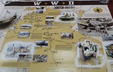 Ringwood RSL Sub-Branch
Work on paper - Commemorative WWII sites map Northern Territory, Maps
... Maps ...