Showing 1049 items
matching earth
-
 Federation University Historical Collection
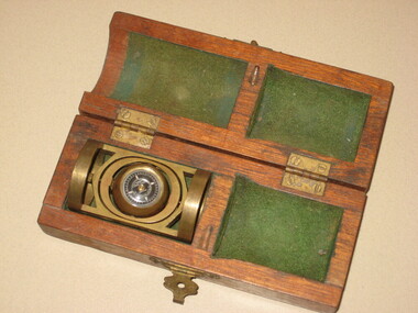
Instrument - Scientific Instrument, Pajari Instruments, Boxed Tropari
This item was most probably used at the Ballarat School of Mines. Pajari Instruments Ltd. grew from a partnership established in 1945 when the first EX-AX surveying instrument that provided accurate azimuth and inclination was made available to the diamond drilling industry. The partnership between Charles Trotter and George Pajari Sr. was known as Trotter-Pajari Instruments and the EX-AX Instrument was dubbed the "TROPARI" by the diamond drilling industry. Charles Trotter, a mechanical engineer, was also a marketing genius who developed substantial demand in Australia, Africa and South America in the 1940's and early 1950's. In fact the sales to each of these continents exceeded those to North America during those early years. Pajari is located in Orillia, Ontario, Canada and offer services and products that assist customers with their individual requirements. After the death of Charles Trotter in 1956, George Pajari Sr. with the assistance of his wife Hilda continued the business under the title of Pajari Instruments. George Sr. set most of the tenets that comprise our present Mission Statement. If it wasn't user friendly or if it had to have experts to operate it, that instrument design was doomed. If the customer wasn't getting good value in his opinion, manufacturing and repair procedures were examined to see where efficiency could be improved to cut costs without sacrificing Quality. George Pajari Jr and his wife Darlene assumed the reins of Pajari Instruments Ltd. in 1981 when George Sr. decided on semi-retirement. George Jr. brought the "client geologist's" perspective to the company. The company moved from Toronto to a 30 hectare (80 acre) site near Orillia shortly afterward. This site provided the high magnetic latitude earth field environment without magnetic pollution that is necessary for accurate compass setting. The park like setting of this location is a positive psychological benefit for our staff. George Sr. passed away in 2002 being preceded by Hilda only by 3 months, George Jr. continues at the helm of the company. With dedication from long term employees/contractors and third generation family members, Pajari Instruments Ltd. continues operations/new product development in Orillia. (http://www.pajari.com/about.html) Brass levelling compass in green velvet lined hinged timber box. Known as a Tropari - a single-shot, micro-mechanical borehole surveying instrument operated by a timing device. Borehole direction is measured from the earth's magnetic field. The Tropari provides both direction and inclination which can be used to define the attitude of the borehole at the survey depth. Regular surveys at intervals as the borehole progresses will allow a plot of the borehole to be drawn from the data. The Tropari is easy to use and maximizes profits by minimizing capital and operational costs. The Basic Survey Train Consists of: PDSI / Tropari Container, 6m (20 ft) Nonmagnetic Rods, Impact Foot, and Connector at Top. (http://www.pajari.com/tropari.html) A sticker on the lid of the hinged box states: "A.E. Parsons 107 Leicester St., Carlton 3053 Telephone 347 5844"scientific instrument, compass -
 Victorian Aboriginal Corporation for Languages
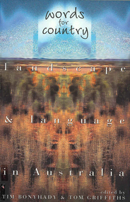
Book, Tim Bonyhady, Words for country : landscape &? language in Australia, 2002
Landscape and Language -- Lubra Creek -- The River Runs Backwards -- These Blarsted Hills -- Scarcely Any Water on Its Surface -- Everyone Who Has Ever Done A Tree Sit Always Says That The Tree Talks To You -- The Spirit of the Plains Kangaroo -- The Graveyard of a Century -- So Much for a Name -- Blackfellow Oven Roads -- The Ends of the Earth -- Natural Beauty, Man-Made -- Uluru -- The Outside Country -- It's Only Words.Mapslanguage and landscape, language essays, writing, storytelling -
 Melbourne Tram Museum
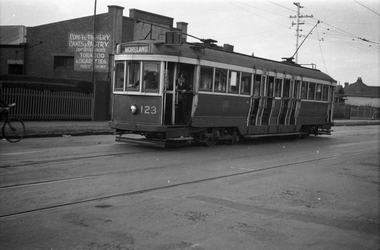
Negative, Wal Jack collection, 24/11/1941 12:00:00 AM
Black and white negative by Wal Jack of Maximum Traction N 123 (Moreland) in Nicholson St after running out of the Coburg Tram Depot. The shop in the background selling Confectionery etc is the Pause Cafe (Google Earth - 20-10-2020) Photo dated, 24/11/1941 in the Wal Jack album. See also Reg Item 5329 to 5332 for other photos featuring this tram.trams, tramways, n class, coburg depot, coburg, moreland, nicholson st, tram 123 -
 Wangaratta RSL Sub Branch
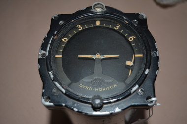
Instrument - Aircraft Horizon Indicator
Aircraft Gyro Horizon Indicator made by Sperry Gyroscope Co., in 1945. A gyro horizon or artificial horizon is an instrument used in an aircraft to inform the pilot of the orientation of the aircraft relative to Earth's horizon. It indicates pitch (fore and aft tilt) and bank (side to side tilt). Black painted cylindrical instrument with side cutout containing moving metal parts inserted with glass at one end. Indicator Gyro Horizon Manually Caged Electric Type H. 6B (1945)raaf, horizon indicator, gyro, 1945, sperry gyroscope, aircraft -
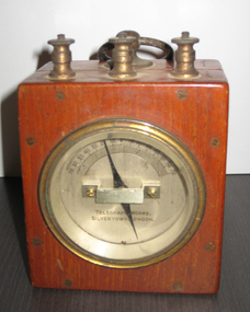 Federation University Historical Collection
Equipment - Galvonometer, 1930 (estimated)
Galvanometers are an instrument used for detecting and measuring electric current. They had a magnetic needle moved by the magnetic field produced by coils carrying the current to be measured, and the earth's field had to be taken into consideration. They were used to detect current in either direction in telegraphy systems, and to test equipment.Post Office Galvonometer. A hinged polished timber case with three brass terminals at the top, and ring (handle) and a dial (0 to 70) with an indictor needle. The opened box reveals wires leading to the terminals with two compartments covered in blue woven material (possibly silk).telegraph works, galvonometer, scientific instruments -
 The Ed Muirhead Physics Museum
Post Office Box
Assembled wood, bakelite and metal (screwed). Metal plate top screwed onto wooden box base, 15 black dials 3.0cm in height. Brass electrical connectors, brass plugs with Bakelite tops. Surface finish: machined. Inscribed on top face along the back edge: “T.E.P.L MELBOURNE [an arrow pointing upwards] 240 1941” Inscribed on top face along the front edge: “EUREKA, BRITISH STANDARD OHMS” Also instructive labels inscribed on top face: “POSITIVE POLE/LINE OR EARTH” “LINE AND GALVANOMETER” “GALVANOMETER” “NEGATIVE POLE AT 15.5OCENT” -
 Bendigo Historical Society Inc.
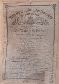
Document - ROYAL HUMANE SOCIETY CERTIFICATE FOR MINE RESCUE - CHARLES P. ROWE, 1888
Parchment certificate, enclosed in laminate on board. Issued to Charles P. Rowe Mine, Manager, New Chum Rly Mine in endeavouring to rescue Thos. Duggas and rescuing J. Wilson and J. Herron from being killed by a full of earth at Shenandoah Mine, Sandhurst 8th. August 1888. ( bronze medal also awarded ) On bottom of board ' above certificate is just one of many certificates and medals awarded to brave miners on the Bendigo Goldfields'Royal Humane Societytopic, mining, mine rescue -
 Bendigo Historical Society Inc.
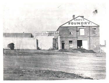
Photograph - WES HARRY COLLECTION: GRIPES FOUNDRY, 1860's
Photograph of a two storied brick factory with the words ' Gripes Foundry' painted below the gable. To the left of this building is a wide gateway and a single story wooden building with an iron roof. Above the gateway there is a large sign with ' Gripes Timber yard Iron &c on sale ' painted twice. There are two workmen standing in the doorway of the foundry and a large pile of earth in front of them. A picket fence can be seen running off to the right of the foundry Building.Batchelderbuildings, commercial, gripes foundry, gripes foundry, gripes timber yard, batchelder -
 Kew Historical Society Inc
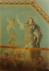
Photograph - Ceiling fresco, Ballroom, ‘Southesk’, Cotham Road, Stewart West, 1970
Colour enlargement of a photograph (slide) of Southesk (formerly Ordsall) in Cotham Road, Kew (demolished 1970).The ceilings of and architraves of Ordsall were painted by artists employed by the decorating company, Cullis Hill & Co. The frescos, of which fragments survive, were some of the most important murals used as elements of interior decoration in Melbourne during the Boom Period of the 1880s. These photographs were taken immediately prior to the demolition of the house, and are the best examples of the murals.The most significant decorative aspects of Southesk (formerly ‘Ordsall’) were the murals in the front two rooms. An article in the Melbourne Argus in 1882 records that Mr Vandenbrandt and Signor Rizzi created these under the supervision of Cullis Hill. This fresco from the ceiling of the ballroom is believed to depict one of the ‘boldly drawn four great geographical divisions of the Earth’. The crowned woman, believed to represent Europe, stands aloft in a chariot drawn by cherubs holding garlands of flowers.david carnegie, john halfey, southesk - cotham road - kew (vic), ordsall - cotham road - kew (vic) -
The Ed Muirhead Physics Museum
Post Office Box (Eureka)
Assembled, moulded. Coated. Accessories: dials. Surface finish: polished. Inscribed on upper face along back edge: “T.E.P.L. MELBOURNE [arrow] 551 1941” Inscribed on upper face along front edge: “EUREKA BRITISH STANDARD OHMS” Labels Inscribed on upper face: “POSTIVE POLE/LINE OR EARTH” “LINE AND/GALVANOMETER” “GALVANOMETER” “NEGATIVE POLE/AT 15.5oCENT” Underside written in pen: “ROBINSON & STUMBLES” -
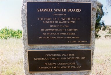 Stawell Historical Society Inc
Photograph, Plaques at "Moray" 1984 -- Coloured
Coloured Photo - Plaques at "Moray" 1984Stawell plaques on a square stone.Stawell Water Board unveiled by The Hon. D. R. White M.L.C. Minister of Water Supply on July 4th, 1984 To Commemorate the Addition of the Moray Water Reserve To the Board's Water Supply System E.C. Lewis - Chairman Consulting Engineers Gutteridge Haskins and Davey Pty. Ltd. Principal Contractors Hamilton Earth Movers Pty. Ltd.grampians water supply -
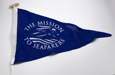 Mission to Seafarers Victoria
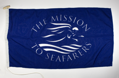
Flag - Pennant, The Mission to Seafarers, 20th C
Pennant displaying the flying angel motif without the Bible. The Mission adopted, as its symbol, a flying angel inspired by a verse from the Book of Revelation (14:60) “Then I saw a flying angel in mid-heaven, with an eternal gospel to proclaim to those on earth, to every nation and tribe, language and people”From the personal Collection of Mrs Pat Dann a former member of the Central MtSV and later with her husband Captain Keith Dann supported and founded the Hastings branch of the Mission to Seamen in the late 20th C. Mid-blue polyester fabric triangular Mission to Seafarers (with flying angel motif in white) pennant, with synthetic mounting rope.The Mission to Seafarers in whitepennant, flying angel, mission to seafarers -
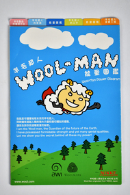 National Wool Museum
Booklet - Wool Man, NIKKE Group, c.2009
Eight page double sided multi-coloured fold out paper brochure featuring text and graphics. Text is in both Japanese and English languages.Front: WOOL-MAN / Wool-Man Power Diagram / I am the Wool-man, the Guardian of the future of the Earth, / I have possessed formidable strength and yet many genial qualities. / Let me show you the secret behind all these my power! / awi / WOOLMARK / NIKKE / Wool-Man originated fron NIKKE, Japan / www.wool.comwool-man, japan, wool, australia, nikke, australian wool innovation, woolmark -
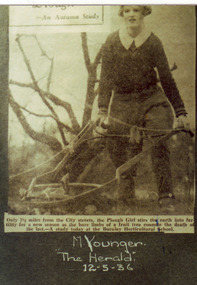 University of Melbourne, Burnley Campus Archives
Photograph - Colour print, The Herald, An Autumn Study, 1936
Photograph made by A.P. Winzenried as possible illustrations in, "Green Grows Our Garden." Colour prints. Copy of 2 newspaper articles made by A.P. Winzenried. 1. Top, "- An Autumn Study. Only 3⅟₂ miles from the City streets, the Plough Girl stirs the earth into fertility for a new season as the bare limbs of a fruit tree connote the death of the last - A study today at the Burnley Horticultural School." Female student using a horsedrawn plough in the Orchard. 2. A female student holding a bull wearing a head stall and a rope attached to a ring in its nose.Handwritten, "M. Younger. "The Herald." 12-5-36. Bottom, handwritten, "J. Wakeford & Vida's Boy. "The Herald." 12-5-36."a.p. winzenried, green grows our garden, plough, female students, fruit trees, j. wakeford, m. younger, students working outside, horse-drawn plough, bull, orchard, vida's boy -
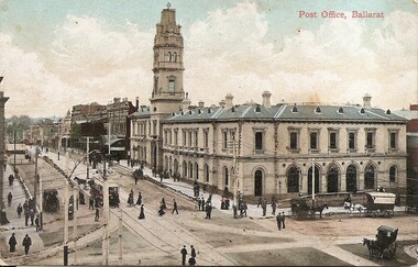 Ballarat Tramway Museum
Postcard, ESCo tram north bound in Lydiard St North
Yields information about the corner of Sturt St and Lydiard St soon after the Ballarat Electric Tramway opened.Digital Image of and ESCo tram north bound in Lydiard St North, at the intersection with Sturt St. Shows the Ballarat Post Office and other buildings in Lydiard St. Note the centre poles the new tram tracks. Photo taken soon after opening as the destination sign is on the dash panel. There are a number of lines of dark brown piles of earth? Work still being undertaken. Titled "Post Office Ballarat". From the Facebook group of old time photographs of yesterday.trams, tramways, sturt st, lydiard st north, esco, postcards -
 Bendigo Historical Society Inc.
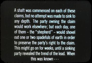
Slide - DIGGERS & MINING. GETTING THE GOLD, c1850s
Diggers & Mining. Getting the Gold. Slide: A shaft was commenced on each of these claims, but no attempt was made to sink to any depth. The party owning the claim would work elsewhere; but each, day, one of them - the ''shepherd'' - would shovel out one or two spadefuls of earth in order to preserve the party's right to the claim. This might go on for weeks, until a sinking party revealed the trend of the lead. When this was known . . . Markings: 53 994.LIF:4. Used as a teaching aid.hanimounteducation, tertiary, goldfields -
 Wodonga & District Historical Society Inc
Album - Hume Reservoir Australia Album - Plans and Progress Photos - River Murray Water Scheme, Department of Public Works, N.S.W, 1927
This set of photos is from a leather bound album bearing the inscription "HUME RESERVOIR AUSTRALIA" plus 'The Rt. Hon. L. C. M. S. Amery, P. C., M .P.' all inscribed in gold. It was presented to The Rt. Hon. L. C. M. S. Amery, P. C., M. P, Secretary of State for Dominion Affairs on the occasion of his visit to the Hume Reservoir on 2nd November 1927. This album is of local and national significance as it documents the planning and development of the Hume Reservoir up to 1927. It was the largest water reservoir in the British Empire. The album records the pioneering engineering work that went into its construction.1. Locality Plan and Plan of Dam. The dam is about ten miles by road upstream from Albury and about three-quarters of a mile below the confluence of the Mitta Mitta River and the Murray River. Its main features consist of a concrete portion across the bed of the river with earth embankment at both ends. The foundations throughout are on hard granite, found at an average depth of about 40 feet below the surface, the centre line being located to take advantage of the most favourable rock levels.Heading on page "WORKS UNDER RIVER MURRAY WATERS AGREEMENT/HUME RESERVOIR" Beneath top diagram "FIG. 1. ELEVATION" Beneath second diagram "FIG. 2. PLAN" On map "LOCALITY PLAN"hume reservoir australia, river murray waters scheme, hume weir diagrams, hume weir location -
 Ballarat Diocesan Historical Commission
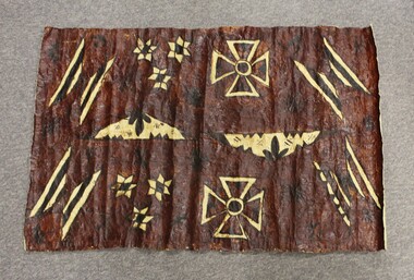
Tapa, Fijian Tapa, c. 1980
This Tapa cloth was presented to the Bishop of Ballarat as head of the Oceanic Bishops' gathering in the 1980s. The Tapa or bark cloth is prepared from the bark of a tree, beaten flat and glued with a native plant. It is then printed with earth dyes and sap from a Koka or candlenut tree. The design is printed by hand and the cloth used, in this case for ceremonial and presentation purposes.tapa, oceania bishops, fiji -
 Eltham District Historical Society Inc
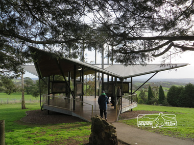
Photograph, Liz Pidgeon, Moor-Rul Viewing Platform, 10 August 2016
The Moor-Rul Viewing Platform, part of the Kangaroo Ground War Memorial Park opened in April 2007. Eight double-sided interpretation panels on the Moor-rul viewing platform highlight the area's Aboriginal and European history of the area and also details of local geology, flora and fauna. These panels feature high quality graphic design and professionally written text. The subjects covered are: ''Womin Je Ka" Welcome The Kulin Nation Singing, Dancing, Ceremony, Celebration This Country, My Home The Highland Taken Auld Lang Syne "Same Land Different Views" Working the Land Food from the Earth or "Earth's Harvest" Lest We Forget, "And with the going down of the Sun .... (3 panels) This Black Earth Those other indigenous inhabitants - Kangaroo Ground's Wildlife Silent Witnesses - Kangaroo Ground's White Manna Gums Belonging A Place of Reverence and A Tower of Strength Souce: EDHS Newsletter No 173 March 2007. As part of a program to acknowledge the Anzac Centenary Nillumbik Shire Council partnered with Yarra Plenty Regional Library to provide a bus tour with commentary of local sites of significance: Shire of Nillumbik World War One Memorials tour, 10 August 2016. These included Eltham township, the Shire of Eltham War Memorial at Kangaroo Ground, Christmas Hills war memorial, Hurstbridge memorial recreation park and finshed at Eltham Library to view the Writing the War exhibtion at Eltham Library Community Gallery.Born Digitalshire of nillumbik, moor-rul viewing platform, kangaroo ground, memorial park -
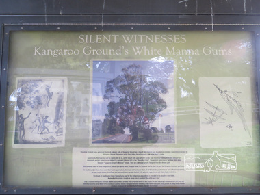 Eltham District Historical Society Inc
Photograph, Liz Pidgeon, Moor-Rul Viewing Platform Panel: Silent Witnesses Kangarooo Ground's White Manna Gums, 10 August 2016
The Moor-Rul Viewing Platform, part of the Kangaroo Ground War Memorial Park opened in April 2007. Eight double-sided interpretation panels on the Moor-rul viewing platform highlight the area's Aboriginal and European history of the area and also details of local geology, flora and fauna. These panels feature high quality graphic design and professionally written text. The subjects covered are: ''Womin Je Ka" Welcome The Kulin Nation Singing, Dancing, Ceremony, Celebration This Country, My Home The Highland Taken Auld Lang Syne "Same Land Different Views" Working the Land Food from the Earth or "Earth's Harvest" Lest We Forget, "And with the going down of the Sun .... (3 panels) This Black Earth Those other indigenous inhabitants - Kangaroo Ground's Wildlife Silent Witnesses - Kangaroo Ground's White Manna Gums Belonging A Place of Reverence and A Tower of Strength Souce: EDHS Newsletter No 173 March 2007. As part of a program to acknowledge the Anzac Centenary Nillumbik Shire Council partnered with Yarra Plenty Regional Library to provide a bus tour with commentary of local sites of significance: Shire of Nillumbik World War One Memorials tour, 10 August 2016. These included Eltham township, the Shire of Eltham War Memorial at Kangaroo Ground, Christmas Hills war memorial, Hurstbridge memorial recreation park and finshed at Eltham Library to view the Writing the War exhibtion at Eltham Library Community Gallery. Born Digitalshire of nillumbik, moor-rul viewing platform, kangaroo ground, manna gum, display panel -
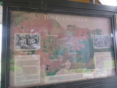 Eltham District Historical Society Inc
Photograph, Liz Pidgeon, Moor-Rul Viewing Platform Panel: The Kulin Nation, 10 August 2016
The Moor-Rul Viewing Platform, part of the Kangaroo Ground War Memorial Park opened in April 2007. Eight double-sided interpretation panels on the Moor-rul viewing platform highlight the area's Aboriginal and European history of the area and also details of local geology, flora and fauna. These panels feature high quality graphic design and professionally written text. The subjects covered are: ''Womin Je Ka" Welcome The Kulin Nation Singing, Dancing, Ceremony, Celebration This Country, My Home The Highland Taken Auld Lang Syne "Same Land Different Views" Working the Land Food from the Earth or "Earth's Harvest" Lest We Forget, "And with the going down of the Sun .... (3 panels) This Black Earth Those other indigenous inhabitants - Kangaroo Ground's Wildlife Silent Witnesses - Kangaroo Ground's White Manna Gums Belonging A Place of Reverence and A Tower of Strength Souce: EDHS Newsletter No 173 March 2007. As part of a program to acknowledge the Anzac Centenary Nillumbik Shire Council partnered with Yarra Plenty Regional Library to provide a bus tour with commentary of local sites of significance: Shire of Nillumbik World War One Memorials tour, 10 August 2016. These included Eltham township, the Shire of Eltham War Memorial at Kangaroo Ground, Christmas Hills war memorial, Hurstbridge memorial recreation park and finshed at Eltham Library to view the Writing the War exhibtion at Eltham Library Community Gallery. Born Digitalshire of nillumbik, interpretative signage, interpetation panel, indigenous history, moor-rul viewing platform, kangaroo ground -
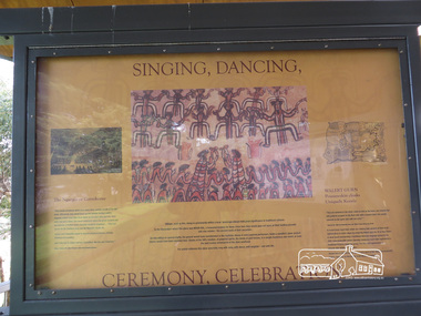 Eltham District Historical Society Inc
Photograph, Liz Pidgeon, Moor-Rul Viewing Platform Panel: Singing, Dancing, Ceremony, Celebrations, 10 August 2016
The Moor-Rul Viewing Platform, part of the Kangaroo Ground War Memorial Park opened in April 2007. Eight double-sided interpretation panels on the Moor-rul viewing platform highlight the area's Aboriginal and European history of the area and also details of local geology, flora and fauna. These panels feature high quality graphic design and professionally written text. The subjects covered are: ''Womin Je Ka" Welcome The Kulin Nation Singing, Dancing, Ceremony, Celebration This Country, My Home The Highland Taken Auld Lang Syne "Same Land Different Views" Working the Land Food from the Earth or "Earth's Harvest" Lest We Forget, "And with the going down of the Sun .... (3 panels) This Black Earth Those other indigenous inhabitants - Kangaroo Ground's Wildlife Silent Witnesses - Kangaroo Ground's White Manna Gums Belonging A Place of Reverence and A Tower of Strength Souce: EDHS Newsletter No 173 March 2007. As part of a program to acknowledge the Anzac Centenary Nillumbik Shire Council partnered with Yarra Plenty Regional Library to provide a bus tour with commentary of local sites of significance: Shire of Nillumbik World War One Memorials tour, 10 August 2016. These included Eltham township, the Shire of Eltham War Memorial at Kangaroo Ground, Christmas Hills war memorial, Hurstbridge memorial recreation park and finshed at Eltham Library to view the Writing the War exhibtion at Eltham Library Community Gallery.Born Digitalwar memorials, shire of nillumbik, indigenous history, kangaroo ground, moor-rul viewing platform, interpretative signage, interpretation panel, display panel -
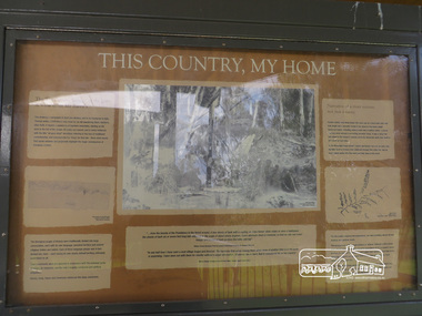 Eltham District Historical Society Inc
Photograph, Moor-Rul Viewing Platform Panel: This Country, My Home, 10 August 2016
The Moor-Rul Viewing Platform, part of the Kangaroo Ground War Memorial Park opened in April 2007. Eight double-sided interpretation panels on the Moor-rul viewing platform highlight the area's Aboriginal and European history of the area and also details of local geology, flora and fauna. These panels feature high quality graphic design and professionally written text. The subjects covered are: ''Womin Je Ka" Welcome The Kulin Nation Singing, Dancing, Ceremony, Celebration This Country, My Home The Highland Taken Auld Lang Syne "Same Land Different Views" Working the Land Food from the Earth or "Earth's Harvest" Lest We Forget, "And with the going down of the Sun .... (3 panels) This Black Earth Those other indigenous inhabitants - Kangaroo Ground's Wildlife Silent Witnesses - Kangaroo Ground's White Manna Gums Belonging A Place of Reverence and A Tower of Strength Souce: EDHS Newsletter No 173 March 2007. As part of a program to acknowledge the Anzac Centenary Nillumbik Shire Council partnered with Yarra Plenty Regional Library to provide a bus tour with commentary of local sites of significance: Shire of Nillumbik World War One Memorials tour, 10 August 2016. These included Eltham township, the Shire of Eltham War Memorial at Kangaroo Ground, Christmas Hills war memorial, Hurstbridge memorial recreation park and finshed at Eltham Library to view the Writing the War exhibtion at Eltham Library Community Gallery. Born Digitalwar memorials, shire of nillumbik, kangaroo ground, moor-rul viewing platform, interpretative signage, interpretation panel, display panel -
 Eltham District Historical Society Inc
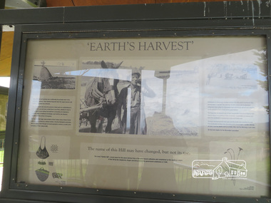
Photograph, Liz Pidgeon, Moor-Rul Viewing Platform Panel: 'Earth's Harvest', 10 August 2016
The Moor-Rul Viewing Platform, part of the Kangaroo Ground War Memorial Park opened in April 2007. Eight double-sided interpretation panels on the Moor-rul viewing platform highlight the area's Aboriginal and European history of the area and also details of local geology, flora and fauna. These panels feature high quality graphic design and professionally written text. The subjects covered are: ''Womin Je Ka" Welcome The Kulin Nation Singing, Dancing, Ceremony, Celebration This Country, My Home The Highland Taken Auld Lang Syne "Same Land Different Views" Working the Land Food from the Earth or "Earth's Harvest" Lest We Forget, "And with the going down of the Sun .... (3 panels) This Black Earth Those other indigenous inhabitants - Kangaroo Ground's Wildlife Silent Witnesses - Kangaroo Ground's White Manna Gums Belonging A Place of Reverence and A Tower of Strength Souce: EDHS Newsletter No 173 March 2007. As part of a program to acknowledge the Anzac Centenary Nillumbik Shire Council partnered with Yarra Plenty Regional Library to provide a bus tour with commentary of local sites of significance: Shire of Nillumbik World War One Memorials tour, 10 August 2016. These included Eltham township, the Shire of Eltham War Memorial at Kangaroo Ground, Christmas Hills war memorial, Hurstbridge memorial recreation park and finshed at Eltham Library to view the Writing the War exhibtion at Eltham Library Community Gallery. Born Digitalwar memorials, shire of nillumbik, kangaroo ground, moor-rul viewing platform, interpretative signage, interpretation panel -
 Eltham District Historical Society Inc
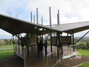
Photograph, Liz Pidgeon, Moor-Rul Viewing Platform, 10 August 2016
The Moor-Rul Viewing Platform, part of the Kangaroo Ground War Memorial Park opened in April 2007. Eight double-sided interpretation panels on the Moor-rul viewing platform highlight the area's Aboriginal and European history of the area and also details of local geology, flora and fauna. These panels feature high quality graphic design and professionally written text. The subjects covered are: ''Womin Je Ka" Welcome The Kulin Nation Singing, Dancing, Ceremony, Celebration This Country, My Home The Highland Taken Auld Lang Syne "Same Land Different Views" Working the Land Food from the Earth or "Earth's Harvest" Lest We Forget, "And with the going down of the Sun .... (3 panels) This Black Earth Those other indigenous inhabitants - Kangaroo Ground's Wildlife Silent Witnesses - Kangaroo Ground's White Manna Gums Belonging A Place of Reverence and A Tower of Strength Souce: EDHS Newsletter No 173 March 2007. As part of a program to acknowledge the Anzac Centenary Nillumbik Shire Council partnered with Yarra Plenty Regional Library to provide a bus tour with commentary of local sites of significance: Shire of Nillumbik World War One Memorials tour, 10 August 2016. These included Eltham township, the Shire of Eltham War Memorial at Kangaroo Ground, Christmas Hills war memorial, Hurstbridge memorial recreation park and finshed at Eltham Library to view the Writing the War exhibtion at Eltham Library Community Gallery.Born Digitalshire of nillumbik, moor-rul viewing platform, kangaroo ground -
 Bendigo Historical Society Inc.
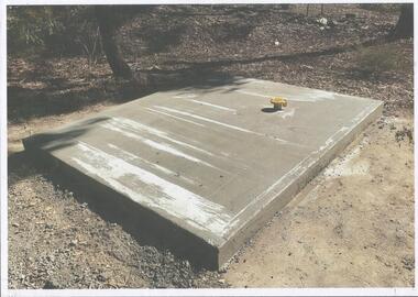
Photograph - Kangaroo Flat Gold Mine Collection: Catherine Reef South shaft
Kralcopic Pty Ltd, was a subsidiary of Bendigo-based company GBM Gold and had previously held mining licences around Bendigo, which incorporated sites including Kangaroo Flat, New Moon, Eaglehawk and the associated Woodvale Evaporation Ponds Complex. In August 2019, the Earth Resources Regulator decided not to renew Kralcopic’s three mining licences, due to the company’s inability to provide surety that it could finance its mining activities and site rehabilitation obligations. In October 2020, the company filed legal proceedings in the Supreme Court challenging the decision not to renew these licences. The Supreme Court later upheld the regulator’s decision not to renew the licences. On 23 April 2021, the Federal Court of Australia appointed KPMG as Kralcopic’s liquidators. On 14 May 2021, the liquidator lodged papers with the Australian Securities and Investment Commission (ASIC) to disclaim Kralcopic’s freehold land at Woodvale and parcels of land around the company’s former Bendigo sites, with the land to subsequently become Crown land. The Earth Resources Regulator has put a statutory exemption in place to preclude new mining licence applications on the sites while we undertake rehabilitation. The exemption also provides an opportunity for government to consider future uses of the sites in consultation with the City of Greater Bendigo and the local community. The Earth Resources Regulator holds rehabilitation bonds totalling $5.9 million, which it will use to rehabilitate the former sites.Colour photocopy of original photo. Image shows Catherine Reef South shaft with rectangular concrete capping. Ventilation pipe in concrete capping. On back in pencil: Catherine Reef South shaft with cap - Kralcopicwestern mining corporation, goldmining, capping, shaft, mining regulations, williams united shaft, kralcopic -
 Mission to Seafarers Victoria
Flag, The Mission to Seafarers, 21st Century
Flag displaying the flying angel motif. The highly stylised motif gives a clue as to approx date of manufacture. The Mission adopted, as its symbol, a flying angel inspired by a verse from the Book of Revelation (14:60) “Then I saw a flying angel in mid-heaven, with an eternal gospel to proclaim to those on earth, to every nation and tribe, language and people”.From the personal Collection of Mrs Pat Dann a former member of the Central MtSV and later with her husband Captain Keith Dann supported and founded the Hastings branch of the Mission to Seamen in the late 20th C. Large rectangular Mid-blue polyester fabric Mission to Seafarers (with flying angel motif in white) flag, with synthetic mounting rope.flag, flying angel -
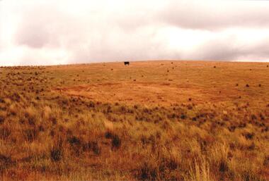 Hume City Civic Collection
Photograph, c late 1990s
The series of 9 photographs were taken to be included in a study of archaeological sites and Aboriginal rings in the Sunbury area. Five earth rings which are thought to be associated with male initiation ceremonies have been identified in Sunbury. Only 3 others have been found in the rest of Victoria. Despite rapid development in the area, those sites are protected heritage sites.A coloured photograph of an Aboriginal Ring which is a proclaimed sacred site on an open grassy hillside. A black cow is standing in the distance.aboriginal culture, aboriginal rings, sacred sites, george evans collection -
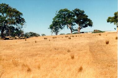 Hume City Civic Collection
Photograph, c late 1990s
The series of 9 photographs were taken to be included in a study of archaeological sites and Aboriginal rings in the Sunbury area. Five earth rings which are thought to be associated with male initiation ceremonies have been identified in Sunbury. Only 3 others have been found in the rest of Victoria. Despite rapid development in the area, those sites are protected heritage sites.A coloured photograph of an open hillside which is a sacred site. Gum trees and grassy tufts are dotted across the hillside.aboriginal culture, aboriginal rings, sacred sites, george evans collection -
 Hume City Civic Collection
Photograph, c late 1990s
The series of 9 photographs were taken to be included in a study of archaeological sites and Aboriginal rings in the Sunbury area. Five earth rings which are thought to be associated with male initiation ceremonies have been identified in Sunbury. Only 3 others have been found in the rest of Victoria. Despite rapid development in the area, those sites are protected heritage sites.A view of the Aboriginal ring and sacred site and its close proximity to a proposed housing estate at Sherwood near Racecourse Road.aboriginal culture, aboriginal rings, sacred sites, george evans collection