Showing 298 items
matching greensborough bridge
-
 Eltham District Historical Society Inc
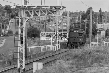
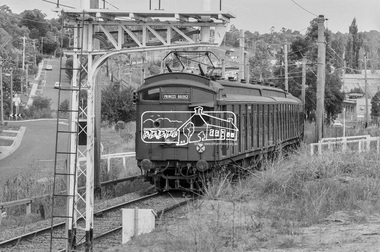
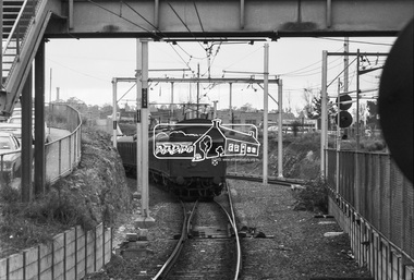
Photograph, George Coop, Princes Bridge bound Tait (Red Rattler) train approaching Greensborough Station, March 1980, 1980
Looking southeast along Para Road. Sherbourne road overpass in distance. Railway Parade on left. Briar Hill industrial area on right.Digital TIFF file Scan of 35mm Kodak Safety 5063 black and white transparencygreensborough railway station, industry, para road, railway parade, red rattler, sherbourne road, tait train -
 Eltham District Historical Society Inc
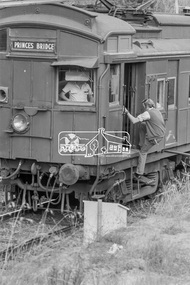
Photograph, George Coop, A Tait (Red Rattler) train departs Greensborough Railway Station bound for Princes Bridge, c. October 1982, 1982
Digital TIFF file Scan of 35mm Ilford FP4 black and white transparencygreensborough railway station, hurstbridge line, red rattler, tait train -
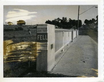 City of Whittlesea
Photograph - Photographs - Bridges, Photograph - Bridge - Bundoora, 1967
Bridge over Darebin Creek, Settlement Road Bundoora. Looking west towards Thomastown, April 1967. Bridge post includes Australian Labor Party election poster for Greensborough Electorate. Bob Fell was the ALP candidate at the 1967 state election which he lost.Photographs, black and white print on paper. Bridge over Darebin Creek, Settlement Road Bundoora 1967. -
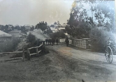 Greensborough Historical Society
Photograph - Photograph (Framed), Herding stock over blue stone bridge looking up Main Street Greensborough
Heading stock over Blue stone bridge looking up Main Street Greensborough. In this photograph, Greensborough was a country town. Note the unmade road leading up to the bridge.From the John Mackey collection. This item was displayed at the offices of Ryan, Mackey and Kelly, solicitors, Main Street Greensborough.Timber-framed photograph of herding stock over blue stone bridge looking up Main Street Greensborough, black and white.greensborough, john mackey, blue stone bridge, marble hall -
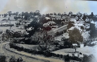 Greensborough Historical Society
Photograph - Photograph (Framed), Greensborough from Diamond Creek Road
Greensborough from Diamond Creek Road, includes a view of lower Main Street and lower parkFrom the John Mackey collection. this item was displayed at the offices of Ryan, Mackey and Kelly, solicitors, Main Street Greensborough.Timber-framed photograph of view of Greensborough from Diamond Creek Road, black and white.greensborough, john mackey, blue stone bridge, marble hall -
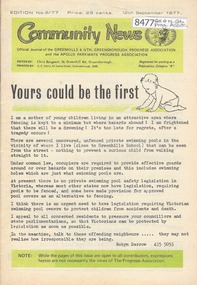 Greensborough Historical Society
Newsletter, Greenhills and North Greensborough Progress Association, Community News: official journal of the Greenhills and Nth. Greensborough Progress Association and the Apollo Parkways Progress Association. 12th September, 1977. Edition No. 8/77, 12/09/1977
You could be the first [private swimming pool safety], Swimming pool safety debate, Market to market, In Diamond Valley, we commission our commissioner - Brian Waters, This and that, Children's Week, From the Council Chamber, Nillumbik Historical Society: history at Apollo Parkways - The Siphon Bridge on the Plenty River, Scout news, Diamond Valley Arts Society. A digital copy of this Newsletter is available from Greensborough Historical Society.Newsletter, 24 p., illus.greenhills and north greensborough progress association, greenhills, apollo parkways progress association, apollo parkways -
 Eltham District Historical Society Inc
Photograph - Digital Photograph, Alan King, Maroondah Aqueduct Siphon Bridge over the Plenty River, 26 January 2008
Opened in 1891, the bridge formed part of the Maroondah Aqueduct carrying water from Watts River near Healesville to the reservoir at Preston where it joined Melbourne's metropolitan water system. Covered under Heritage Overlay, Nillumbik Planning Scheme. Published: Nillumbik Now and Then / Marguerite Marshall 2008; photographs Alan King with Marguerite Marshall.; p99 Built to supply thirsty Melbourne in the late 19th century, the siphon bridge spanning the Plenty River off Leischa Court, Greensborough, was part of an engineering masterpiece. Opened in 1891, the bridge formed part of the Maroondah Aqueduct carrying water from the Watts River near Healesville to the reservoir at Preston where it joined the metropolitan distribution system. A major link in Melbourne’s water supply, it also had a huge impact on communities, which mushroomed along its route. Named after the Aboriginal word for the area around the Maroondah Reservoir, the Maroondah Aqueduct was fully operational until the 1970s. Since the 1980s the land along parts of the aqueduct have been used for walking and bicycle riding, shaded in places by Monterey Pine trees planted to stabilise the surrounding ground. From 1857 the Yan Yean Reservoir supplied Melbourne’s water but the growing city needed additional catchments.1 In 1886 work began on a weir on the Watts River to enable the aqueduct to carry most of the river water 41 miles (66km) to Melbourne. The aqueduct, built by the Board of Works, is the oldest remaining aqueduct near Melbourne and was probably the first built with concrete.2 Although the aqueduct is now only used between the Maroondah and Sugarloaf Reservoirs, it can still be traced across the Shire. It extends from the Maroondah Reservoir through Christmas Hills, Kangaroo Ground, Research, Eltham, St Helena and then previously wound west through Greensborough to Reservoir.3 Built by horse and manpower the aqueduct gravity fed 25 million gallons (113.6ML) of water a day to Melbourne along a gradient of one foot to the mile. It included 25 miles (41km) of open concrete and brick channel, six miles (10km) of tunnels, and nine miles (15km) of 14 inverted siphons of riveted wrought-iron across creeks. Bricks for the aqueduct were made from clay found near the sites and remains of several kilns can still be found between Kangaroo Ground and Christmas Hills. Building the aqueduct transformed local communities. An abattoir was established at Christmas Hills. Grog shanties and labourers’ camps sprang up and local courts dealt with cases of ‘petty pilfering and boisterous behaviour’.4 The Kangaroo Ground school population jumped to 91, crammed into a room with one teacher. Miners who built the tunnels camped just north of Churinga in Greensborough – then called Tunnel Hill Camp – and adjacent to the Evelyn Arms Hotel. The miners’ high spirits were sometimes quenched in horse troughs or by a ‘welt under the ear and kick on the behind’ as the local constable calmed them down rather than lock them up.5 But the growing city of Melbourne needed more water, so the O’Shannassy catchment, east of Warburton, was added to the system in 1914. In 1920 work began on the present concrete Maroondah Dam one mile (1.6km) from the weir on the Watts River. The aqueduct capacity was thus doubled to 50 million gallons (227ML) a day.6 Intense land development threatened to pollute the open water supply, so channel sections were replaced with large pipes. In the late 1960s a large water main was built from the tunnel outlet at Research and extended through St Helena and Greensborough, so this section of the aqueduct was taken out of use. Long sections of the unused open channels in Greensborough and Bundoora were destroyed, but the old channel in Research and Eltham North remained largely intact. In the 1970s, the Sugarloaf Reservoir was constructed, inundating 445 hectares of land in Christmas Hills. Sugarloaf was officially opened in 1980 and serves as a water storage and treatment plant supplying Melbourne. In the early 1980s pipes replaced the section from Sugarloaf Reservoir to the tunnel entrance at Kangaroo Ground. The Research-Kangaroo Ground tunnel operates as part of the pipeline system.This collection of almost 130 photos about places and people within the Shire of Nillumbik, an urban and rural municipality in Melbourne's north, contributes to an understanding of the history of the Shire. Published in 2008 immediately prior to the Black Saturday bushfires of February 7, 2009, it documents sites that were impacted, and in some cases destroyed by the fires. It includes photographs taken especially for the publication, creating a unique time capsule representing the Shire in the early 21st century. It remains the most recent comprehenesive publication devoted to the Shire's history connecting local residents to the past. nillumbik now and then (marshall-king) collection, maroondah aqueduct, pipe bridge, siphon bridge -
 Eltham District Historical Society Inc
Photograph - Digital Photograph, Alan King, Eltham Railway Trestle Bridge, 28 December 2007
Covered under National Trust of Australia (Victoria) State Significance and Heritage Overlay, Nillumbik Planning Scheme. Published: Nillumbik Now and Then / Marguerite Marshall 2008; photographs Alan King with Marguerite Marshall.; p103 The Eltham railway trestle bridge is the only one of its kind still regularly used in Melbourne’s metropolitan railway network. Opened in 1902, it is also one of Victoria’s very few timber rail bridges that still carries trains.1 The bridge is part of the railway line extension from Heidelberg - extended to Hurstbridge in 1912. This extension resulted in one of the greatest social changes experienced in Eltham Shire, as it considerably lessened its isolation attracting tourists, artists and suburban commuters particularly after World War Two.2 The bridge has been classified by the National Trust as historically, scientifically, aesthetically and socially significant at state level. But this has not always been recognised, and in 1977, locals fought to save it from destruction. The Victorian Railways proposed to replace the bridge with an earth embankment and large culverts to avoid maintenance problems and fire. This was rejected by the Eltham Council who protested that the bridge helped maintain the area’s rural character, historic link and beauty, as well as avoiding possible serious flooding on the flood plain if a culvert was blocked. The bridge stands as part of a National Trust classified landscape which includes the Alistair Knox Park, named after the local conservationist and architect who helped to make Eltham famous for its mud-brick houses. The landscape includes tall and spreading manna gums and candlebarks, and the historic Shillinglaw Cottage. Artist Walter Withers, one of the Heidelberg School of painters, painted the bridge early in the 20th century. The 38 span single-track railway bridge over creek and road has 34 timber-beam spans and four steel-joist spans, supported by four-pile timber piers and timber abutments. It has almost 200m of timber deck. All of the timbers have been replaced over the years, but the only change to the bridge’s character was the addition of pylons and wiring for electric trains in 1923. A petition for a railway to the shire was first made in 1883. A large deputation of local citizens to the Commissioner of Railways proposed a route passing through Alphington to midway between Greensborough and Eltham up the Diamond Creek valley towards Queenstown and Kinglake. As a result the Princes Bridge-Heidelberg Railway was opened in 1888. From 1888 locals demanded a railway extension. Kangaroo Ground farmers in particular, led by Shire Councillor and Member for Evelyn, Ewen Cameron, said it would assist local farmers and orchardists send their produce to the Melbourne market. In 1890, before the severe economic Depression, an extension of the line to Hurst’s Bridge (now Hurstbridge) was included in a new Railways Bill. The parliamentary delegations were regaled with a banquet at Hurst’s barn and entertained by the Diamond Creek Brass Band, but the extension was abandoned when the Depression struck in 1892-1893. The extension of the railway to Eltham, completed in 1902, was one of the few built in those hard times. That is why the Eltham timber-trestle railway bridge is a rare example of a broad-gauge rail bridge constructed between 1893 and 1910. At the opening, despite persistent drizzle, 300 children waving flags and banners were among the large crowd welcoming the first train, carrying official dignitaries, to Eltham. It had taken 24 years to bring the railway to Eltham. From then Eltham became a popular destination for outings. Mr Orford of Eltham recalled that after the railway came to Eltham ‘the craze for picnics on weekends and holidays began…. During the wattle season, wattle trains came to Eltham frequently. The visitors roamed the creek pulling great armfuls of wattle blossom to take back with them to Melbourne’.3 In 1926 the railway line was electrified as part of the metropolitan rail network. But the Victorian Railways decided not to complete the formerly planned Diamond Valley Railway to Queenstown (now St Andrews) and Kinglake.This collection of almost 130 photos about places and people within the Shire of Nillumbik, an urban and rural municipality in Melbourne's north, contributes to an understanding of the history of the Shire. Published in 2008 immediately prior to the Black Saturday bushfires of February 7, 2009, it documents sites that were impacted, and in some cases destroyed by the fires. It includes photographs taken especially for the publication, creating a unique time capsule representing the Shire in the early 21st century. It remains the most recent comprehenesive publication devoted to the Shire's history connecting local residents to the past. nillumbik now and then (marshall-king) collection, eltham railway trestle bridge, eltham trestle bridge -
 Eltham District Historical Society Inc
Document - Folder, Shallard family
Jack and Mary Emma Shallard and their three children, Bill, Joyce and Jack, moved to the Eltham area around 1912. Jack married Blanche Everard and lived in Montmorency and was active in community matters. Contents Photocopy page, October 1920, re Eltham, noting Joseph Bromley Shallard as a Councillor for Eltham. Photograph: Eltham Historical Society display at home of Joy and Bruce Ness 1987, Les Robertson, Jack Shallard, Blanche Shallard and Margorie North. Photograph: Eltham Historical Society float, Eltham Festival Parade 1988, Blanche Shallard, Opal Smith and Eileen Gibbon. Manuscript and typed notes, no date: Memories of Eltham and district by Jack Shallard Newspaper article: "Jack Shallard will be sadly missed", Diamond Valley News, 18 June 1991. Obituary of Jack Shallard. Letter Elizabeth Pidgeon to Eltham District Historical Society, 20 March 2001: Seeking information on Shallard family of Eltham, provides information on Roberts and Tinker families. Newspaper death notice for Blanche Shallard, The Age, 12 September 2002. Newspaper funeral notice for Blanche Shallard, The Age, 13 September 2002. Order of Service: Blanche Emily Shallard, St Faith's Anglican Church, Montmorency, 13 September 2002. Eulogies for Blanche Shallard by Jan Mullins, Kerry Knowles, and grandchildren of Blanche Shallard. Letter Sue Law to the Shallard family, 15 September 2002. Acknowledging contribution of Blanche Shallard to EDHS and seeking copies of eulogies. Newspaper article: "Community honours a favourite resident", Diamond Valley Leader, 20 November 2002. Obituary of Blanche Emily Shallard with photograph. Notes, undated, of Sue Law's recollections from Blanche Shallard. Newspaper advertisement: "63 and 65 Rattray Road, Montmorency", Diamond Valley News, no date. For sale 63 and 65 Rattray Road, Montmorency. Newspaper advertisement: "63 and 65 Rattray Road, Montmorency", Diamond Valley Leader, 12 March 2003. Auction 5 April of 63 and 65 Rattray Road, Montmorency.Newspaper clippings, A4 photocopies, etcjoseph shallard, mary emma shallard nee tinker, elizabeth ann tinker nee roberts, susan shallard nee roberts, james roberts, sarah roberts nee pope, joseph bromley shallard, william shallard, joseph tinker, jack vincent shallard, jocelyn shallard, christopher shallard, elsie shallard nee mills, meruka house sherbourne road, mary north, jack shallard, blanche shallard nee everard, bill everard, eltham primary school, melbourne high school, university of melbourne, holy trinity church of england kew, st margaret's church of england eltham, st faith's church of england montmorency, best hooper rintoul and shallard, diamond valley community hospital, blanche emily shallard nee everard, 63-65 rattray road montmorency, jan mullins, kerry knowles, joy neww, bruche ness, les robertson, marjorie north, eltham festical parade 1988, opal smith, eileen gibbon, joyce shallard, falkiner street eltham, bridge street eltham, karingal drive montmorency, sherbourne road montmorency, "kaweka" sherbourne road montmorency, greensborough road eltham, eltham state school, rechabites hill henry street eltham, eltham hotel, boy scouts troup eltham, eltham district cricket association, first world war memorial tltham, eltham railway station -
 Greensborough Historical Society
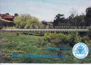
Booklet, The Shire of Diamond Valley Handbook 1982, 1982_
Guide to services provided by Shire of Diamond Valley. The Shire of Diamond Valley was a Local Government Area located about 20 kilometres northeast of Melbourne. The shire covered an area of 74.38 square kilometres and existed from 1964 until 1994. Cover illustration of aqueduct and bridge over Plenty River near Apollo Parkways estste.Annual guide to services in Shire of Diamond Valley32 pages, col illus., maps. 2 copiesshire of diamond valley, greensborough, handbooks -
 Greensborough Historical Society
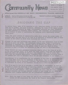
Newsletter, Greenhills and North Greensborough Progress Association, Community News: official journal of the Greenhills and North Greensborough Progress Association. 20th April, 1972. Edition No.2/72, 20/04/1972
This edition includes a report on the Progress Association's April 1972 meeting, President's report 1971-72, Bridging the gap, Facts about Lake Pedder, Yandell Reserve, Boys will the boys, Roads, The new sports complex: a view point. School and Kinder news, Local news, Diamond Valley Repertory. A digital copy of this Newsletter is available from Greensborough Historical Society.Newsletter, 18 p., illus. Printer's phone number written in red pen on cover.greenhills and north greensborough progress association, greenhills -
 Greensborough Historical Society
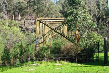
Photograph - Photograph - Digital Image, Marilyn Smith, Aqueduct crossing the Plenty River, Greensborough 2019, 02/07/2019
The aqueduct crossing the Plenty River, 2019, overgrown with vegetation. Originally part of the Maroondah Aqueduct pipeline, all that remains is the bridge that once carried the pipe over the Plenty River. This photograph was taken from the Plenty River Trail in Greensborough. 3 colour digital photographsplenty river trail, maroondah pipetrack, maroondah aqueduct, plenty river, graffiti -
 Eltham District Historical Society Inc
Photograph, Looking north across the Fitzsimons Lane Bridge over Yarra River between Eltham and Templestowe, c.1985, 1985c
Turnoff to Candlebark Park on right. The bridge over the Yarra River was initially opened September 22nd, 1961. Newspaper reports at the time of opening stated it linked Bolton Street, Eltham, with Fitzsimons Lane, Templestowe. In 1955 the Country Roads Board (CRB) produced survey plans that showed proposed land acquisition for the future bridge and road approaches. The 1955 plan shows that it was proposed to connect Fitzsimons Lane with Bolton Street in Eltham by a diagonal road across the river. The road connection would then continue along Bolton Street to Main Road. Prior to construction of the bridge the CRB modified the proposal significantly so that there was a new road parallel with Bolton Street and then curving to join Main Road at what was then its intersection with Old Eltham Road. This involved significantly more land acquisition and altered the pattern of land subdivision through this corridor. Initially the new road was just a single two-way carriageway as it would have required a significant widening of the cutting on the Shire of Eltham side of the river. The road was officially un-named but was known locally as the Eltham-Templestowe Road. The 1966 Melway street directory and other 1960s editions also listed the road as the Eltham-Templestowe Road. In December 1970, Eltham Shire Council, in pursuance of the provisions of the Local Government Act, named it Templestowe Road. The road was renamed Fitzsimons Lane around 1984 in conformity with the section south of the river. In 1991 a new bridge was built to the west of the original bridge. Fitzsimons Lane was widened to four traffic lanes although on the Eltham side this was done within the limits of the existing cutting. NEW BRIDGE STARTS THEM EXPLORING Without any fanfares, Country Roads Board workmen on Friday afternoon put the finishing touches to the approaches, removed the barricades, and let the traffic roll over the new Yarra bridge linking Bolton Street, Eltham, with Fitzsimons Lane, Templestowe. Over the week-end many “bridge watchers” who were making one of their periodic inspections of the progress on the new bridge found to their surprise that they could drive over it, so that people who had gone for a run out to Eltham suddenly found themselves wandering through Templestowe and Doncaster. By Monday the word of the bridge’s opening had got around sufficiently for many regular travellers to the city from Eltham and beyond to vary the monotony by going to town via Templestowe and Kew instead of through Heidelberg. They were surprised at the distances – about 3 ½ miles from Eltham to Templestowe, 6 miles from Eltham Shire hall to the Lower Heidelberg Road-Banksia Street intersection. NEW NEIGHBOURS For people on both sides of the river, the new bridge has turned distant friends into near neighbours. A Greensborough man on Sunday took 35 minutes to reach the home of a friend in East Doncaster, but the return trip over the new bridge took only 17 minutes. It will be some time yet before most people work out the possibilities in shorter and quicker trips form the north-eastern areas to the eastern and south-eastern suburbs. The coming of the warmer months will soon teach many, though the short cuts to Peninsular beaches and eastern suburban drive-ins. And before very long it is likely there will be a Tramways bus running from Templestowe to Eltham station. NEW BRIDGE STARTS THEM EXPLORING (1961, September 27). The Diamond Valley News (News clipping held in SEA_74-1_047) The previously un-named road between Main Road and Yarra River, Eltham South, east of Bolton Street was named Templestowe Road, December 15, 1970 NAMING OF STREETS AND ROADS. (1970, December 15). The Diamond Valley News (News clipping held in SEA_74-2_022)Colour photographinfrastructure, shire of eltham infrastructure, bridge, fitzsimons lane bridge, yarra river, candlebark park, red nose day -
 Eltham District Historical Society Inc
Photograph, Fitzsimons Lane Bridge over Yarra River between Eltham and Templestowe
The bridge over the Yarra River was initially opened September 22nd, 1961. Newspaper reports at the time of opening stated it linked Bolton Street, Eltham, with Fitzsimons Lane, Templestowe. In 1955 the Country Roads Board (CRB) produced survey plans that showed proposed land acquisition for the future bridge and road approaches. The 1955 plan shows that it was proposed to connect Fitzsimons Lane with Bolton Street in Eltham by a diagonal road across the river. The road connection would then continue along Bolton Street to Main Road. Prior to construction of the bridge the CRB modified the proposal significantly so that there was a new road parallel with Bolton Street and then curving to join Main Road at what was then its intersection with Old Eltham Road. This involved significantly more land acquisition and altered the pattern of land subdivision through this corridor. Initially the new road was just a single two-way carriageway as it would have required a significant widening of the cutting on the Shire of Eltham side of the river. The road was officially un-named but was known locally as the Eltham-Templestowe Road. The 1966 Melway street directory and other 1960s editions also listed the road as the Eltham-Templestowe Road. In December 1970, Eltham Shire Council, in pursuance of the provisions of the Local Government Act, named it Templestowe Road. The road was renamed Fitzsimons Lane around 1984 in conformity with the section south of the river. In 1991 a new bridge was built to the west of the original bridge. Fitzsimons Lane was widened to four traffic lanes although on the Eltham side this was done within the limits of the existing cutting. NEW BRIDGE STARTS THEM EXPLORING Without any fanfares, Country Roads Board workmen on Friday afternoon put the finishing touches to the approaches, removed the barricades, and let the traffic roll over the new Yarra bridge linking Bolton Street, Eltham, with Fitzsimons Lane, Templestowe. Over the week-end many “bridge watchers” who were making one of their periodic inspections of the progress on the new bridge found to their surprise that they could drive over it, so that people who had gone for a run out to Eltham suddenly found themselves wandering through Templestowe and Doncaster. By Monday the word of the bridge’s opening had got around sufficiently for many regular travellers to the city from Eltham and beyond to vary the monotony by going to town via Templestowe and Kew instead of through Heidelberg. They were surprised at the distances – about 3 ½ miles from Eltham to Templestowe, 6 miles from Eltham Shire hall to the Lower Heidelberg Road-Banksia Street intersection. NEW NEIGHBOURS For people on both sides of the river, the new bridge has turned distant friends into near neighbours. A Greensborough man on Sunday took 35 minutes to reach the home of a friend in East Doncaster, but the return trip over the new bridge took only 17 minutes. It will be some time yet before most people work out the possibilities in shorter and quicker trips form the north-eastern areas to the eastern and south-eastern suburbs. The coming of the warmer months will soon teach many, though the short cuts to Peninsular beaches and eastern suburban drive-ins. And before very long it is likely there will be a Tramways bus running from Templestowe to Eltham station. NEW BRIDGE STARTS THEM EXPLORING (1961, September 27). The Diamond Valley News (News clipping held in SEA_74-1_047) The previously un-named road between Main Road and Yarra River, Eltham South, east of Bolton Street was named Templestowe Road, December 15, 1970 NAMING OF STREETS AND ROADS. (1970, December 15). The Diamond Valley News (News clipping held in SEA_74-2_022)Black and white photographinfrastructure, shire of eltham infrastructure, bridge, fitzsimons lane bridge, yarra river -
 Eltham District Historical Society Inc
Photograph, Looking south across the Fitzsimons Lane Bridge over Yarra River between Eltham and Templestowe
The bridge over the Yarra River was initially opened September 22nd, 1961. Newspaper reports at the time of opening stated it linked Bolton Street, Eltham, with Fitzsimons Lane, Templestowe. In 1955 the Country Roads Board (CRB) produced survey plans that showed proposed land acquisition for the future bridge and road approaches. The 1955 plan shows that it was proposed to connect Fitzsimons Lane with Bolton Street in Eltham by a diagonal road across the river. The road connection would then continue along Bolton Street to Main Road. Prior to construction of the bridge the CRB modified the proposal significantly so that there was a new road parallel with Bolton Street and then curving to join Main Road at what was then its intersection with Old Eltham Road. This involved significantly more land acquisition and altered the pattern of land subdivision through this corridor. Initially the new road was just a single two-way carriageway as it would have required a significant widening of the cutting on the Shire of Eltham side of the river. The road was officially un-named but was known locally as the Eltham-Templestowe Road. The 1966 Melway street directory and other 1960s editions also listed the road as the Eltham-Templestowe Road. In December 1970, Eltham Shire Council, in pursuance of the provisions of the Local Government Act, named it Templestowe Road. The road was renamed Fitzsimons Lane around 1984 in conformity with the section south of the river. In 1991 a new bridge was built to the west of the original bridge. Fitzsimons Lane was widened to four traffic lanes although on the Eltham side this was done within the limits of the existing cutting. NEW BRIDGE STARTS THEM EXPLORING Without any fanfares, Country Roads Board workmen on Friday afternoon put the finishing touches to the approaches, removed the barricades, and let the traffic roll over the new Yarra bridge linking Bolton Street, Eltham, with Fitzsimons Lane, Templestowe. Over the week-end many “bridge watchers” who were making one of their periodic inspections of the progress on the new bridge found to their surprise that they could drive over it, so that people who had gone for a run out to Eltham suddenly found themselves wandering through Templestowe and Doncaster. By Monday the word of the bridge’s opening had got around sufficiently for many regular travellers to the city from Eltham and beyond to vary the monotony by going to town via Templestowe and Kew instead of through Heidelberg. They were surprised at the distances – about 3 ½ miles from Eltham to Templestowe, 6 miles from Eltham Shire hall to the Lower Heidelberg Road-Banksia Street intersection. NEW NEIGHBOURS For people on both sides of the river, the new bridge has turned distant friends into near neighbours. A Greensborough man on Sunday took 35 minutes to reach the home of a friend in East Doncaster, but the return trip over the new bridge took only 17 minutes. It will be some time yet before most people work out the possibilities in shorter and quicker trips form the north-eastern areas to the eastern and south-eastern suburbs. The coming of the warmer months will soon teach many, though the short cuts to Peninsular beaches and eastern suburban drive-ins. And before very long it is likely there will be a Tramways bus running from Templestowe to Eltham station. NEW BRIDGE STARTS THEM EXPLORING (1961, September 27). The Diamond Valley News (News clipping held in SEA_74-1_047) The previously un-named road between Main Road and Yarra River, Eltham South, east of Bolton Street was named Templestowe Road, December 15, 1970 NAMING OF STREETS AND ROADS. (1970, December 15). The Diamond Valley News (News clipping held in SEA_74-2_022)Black and white photographinfrastructure, shire of eltham infrastructure, bridge, fitzsimons lane bridge, yarra river -
 Eltham District Historical Society Inc
Photograph, Fitzsimons Lane Bridge over Yarra River between Eltham and Templestowe
The bridge over the Yarra River was initially opened September 22nd, 1961. Newspaper reports at the time of opening stated it linked Bolton Street, Eltham, with Fitzsimons Lane, Templestowe. In 1955 the Country Roads Board (CRB) produced survey plans that showed proposed land acquisition for the future bridge and road approaches. The 1955 plan shows that it was proposed to connect Fitzsimons Lane with Bolton Street in Eltham by a diagonal road across the river. The road connection would then continue along Bolton Street to Main Road. Prior to construction of the bridge the CRB modified the proposal significantly so that there was a new road parallel with Bolton Street and then curving to join Main Road at what was then its intersection with Old Eltham Road. This involved significantly more land acquisition and altered the pattern of land subdivision through this corridor. Initially the new road was just a single two-way carriageway as it would have required a significant widening of the cutting on the Shire of Eltham side of the river. The road was officially un-named but was known locally as the Eltham-Templestowe Road. The 1966 Melway street directory and other 1960s editions also listed the road as the Eltham-Templestowe Road. In December 1970, Eltham Shire Council, in pursuance of the provisions of the Local Government Act, named it Templestowe Road. The road was renamed Fitzsimons Lane around 1984 in conformity with the section south of the river. In 1991 a new bridge was built to the west of the original bridge. Fitzsimons Lane was widened to four traffic lanes although on the Eltham side this was done within the limits of the existing cutting. NEW BRIDGE STARTS THEM EXPLORING Without any fanfares, Country Roads Board workmen on Friday afternoon put the finishing touches to the approaches, removed the barricades, and let the traffic roll over the new Yarra bridge linking Bolton Street, Eltham, with Fitzsimons Lane, Templestowe. Over the week-end many “bridge watchers” who were making one of their periodic inspections of the progress on the new bridge found to their surprise that they could drive over it, so that people who had gone for a run out to Eltham suddenly found themselves wandering through Templestowe and Doncaster. By Monday the word of the bridge’s opening had got around sufficiently for many regular travellers to the city from Eltham and beyond to vary the monotony by going to town via Templestowe and Kew instead of through Heidelberg. They were surprised at the distances – about 3 ½ miles from Eltham to Templestowe, 6 miles from Eltham Shire hall to the Lower Heidelberg Road-Banksia Street intersection. NEW NEIGHBOURS For people on both sides of the river, the new bridge has turned distant friends into near neighbours. A Greensborough man on Sunday took 35 minutes to reach the home of a friend in East Doncaster, but the return trip over the new bridge took only 17 minutes. It will be some time yet before most people work out the possibilities in shorter and quicker trips form the north-eastern areas to the eastern and south-eastern suburbs. The coming of the warmer months will soon teach many, though the short cuts to Peninsular beaches and eastern suburban drive-ins. And before very long it is likely there will be a Tramways bus running from Templestowe to Eltham station. NEW BRIDGE STARTS THEM EXPLORING (1961, September 27). The Diamond Valley News (News clipping held in SEA_74-1_047) The previously un-named road between Main Road and Yarra River, Eltham South, east of Bolton Street was named Templestowe Road, December 15, 1970 NAMING OF STREETS AND ROADS. (1970, December 15). The Diamond Valley News (News clipping held in SEA_74-2_022)Black and white photographinfrastructure, shire of eltham infrastructure, bridge, fitzsimons lane bridge, yarra river -
 Eltham District Historical Society Inc
Photograph, Russell Yeoman, Fitzsimons Lane Bridge over Yarra River between Eltham and Templestowe, c.1970, 1970c
The bridge over the Yarra River was initially opened September 22nd, 1961. Newspaper reports at the time of opening stated it linked Bolton Street, Eltham, with Fitzsimons Lane, Templestowe. In 1955 the Country Roads Board (CRB) produced survey plans that showed proposed land acquisition for the future bridge and road approaches. The 1955 plan shows that it was proposed to connect Fitzsimons Lane with Bolton Street in Eltham by a diagonal road across the river. The road connection would then continue along Bolton Street to Main Road. Prior to construction of the bridge the CRB modified the proposal significantly so that there was a new road parallel with Bolton Street and then curving to join Main Road at what was then its intersection with Old Eltham Road. This involved significantly more land acquisition and altered the pattern of land subdivision through this corridor. Initially the new road was just a single two-way carriageway as it would have required a significant widening of the cutting on the Shire of Eltham side of the river. The road was officially un-named but was known locally as the Eltham-Templestowe Road. The 1966 Melway street directory and other 1960s editions also listed the road as the Eltham-Templestowe Road. In December 1970, Eltham Shire Council, in pursuance of the provisions of the Local Government Act, named it Templestowe Road. The road was renamed Fitzsimons Lane around 1984 in conformity with the section south of the river. In 1991 a new bridge was built to the west of the original bridge. Fitzsimons Lane was widened to four traffic lanes although on the Eltham side this was done within the limits of the existing cutting. NEW BRIDGE STARTS THEM EXPLORING Without any fanfares, Country Roads Board workmen on Friday afternoon put the finishing touches to the approaches, removed the barricades, and let the traffic roll over the new Yarra bridge linking Bolton Street, Eltham, with Fitzsimons Lane, Templestowe. Over the week-end many “bridge watchers” who were making one of their periodic inspections of the progress on the new bridge found to their surprise that they could drive over it, so that people who had gone for a run out to Eltham suddenly found themselves wandering through Templestowe and Doncaster. By Monday the word of the bridge’s opening had got around sufficiently for many regular travellers to the city from Eltham and beyond to vary the monotony by going to town via Templestowe and Kew instead of through Heidelberg. They were surprised at the distances – about 3 ½ miles from Eltham to Templestowe, 6 miles from Eltham Shire hall to the Lower Heidelberg Road-Banksia Street intersection. NEW NEIGHBOURS For people on both sides of the river, the new bridge has turned distant friends into near neighbours. A Greensborough man on Sunday took 35 minutes to reach the home of a friend in East Doncaster, but the return trip over the new bridge took only 17 minutes. It will be some time yet before most people work out the possibilities in shorter and quicker trips form the north-eastern areas to the eastern and south-eastern suburbs. The coming of the warmer months will soon teach many, though the short cuts to Peninsular beaches and eastern suburban drive-ins. And before very long it is likely there will be a Tramways bus running from Templestowe to Eltham station. NEW BRIDGE STARTS THEM EXPLORING (1961, September 27). The Diamond Valley News (News clipping held in SEA_74-1_047) The previously un-named road between Main Road and Yarra River, Eltham South, east of Bolton Street was named Templestowe Road, December 15, 1970 NAMING OF STREETS AND ROADS. (1970, December 15). The Diamond Valley News (News clipping held in SEA_74-2_022)Roll of 35mm black and white negative film, 4 of 7 stripsIlford HP4bridge, bridges, fitzsimons lane bridge, infrastructure, shire of eltham infrastructure, yarra river -
 Eltham District Historical Society Inc
Photograph, Fitzsimons Lane Bridge over Yarra River between Eltham and Templestowe, c.1966, 1966c
The bridge over the Yarra River was initially opened September 22nd, 1961. Newspaper reports at the time of opening stated it linked Bolton Street, Eltham, with Fitzsimons Lane, Templestowe. In 1955 the Country Roads Board (CRB) produced survey plans that showed proposed land acquisition for the future bridge and road approaches. The 1955 plan shows that it was proposed to connect Fitzsimons Lane with Bolton Street in Eltham by a diagonal road across the river. The road connection would then continue along Bolton Street to Main Road. Prior to construction of the bridge the CRB modified the proposal significantly so that there was a new road parallel with Bolton Street and then curving to join Main Road at what was then its intersection with Old Eltham Road. This involved significantly more land acquisition and altered the pattern of land subdivision through this corridor. Initially the new road was just a single two-way carriageway as it would have required a significant widening of the cutting on the Shire of Eltham side of the river. The road was officially un-named but was known locally as the Eltham-Templestowe Road. The 1966 Melway street directory and other 1960s editions also listed the road as the Eltham-Templestowe Road. In December 1970, Eltham Shire Council, in pursuance of the provisions of the Local Government Act, named it Templestowe Road. The road was renamed Fitzsimons Lane around 1984 in conformity with the section south of the river. In 1991 a new bridge was built to the west of the original bridge. Fitzsimons Lane was widened to four traffic lanes although on the Eltham side this was done within the limits of the existing cutting. NEW BRIDGE STARTS THEM EXPLORING Without any fanfares, Country Roads Board workmen on Friday afternoon put the finishing touches to the approaches, removed the barricades, and let the traffic roll over the new Yarra bridge linking Bolton Street, Eltham, with Fitzsimons Lane, Templestowe. Over the week-end many “bridge watchers” who were making one of their periodic inspections of the progress on the new bridge found to their surprise that they could drive over it, so that people who had gone for a run out to Eltham suddenly found themselves wandering through Templestowe and Doncaster. By Monday the word of the bridge’s opening had got around sufficiently for many regular travellers to the city from Eltham and beyond to vary the monotony by going to town via Templestowe and Kew instead of through Heidelberg. They were surprised at the distances – about 3 ½ miles from Eltham to Templestowe, 6 miles from Eltham Shire hall to the Lower Heidelberg Road-Banksia Street intersection. NEW NEIGHBOURS For people on both sides of the river, the new bridge has turned distant friends into near neighbours. A Greensborough man on Sunday took 35 minutes to reach the home of a friend in East Doncaster, but the return trip over the new bridge took only 17 minutes. It will be some time yet before most people work out the possibilities in shorter and quicker trips form the north-eastern areas to the eastern and south-eastern suburbs. The coming of the warmer months will soon teach many, though the short cuts to Peninsular beaches and eastern suburban drive-ins. And before very long it is likely there will be a Tramways bus running from Templestowe to Eltham station. NEW BRIDGE STARTS THEM EXPLORING (1961, September 27). The Diamond Valley News (News clipping held in SEA_74-1_047) The previously un-named road between Main Road and Yarra River, Eltham South, east of Bolton Street was named Templestowe Road, December 15, 1970 NAMING OF STREETS AND ROADS. (1970, December 15). The Diamond Valley News (News clipping held in SEA_74-2_022)Black and white photographManufacturer's marks: Polaroid, Batch #J62K181 (Sep 1966).infrastructure, shire of eltham infrastructure, bridge, fitzsimons lane bridge, polaroid, yarra river -
 Eltham District Historical Society Inc
Photograph, Fitzsimons Lane Bridge over Yarra River between Eltham and Templestowe
The bridge over the Yarra River was initially opened September 22nd, 1961. Newspaper reports at the time of opening stated it linked Bolton Street, Eltham, with Fitzsimons Lane, Templestowe. In 1955 the Country Roads Board (CRB) produced survey plans that showed proposed land acquisition for the future bridge and road approaches. The 1955 plan shows that it was proposed to connect Fitzsimons Lane with Bolton Street in Eltham by a diagonal road across the river. The road connection would then continue along Bolton Street to Main Road. Prior to construction of the bridge the CRB modified the proposal significantly so that there was a new road parallel with Bolton Street and then curving to join Main Road at what was then its intersection with Old Eltham Road. This involved significantly more land acquisition and altered the pattern of land subdivision through this corridor. Initially the new road was just a single two-way carriageway as it would have required a significant widening of the cutting on the Shire of Eltham side of the river. The road was officially un-named but was known locally as the Eltham-Templestowe Road. The 1966 Melway street directory and other 1960s editions also listed the road as the Eltham-Templestowe Road. In December 1970, Eltham Shire Council, in pursuance of the provisions of the Local Government Act, named it Templestowe Road. The road was renamed Fitzsimons Lane around 1984 in conformity with the section south of the river. In 1991 a new bridge was built to the west of the original bridge. Fitzsimons Lane was widened to four traffic lanes although on the Eltham side this was done within the limits of the existing cutting. NEW BRIDGE STARTS THEM EXPLORING Without any fanfares, Country Roads Board workmen on Friday afternoon put the finishing touches to the approaches, removed the barricades, and let the traffic roll over the new Yarra bridge linking Bolton Street, Eltham, with Fitzsimons Lane, Templestowe. Over the week-end many “bridge watchers” who were making one of their periodic inspections of the progress on the new bridge found to their surprise that they could drive over it, so that people who had gone for a run out to Eltham suddenly found themselves wandering through Templestowe and Doncaster. By Monday the word of the bridge’s opening had got around sufficiently for many regular travellers to the city from Eltham and beyond to vary the monotony by going to town via Templestowe and Kew instead of through Heidelberg. They were surprised at the distances – about 3 ½ miles from Eltham to Templestowe, 6 miles from Eltham Shire hall to the Lower Heidelberg Road-Banksia Street intersection. NEW NEIGHBOURS For people on both sides of the river, the new bridge has turned distant friends into near neighbours. A Greensborough man on Sunday took 35 minutes to reach the home of a friend in East Doncaster, but the return trip over the new bridge took only 17 minutes. It will be some time yet before most people work out the possibilities in shorter and quicker trips form the north-eastern areas to the eastern and south-eastern suburbs. The coming of the warmer months will soon teach many, though the short cuts to Peninsular beaches and eastern suburban drive-ins. And before very long it is likely there will be a Tramways bus running from Templestowe to Eltham station. NEW BRIDGE STARTS THEM EXPLORING (1961, September 27). The Diamond Valley News (News clipping held in SEA_74-1_047) The previously un-named road between Main Road and Yarra River, Eltham South, east of Bolton Street was named Templestowe Road, December 15, 1970 NAMING OF STREETS AND ROADS. (1970, December 15). The Diamond Valley News (News clipping held in SEA_74-2_022)Black and white photographinfrastructure, shire of eltham infrastructure, bridge, fitzsimons lane bridge, yarra river -
 Eltham District Historical Society Inc
Document - Folder, Orford family
The Orford family, a pioneer family remained continuously living and working in Eltham for 170 years from 1854 to 2024. James and Sarah Orford arrived in Sydney in 1839 aboard the ship “Orestes”; they had several children there before settling in Eltham in 1854. Three children, James Mathias, Sarah Amelia and Thomas Henry initially remained in the Eltham area. James eventually moved to Brunswick. Sarah married Arthur Butler Young and finally lived in Bunyip. Thomas who was six years old when the family arrived in 1854 remained in Eltham, married Helen Logan who died, leaving a large family. They lived in a slab hut by the Yarra at Laughing Waters and Thomas managed the Panton Park Estate, a selection owned by Magistrate Thomas Panton. Thomas’s son, Ernest Orford was born 1892 at Pitt Street, Eltham and also lived his entire life in Eltham working as a labourer, orchardist and later as a gardener and grounds keeper for Sir William Irvine, a former Chief Justice and Premier of Victoria. Ernest married Kate Thomas; their two sons Ron and Doug stayed in the area. Another of Thomas' sons, Arthur, also lived in Eltham. Four Orford generations attended Eltham schools. Doug Orford was born on the kitchen table (reference, son Ted Orford) of the family home at the corner of Reynolds Road and Mount Pleasant Road. Doug married Gwen and they established a family however Gwen died at a young age from cancer. Doug eventually remarried another Gwen and they lived for several decades in Napoleon Street, Eltham. Doug was actively involved in EDHS over many years, including serving as a committee member and vice president. Contributions by Doug and Gwen (Treasurer/Membership Secretary), his wife, assisted EDHS to continue to develop as a not-for-profit group intent on promoting and preserving our local history. Both Doug and Gwen were made Life Members of EDHS. They also acted as EDHS delegates to the Eastern Region of Historical Societies. His significant work with assisting to establish our valued Local History Centre helped develop our home base and supported the continued growth of our society. Doug’s local knowledge, suggestions and family connections were highly valued, Until recent times, he continued to regularly attend our Collections Team workshops providing his insights and historical information about photographs and society records. Doug died peacefully July 8, 2024, and represents the last link in the Orford Eltham chain which spanned 170 years. His funeral was held Thursday, July 18, 2024, at Le Pine Funerals, 848 Main Road, Eltham. Contents: Typed notes, no date: Memories of Ernest Orford [taped 1979] about his school days. Handwritten notes, no date: History of Ernie Orford Typed notes, no date: History of Thomas Henry Orford and family. Photocopy: Shire of Eltham General Rate Receipts. Received from D Orford 7 June 1923 and Received from E F Orford, 4 August 1924. Letter, no date: Nillumbik Shire to Russell Yeoman, Gwen Orford to receive Volunteer Recognition Award. Newsletter article: "The Orford Family, Eltham", Shire of Eltham Historical Society, No.80 September 1991. History of Orford family. Handwritten notes: 21 March 2011, genealogy of George Orford. On reverse Melways map makred with Orford and other land ownerships. Newspaper advertisement, 21 March 2011: "264 Reynolds Road, South Eltham", property for sale [land in ownership of Orford family]. Letter: St Margaret's Anglican Church Eltham to Doug Orford, 17 November 2011, Extracts from church records relative to Orford family. Newspaper article: "Timely facelift at war memorials', Diamond Valley Leader, 30 April 2024, Nillumbik war memorial will have some work and a bronze plaque will be installed at the Eltham Avenue of Honour, Wingrove Park; photograph of Doug Orford Newsletter item: "Welcome home medal", Eltham District Historical Society newsletter no.216 May 2014, World War I two 'Welcome Home Medals' in ownership of local men, being Harry Gilham and Doug Orford. Order of Service, Le Pine Funerals (Eltham), In Loving Memory of Douglas Frederick Orford 22nd August 1929 - 8th July 2024 Doug Orford Reminiscences (2002) in conjunction with Jock Read and Peter Bassett Smith; 4 pages - 3 typed, 1 handwritten possibly transcribed from an audio tape recording (location unknown). New word file and associated pdf created [\Dropbox\EDHS DATA\DOCUMENTS\COLLECTION CATALOGUE DOCUMENTS AND PDFs\2-2 Family Folders\EDHS_06110-2 Doug Orford reminiscences 2002.docx - 1 April 2025]Newspaper clippings, A4 photocopies, etcdoug orford, harry gilham, welcome home medal, eltham avenue of honour, nillumbik war memorial, wingrove park, henry dendy, alfred armstrong, james orford, 264 reynolds road south eltham, george orford, george joseph orford, maryanne george joseph, thomas henry orford, ernest orford, e f orford, eltham cemetery, helen orford, joseph panton, panton park, gordon lyon, banyule estate heidelberg, james matthias orford, wurundjeri, constable peter lawlor, george hill, franklin street eltham, ronald orford, eltham primary school, john brown, robert gamble school inspector, sarah orford, mary ann orford, james mathias orford, sarah amelia orford, james peet, arthur butler young, watsons creek victoria, kangaroo ground victoria, helen logan, william orford, jane orford, arthur orford, frederick orford, florrie orford, victor orford, chem orford, sunnymede eltham, panton hill estate, sir william irvine, gordon lyons, kate thomas, north eltham gospel church, harold clapp, eltham cricket club, research primary school, dalton street school eltham, keith banks, betty banks, benjamine boyd, laughing waters road eltham, freddie gilsinen, douglas frederick orford, eltham district historical society, funeral service, le pine funeral home, life member, order of service, 1934 flood, 1939 bushfires, alcock & pierce, ansell, associated schools sports, blacksmith shop, boakes, bridge street, bryce family, bullock track, butcher, catholic church, cliff lester, cliffy green, daisy smith, dave lyon, diamond creek, diana bassett smith, dick tooth, dr. frank may, eltham higher elementary school, ernie andrew, fire station, flower stall, fodder business, fruit shop, furniture store, gahan family, garni burges, greensborough, harold norman, harry hawker, hat factory, hawker & owen, hay and com store, henry hawker, henry street, j .harry butherway, jack burgoyne, jack ryan, jock read, john lyon, junk yard, kevin gahan, kilpatricks, len parsons, lyon family, machine factory, mc leans, memorial, metery road, miss reynolds, monteith 's bus, mr. gadd, mrs. bird, mrs. morrison, napoleon street, peter bassett smith, peter's gahan, plenty river, plumridge, produce store, public hall, rechabite hall, reynolds road, roger bird, rutter family, ryan family, shoe factory., staffs produce store, studley cairn gahan, sweeneys lane, swimming pool, taylor street, tennis court, warren family, wooden bridge, yarra brae road -
 Eltham District Historical Society Inc
Photograph, Trestle Bridge, Eltham, c.1910
... carriage about to cross the Eltham Railway Trestle Bridge heading... carriage about to cross the Eltham Railway Trestle Bridge heading ...Most likely an F-Class 2-4-0 Steam Locomotive pushing carriage about to cross the Eltham Railway Trestle Bridge heading towards Greensborough, viewed from what was later Eltham Common and site of the re-located Shillinglaw Cottage (1964) and Eltham Library (1994). On the far side of the track on what is present day Central Park oval is a crop field. The railway was commenced in 1900 and passed through the middle of the Shillinglaw Farm. Here it passes through the farm paddocks. The train station at Eltham opened in 1902. Colour photocopy of original photo print (on loan?) 25.5 x 39 cm mounted on coreflutePencil mark at bottom "(c) 1910"eltham, trestle bridge, bridges, shillinglaw farm, f-class 2-4-0 steam locomotive, eltham railway trestle bridge, eltham trestle bridge, railway bridge, steam locomotive