Showing 578 items matching "healesville"
-
 Melbourne Water
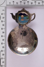
Souvenir tea caddy spoon "Tea Time", Early 1960s
Melbourne Water inherited many of its water assets, such as reservoirs from its predecessor the Melbourne Metropolitan Board of Works (MMBW). They have served the organisation well and have long been celebrated for both their natural beauty and engineering ingenuity. In the nineteenth century Victoria’s fundamental need for water infrastructure went beyond merely functional solutions and reflected the English ideal of the romance and beauty that was embodied in expanses of water. The MMBW further enhanced this notion by incorporating beauty and function in to the Classical and Italianate designs of its infrastructure such as pumping houses and reservoir outlet towers. The reservoir gardens and picnic areas were landscaped with ornamental stonework, exotic trees, decorative flower beds, fern glads pools and rose gardens. All features of the water supply system became widely celebrated as beauty spots that continue to be very popular to this day with tourists and locals alike. This souvenir is a product of that flourishing tourist trade. These water supply sites continue to enhance Melbourne’s charm and liveability and are now recognised as places of cultural and historic significance This souvenir item has been curated by Melbourne Water as it represents an important historical aspect of the organisation by demonstrating the popularity of its water asset sites as recreational places and tourist attractions, and although these sites are functional parts of the water supply system, they were also designed to be enjoyed by the public both aesthetically and recreationally. Tea caddy spoon with clock face engraved showing 4pm on round spoon, tea pot shaped handle with enamel scenic view badge saying 'Healesville' ( depicting Maroondah Reservoir outlet tower). Tea caddy spoon box labelled 'Fine Silverware by Stokes'Stokes and Sons Stokes & Sons logo (Star with S and boomerang) EG. No. 15733melbourne metropolitan board of works, mmbw, maroondah reservoir, melbourne water, scenic view, souvenir, tea caddy spoon -
 Whitehorse Historical Society Inc.
Document - Correspondence, Roads, 01/08/-/09/1933
Correspondence between Secretary, Country Roads Board and Secretary, Shire of Blackburn and Mitcham re maintenance works for 1933 financial year and details of proposed work on main Healesville Road (now Whitehorse Road). Comprises letter, draft response, carbon of response, plans and schedule.roads and streets, victoria. country roads board, shire of blackburn and mitcham, healesville road, whitehorse road, nunawading -
 Eltham District Historical Society Inc
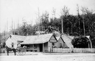
Photograph, M.Jefferson, Watts Bridge Hotel, Fernshaw, Vic
Fernshaw was a rural township 63 km north-east of Melbourne and 10 km north-east of Healesville. Situated on the Watts River, near where a log had fallen making a convenient crossing, Fernshaw was settled in the 1860s. (Source Victorian Places)This photo forms part of a collection of photographs gathered by the Shire of Eltham for their centenary project book,"Pioneers and Painters: 100 years of the Shire of Eltham" by Alan Marshall (1971). The collection of over 500 images is held in partnership between Eltham District Historical Society and Yarra Plenty Regional Library (Eltham Library) and is now formally known as The Shire of Eltham Pioneers Photograph Collection'. It is significant in being the first community sourced collection representing the places and people of the Shire's first one hundred years.Digital imagesepp, shire of eltham pioneers photograph collection, other areas, fernshaw, m.jefferson, watts bridge hotel -
 Eltham District Historical Society Inc
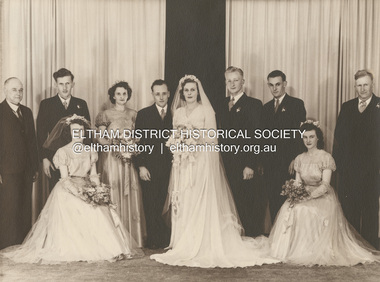
Photograph, Michael Doolay, Wedding of Leslie Ernest Shillinglaw and Alva Elizabeth Thomas, 1949
Standing L-R: Ernest Samuel Shillinglaw, John Thomas, Min Bergin, Leslie Ernest Shillinglaw, Alva Shillinglaw (Nee Thomas), Doug Way, Don Richards, Cecil Thomas Seated L-R: Frances Thomas, Melva Richards (nee Shillinglaw) ENGAGEMENTS The Engagement is announced of Alva Elizabeth, daughter of Mr. and Mrs. C. J. Thomas, Mt. Eliza, to Leslie Ernest, only son of Mr. and Mrs. E. S. Shillinglaw, Healesville. Family Notices (1948, November 13). Healesville Guardian (Lilydale, Vic. : 1942 - 1954), p. 2. Retrieved December 4, 2022, from http://nla.gov.au/nla.news-article60678669marg ball collection, 1949, alva elizabeth shillinglaw (nee thomas), cecil thomas, don richards, doug way, ernest samuel shillinglaw (1888-1958), frances thomas, john thomas, leslie ernest shillinglaw, melva lucy richards (nee shillinglaw), melva lucy shillinglaw, min bergin, wedding -
 Surrey Hills Historical Society Collection
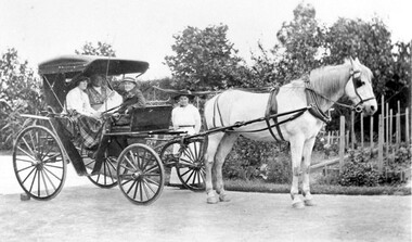
Work on paper - Photograph, "Graceburn" 9 Victoria Crescent Surrey Hills. The Bailey family leavng for an outing in their buggy, c1915
Taken outside ‘Graceburn’, 9 Victoria Crescent. The name 'Graceburn' came from the area in Healesville where the Bailey family came from. The Bailey family were members of the Wyclif Congregational Church. (Ref: Letter from donor dated 26/4/2002.A black and white photograph of a horse and buggy with three people sitting in the buggy and one lady standing beside it. There is a well established garden in the background.surrey hills, victoria crescent, miss florence bailey, graceburn, house names, buggies, horse drawn vehicles, carriage and coaches, horses, clothing and dress -
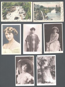 Bendigo Historical Society Inc.
Postcard - WES HARRY COLLECTION: 7 POSTCARDS, 1904 - 05
Seven postcards, all but two are depicting theatre actresses : (a) Miss Gabrielle Ray , (b) Miss Madge Lessing , (c) Miss Gabrielle ray , (d) Miss Julia Marlowe , (e) Nina Sevening , (f) Myers Falls Healesville , (g) Gold sluicing on the Ovens River near Germantown.postcard, various themes, gabrielle ray, madge lessing, julia marlowe, nina sevening, myers falls healesville, gold sluicing, ovens river, germantown -
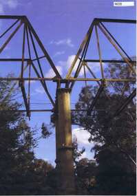 Greensborough Historical Society
Photograph, Maroondah aqueduct pipe bridge 2011, 2011_
in 1891 the Watts River (near Healesville) was tapped. It supplied water to Melbourne, via the Maroondah aqueduct. The Maroondah Reservoir, northeast of Melbourne, was completed in 1927 and water was piped via the Maroondah aqueduct to the northern suburbs. It was replaced by large pipes in the 1980s. Parts of the aqueduct structure remain.Copy of colour photographaqueduct pipe bridge greensborough, maroondah aqueduct -
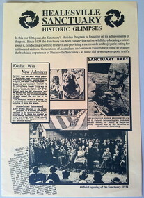 Healesville Sanctuary Heritage Centre
Flyer - program, Circa 1994
The brochure features newspaper articles and snapshots of Healesvile Sanctuary in the 1930's. This is a 4 page pamphlet printed on yellow A3 paper and folded in half. It features activities and information relating to the 60th anniversary of the Healesville Sanctuary. Print is dark green. The back page has a map and opening times of the various exhibits and "Meet the Keeper" times. Includes 3 photographs from old newspapers.healesville-sanctuary, holiday-program, 60th-anniversary, official-opening, map -
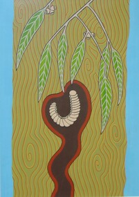 City of Whittlesea Art Collection
Painting - Gouache on paper, Mandy Nicholson, Djerri (Grub)
Born in Healesville, Many Nicholson is a Wurundjeri-willam (Wurundjeri-baluk patriline) artist and Traditional Custodian of Melbourne and surrounds. Mandy also has connections to the Dja Dja wurrung and Ngurai illam wurrung language groups of the Central/Eastern Kulin Nation on her fathers side and German on her mothers.wurundjeri, aboriginal, kulin -
 City of Whittlesea Art Collection
Painting - Gouache on paper, Mandy Nicholson, Yan Yean and Mernda
Born in Healesville, Many Nicholson is a Wurundjeri-willam (Wurundjeri-baluk patriline) artist and Traditional Custodian of Melbourne and surrounds. Mandy also has connections to the Dja Dja wurrung and Ngurai illam wurrung language groups of the Central/Eastern Kulin Nation on her fathers side and German on her mothers.wurundjeri, aboriginal, kulin -
 Whitehorse Historical Society Inc.
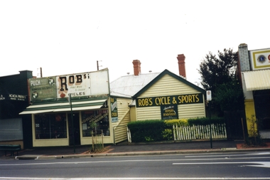
Photograph, Robs Cycles and Sports, 1989
George Robinson opened Robs Cycles in 1945 and worked out of the Blackburn Road Premises until 1999. He was one of the few specialist bike repairer in Melbourne and also did repairs for importers, wholesalers and even other bike shops. George used to race bikes from Blackburn Hotel and Healesville.Coloured photograph of Robs Cycles and Sports shop, Blackburn Road Blackburn, just north of the railway line.robs cycles, robinson, george -
Southern Sherbrooke Historical Society Inc.
Draft Precinct Brochures - Shire of Yarra Ranges, "Shire of Yarra Ranges Neighbourhood Character Study"
Collection of Draft Precinct Brochures in ring binder prepared by the Shire Of Yarra Ranges for public comment. Areas include: Belgrave, Coldstream, Chirnside Park, Healesville, Kilsyth, Lilydale, Monbulk, Montrose, Mooroolbark, Mt. Evelyn, Seville, Seville East, Tecoma, Upwey, Wandin North, Warburton, woori Yallock, Yarra Glen and Yarra Junction. -
 Eltham District Historical Society Inc
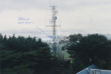
Photograph, View of communications tower from War Memorial tower, Kangaroo Ground, July 1998
Handwritten sketches showing additions to the Police/Emergency services communications tower in 2004. Harry Gilham noted that the cylindrical shaped object was blocking the view from the War Memorial tower to the land area and made suggestions to the Nillumbik Shire Council and CFA that it be raised to the sky area above the Mt St Leonard-Healesville range.Colour photo print 12.5 x 19 cmHandwritten notes on both sides regarding 2004 modificationskangaroo ground, shire of eltham memorial park, emergency services communications tower, harry gilham, nillumbik shire council, war memorial tower -
 Ringwood and District Historical Society
Mixed media - Video, RDHS Guest Speaker Presentation - "Orcharding and Memories of Wonga Park" - Alan Upton
Digitised video (3.06GB) Duration: 56 minutes. Recorded November, 2019 (Video is available for viewing at Ringwood & District Historical Society Archives by appointment)Presenter: Alan Upton has spent his life growing fruit, both at the original Upton orchard in Wonga Park and at Yering on the Healesville Road. In that time, there have been many changes to not only agricultural methods and techniques but also to the local area, as covered by Alan in this video presentation. -
Eltham District Historical Society Inc
Document - Folder, Parry, Robert
Robert Parry (1824-?) came to Melbourne from Wales in 1850, marrying Margaret Brett, a fellow passenger. He worked for James Donaldson at Kangaroo Ground, returning after success at gold mining. He began as a carter and settled near Healesville. Contents Photocopy: "The Upper Yarra District" page 413, biography of Robert Parry.Newspaper clippings, A4 photocopies, etcrobert parry, margaret parry nee brett, james donaldson, kangaroo ground, john hicks petty -
 Marysville & District Historical Society
Photograph (Item) - Black and white bi-focal image, Unknown
An early black and white bi-focal image of men and packhorses on the Marysville-Wood's Point Road in Marysville in Victoria.An early black and white bi-focal image of men and packhorses on the Marysville-Wood's Point Road in Marysville in Victoria. This is now known as the Marysville-Wood's Point Road. The Marysville-Woods Point Road was originally part of the Yarra Track, constructed in the early 1860s to provide access between Healesville and the Woods Point Goldfields. Despite the steep terrain and engineering difficulties, the Yarra Track soon became a busy route used by pack horses, horse-drawn drays, and wagons. Today this sealed mountain road is a popular scenic drive between Marysville and Warburton.Packhorses on Wood'spoint Road/ Marysville/ Victoriapackhorses, wood's point road, marysville-wood's point road, marysville, victoria, yarra track, healesville, wood's point goldfields, warburton -
Marysville & District Historical Society
Booklet (Item) - Information booklet, Artworkz Tourism, The Big Culvert, Unknown
An information booklet that was produced as a guide to The Big Culvert.An information booklet that was produced as a guide to The Big Culvert. The Big Culvert is a historic granite and bluestone arch along the Yarra Track, a major route to Melbourne through the 1800s. Built in 1870 and a major piece of infrastructure for its time, the heritage listed culvert allowed water to flow under often-flooded the road. The Yarra Track is the former name of the gold fields road from Healesville to the Woods Point and Jordan Goldfields, in Victoria, Australia. A direct route via the Yarra River and the Great Divide was discovered by Rieck in September 1862 and became known as the Yarra Track. Early in 1863, the Victorian Government decided to construct a 193-kilometre (120 mile) road along the route. Its original width varied between 4 and 6 metres (12 and 20 feet), and was designed to accommodate horse-drawn vehicles. The Track involved the climbing of the Black Spur, descent into the Acheron Valley, and then through Marysville to the Cumberland where it followed the existing route.the big culvert, yarra track, victoria, healesville, wood's point goldfields, jordan goldfields, black spur, acheron valley, cumberland valley -
Marysville & District Historical Society
Flyer (Item) - Information flyer, Artworkz Tourism, The Big Culvert, 26-03-2016
An information flyer that was produced as a guide to The Big Culvert.An information flyer that was produced as a guide to The Big Culvert. The Big Culvert is a historic granite and bluestone arch along the Yarra Track, a major route to Melbourne through the 1800s. Built in 1870 and a major piece of infrastructure for its time, the heritage listed culvert allowed water to flow under often-flooded the road. The Yarra Track is the former name of the gold fields road from Healesville to the Woods Point and Jordan Goldfields, in Victoria, Australia. A direct route via the Yarra River and the Great Divide was discovered by Rieck in September 1862 and became known as the Yarra Track. Early in 1863, the Victorian Government decided to construct a 193-kilometre (120 mile) road along the route. Its original width varied between 4 and 6 metres (12 and 20 feet), and was designed to accommodate horse-drawn vehicles. The Track involved the climbing of the Black Spur, descent into the Acheron Valley, and then through Marysville to the Cumberland where it followed the existing route.the big culvert, yarra track, victoria, healesville, wood's point goldfields, jordan goldfields, black spur, acheron valley, cumberland valley -
 Marysville & District Historical Society
Photograph (Item) - Black and white photograph, Unknown
A black and white photograph taken at the unveiling of the sign placed at The Big Culvert.A black and white photograph taken at the unveiling of the sign placed at The Big Culvert. The Big Culvert is a historic granite and bluestone arch along the Yarra Track, a major route to Melbourne through the 1800s. Built in 1870 and a major piece of infrastructure for its time, the heritage listed culvert allowed water to flow under often-flooded the road. The Yarra Track is the former name of the gold fields road from Healesville to the Woods Point and Jordan Goldfields, in Victoria, Australia. A direct route via the Yarra River and the Great Divide was discovered by Rieck in September 1862 and became known as the Yarra Track. Early in 1863, the Victorian Government decided to construct a 193-kilometre (120 mile) road along the route. Its original width varied between 4 and 6 metres (12 and 20 feet), and was designed to accommodate horse-drawn vehicles. The Track involved the climbing of the Black Spur, descent into the Acheron Valley, and then through Marysville to the Cumberland where it followed the existing route.Unveiling of sign/ at "Big Culvert" In front Max Cockerrell and - Rear: second back Geoff Pope R.H.S. rear: Nancy "/ Anne "the big culvert, yarra track, victoria, healesville, wood's point goldfields, jordan goldfields, black spur, acheron valley, cumberland valley -
 Marysville & District Historical Society
Photograph (Item) - Colour photograph, 20-09-2008
A colour photograph of the entrance to The Big Culvert.A colour photograph of the entrance to The Big Culvert. The Big Culvert is a historic granite and bluestone arch along the Yarra Track, a major route to Melbourne through the 1800s. Built in 1870 and a major piece of infrastructure for its time, the heritage listed culvert allowed water to flow under often-flooded the road. The Yarra Track is the former name of the gold fields road from Healesville to the Woods Point and Jordan Goldfields, in Victoria, Australia. A direct route via the Yarra River and the Great Divide was discovered by Rieck in September 1862 and became known as the Yarra Track. Early in 1863, the Victorian Government decided to construct a 193-kilometre (120 mile) road along the route. Its original width varied between 4 and 6 metres (12 and 20 feet), and was designed to accommodate horse-drawn vehicles. The Track involved the climbing of the Black Spur, descent into the Acheron Valley, and then through Marysville to the Cumberland where it followed the existing route.the big culvert, yarra track, victoria, healesville, wood's point goldfields, jordan goldfields, black spur, acheron valley, cumberland valley -
 Marysville & District Historical Society
Photograph (Item) - Black and white photograph, Unknown
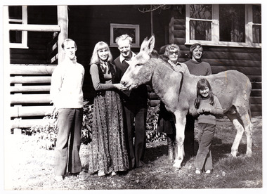
A black and white photograph of the Lingard Family of Marysville's "Crossways" restaurant. The Crossways was built in the early 1920s and is the oldest building in Marysville. The Crossways historic inn survived the 2009 Black Saturday bushfires thanks to the efforts of its co-owner Greg Cherry and, in the days after the fires, provided a much-needed refuge to the Marysville community and firefighters.A black and white photograph of the Lingard Family of Marysville's "Crossways" restaurant.Part 2 of/ Series Photographer: Colleen Myer/ 185 Maroondah Highway/ Healesville. MINE HOSTS The Lingard Family/ of Marysville's "Crossways"/ restaurant From left: Colin Lawrey (Chef, partner/ and "one of the family", Elizabeth, James/ Jean and David Lingard - with/ "Casey" the donkey, and the Lingards'/ niece Kathy.marysville, victoria, australia, the crossways cabaret, the crossways, crossways, crossways country inn, crossways historic inn, 2009 black saturday bushfires, accommodation, photograph, lingard family, colin lawrey -
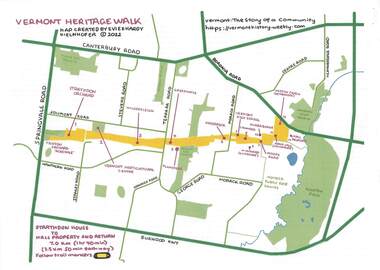 Ringwood and District Historical Society
Pamphlet - Map and Guide Notes, Vermont Heritage Walk, Vermont, Victoria - 2022
Double-sided A4 map and 9-page A4 guide notes with QR codes outlining historical and environmental points of interest for participants' walking tour of "Healesville Freeway Reserve" between Springvale Road and Boronia Road, Vermont, Vic - 3.5km, 50 minutes each way. Vermont Heritage Walk map and notes produced by Evie and Hardy Kielnhofer. -
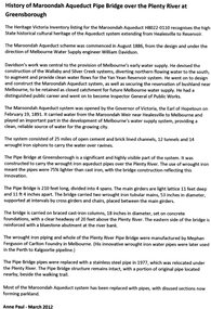 Greensborough Historical Society
Article, Anne Paul, History of Maroondah Aqueduct Pipe Bridge over the Plenty River at Greensborough, by Anne Paul, 2012_03
The Maroondah Aqueduct pipe bridge, opened in 1891, was an important part of the system carrying water from the Maroondah Reservoir near Healesville to Melbourne. Most of the original system has been replaced by stainless steel pipes, the Greensborough section now running under the Plenty River since 1977. The original pipe bridge can still be seen over the Plenty River at Greensborough.2 p. typescriptaqueduct pipe bridge greensborough, maroondah aqueduct, melbourne water supply, anne paul -
 Surrey Hills Historical Society Collection
Work on paper - Photograph, Playground at "Graceburn" 9 Victoria Crescent Surrey Hills, c1909-10
Joseph Bailey built an elaborate playground for his children, as illustrated by this high slide and long see-saw. They were not allowed to play on this equipment on a Sunday. The name 'Graceburn' came from the area in Healesville where the Bailey family came from. The Bailey family were members of the Wyclif Congregational Church. (Ref: Letter from donor dated 26/4/2002.A black and white photograph of two people on a seesaw in a garden setting. There is a long slide in the background.surrey hills, victoria crescent, mr joseph bailey, seesaws, slides, playgrounds, graceburn, house names -
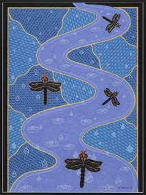 Merri-bek City Council
Acrylic on watercolour paper, Mandy Nicholson, Birrarung dragonflies in the rain, 2006
Primarily a painter, Mandy Nicholson also produces ceramics, carvings, murals, prints, designs and children’s clothing. Born in 1975, Nicholson was raised in Healesville and belongs to the Wurundjeri-willam (Woiwurrung language) clan of the Kulin Nation. Mandy’s paintings often represent important cultural rituals and are executed in her distinct graphic style. She uses the traditional motifs of her people blended with contemporary interpretation. -
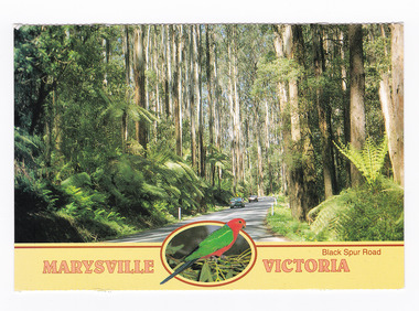 Marysville & District Historical Society
Postcard (item) - Colour postcard, Neil Cutts, Marysville Victoria-Black Spur Road, Pre 2009
A postcard in a series produced by the Rose Stereograph Company in Victoria, Australia as a souvenir of Marysville.A colour photograph of the Black Spur Road near Marysville in Victoria. The Black Spur is known to be one of Victoria's most scenic drives. The road winds through a majestic forest of trees and tree ferns from Healesville to Narbethong and is part of the Maroondah Highway. Rose Series postcard No. 3528. POST CARD The "Rose" Series/ De Luxe Proudly Printed in/ Australia Since 1880 AFFIX/ STAMP/ HERE/ Rose Series/ Post Card No./ 3528 ADDRESS/ POSTCODE Mountain Ash and Treeferns/ Black Spur Road/ MARYSVILLE, VICTORIA, AUSTRALIA/ Photo Neil Cutts Copyright Rose Stereograph Co., Glen Waverley, Victoria (03) 9560 7772marysville, victoria, black spur road, postcard, souvenir, rose series postcard, 3528, healesville, narbethong, maroondah highway -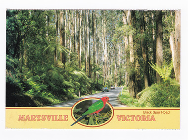
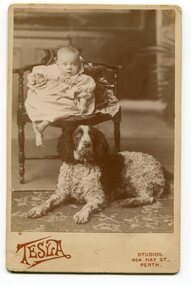 Orbost & District Historical Society
black and white photograph, December 1899
According to records searched, Donald John Hatton was born born in 1899 in Perth. His father was John and mother was Annie Rebecca Perry Hendon(?) He died in Victoria, aged 78, at Box Hill. This photograph could be related to the Rev, L. W. Hatton and Mrs. Hatton formerly of Healesville Presbyterian Church. They left there in January 1947 to take over Mr. Hatton's new charge at Orbost..A black / white photograph on a cream coloured buff card with red print at the bottom. It is of a small child sitting on a chair with a large dog sitting at the child's feet. on back - "Donald John Hatton, Xmas 1899" on front - "Tesla Studios 464 Hay Street Perth"hatton-donald-john -
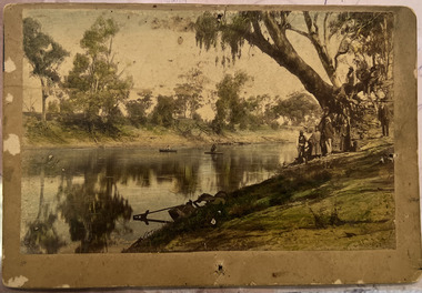 Kew Historical Society Inc
Photograph - Wurundjeri People at Studley Park
The Wurundjeri Woi Wurrung People were the original owners of the land on which the City of Boroondara is now located. They made active use of the Yarra for food and transport [an original canoe is held in the collection of the Melbourne Museum]. From 1863, members of the Wurundjeri Woi Wurrung were resettled at the Corranderrk Aboriginal reserve at Healesville. The [now] best known member of the Wurundjeri People was William Barak, who may be pictured here.If the attribution in the annotation is correct, then this may be the earliest photograph of members of the Wurundjeri People at Kew. The photo may be unique.Hand tinted photograph on mounting card of members of the Wurundjeri Woi Wurrung on the banks of the River Yarra, allegedly at Studley Park before 1855 [according to the annotation on the reverse] The photograph of the river and its near and far banks includes two boats on the river, a row boat and a canoe, and people standing on the near bank or seated on the branch of a tree. In addition to men and women of the Wurundjeri People, there appears to be two Europeans pictured, one wearing a hat and the other standing at right. Annotations on the reverse identify a [possible] location and date. [Size: Mount 140 x 215mm | Photograph 125 x 190mm]Various hands and dates: "Original lead pencil lettering Studley Yarra Yarra / Yarra Yarra Studley / Studley (Park?) / Note aboriginals in a bark canoe / Prior 1855 / Very early photo Yarra River originally known as the Yarra Yarra / [illegible part word in ink]".wurundjeri woi wurrung, yarra river, aboriginal and torres straight islander -
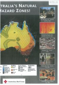 Bendigo Historical Society Inc.
Document - Map outlining Australia's natural hazard zones
John Perry collection. Laminated document. Color. Map of Australia in the middle of document surrounded by 10 images of natural disasters that have occurred in Australia in Cairns, Darwin, Cleve, Northam, Central Queensland, Mt. Macedon, Dandenong Ranges, Benalla, Healesville, and Charleville. Legend demonstrates different types of natural disasters and zones in which they are more likely to occur. Has logo of Australian Red Cross at the bottom of document. map, tornado, cyclone, flood, drought, natural disasters