Showing 541 items matching "kangaroo ground road"
-
 Eltham District Historical Society Inc
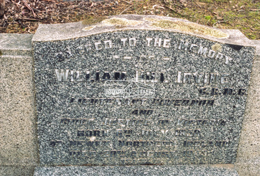
Negative - Photograph, Harry Gilham, Grave of William Hill and Agnes Somerville Irvine and family, Eltham Cemetery, Victoria, 1 Aug 2007
William Hill Irvine was born 6 July, 1858 in Newry, County Down, Ireland. He arrived in Melbourne December 1879 and taught at Geelong College. He was admitted to the Supreme Court in 1884 having qualified from Melbourne University and practiced in Melbourne. In 1891 he married Agnes Somerville Wanliss and they had one son, William Mitchell (1901 Armadale) and two daughters, Beatrice Wanliss (1899 Armadale) and Agnes Somerville Wanliss (1903 Armadale). Sir William Irvine sat in the Victorian Parliament (as Liberal Member for Lowan) from 1894 to 1906 and was Premier of Victoria from 1902 to 1904. He then switched to Federal politics and sat in the Commonwealth Parliament (as Liberal Member for Flinders) from 1906 to 1918. He was considered a potential Prime Minister, but his abrupt manner and hard-line conservatism (particularly his attitude to a railway strike) made him unacceptable even to many Liberals: he was known in Parliament as "Iceberg Irvine". He lived at Richmond, but in 1908 purchased land in Laughing Waters Road at Eltham, where he built the house ‘Killeavey’, initially as a weekend retreat. The site, a peninsula surrounded on three sides by the Yarra River, is of geological importance and has considerable cultural significance to the Wurundjeri. In 1912 Sir William moved to Killeavey and in 1913 purchased more land, extending his property to Reynolds Road. In 1923 he shifted to Toorak, donating Killeavey to his daughter Beatrice as a wedding gift. Sir William was a founding member of the RACV and was Acting Governor of Victoria from 1931 to 1934. He was also a notable public figure involved in several local events including the: 1919 Unveiling of Eltham War Obelisk 1921 Eltham Primary School Extensions 1921 Eltham Primary School Roll of Honour of prior students 1928 Opening of Eltham Higher Elementary School 1926 Unveiling the Shire of Eltham War Memorial in Memorial Park at Kangaroo Ground He died in 1943 and is buried in Eltham Cemetery with his wife Agnes along with son William Mitchell Irvine and his wife, Dora Haswell Sacred to the memory of William Hill Irvine G.C.M.G. Lieutenant Governor And Chief Justice of Victoria Born 6th July 1858 At Newry, Northern Ireland Died 20th August 1943 Also his wife Agnes Somerville Born at Ballarat 16th Nov 1867 Died at Eltham 16th Aug 1954 W. M. W. Irvine 1901-1975 And Dora Haswell Wife of W. M. W. Irvine 1900-1979eltham cemetery, gravestones, memorials, agnes sommerville irvine (nee wanliss), dora haswell irvine, william hill irvine, william mitchell irvine -
 Eltham District Historical Society Inc
Photograph - Colour Print, Belle Vue, Livingstone Road, Eltham, c.2015
... Research. It was traversed by the main road to Kangaroo Ground... Research. It was traversed by the main road to Kangaroo Ground ...Belle Vue property in Livingstone Road, Eltham was once owned by Society member Jo McCormick. Jo was a valued member of our committee and dear friend of many of our members until her death in 2009. Belle Vue is the farmhouse of a property that is now a significant part of suburban Eltham, just a short distance north of the town centre. Originally purchased by pioneer Eltham farmer Henry Stooke, the present-day old farmhouse sits within an extensive suburban residential area. The history of the property is largely based on a heritage assessment prepared by consultant Lorraine Huddle for Nillumbik Shire Council. Additional information from our Society records reveals Belle Vue farm comprised about 56 ha (140 acres) extending northerly from the northern boundary of Holloway’s 1851 Little Eltham subdivision. On the present day map the southern boundary was just north of Elsa Court and Grove Street. The western boundary was the Diamond Creek and extended northerly to Main Road where it turns easterly towards Research. It was traversed by the main road to Kangaroo Ground and beyond and from 1912 by the railway to Hurstbridge. From 1895 the farm was owned by William Williams and his wife Mary Ann. In 1914 -15 they built a new house now known as Belle Vue. They sold the land in 1920 and residential subdivision began soon after that. Belle Vue remains today on a substantially subdivided and very much reduced size residential lot in Livingstone Road. The house and many old trees on the site were subject to a heritage overlay under the Nillumbik Planning Scheme. Despite that overlay, the development and subdivision of the original land resulted in most of the heritage listed trees being removed. belle vue, eltham, livingstone road -
 Eltham District Historical Society Inc
Document - Property Binder, 1045 Main Road, Eltham
... Old Eltham Road Kangaroo Ground Nillumbik Council Barry ...Businesses, Eltham, Eltham Physiotherapy & Sports Injuries, Main Roadmain road, eltham, property, shops, businesses, russell yeoman, jim connor, eltham district historical society, plenty river, old eltham road, kangaroo ground, nillumbik council, barry rochford, main road eltham, luck street eltham, aladdin antiques montmorency, main road eltham roundabout, steven white, geoff glynn, michael murray, harold herd, enver camdal, helen bodycomb, rhonda noble, jeph neale, chris marks, john brumby, andrew haermeyer, sherryl garbutt, eltham shopping centre, eltham chamber of commerce and industry, norman williams, pat power, john graves, wattletree road eltham, bolton street eltham -
 Eltham District Historical Society Inc
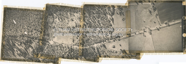
Photograph - Aerial Photograph, Main Road, Research/Kangaroo Ground, from Cassells Rd to New Rd, 2 Jul. 1951
... Main Road, Research/Kangaroo Ground, from Cassells Rd to... together Main Road, Research/Kangaroo Ground, from Cassells Rd ...shire of eltham archives, aerial photo, main road, cassells road, research (vic.), new road -
 Eltham District Historical Society Inc
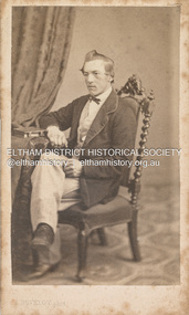
Photograph, Louis Buvelot, Possibly Phillip Shillinglaw, 1865
Famous Swiss landcape painter Louis Buvelot came to Melbourne in 1864 and set up a portrait photography studio which he operated for one year only in 1865. This photograph is believed to be the oldest photo in the Shillinglaw Family Album collection. It is believed that the subject is a young Phillip Shillinglaw, without beard, at age 22 or 23. Phillip Shillinglaw was born Melbourne, August 7, 1842. He married Sarah Ann Kidd in Heidelberg, Victoria, February 28, 1872. In 1881 Phillip and Sarah and their small family moved to Eltham and made home in what was later to become known as Shillinglaw Cottage but which Phillip named 'Wattle Brae'. Shillinglaw Cottage is significant to Eltham’s local history. It is one of the earliest known buildings still in existence. Records suggest that the cottage was built circa 1859 by a man named Cochrane, believed to be Thomas Cochrane, in conjunction with George Stebbings though it is not known what Stebbings’s contribution was. It is believed Stebbings owned the cottage between 1874 and 1888. According to Margaret Ball’s (2017) book Shillinglaw Family of Eltham 1660-2007, Thomas Cochrane and family lived there from 1867 to 1874 however this is contrary to the records of assessable rates levied by the Eltham District Road Board, established in 1858, which shows Cochrane was the owner occupier (in Little Eltham) of approximately 25 acres of cultivated land and 25 acres of pastureland upon which a hut was sited in 1860. It is suspected that George Stebbings may have acquired the property from Cochrane in 1874 as it is noted that he had a tenant for a period, James Rossiter, who was the editor for the Evelyn Observer in Kangaroo Ground in 1874 (LATE SHIRE OFFICE AT KANGAROO GROUND (1934, February 16). Advertiser (Hurstbridge, Vic. : 1922 - 1939), p. 5. Retrieved February 25, 2022, from http://nla.gov.au/nla.news-article56743657). In 1881 Phillip Shillinglaw became the ratepayer for the cottage though Stebbings retained ownership until 1888 at which time it was transferred to Shillinglaw. Photographer: Louis Buvelot Swiss landscape painter and portrait photographer, settled in Melbourne in 1864, admired by the artists from the Heidelberg area such as Tom Roberts and Arthur Streeton who bestowed him with the accolade of 'Father of Australian painting’. In the 1870s, his work increasingly drew elements from Australian landscape such as the bush land in works like Lilydale (1878) and Bush Track. "Louis Buvelot :: biography at :: at Design and Art Australia Online." Daao https://www.daao.org.au/bio/louis-buvelot/biography/. Accessed 9 Mar. 2023. On arriving in Melbourne in February 1865 Buvelot bought a photographer's studio at 92 Bourke Street East and took portraits for a year. In 1866 he moved to 88 La Trobe Street East and resumed his painting while Caroline-Julie gave French lessons to help Buvelot to establish himself as an artist in Melbourne. "Biography - Abram-Louis Buvelot." Australian Dictionary of Biography https://adb.anu.edu.au/biography/buvelot-abramlouis-3132. Accessed 2 Dec. 2022. CARTE-DE-VISITE (cdv) 1857-1890 Cartes-de-visite (cdv's) are the most common form of photograph from the nineteenth century, generally measuring two and a half inches by four and an eighth inches (6.3 x 10.5 cm) when mounted, sepia toned, mounted on a card which was generally printed with the photographer's name and address on the back or beneath the portrait. - Frost, Lenore; Dating Family Photos 1850-1920; Valiant Press Pty. Ltd., Berwick, Victoria 1991marg ball collection, shillinglaw family photo album 1, 1865, l. buvelot photographer, louis buvelot, phillip shillinglaw (1842-1914), unknown -
 Eltham District Historical Society Inc
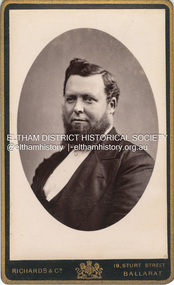
Photograph, Phillip Shillinglaw, c.1885
Photographer: Richards & Co. Portrait Parlours operated from 19 Sturt Street, Ballarat from 1881-1921 but with "Under Royal Patronage" appears to be 1881-1885. Phillip Shillinglaw was born Melbourne, August 7, 1842. He married Sarah Ann Kidd in Heidelberg, Victoria, February 28, 1872. In 1881 Phillip and Sarah and their small family moved to Eltham and made home in what was later to become known as Shillinglaw Cottage but which Phillip named 'Wattle Brae'. Shillinglaw Cottage is significant to Eltham’s local history. It is one of the earliest known buildings still in existence. Records suggest that the cottage was built circa 1859 by a man named Cochrane, believed to be Thomas Cochrane, in conjunction with George Stebbings though it is not known what Stebbings’s contribution was. It is believed Stebbings owned the cottage between 1874 and 1888. According to Margaret Ball’s (2017) book Shillinglaw Family of Eltham 1660-2007, Thomas Cochrane and family lived there from 1867 to 1874 however this is contrary to the records of assessable rates levied by the Eltham District Road Board, established in 1858, which shows Cochrane was the owner occupier (in Little Eltham) of approximately 25 acres of cultivated land and 25 acres of pastureland upon which a hut was sited in 1860. It is suspected that George Stebbings may have acquired the property from Cochrane in 1874 as it is noted that he had a tenant for a period, James Rossiter, who was the editor for the Evelyn Observer in Kangaroo Ground in 1874 (LATE SHIRE OFFICE AT KANGAROO GROUND (1934, February 16). Advertiser (Hurstbridge, Vic. : 1922 - 1939), p. 5. Retrieved February 25, 2022, from http://nla.gov.au/nla.news-article56743657). In 1881 Phillip Shillinglaw became the ratepayer for the cottage though Stebbings retained ownership until 1888 at which time it was transferred to Shillinglaw. CARTE-DE-VISITE (cdv) 1857-1890 Cartes-de-visite (cdv's) are the most common form of photograph from the nineteenth century, generally measuring two and a half inches by four and an eighth inches (6.3 x 10.5 cm) when mounted, sepia toned, mounted on a card which was generally printed with the photographer's name and address on the back or beneath the portrait. - Frost, Lenore; Dating Family Photos 1850-1920; Valiant Press Pty. Ltd., Berwick, Victoria 1991marg ball collection, shillinglaw family photo album 1, phillip shillinglaw (1842-1914), 1881-1885, 1885, richards & co. photographers 19 sturt st ballarat -
 Eltham District Historical Society Inc
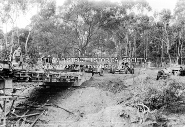
Album - Photograph, J.A. McDonald, Henley Road Bridge over Watsons Creek, Aug. 1962
... Kangaroo Ground Oxley Bridge Watsons Creek H941 stamped on reverse ...Henley Road Bridge over Watsons Creek Eltham Abutment August 1962Record of various Shire of Eltham infrastructure works undertaken during the period of 1952-1962 involving bridge and road reconstruction projects, sometimes with Eltham Shire Council Project Reference numbers quoted. It was during this period that a number of significant improvements were made to roads and new bridges constructed within the shire that remain in place as of present day (2022). In many situations, the photos provide a tangible visible record of infrastructure that existed throughout the early days of the Shire. The album was put together by or under the direction of the Shire Engineer, J.A. McDonald.H941 stamped on reverse (film processing #)infrastructure, shire of eltham, bridge construction, road construction, bushfires, 1962-08, bend of islands, henley road, henley road bridge, kangaroo ground, oxley bridge, watsons creek -
 Eltham District Historical Society Inc
Album - Photograph, J.A. McDonald, Henley Road Bridge over Watsons Creek, Aug. 1962
... Kangaroo Ground Oxley Bridge Watsons Creek H941 stamped on reverse ...Henley Road Bridge over Watsons Creek Yarra Glen Abutment August 1962Record of various Shire of Eltham infrastructure works undertaken during the period of 1952-1962 involving bridge and road reconstruction projects, sometimes with Eltham Shire Council Project Reference numbers quoted. It was during this period that a number of significant improvements were made to roads and new bridges constructed within the shire that remain in place as of present day (2022). In many situations, the photos provide a tangible visible record of infrastructure that existed throughout the early days of the Shire. The album was put together by or under the direction of the Shire Engineer, J.A. McDonald.H941 stamped on reverse (film processing #)infrastructure, shire of eltham, bridge construction, road construction, bushfires, 1962-08, bend of islands, henley road, henley road bridge, kangaroo ground, oxley bridge, watsons creek -
 Eltham District Historical Society Inc
Album - Photograph, J.A. McDonald, Henley Road Bridge over Watsons Creek, Sep. 1962
... bushfires Bend of Islands Henley Road Henley Road Bridge Kangaroo ...Henley Road Bridge over Watsons Creek Eltham Abutment September 1962Record of various Shire of Eltham infrastructure works undertaken during the period of 1952-1962 involving bridge and road reconstruction projects, sometimes with Eltham Shire Council Project Reference numbers quoted. It was during this period that a number of significant improvements were made to roads and new bridges constructed within the shire that remain in place as of present day (2022). In many situations, the photos provide a tangible visible record of infrastructure that existed throughout the early days of the Shire. The album was put together by or under the direction of the Shire Engineer, J.A. McDonald.H941 stamped on reverse (film processing #)infrastructure, shire of eltham, bridge construction, road construction, bushfires, bend of islands, henley road, henley road bridge, kangaroo ground, oxley bridge, watsons creek, 1962-09 -
 Eltham District Historical Society Inc
Album - Photograph, J.A. McDonald, Henley Road Bridge over Watsons Creek, Sep. 1962
... bushfires Bend of Islands Henley Road Henley Road Bridge Kangaroo ...Henley Road Bridge over Watsons Creek Yarra Glen Abutment September 1962Record of various Shire of Eltham infrastructure works undertaken during the period of 1952-1962 involving bridge and road reconstruction projects, sometimes with Eltham Shire Council Project Reference numbers quoted. It was during this period that a number of significant improvements were made to roads and new bridges constructed within the shire that remain in place as of present day (2022). In many situations, the photos provide a tangible visible record of infrastructure that existed throughout the early days of the Shire. The album was put together by or under the direction of the Shire Engineer, J.A. McDonald.H941 stamped on reverse (film processing #)infrastructure, shire of eltham, bridge construction, road construction, bushfires, bend of islands, henley road, henley road bridge, kangaroo ground, oxley bridge, watsons creek, 1962-09 -
 Eltham District Historical Society Inc
Album - Photograph, J.A. McDonald, Garden Hill, Kangaroo Ground, c. 1962
Garden Hill burnt following bush fires - most likely the 15-16 Jan 1962 fire A helicopter can be seen flying over the top of the hill Eltham Shire Council purchased this property in the early 1970s and it has now been incorpoarted within the Shire of Eltham Memorial ParkRecord of various Shire of Eltham infrastructure works undertaken during the period of 1952-1962 involving bridge and road reconstruction projects, sometimes with Eltham Shire Council Project Reference numbers quoted. It was during this period that a number of significant improvements were made to roads and new bridges constructed within the shire that remain in place as of present day (2022). In many situations, the photos provide a tangible visible record of infrastructure that existed throughout the early days of the Shire. The album was put together by or under the direction of the Shire Engineer, J.A. McDonald.1962, garden hill, kangaroo ground, shire of eltham memorial park, victorian bushfires - 1962 -
 Eltham District Historical Society Inc
Document - Property Binder, 820 Main Road, Eltham
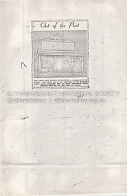
Photocopy newspaper clipping: Out of the Past, 1958, photograph of first post office at Eltham in 1880s, image owned by the Burgoyne family who had long association with the Postal Department. Photocopy Tabular Return of Post Offices in Victoria 1855-1856, including Kangaroo Ground (Andrew Ross), Little Eltham (Thomas Hunniford, Saint Andrew (William Watson). Typed newspaper article: District Roads Boards, The Argus 2 October 1867, re opening of post office savings banks and money order offices at (among others) Eltham. Index card: Thomas Hunniford, Anne Hunniford, Eltham Post Office, Eltham Telegraph Office. Letter Nillumbik Shire to Eltham District Historical Society, 9 December 2015, re Planning Application 377/2015/06P. Letter Nillumbik Shire to Eltham District Historical Society, 2 February 2016, conference re Planning Application 377/2015/06P.. Newspaper article: Beauty is in the eye of the beholder, Manningham and Nillumbik Bulletin, November 2021, re stonework on building.main road, eltham, property, businesses, eltham post office, burgoyne family, kangaroo ground post office, little eltham post office, saint andrew post office, andrew ross, thomas hunniford, william watson, anne hunniford, eltham telegraph office -
 Eltham District Historical Society Inc
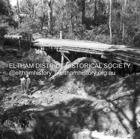
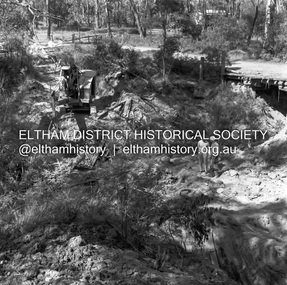
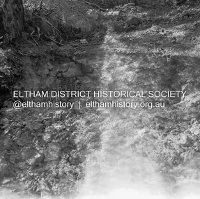
Negative - Photograph, J.A. McDonald, Henley Road at Watsons Creek, Mar. 1961
... Henley Road Henley Road Bridge Kangaroo Ground Oxley Bridge ...Old bridge over Watsons Creek 22 March 1961 Cr. Pelling and Contractor WolfRecord of various Shire of Eltham infrastructure works undertaken during the period of 1952-1962 involving bridge and road reconstruction projects, sometimes with Eltham Shire Council Project Reference numbers quoted. It was during this period that a number of significant improvements were made to roads and new bridges constructed within the shire that remain in place as of present day (2022). In many situations, the photos provide a tangible visible record of infrastructure that existed throughout the early days of the Shire. The album was put together by or under the direction of the Shire Engineer, J.A. McDonald.infrastructure, shire of eltham, 1961-03, bend of islands, cr. charis pelling, henley road, henley road bridge, kangaroo ground, oxley bridge, watsons creek, w.e. wolf, bridge construction, road construction -
 Eltham District Historical Society Inc
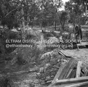
Negative - Photograph, J.A. McDonald, Henley Road at Watsons Creek, Mar. 1961
... Henley Road Bridge Kangaroo Ground Oxley Bridge Watsons Creek W.E ...Henley Road at Watsons Creek Looking easterly along new alignment, 22 March 1961 C. Browns Excavator Contractor Wolf Cr PellingRecord of various Shire of Eltham infrastructure works undertaken during the period of 1952-1962 involving bridge and road reconstruction projects, sometimes with Eltham Shire Council Project Reference numbers quoted. It was during this period that a number of significant improvements were made to roads and new bridges constructed within the shire that remain in place as of present day (2022). In many situations, the photos provide a tangible visible record of infrastructure that existed throughout the early days of the Shire. The album was put together by or under the direction of the Shire Engineer, J.A. McDonald.infrastructure, shire of eltham, 1961-03, bend of islands, cr. charis pelling, henley road, henley road bridge, kangaroo ground, oxley bridge, watsons creek, w.e. wolf, bridge construction, road construction -
 Eltham District Historical Society Inc
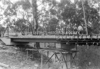
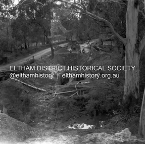
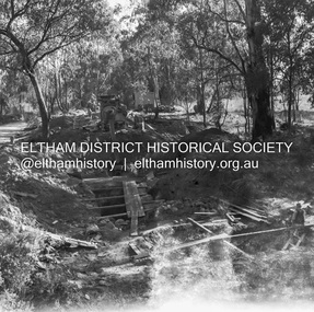
Negative - Photograph, J.A. McDonald, Henley Road at Watsons Creek, Apr. 1961
... Bridge Kangaroo Ground Oxley Bridge Watsons Creek W.E. Wolf ...Henley Road at Watsons Creek looking easterly along centreline from west abutment Early April 1961Record of various Shire of Eltham infrastructure works undertaken during the period of 1952-1962 involving bridge and road reconstruction projects, sometimes with Eltham Shire Council Project Reference numbers quoted. It was during this period that a number of significant improvements were made to roads and new bridges constructed within the shire that remain in place as of present day (2022). In many situations, the photos provide a tangible visible record of infrastructure that existed throughout the early days of the Shire. The album was put together by or under the direction of the Shire Engineer, J.A. McDonald.infrastructure, shire of eltham, bend of islands, cr. charis pelling, henley road, henley road bridge, kangaroo ground, oxley bridge, watsons creek, w.e. wolf, bridge construction, road construction, 1961-04 -
 Eltham District Historical Society Inc
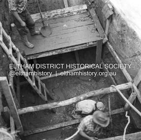
Negative - Photograph, J.A. McDonald, Henley Road at Watsons Creek, Apr. 1961
... Road Henley Road Bridge Kangaroo Ground Oxley Bridge Watsons ...Henley Road at Watsons Creek showing excavation at western pier Rock at contract level, slight underground flow Early April 1961Record of various Shire of Eltham infrastructure works undertaken during the period of 1952-1962 involving bridge and road reconstruction projects, sometimes with Eltham Shire Council Project Reference numbers quoted. It was during this period that a number of significant improvements were made to roads and new bridges constructed within the shire that remain in place as of present day (2022). In many situations, the photos provide a tangible visible record of infrastructure that existed throughout the early days of the Shire. The album was put together by or under the direction of the Shire Engineer, J.A. McDonald.infrastructure, shire of eltham, bend of islands, cr. charis pelling, henley road, henley road bridge, kangaroo ground, oxley bridge, watsons creek, w.e. wolf, bridge construction, road construction, 1961-04 -
 Eltham District Historical Society Inc
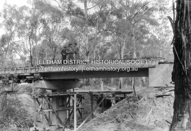
Negative - Photograph, J.A. McDonald, Henley Road at Watsons Creek, Apr. 1961
... Bridge Kangaroo Ground Oxley Bridge Watsons Creek W.E. Wolf ...Henley Road at Watsons Creek looking westerly along centreline from east abutment Early April 1961Record of various Shire of Eltham infrastructure works undertaken during the period of 1952-1962 involving bridge and road reconstruction projects, sometimes with Eltham Shire Council Project Reference numbers quoted. It was during this period that a number of significant improvements were made to roads and new bridges constructed within the shire that remain in place as of present day (2022). In many situations, the photos provide a tangible visible record of infrastructure that existed throughout the early days of the Shire. The album was put together by or under the direction of the Shire Engineer, J.A. McDonald.infrastructure, shire of eltham, bend of islands, cr. charis pelling, henley road, henley road bridge, kangaroo ground, oxley bridge, watsons creek, w.e. wolf, bridge construction, road construction, 1961-04 -
 Eltham District Historical Society Inc
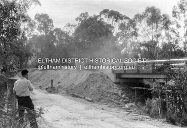
Negative - Photograph, J.A. McDonald, Henley Road at Watsons Creek, Apr. 1961
... Pelling Henley Road Henley Road Bridge Kangaroo Ground Oxley ...Henley Road at Watsons Creek looking westerly showing west abutment excavation Mid April 1961Record of various Shire of Eltham infrastructure works undertaken during the period of 1952-1962 involving bridge and road reconstruction projects, sometimes with Eltham Shire Council Project Reference numbers quoted. It was during this period that a number of significant improvements were made to roads and new bridges constructed within the shire that remain in place as of present day (2022). In many situations, the photos provide a tangible visible record of infrastructure that existed throughout the early days of the Shire. The album was put together by or under the direction of the Shire Engineer, J.A. McDonald.infrastructure, shire of eltham, bend of islands, cr. charis pelling, henley road, henley road bridge, kangaroo ground, oxley bridge, watsons creek, w.e. wolf, bridge construction, road construction, 1961-04 -
 Eltham District Historical Society Inc
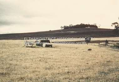
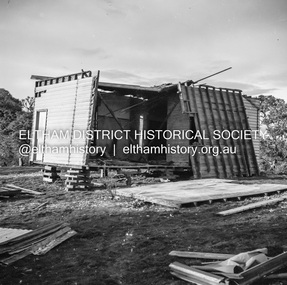
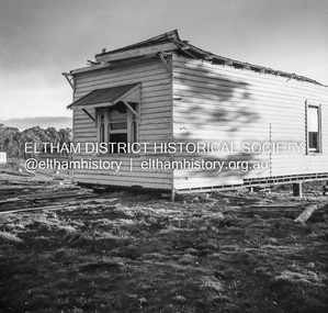
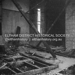
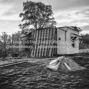
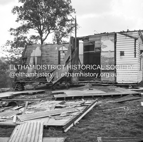
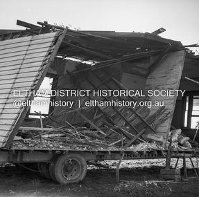
Negative - Photograph, J.A. McDonald, Inspection of storm damaged Abraham house at Kangaroo Ground, c. May 1962
Showing the effect of a wind storm that destroyed the house circa May 1962.. The Abraham family owned land near the Aqueduct and east of Nicholas Lane at Kangaroo Ground (based on photos, at or near 40 Nicholas Lane).Record of various Shire of Eltham infrastructure works undertaken during the period of 1952-1962 involving bridge and road reconstruction projects, sometimes with Eltham Shire Council Project Reference numbers quoted. It was during this period that a number of significant improvements were made to roads and new bridges constructed within the shire that remain in place as of present day (2022). In many situations, the photos provide a tangible visible record of infrastructure that existed throughout the early days of the Shire. The album was put together by or under the direction of the Shire Engineer, J.A. McDonald.1962-05, abraham house, kangaroo ground, nicholas lane, property damage, storm damage -
 Eltham District Historical Society Inc
Negative - Photograph, J.A. McDonald, Inspection of storm damaged Abraham house at Kangaroo Ground, c. May 1962
Showing the effect of a wind storm that destroyed the house circa May 1962.. The Abraham family owned land near the Aqueduct and east of Nicholas Lane at Kangaroo Ground (based on photos, at or near 40 Nicholas Lane).Record of various Shire of Eltham infrastructure works undertaken during the period of 1952-1962 involving bridge and road reconstruction projects, sometimes with Eltham Shire Council Project Reference numbers quoted. It was during this period that a number of significant improvements were made to roads and new bridges constructed within the shire that remain in place as of present day (2022). In many situations, the photos provide a tangible visible record of infrastructure that existed throughout the early days of the Shire. The album was put together by or under the direction of the Shire Engineer, J.A. McDonald.1962-05, abraham house, kangaroo ground, nicholas lane, property damage, storm damage, building surveyor, george e. newton -
 Eltham District Historical Society Inc
Negative - Photograph, J.A. McDonald, Inspection of storm damaged Abraham house at Kangaroo Ground, c. May 1962
Showing the effect of a wind storm that destroyed the house circa May 1962.. The Abraham family owned land near the Aqueduct and east of Nicholas Lane at Kangaroo Ground (based on photos, at or near 40 Nicholas Lane).Record of various Shire of Eltham infrastructure works undertaken during the period of 1952-1962 involving bridge and road reconstruction projects, sometimes with Eltham Shire Council Project Reference numbers quoted. It was during this period that a number of significant improvements were made to roads and new bridges constructed within the shire that remain in place as of present day (2022). In many situations, the photos provide a tangible visible record of infrastructure that existed throughout the early days of the Shire. The album was put together by or under the direction of the Shire Engineer, J.A. McDonald.1962-05, abraham house, kangaroo ground, nicholas lane, property damage, storm damage -
 Eltham District Historical Society Inc
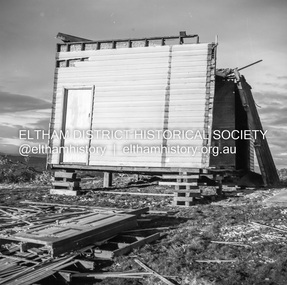
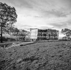
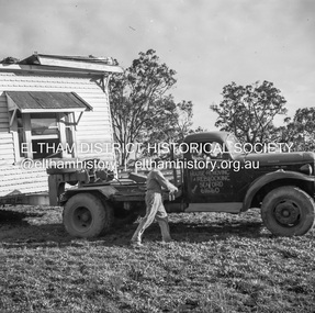
Negative - Photograph, J.A. McDonald, Removal of the remains of the Abraham house at Kangaroo Ground, c. May 1962
Martin Bros House Removing of Seaford was contracted to remove the remains of the storm damaged Abraham house from the property circa May 1962. The Abraham family owned land near the Aqueduct and east of Nicholas Lane at Kangaroo Ground (based on photos, at or near 40 Nicholas Lane).Record of various Shire of Eltham infrastructure works undertaken during the period of 1952-1962 involving bridge and road reconstruction projects, sometimes with Eltham Shire Council Project Reference numbers quoted. It was during this period that a number of significant improvements were made to roads and new bridges constructed within the shire that remain in place as of present day (2022). In many situations, the photos provide a tangible visible record of infrastructure that existed throughout the early days of the Shire. The album was put together by or under the direction of the Shire Engineer, J.A. McDonald.1962-05, abraham house, kangaroo ground, martin bros house removing seaford, nicholas lane, property damage -
 Eltham District Historical Society Inc
Negative - Photograph, J.A. McDonald, Removal of the remains of the Abraham house at Kangaroo Ground, c. May 1962
Martin Bros House Removing of Seaford was contracted to remove the remains of the storm damaged Abraham house from the property circa May 1962. The Abraham family owned land near the Aqueduct and east of Nicholas Lane at Kangaroo Ground (based on photos, at or near 40 Nicholas Lane).Record of various Shire of Eltham infrastructure works undertaken during the period of 1952-1962 involving bridge and road reconstruction projects, sometimes with Eltham Shire Council Project Reference numbers quoted. It was during this period that a number of significant improvements were made to roads and new bridges constructed within the shire that remain in place as of present day (2022). In many situations, the photos provide a tangible visible record of infrastructure that existed throughout the early days of the Shire. The album was put together by or under the direction of the Shire Engineer, J.A. McDonald.1962-05, abraham house, kangaroo ground, martin bros house removing seaford, nicholas lane, property damage