Showing 1290 items
matching lands
-
 Federation University Historical Collection
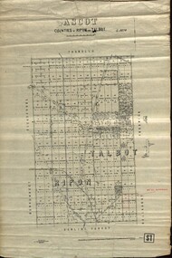
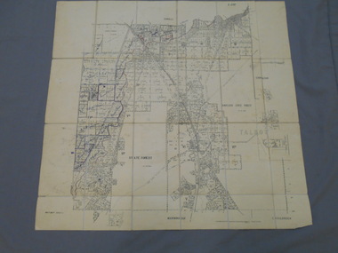
Plan - map, Ascot: Counties of Ripon and Talbot, 18/12/1920
Cadastral map showing parish boundaries and land ownership. "L5270"Maps parishes located in Ascot area. Photo-Lithographed at the Dept. of Lands and Survey.Highlighted parish labelled, Mrs E.C.Sutherland.parish, map, ascot, counties, e. c. sutherland, a. cameron, sweeney, w. j. clarke, mount hollowback, tourello, burrumbeet, glendaruel, dowling forest, a. j. mullett, w. j. butson, 1920, william coghill, chatham, chatham family collection, mrs e.c.sutherland. -
 Port Melbourne Historical & Preservation Society
Letter - Lands & Survey Office re land for football ground, 19 Apr 1880
Letter from Lands & Survey Office regarding land for football ground, 1880sport - australian rules football, sport - recreational grounds, peter gallienne grut, port melbourne football club, pmfc -
Port Melbourne Historical & Preservation Society
Plan - Football Ground, Department of Survey & Lands, 13 May 1880
Plan for Football Ground on land being granted by Department of Survey & Lands, 1880sport - australian rules football, sport - recreational grounds, j kitchen & sons pty ltd, port melbourne football club, pmfc -
 Whitehorse Historical Society Inc.
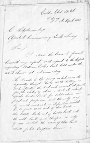
Letter - Document, Roads, 1/04/1868
Letter to C. Hodgkinson, Assistant Commissioner of Lands Survey from William H. Watkins, Bailiff of Crown Lands, dated 1 April 1868 re alternative locations of road through Messrs Cook or Cummings land in Nunawading.marshall's gully, cook, william, cumming (mr), watkins, william h, hodgkinson, clement, roads and streets -
 Bendigo Historical Society Inc.
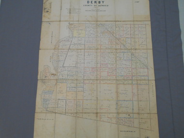
Map - JACK FLYNN COLLECTION: DERBY, 12/05/1892
Map: Derby, County of Bendigo. Parish plan.Department of Lands and Survey Melbourne by T.F.McGauran, 12.5.92map, bendigo, parish plan, derby -
 Bendigo Historical Society Inc.
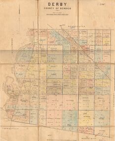
Map - JACK FLYNN COLLECTION: DERBY, 1/09/1909
Map: Derby, County of Bendigo. Parish plan.Dept of Lands and Survey, Melbourne by T.E.McGauran 1.9.09map, bendigo, parish plan, derby -
 Bendigo Historical Society Inc.
Map - JACK FLYNN COLLECTION: BET BET SHEET 2, 17/09/1931
Map: Parish of Bet Bet Sheet 2. Parish plan.Photo Lithographed at the Lands and Survey Melbourne. 17.9.31map, gladstone, parish plan, bet bet -
 Bendigo Historical Society Inc.
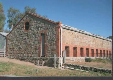
Photograph - RAVENSWOOD CROWN LANDS
Colour Photograph, Ravenswood Crown Lands, an end view of the shearing shed with the yard on right.photograph, building, ravenswood estate -
 Bendigo Historical Society Inc.
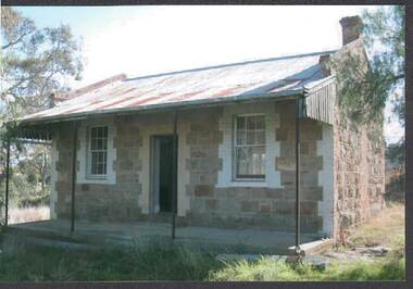
Photograph - RAVENSWOOD CROWN LANDS
Colour Photograph, Ravenswood Crown Lands, Front view of the cottage which has a verandah.photograph, building, ravenswood estate -
 Bendigo Historical Society Inc.
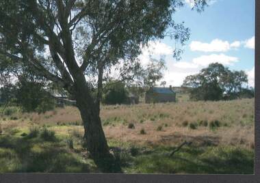
Photograph - RAVENSWOOD CROWN LANDS
Colour Photograph, Ravenswood Crown Lands, 3 buildings amongst the trees on the Ravenswood Estate.photograph, building, ravenswood estate -
 Bendigo Historical Society Inc.
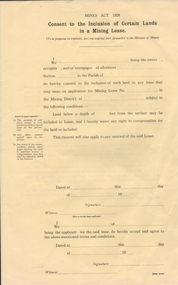
Document - CONSENT TO THE INCLUSIION OF CERTAIN LANDS IN A MINING LEASE
Mines Act 1928. Consent to the inclusion of certain lands in a mining lease. Blank form.business, mining, application -
 Clunes Museum
Photograph
LANDS DEPARTMENT COLOURED PHOTOGRAPH - CLEARING AREA ALONG CREEK TO MAKE PICNIC AREAlocal history, photography, photographs, clunes landscape -
Whitehorse Historical Society Inc.
Document, Division of Survey and Mapping, 1984
A brief guide to Crown Lands And Survey records commonly used for family history research.A brief guide to Crown Lands And Survey records commonly used for family history research.A brief guide to Crown Lands And Survey records commonly used for family history research.crown lands, victorian government, land surveys -
 Ringwood and District Historical Society
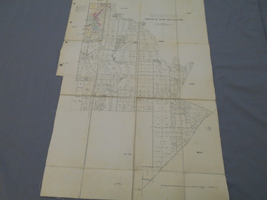
Document - Map, Plan of Subdivision - Part of Crown Allotments 14A & 14C, Parish of Ringwood, County of Mornington, Vol 5378 Fol 511 - 1927
Department of Lands and Survey photocopy dated 17/1/1951, page number 12308.Map includes Canterbury Road, Heathmont Road, Dickasons Road, Bennett Avenue, Orchid Street and Allens Road, Heathmont, Vic. -
Clunes Museum
Map - PLAN / MAP
.1 MAP, TOWN OF CLUNES, PARISH OF CLUNES, COUNTY OF TALBOT, STAMPED BOROUGH OF CLUNES .2 PLAN OF SUBDIVISION OF PART OF CLUNES COMMON, BOROUGH OF CLUNES, PARISH OF CLUNES,COUNTY OF TALBOT. P. CAMPBELL. ASSISTANT SURVEYOR, MARCH 1904 ON RIGHT HAND BOTTOM CORNER C71/1 CLUNES COMMON. MARKED: CHARTED R.L.A.7/2/57.1 PHOTO LITHOGRAPHED. DEPARTMENT OF LANDS AND SURVEY, MELBOURNE .2 PHOTO LITHOGRAPHED AT THE DEP. OF LANDS AND SURVEY, MELBOURNE PRICE 1/- 10.11.08map town of clunes, borough of clunes, parish of clunes, county of talbot -
 Orbost & District Historical Society
Book - front cover, The Corringle Creek to Sydenham Inlet Coastal Reserve A RESOURCES STUDY, 1977
This 1977 Resources Study was a joint project of the Shire of Orbost & the Dept. of Crown Lands & Survey with the purpose of collating information on natural resources, pattern of public use, and constraints on future use so that management can be formulated.This report gives and understanding of the resources and management directions of coastal land in East Gippsland in 1977. A buff coloured cover with black printing and blue tape binding. 71 pages + maps/charts. THE CORRINGLE CREEK TO SYDENHAM INLET COASTAL RESERVE. A resources study with comment on the implications for management by IAN R. BROWN Research officer and PETER B. LAVERY Land Management Oficer. Coastal management Committee Victoria 1977. Published under the authority of the Coastal Management Committee by the Department of Crown Lands and Survey, Victoria 1977. Printed by James Yeates Printing, Bairnsdale 3875.corringle creek, sydenham inlet, natural resources survey -
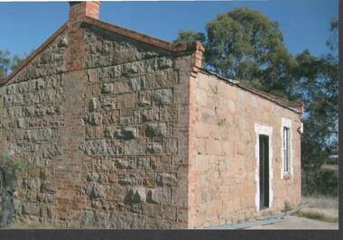 Bendigo Historical Society Inc.
Photograph - RAVENSWOOD CROWN LANDS
Colour Photograph, Ravenswood Crown Lands, Back and side view of a cottage with a man examining the wall.photograph, building, ravenswood estate -
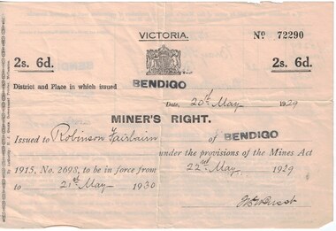 Bendigo Historical Society Inc.
Document - Mining in Bendigo, 1909 to 1939
BHS CollectionDocuments related to Mining in Bendigo, purchase of a property. 8663.3a Front of Miners Right issued to Robinson Fairbairn 8663.3b Back of Miners Right issued to Robinson Fairbairn 8663.3c Valuation from Shire of Marong, 14 Bray St., California Gully 8663.3d Receipt from the Lands Department and Closer settlement Commission 8663.3e Receipt from the Lands Department and Closer settlement Commission 8663.3f Receipt from the Lands Department and Closer settlement Commission 8663.3g Receipt from the Lands Department 8663.3h Receipt from Albert E. Brown Land and Stock Agenthistory, mining, robinson fairbairn collection, miners right, victorian lands department and closer settlement commission, albert e brown land and stock agent -
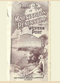 Ringwood and District Historical Society
Memorabilia, Tourist Map of Mornington Peninsula and Western Port - 1929
Multi-fold pictorial map of towns, railways and main roads east of Port Phillip Bay from Melbourne to Yarra Junction and south to Phillip Island and Wonthaggi, backed by details of main features and points of interest.Photo-Lithographed by Department of Lands and Survey, Melbourne, 2.8.1929. -
 Bendigo Historical Society Inc.
Map - JACK FLYNN COLLECTION: EDDINGTON, 1.12.1925
Map: Parish of Eddington, Counties of Gladstone and Talbot. Parish plan.Dept of Lands and Survey Melbourne by W.J. Butson 1.12.25map, talbot, parish plan, eddington, counties of talbot, gladstone -
 Bendigo Historical Society Inc.
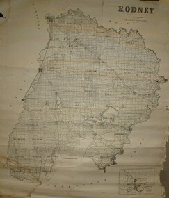
Map - JACK FLYNN COLLECTION: RODNEY, Revised in 1935
Map: County of Rodney, map sheet showing the whole of the County of Rodney and all of the Parishes within.Drawn at the Department of Lands and Survey, Melbourne. Revised to 1935map, rodney, parish plan, rodney -
 Department of Energy, Environment and Climate Action
Motorola Syntax radio
After the 1939 bushfires, the Forests Commission Victoria invested heavily in a radically new communications network. After suffering some inevitable delays due to the war, radio VL3AA switched into full operation in October 1945 proudly beaming out 200 watts across the State. But by today’s standards, the technology was primitive and the reception poor unless the user was on a high point somewhere. The radio signal was "line-of-sight" and bounced between fire towers and relay transmitters across the mountains back to the District offices. The advent of solid-state electronics in the 1960s replaced the more delicate valve sets which enabled greater use of vehicle mounted radios. The Commission continued to research, develop and build new radios at its many workshops around Victoria. The network was supported by a large team of skilled radio technicians. The more secure and versatile State Mobile Radio (SMR) digital trunk system came into operation in about 1995. Upgraded Tait Radios were purchased in 2014 after recommendations of the 2009 Bushfires Royal Commission. But it was the convergence of separate technologies such as 5G mobile phones, high-capacity and light-weight lithium batteries, Wi-Fi, the ever-expanding internet, cloud data storage, digital cameras, GPS, personal organisers and hundreds of supporting Apps into powerful smartphones and tablets which revolutionised bushfire communications from the mid-2000s. Radio with handsetConservation Forests and Lands Colac Region 09/209bushfire, radios, forests commission victoria (fcv) -
 Ringwood and District Historical Society
Map, Allotments - Township of Ringwood - Parish of Ringwood - County of Mornington - 1886, 1886
[Page 3, Horse Shoes to High Heels - Richard Carter] ... "(In the year 1882) the railway was extended from Hawthorn through Ringwood to Lilydale and later to Ferntree Gully." Linen-backed map of Ringwood area lithographed at the Department of Lands and Survey, Melbourne, 5th November, 1886.old lilydale road, new lilydale road, victoria brick and tile co., ringwood brick co., federal brick co. -
Bendigo Historical Society Inc.
Map - LANDS AVAILABLE FOR SELECTION, 6/05/1912
Map: Lands available for selection, County of Bendigo. Parish plan ( number 192 in Map Cupboard 1)map, bendigo, lands available for selection, lands available for selection, bendigo -
 Whitehorse Historical Society Inc.
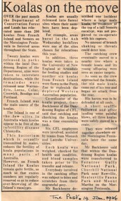
Article, Koalas on the move, 14/01/1986 12:00:00 AM
Article from 'The Post' 14 January 1986 about relocation of koalas by the Department of Conservation, Forests and Lands.Article from 'The Post' 14 January 1986 about relocation of koalas by the Department of Conservation, Forests and Lands.Article from 'The Post' 14 January 1986 about relocation of koalas by the Department of Conservation, Forests and Lands.wildlife, koalas, victoria. department of conservation forests and lands -
 Ringwood and District Historical Society
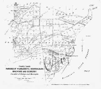
Photograph, Map-Parishes of Warrandyte, Mooroolbark, Ringwood and Scoresby. 1870
Photograph of map "Country Lands - Parishes of Warrandyte, Mooroolbark, Ringwood and Scoresby - Counties of Evelyn and Mornington" dated 1870. -
Bendigo Historical Society Inc.
Map - CALAVIL, 28/08/1874
Map: Country Lands, Parish of Calavil, County of Bendigo. Parish plan (number 334 in map cupboard 1)map, bendigo, country lands, country lands, parish of calavil -
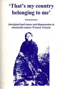 Victorian Aboriginal Corporation for Languages
Book, Ian D Clark, That's my country belonging to me : Aboriginal land tenure and dispossession in nineteenth century Western Victoria, 1998
Investigating the dispossession of Aboriginal people from their lands in Western Victoria. The methods of dispossession (exclusion etc.) and restrictions, with the consequences of this.maps, tables, b&w photographsdjab wurrung, dhauwurd wurrung, bargundidj, djadja wurrung, djagurd wurrung, gadubanud, girai wurrung, gulidjan, jardwadjali, watha wurrung, wergaia, western victoria, land tenure -
Whitehorse Historical Society Inc.
Map, Nunawading - Deep Creek, 1868
Map of Nunawading - Deep Creek area On verso: Copy of map with letter to Minister of Lands and Works. 1868 [ND 933]Map of Nunawading - Deep Creek area On verso: Copy of map with letter to Minister of Lands and Works. 1868 [ND933]Map of Nunawading - Deep Creek area On verso: Copy of map with letter to Minister of Lands and Works. 1868 [ND 933]maps, mitcham -
Whitehorse Historical Society Inc.
Document, Crown Grant Register, 10/05/1999
Crown Grant Register - General Law - Parish of Nunawading, 1854 - 1858. Lands Department plan of Parish, 1864.land settlement, victoria. lands department, blood, robert, blood, thomas, burrell, charles, clisby, william, cook, charles, cousens, james, dickensen, william, harding, william, hedding, william, holland, john, jones, william, kefford, richard, lobb, john, morgan, robert rowland, morton, william, o'conner, patrick, orr, joseph, polak, nelson, riley, patrick, smith, l l dr, tranter, william, whitman, francis, williams, william, wilks, joseph, wilson, william, wilton, edward