Showing 379 items
matching main road montmorency
-
 Eltham District Historical Society Inc
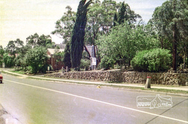
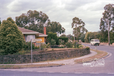
Photograph, Eltham RSL and Uniting Church, Main Road, Eltham, c.1979, 1979c
Changing streetscape - RSL branch merged with Montmorency. Land sold and since developed into units.Roll of 35mm colour negative film, 6 stripsUnidentified; half-frame numberingmonuments, church, eltham rsl sub-branch, eltham uniting church, main road -
 Eltham District Historical Society Inc
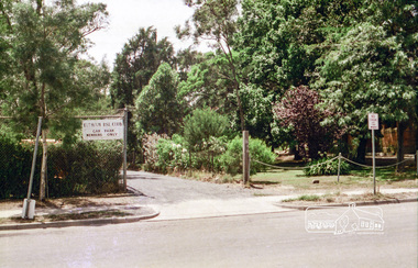
Photograph, Eltham RSL carpark entrance, Pitt Street, Eltham, c.1979
Changing streetscape - RSL branch merged with Montmorency. Land sold and since developed into units.Roll of 35mm colour negative film, 6 stripsUnidentified; half-frame numberingmonuments, church, eltham rsl sub-branch, eltham uniting church, main road -
 Eltham District Historical Society Inc
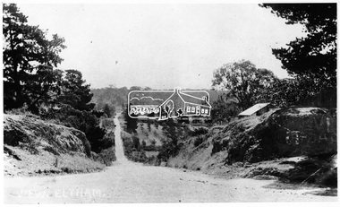
Negative - Photograph, Bridge Street, Eltham, c.1910
View from Maria Street (Main Road) along Bridge Street, Eltham, looking towards Montmorency. The house on the right at the corner of Susan and Bridge streets was owned for many years by the Hill family until Council bought it in the early 1960s. The house was built in the 1850s or 60s. The house on the left stood on what is now the southwest corner of Susan and Bridge Streets. The Braithwaite family was associated with this house. Orchards in the foreground either side of the Diamond Creek. The line of trees running up the hill to the left represents the Bolton street alignment. Based on hand writing of title on image compared with others, date is estimated at c.1910.This photo forms part of a collection of photographs gathered by the Shire of Eltham for their centenary project book,"Pioneers and Painters: 100 years of the Shire of Eltham" by Alan Marshall (1971). The collection of over 500 images is held in partnership between Eltham District Historical Society and Yarra Plenty Regional Library (Eltham Library) and is now formally known as the 'The Shire of Eltham Pioneers Photograph Collection.' It is significant in being the first community sourced collection representing the places and people of the Shire's first one hundred years.Digital image 4 x 5 inch B&W Negshire of eltham pioneers photograph collection, bolton steet, braithwaite, bridge, bridge street, bridge street bridge, eltham, hill family home, susan street, orchards -
 Eltham District Historical Society Inc
Negative - Photograph, George W. Bell, Excavation of site for new Eltham Shire Office building, 895 Main Road, Eltham, 1964
Black and white photograph of bulldozer excavating the former Shillinglaw Cottage site for new Shire Offices. 'Shillinglaw Trees' in background. The cottage and land were purchased by the Shire of Eltham as the site for a new shire office building. The cottage was destined for demolition but members of the community concerned at losing one of the areas earliest buildings (built c.1859) initiated a fund-raising campaign to save the cottage. In 1964 the cottage was dis-assembled, all the bricks numbered and reassembled several hundred meters to the south on a site between the Gahan house and the Eltham Railway Trestle Bridge (present-day Panther Place), which became known as the Eltham Common. The new shire offices at 895 Main Road were opened in 1965. Following the Kennett Government amalgamation of local government areas in 1994, the Shire of Eltham ceased to exist, and a new Shire of Nillumbik was created 15 December 1994 from the former Eltham shire and parts of the Diamond Valley shire. The former West Riding which included parts of Montmorency, Lower Plenty and Briar Hill were ceded to the new City of Banyule. Commissioners were appointed for several years and the new Council occupied the former offices of the Shire of Diamond Valley in Greensborough. The former Eltham Shire offices remained vacant until August 1996 the Commissioners suddenly elected to have the former Shire offices demolished immediately and the site has remained vacant ever since. It was not until 1997 before the community was allowed to democratically elect new Councillors to represent them. This photo forms part of a collection of photographs gathered by the Shire of Eltham for their centenary project book,"Pioneers and Painters: 100 years of the Shire of Eltham" by Alan Marshall (1971). The collection of over 500 images is held in partnership between Eltham District Historical Society and Yarra Plenty Regional Library (Eltham Library) and is now formally known as the 'The Shire of Eltham Pioneers Photograph Collection.' It is significant in being the first community sourced collection representing the places and people of the Shire's first one hundred years.Digital image 4 x 5 inch B&W Negeltham, eltham shire office, excavation, george w. bell collection, main road, municipal offices, shillinglaw cottage, shillinglaw trees, shire of eltham pioneers photograph collection, shire offices, significant tree -
 Eltham District Historical Society Inc
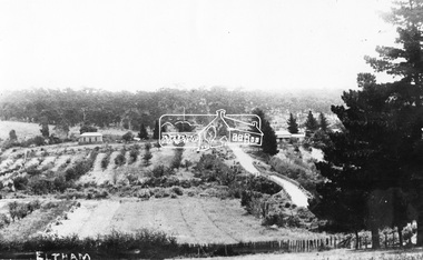
Negative - Photograph, View, Bridge Street, Eltham, c.1890
... View towards Montmorency Estate from Main Road, Eltham... melbourne View towards Montmorency Estate from Main Road, Eltham ...View towards Montmorency Estate from Main Road, Eltham about 1890. Looking down Bridge Street across the bridge (1875). At the corner of Susan Street is the Hill family home. Reproduced in "Montmorency; the farm on the Plenty" by Maureen Jones, 2015, p43 - 'View towards Montmorency Estate from main Road, Eltham, c.1890'This photo forms part of a collection of photographs gathered by the Shire of Eltham for their centenary project book,"Pioneers and Painters: 100 years of the Shire of Eltham" by Alan Marshall (1971). The collection of over 500 images is held in partnership between Eltham District Historical Society and Yarra Plenty Regional Library (Eltham Library) and is now formally known as 'The Shire of Eltham Pioneers Photograph Collection.' It is significant in being the first community sourced collection representing the places and people of the Shire's first one hundred years.Digital image 4 x 5 inch B&W Negshire of eltham pioneers photograph collection, eltham, bridge street, bridge street bridge, hill family home, montmorency, susan street -
 Eltham District Historical Society Inc
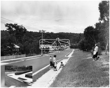
Photograph, Shire of Eltham, Montmorency - Calrossie Avenue (newly constructed road and footpaths), November 1966
New paved road, footpaths and gutters on Calrossie Avenue, Montmorency.This photo forms part of a collection of photographs gathered by the Shire of Eltham for their centenary project book, "Pioneers and Painters: 100 years of the Shire of Eltham" by Alan Marshall (1971). The collection of over 500 images is held in partnership between Eltham District Historical Society and Yarra Plenty Regional Library (Eltham Library) and is now formally known as 'The Shire of Eltham Pioneers Photograph Collection.' It is significant in being the first community sourced collection representing the places and people of the Shire's first one hundred years.Digital imagesepp, shire of eltham pioneers photograph collection, montmorency, calrossie avenue, road construction, footpaths -
 Eltham District Historical Society Inc
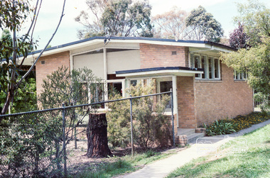
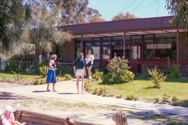
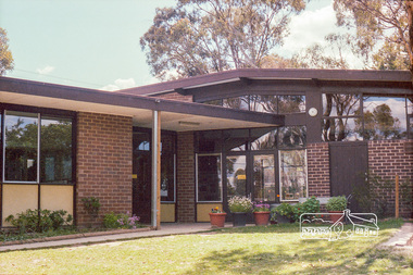
Photograph, Marjorie North, Pre-school and Infant Welfare Centre at rear of Petrie Park, Mountain View Road, Montmorency, Jan 1986, 1986
Negatives supplied by Marjorie North 1 July 1986 for Montmorency France albumRoll of 35mm colour negative film, 4 of 6 stripsKodak CP 100 5094montmorency, petrie park, petrie park hall, infant welfare centre, mountain view road -
 Eltham District Historical Society Inc
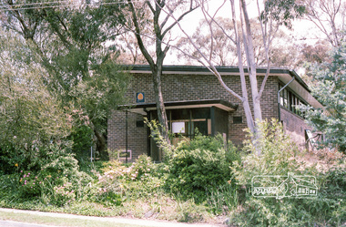
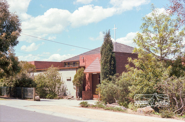
Photograph, Marjorie North, Uniting Church front porch, Mountain View Road, Montmorency, Jan 1986, 1986
Negatives supplied by Marjorie North 1 July 1986 for Montmorency France albumRoll of 35mm colour negative film, 4 of 6 stripsKodak CP 100 5094montmorency, petrie park, petrie park hall, mountain view road, uniting church -
 Eltham District Historical Society Inc
Photograph, Marjorie North, Ansell and Muir's Chicken shop, Main Road, Eltham South, 1985-1986, 1986
Negatives supplied by Marjorie North 1 July 1986 for Montmorency France albumRoll of 35mm colour negative film, 4 of 6 stripsKodak CP 100 5094ansell, bridge, diamond creek, eltham gallery, eltham lower park, eltham park tea room, eltham south, falkiner street, muir -
 Eltham District Historical Society Inc
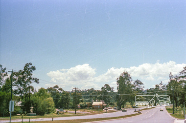
Photograph, Marjorie North, Montmorency Shopping Centre sign, corner of Rattray and Looker Roads, 8 Feb 1986, 1986
Negatives supplied by Marjorie North 1 July 1986 for Montmorency France albumRoll of 35mm colour negative film, 4 of 6 stripsKodak CP 100 5094montmorency, looker road, rattray road, shopping centre -
 Eltham District Historical Society Inc
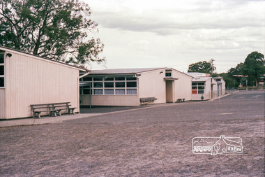
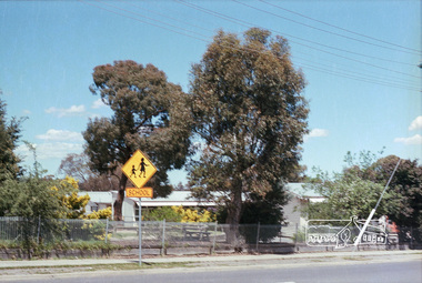
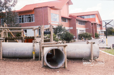
Photograph, Marjorie North, Rear view of Montmorency State Primary School looking towards Rattray Road, 8 Feb 1986, 1986
Negatives supplied by Marjorie North 1 July 1986 for Montmorency France albumRoll of 35mm colour negative film, 4 of 6 stripsKodak CP 100 5094montmorency, rattray road, montmorency state primary school -
 Eltham District Historical Society Inc
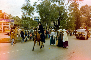
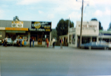
Photograph, Ruth H. Pendavingh, Eltham Festival, Main Road, Eltham
... melbourne eltham festivals main road lyon bros ford montmorency ...Three colour photographs near the corner of Arthur Street and Main Road; two looking diagonally across Main Road, Eltham towards Lyon Bros Ford dealership showing the general Festival parade; one looking directly across Main Road showing Real Estate agency (photo blurred from movement but gives a general perspective of the scene). Parade participants include Montmorency Primary School. Eltham High Schooleltham, festivals, main road, lyon bros ford, montmorency primary school, eltham high school -
 Eltham District Historical Society Inc
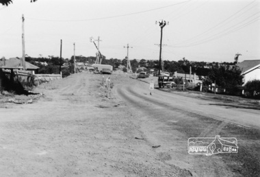
Photograph, Sherbourne Road bridge construction works over railway line, Montmorency, c.1971, 1971c
Black and white photograph printeltham, sherbourne road, railway bridge, construction, montmorency -
 Eltham District Historical Society Inc
Photograph, Marjorie North, Montmorency Tennis Club, Dobson Road, Montmorency, 1985, 1985
Negatives supplied by Marjorie North 1 July 1986 for Montmorency France albumRoll of 35mm colour negative film, 3 stripsKodak CL 200 5093dobson road, montmorency, montmorency tennis club -
 Eltham District Historical Society Inc
Photograph, Marjorie North, Montmorency State Primary School facing Rattray Road, 1985, 1986
Negatives supplied by Marjorie North 1 July 1986 for Montmorency France albumRoll of 35mm colour negative film, 3 stripsKodak CL 200 5093montmorency, montmorency state primary school, rattray road -
 Eltham District Historical Society Inc
Photograph, Marjorie North, Anglican Church St Faiths, Mountain View Road, Montmorency, 1985, 1986
Negatives supplied by Marjorie North 1 July 1986 for Montmorency France albumRoll of 35mm colour negative film, 3 stripsKodak CL 200 5093montmorency, st faiths anglican church, mountain view road -
 Eltham District Historical Society Inc
Photograph, Marjorie North, St Francis Xavier Parish Church, Mayona Road, Montmorency, 1985, 1986
Negatives supplied by Marjorie North 1 July 1986 for Montmorency France albumRoll of 35mm colour negative film, 3 stripsKodak CL 200 5093montmorency, st francis xavier parish, mayona road, church -
 Eltham District Historical Society Inc
Photograph, Marjorie North, St Francis Xavier Catholic Primary School, at rear of church, Mayona Road, Montmorency, 1985, 1986
Negatives supplied by Marjorie North 1 July 1986 for Montmorency France albumRoll of 35mm colour negative film, 3 stripsKodak CL 200 5093montmorency, st francis xavier parish, mayona road -
 Eltham District Historical Society Inc
Photograph, Marjorie North, Uniting Church Hall and Kindergarten complex, Mountain View Road, Montmorency, 1986
Negatives supplied by Marjorie North 1 July 1986 for Montmorency France albumRoll of 35mm colour negative film, 3 stripsKodak CL 200 5093montmorency, mountain view road, uniting church -
 Eltham District Historical Society Inc
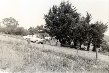
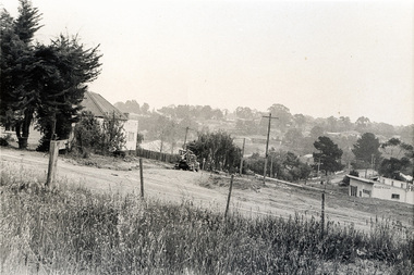
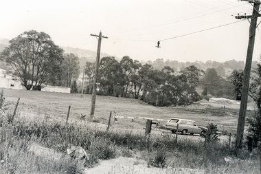
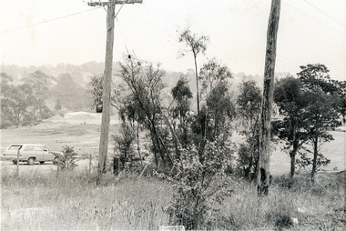
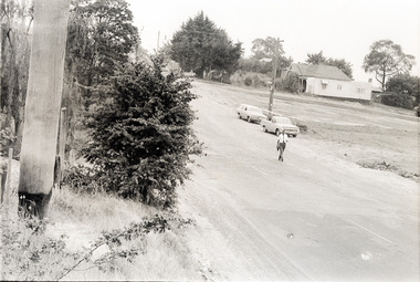
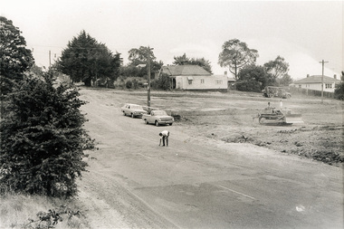
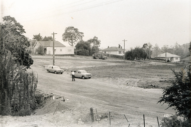
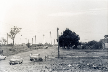
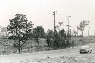
Photograph, Sherbourne Road, Para Road and Simms Road at Briar Hill/Montmorency prior to the upgrade of Sherbourne Road Railway bridge, c.1970
Collection of photographs probably taken around the same time depicting Sherbourne Road, Para Road and Simms Road at Briar Hill/Montmorency prior to the upgrade of Sherbourne Road Railway bridge, c.1970. Photo 01648_ 19 This home owned by Mrs Cameron. Her daughter married a Mr Davey, for whom Davey Road was named - email from M. Jones 20/07/2015 Photographer unknownThese photos are very significant in the documentation of the development of the Briar Hill and Montmorency areas and the changes in the physical landscape along the railway line area.20 black and white prints 9 cm x 13 cm.1970, briar hill, davey road, montmorency, para road, cameron, davey, sherbourne road, simms road, railway line, roadworks -
 Eltham District Historical Society Inc
Photograph, Sherbourne Road, Para Road and Simms Road at Briar Hill/Montmorency prior to the upgrade of Sherbourne Road Railway bridge, c.1970
Collection of photographs probably taken around the same time depicting Sherbourne Road, Para Road and Simms Road at Briar Hill/Montmorency prior to the upgrade of Sherbourne Road Railway bridge, c.1970. Photo 01648_ 19 This home owned by Mrs Cameron. Her daughter married a Mr Davey, for whom Davey Road was named - email from M. Jones 20/07/2015 Photographer unknownThese photos are very significant in the documentation of the development of the Briar Hill and Montmorency areas and the changes in the physical landscape along the railway line area.20 black and white prints 9 cm x 13 cm.1970, briar hill, davey road, montmorency, para road, cameron, davey, sherbourne road, simms road, railway line, roadworks