Showing 631 items
matching mine shafts
-
 Bendigo Historical Society Inc.
Document - ALBERT RICHARDSON COLLECTION: EARLY HISTORY OF THE BENDIGO GOLDFIELD
Typed foolscap two sided document with information about the early history of the Bendigo Goldfield. Topics include the first gold discovery, how gullies were worked, quartz reefing, gold cakes, hand dollies and Chilian mills. Some brief statistics of the Bendigo goldfield include the total gold yield of 17,370,561 ounces plus 5,000,000 oz sold outside Bendigo. The greatest depth reached by any mine in the State, 4,593 feet below surface, or 3,700 feet below sea-level, was attained by the Victoria Quartz Company. About 100 shafts exceed a depth of 1,000 feet, of which 40 are between 2,000 and 3,000 feet deep, fifteen are between 3,000 and 4,000 feet and two are over 4,000 feet.bendigo, mining, mines department -
 Bendigo Historical Society Inc.
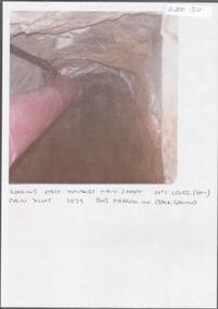
Photograph - KEN BICE COLLECTION: WATTLE GULLY GOLD MINE
Colour photograph, faded and laminated. Image shows an underground tunnel with air/electricity wiring on LH side of decline. Written on bottom : looking east towards main shaft. No. 1 level (60m) main xcut 1979. Bob Farrell in background'mining, underground equipment, wattle gully gold mine -
 Bendigo Historical Society Inc.
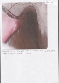
Photograph - KEN BICE COLLECTION: WATTLE GULLY GOLD MINE
Laminated, faded colour photograph. Image shows stope with air lines. On bottom of image: ' looking east towards main shaft No. 1 level, Wattle Gully Mine 1979'mining, equipment, wattle gully gold mine -
 Bendigo Historical Society Inc.
Document - ALBERT RICHARDSON COLLECTION: THE PEARL MINE
Typed, 2 page document, detailing the location and history of the operation of the Pearl Mine. The mine was located approximately 2 miles north west from the Bendigo Post Office. The main shaft was put down to 1613 feet and 3 subsidiary shafts were sunk, Information is given about the south shaft, originally the main shaft of the Great Extended Hercules and the east shaft, which was situated on the Sheepshead line.bendigo, mining, pearl company mine -
 Bendigo Historical Society Inc.
Map - MAP: VIRGINIA MINE GARDEN GULLY LINE OF REEF
Map of Virginia Mine on the Garden Gully line of reef, Eaglehawk, transverse section. Shaft, levels and Garden Gully anticlinal axial line drawn. Key shows types of formations - quartz, spurs, sandstone, slate, cleavage, lava. This map forms part of the Geological Survey of Victoria, Structure of Bendigo Goldfield report, No. 47, 1923. H.Herman, late Director of Geological Survey.Geological Survey Victoria, Geological Survey Office, Bendigo.bendigo, gold mining, virgina mine eaglehawk, eaglehawk, bendigo, gold mining, virginia mine, garden gully line of reef. -
Bendigo Historical Society Inc.
Map - MINE LOCATION DRAWING AT VICTORIA HILL
Claims and shafts location for: Rae and co. - Noye and co. - Wittscheibe. Some additions to drawing made in pencil.mining, business -
 Bendigo Historical Society Inc.
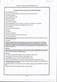
Document - GLASGOW AND GOLCONDA CONSOLIDATED GOLD MINE
Information regarding the Glasgow and Golconda Consolidated Gold Mine, Golden Gully. Mine is on the Napoleon Reef, shaft depth of 800 ft. A description of the physical remains is given and the significance of the site is described. It is the only site in Bendigo 'which retains evidence of the tramway between the mine and the battery site'bendigo, mining, glasgow golconda mine site -
 Bendigo Historical Society Inc.
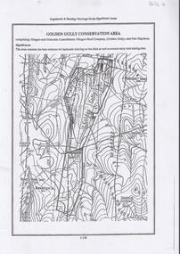
Document - DIAMOND HILL, GOLDEN GULLY COSERVATION AREA
Map of Golden Gully conservation area comprising Glasgow and Golconda Consolidated, Glasgow Reef Company (Golden Gully) and New Napoleon. The area is significant because it contains the 'best evidence for hydraulic sluicing on the field as well as several early reef mining sites' On top of page 'Eaglehawk & Bendigo Heritage Study, Significant areas' Mines marked on page: Goldfields Extended shaft South Concord shaft Concord shaft Morning Light shaft Hansel and Mundy shaftbendigo, mining, golden gully -
Bendigo Historical Society Inc.
Document - NEW CHUM LINE OF REEF - REFERENCE FOR CALEB THOMAS PLANS
Two handwritten pages of reference numbers for Caleb Thomas plans. The numbers refer to mines on the New Chum Line of Reef.document, gold, new chum line of reef, new chum line of reef, reference for caleb thomas plans, new chum bellevue & railway reserve, bellevue & new chum, shenandoah, shamrock, old chum, little chum, new chum trib, young chum, cravens, garibaldi, no 1 ellesmere coy, new chum consolidated, ellesmere, new chum united, lansell's 222 (denis), lansell's 222 (new shaft), koch & hildebrandt (lansell's 222), lazarus co, sheer legs, old chum, new chum & victoria, north old chum, lansell's 180, victoria quartz, gt cent vic, victoria consols, victoria reef co (ironbark), hercules, energetic ladder shaft, energetic shaft -
Bendigo Historical Society Inc.
Document - NEW CHUM LINE OF REEF - NOTES ON SHAFT DETAILS ON THE NEW CHUM LINE OF REEF
Ten pages and one smaller page of notes showing depth of shaft, sill, size of shaft, relation to line of reef, depth bottom plat, depth to bottom of well, number of compartments, reference and remarks. Mines mentioned are: Young Chum, Old Chum (Old South), Shamrock, Shenandoah, New Chum Railway, Eureka Ext'd, South Belle Vue United, Lansell's 222, Denis Shaft, New Chum United, Ellesmere (North Shaft), New Chum Consolidated, Ellesmere No 1 or (South Shaft) also known as New Chum Coy, Garibaldi, Craven's, Lansell's Bit 180, North Old Chum, New Chum & Victoria, Old Chum, Lazarus New Chum Main, Lazarus New Chum (Old), Victoria Reef Gold (Ironbark), Victoria Consols, Adventure & Advance, Gt Central Victoria, Ballerstedt, Humbold, Victoria (Reef) Quartz, Pearl (later Hercules New Chum), Hercules Extended (Pearl (South) later, North Hercules, Hercules and Energetic, Hercules (Old),South Devonshire, Duchess Tribute, New St Mungo, Duke of Edinburgh, New Victoria Catherine (later Hercules Consols), Dixon's Tribute, Great Victoria Extended, Hopewell, Saxon & Celt Extended, St Mungo, Princess Alexander,West United Devonshire, United Devonshire, Duchess of Edinburgh, Sadowa, (Old) St Mungo, Lady Barkly, Princess Alice (South St Mungo) previously Gov. Barkly, Unicorn (Trib), Phoenix, Williams (New), Acadia Catherine, William United (Old Shaft), Snob's Hill Shaft, York & Durham, Belmont & Saxby, Ellenborough, Catherine Reef Extended, New Franklin, Murchison, Catherine Reef United Main Shaft, Catherine Reef United South Shaft. Small page has notes on the York and Durham: Reference - Matthew Mann - Mine Manager's Report 3/7/1893. This paragraph: Quote - 'Also measured main shaft from surface 1,430 and found it to be 1,416 feet and from Brace - 1,428 feet. Poppet legs 12 feet. Reference - Matthew Mann - Mine Manager's Report 15/7/1893 'Received cheque from La Belle Co. for 2 pound 13 shillings - which I payed into credit of Company'. Note: Report shows this to happen on several occasions. Note initialled AR.document, gold, new chum line of reef, new chum line of reef, notes on shaft details on the new chum line of reef, young chum, old chum (old south), shamrock, shenandoah, new chum railway, eureka ext'd, south belle vue united, lansell's 222, denis shaft, new chum united, ellesmere (north shaft), new chum consolidated, ellesmere no 1 or (south shaft) also known as new chum coy, garibaldi, craven's, lansell's bit 180, north old chum, new chum & victoria, old chum, lazarus new chum main, lazarus new chum (old), victoria reef gold (ironbark), victoria consols, adventure & advance, gt central victoria, ballerstedt, humbold, victoria (reef) quartz, pearl (later hercules new chum), hercules extended (pearl (south) later, north hercules, hercules and energetic, hercules (old), south devonshire, duchess tribute, new st mungo, duke of edinburgh, new victoria catherine (later hercules consols), dixon's tribute, great victoria extended, hopewell, saxon & celt extended, st mungo, princess alexander, west united devonshire, united devonshire, duchess of edinburgh, sadowa, (old) st mungo, lady barkly, princess alice (south st mungo) previously gov. barkly, unicorn (trib), phoenix, williams (new), acadia catherine, william united (old shaft), snob's hill shaft, york & durham, belmont & saxby, ellenborough, catherine reef extended, new franklin, murchison, catherine reef united main shaft, catherine reef united south shaft -
Bendigo Historical Society Inc.
Document - NEW CHUM LINE OF REEF - PART OF A PLAN OF MINES ALONG THE NEW CHUM LINE OF REEF
Sketch of mines along the New Chum Line Of Reef Sheet No 1 (811) Caleb Thomas Jun 28, 1879. Mines mentioned are the Hercules and the Energetic. The others are shaft numbers. Measurements between each in feet and yards. Probable course of cap of Victoria Reef drawn in.document, gold, new chum line of reef, new chum line of reef, part of a plan of mines along the new chum line of reef, caleb thomas, hercules mine, energetic mine, energetic coy -
 Bendigo Historical Society Inc.
Document - NEW ARGUS MINE - NOTES ON THE NEW ARGUS MINE
One handwritten and four typed copies of notes on the New Argus Mine at Eaglehawk. One typed copy has a locality map attached. Notes mention locality, depth of shaft, early history, prominence, amou;nt of gold obtained and production. References; Special Edition Australian Mining Standard 1/6/1899, Mines Dept. Booklet 'Bendigo Goldfield' 1936, Mines Department Annual and Special Reports, Annals of Bendigo Mining Section 1886 - 1922 and A. Richardson. 4 Typewritten copies of this item have not been scanned.document, gold, new argus mine, new argus mine, notes on the new argus mine, eaglehawk, specimen hill mine, mr cave, mr amos, the argus mine, north specimen hill mine, adlinga and pascoe & co, new hopeful, bendigo amalgamated goldfields, special edition australian mining standard 1/6/1899, mines dept. booklet 'bendigo goldfield 1936, mines dept. annual and special reports, annals of bendigo mining section 1886 - 1922, a richardson -
Bendigo Historical Society Inc.
Document - MUNGO GROUP - NOTES ON MUNGO GROUP
Handwritten notes on the Mungo Group of mines. Notes include Dividends, Calls,Depth of shaft, area of lease and gold found. Mines mentioned are: Phoenix, Unicorn, South St Mungo, Governor Barkly, Lady Barkly, St Mungo, Sadowa and Eastwood's.gold mines, mungo group, notes on the mungo group, phoenix, unicorn, south st mungo, governor barkly, lady barkly, st mungo, sadowa, eastwood's -
 Bendigo Historical Society Inc.
Document - LADY BARKLY MINE - NOTES ON THE LADY BARKLY MINE
One hand written and four typed copies of notes on the Lady Barkly Mine on the New Chum Line of Reef. Hand written copy has a small hand drawn locality map and a reference list attached. Notes include localilty, depth of shaft, size of lease, Plant. Battery was shared by The South St Mungo Mine, Early History, Prominence, Production and Reference. First year of production 1864 and last year of production 1907. One typed copy signed by A Richardson 29 Harrison St Bendigo. 4 typewritten copies not scanned.document, gold, lady barkly mine, lady barkly mine, st mungo group, snobs' hill, sadowa shaft, st mungo shaft, lady barkly, special edition aust. mining standard 1/6/99, mines dept booklet 'bendigo goldfield 1936, mines dept annual and quarterly reports, annalso fbendigo mining section 1880 - 1908, a richardson, kilfoy and co, robbins & co, ringale and north devonshire cos -
Bendigo Historical Society Inc.
Map - HUSTLER'S & CHRISTMAS LINES OF REEFS - PLAN OF LINES OF SECTION OF REEFS
Underground Survey of Mines Bendigo. Plan of Cross Section Lines Shewing Connections with Trigonometrical Stations and Base Lines. 13/3/99 Signed ? Stirling. Places and mines mentioned Speciman Hill, Tambour Major, Lansell's 180, Victory and Pandora, Great Extended Hustler's, Windmill Hill on Victoria Reef. Next part of map is a Plan of Lines of Section between the Hustler's and Christmas Lines of Reefs. 8/3/99. Signed ?. Transverse Section. Shows Tambour Major Co., near the Christmas Line of Reef, Crosscuts and their depth, geological features and stone encountered. Then shows Thistle Line, Charshalton Line, Napoleon Line, Nell Gwynne Line, New Chum Line, Lansell's No 180 with levels, depths and geological features. Drawing is continued in three parts to fit on paper. Lansell's East Shaft with levels and depths, geological features and stone encountered. Sheepshead Line, Old Shaft, Garden Gully Line, Victory and Pabndora Co with crosscuts, depths, geological features and stone encountered. Paddy's Gully Line, Derby Line, Millers Line, Hustler's Line, Great Extended Hustler's Co with levels, depths, geological features and stone encountered. A note beside a Saddle Reef: 360,000 pounds paid in dividends from this reef. Average ounces per ton gold noted where found. Reference Table for stone and geological features. Datum Line 700 feet above Sea Level Unscannedmining, parish map, hustler's & christmas lines of reefs, plan of lines of section of reefs, ? stirling, specimen hill, tambour major, lansell's 180, victory & pandora, great extended hustler's, windmill hill, victoria reef, tambour major co, christmas line, hustler's line, thistle line, carshalton line, napoleon line, nell gwynne line, new chum line, lansell's no 180, lansell's east shaft, sheepshead line, old shaft, garden gully line, paddy's gully line, derby line, miller's line, hustler's line, great extended hustler's co -
 Bendigo Historical Society Inc.
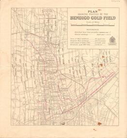
Map - BENDIGO GOLD FIELD - MAP OF PORTION OF THE BENDIGO GOLD FIELD
Map showing portion of the Bendigo Gold Field showing Alluvial working, shaft sites , streets and lines of reefs.Department of Mines, Victoria. Many mines, lines of reefs and gullies are on the map. Blue Royal Historical Society of Victoria Bendigo Branch stamp on the back.document, bendigo gold field, department of mines, lines of reefs, gullies, mines -
 Bendigo Historical Society Inc.
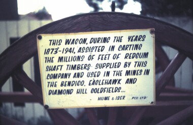
Slide - BENDIGO & EASTER FAIR, 1970
Wagon at Hume & Iser Pty Ltd. Signed attached to wagon reads This wagon, during the years 1873-1941, assisted in carting the millions of red gum shaft timbers supplied by this company and used in the mines in the Bendigo, Eaglehawk and Diamond Hill Goldfields. . . Hume & Iser Pty Ltd. See wagon in SL1608.67slide, bendigo, hume & iser pty ltd, hume & iser, sign on wagon -
 Bendigo Historical Society Inc.
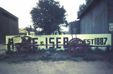
Slide - HUME AND ISER TIMBER WAGON (1873 - 1941), 1970
Timber wagon at Hume and Iser Pty Ltd est 1887. Timber wagon, large wheels, pictured in front of Hume and Iser sign. Sign attached to wagon reads, 'This wagon, during the years 1873-1941, assisted in carting the millions of red gum shaft timbers supplied by this company and used in the mines in the Bendigo, Eaglehawk and Diamond Hill Goldfields. Hume & Iser Pty Ltd.' Could have been used in Easter Parade?slide, bendigo, hume & iser pty ltd, hume & iser pty ltd, red gum used in gold mines -
Bendigo Historical Society Inc.
Map - GREAT EXTENDED HUSTLER'S MINE - LONGITUDINAL SECTION OF THE GREAT EXTENDED HUSTLER'S MINE
Longitudinal Section of the Great Extended Hustler's Mine on the Hustler's Line of Reefs. Bulletin No 33, Plate No XIII. Map shows the Hustler's Tribute, 2 Old Shafts, Great Extended Hustler's Shaft, Latham & Watson's Shaft and Ironbark Gully. Datum Line 750 feet above Sea Level. Poppet Legs on the surface and Sill of Shaft 788.99 feet above Sea Level. Levels and their depths are shown and some geographical features. Some amounts of gold mined mentioned. Geological Survey of Victoria emblem and signed by H A Whitelaw, Underground Survey Office Bendigo, September 1913. Note - Plates 4, 8, 13,20, 26 & 31 form a Longitudinal Section from Fortuna Hustlers to Hustler's Consols Mine. This item has not been scanned or photographed.mining, parish map, great extended hustler's mine, longitudinal section of the great extended hustler's mine, geological survey of victoria, underground survey office bendigo, h a whitelaw, hustler's tribute, old shaft, great extended hustler's shaft, latham & watson's shaft, ironbark gully -
Bendigo Historical Society Inc.
Map - GREAT EXTENDED HUSTLER'S MINE - TRANSVERSE SECTION OF THE GREAT EXTENDED HUSTLER'S MINE
... Section of the Great Extended Hustler's Mine Old Shaft Mr Walker ...Transverse Section of the Great Extended Hustler's Mine on the Hustler's Line of Reef. Bulletin No 33, Plate No XII. Shows Poppet legs at the surface and Sill of Shaft at 788.99 feet above Sea Level, Cross Cuts and their depths, stone and geographical features encountered and their references and a number of enlarged drawing of sections of the cross cuts, Geological Survey of Victoria emblem and signed by H A Whitelaw, Underground Survey Office Bendigo, September 1913. The depths of crosscuts to No 21 were taken from plans of surveys by Mr Walker and Mr Craven, noted under Reference. Another note: This Saddle Reef is sketched from Mr Walker's plan. Dividends amounting to 360,000 pounds were obtained from it. This item has not been scanned or photographed.mining, parish map, great extended hustler's mine, transverse section of the great extended hustler's mine, old shaft, mr walker, mr craven, geological survey of victoria, underground survey office bendigo, h a whitelaw -
 Bendigo Historical Society Inc.
Map - GREAT EXTENDED HUSTLER'S MINE - PLAN OF THE GREAT EXTENDED HUSTLER'S MINE
... MINING Parish Map Great Extended Hustler's Mine No 2 Shaft Latham ...Plan of the Great Extended Hustler's Mine. Bulletin No 33, Plate No XI. Shows No 2 Shaft, Latham & Watson's Shaft, levels and their depths and some geographical features. Geographical Survey of Victoria emblem and signed by H A Whitelaw, Underground Survey Office, Bendigo, September 1913. Has reference to photos.mining, parish map, great extended hustler's mine, no 2 shaft, latham & watson's shaft, geological survey of victoria, underground survey office bendigo, h a whitelaw -
 Bendigo Historical Society Inc.
Map - GREAT EXTENDED HUSTLER'S MINE - PLAN OF THE GREAT EXTENDED HUSTLER'S MINE
Plan of the Great Extended Hustler's Mine on the Hustler's Line of Reefs, Bendigo. Bulletin No 33, Plate No X. Lease No 7382. Plan has map of streets. Mine was located in the block bounded by Langston and Anderson Streets and was between the Hustler's Anticline at Surface and the Lightning Hill Anticline at Surface. Latham & Watson's Shaft is also mentioned. Levels are numbered and a table shows the Levels and their Depths. Geological Survey of Victoria. Signed by H A Whitelaw, Underground Suyrvey Office, Bendigo, September 1913. This item has not been scanned or photographed.mining, parish map, great extended hustler's mine, hustler's line of reefs, mining lease no 7382, geological survey of victoria, underground survey office bendigo, h a whitelaw, latham & watson's shaft -
Bendigo Historical Society Inc.
Map - FORTUNA HUSTLER'S MINE - TRANSVERSE SECTION OF THE FORTUNA HUSTLER'S MINE
Transverse Section of the Fortuna Hustler's Mine on the Hustler's Line of Reef, Bendigo. Bulletin No 33, Plate No III. Drawing shows poppet legs on the surface and Sill of Shaft 745.38 feet above Sea Level. Shows levels and their depths, geographical features and stone encountered. Reference table to stone and geographical features. Geographical Survey of Victoria emblem. Signed by H A Whitelaw, Underground Survey Office, Bendigo. This item has not been scanned or photographed.mining, parish map, fortuna hustler's mine, hustler's line of reef, geological survey of victoria, underground survey office bendigo, h a whitelaw -
Bendigo Historical Society Inc.
Map - HUSTLER'S CONSOLS MINE - TRANSVERSE SECTION OF THE HUSTLER'S CONSOLS MINE
Transverse Section of the Hustler's Consols Mine Bulletin No 33, Plate No XXXIII. Map shows poppet legs at the surface and Sill of Shaft 779.42 feet above Sea Level. Shows the different levels and their depths and the different stone and geographical features encountered. Has larger drawing of Section A - B. Geographical Survey of Victoria. Signed by H A Whitelaw, Underground Survey Office Bendigo, September 1913. This Item has not been scanned or Photographed.mining, parish map, hustler's consols mine, transverse section of the hustler's consols mine, geological survey of victoria, underground survey office bendigo, h a whitelaw -
Bendigo Historical Society Inc.
Map - HUSTLER'S REEF MINE - TRANSVERSE SECTION OF THE HUSTLER'S REEF MINE
Transverse Section of the Hustler's Reef Mine on the Hustler's Line of Reefs. Bulletin No 33, Plate No XVIII. Shows cross-cuts and their depth, different types of stone and geological features encountered. Drawing of poppet legs at the surface and Sill of Shaft 756.39 ft above Sea Level. Reference Table shows key to the different stone and geographical features encountered. Geographical Survey of Victoria. Signed by H A Whitelaw, Underground Survey Office, Bendigo, September 1913. Thompson's Reef is also mentioned on the map. This item has not been scanned or photographed.mining, parish map, hustler's reef mine, transverse section of the hustler's reef mine, geological survey of victoria, h a whitelaw, underground survey office bendigo, thompson's reef. -
 Bendigo Historical Society Inc.
Map - HUSTLER'S REEF MINE - EAST & WEST CROSS-CUTS, NORTH & SOUTH OF SHAFT
... Reef Mine Bulletin No 33, Plate No XIX. Map shows main shaft..., North & South of Shaft, Hustler's Reef Mine Bulletin No 33 ...East & West Cross-cuts, North & South of Shaft, Hustler's Reef Mine Bulletin No 33, Plate No XIX. Map shows main shaft and smaller drawing of section with different stone encountered. Also gives location in relation to the shaft, e. g. 225'E & 150'S of Shaft. Reference diagram to show the different stone and features encountered. Geological Survey of Victoria emblem. Signed by H A Whitelaw, Underground Survey Office Bendigo, September 1913. This item has not been scanned or photographed.mining, parish map, hustler's reef mine, east & west cross-cuts north & south of shaft, geological survey of victoria, h a whitelaw, underground survey office bendigo -
Bendigo Historical Society Inc.
Map - HUSTLER'S REEF & HUSTLER'S REEF NO 1 MINES - LONGITUDINAL SECTION OF THE HUSTLER'S REEF & HUSTLER'S
Longitudinal Section of the Hustler's Reef & Hustler's Reef No 1 Mines on the Hustler's Line of Reef. Bulletin No 33, Plate No XX. Note - Plates 4, 8, 13, 20, 26 & 31 form a Longitudinal Section from Fortuna Hustler's to Hustler's Consols Mine. Geological Survey of Victoria emblem. Signed by H A Whitelaw, Underground Survey Office Bendigo, September 1913. Shows the two shafts with their levels and depths. Also shows geographical features and yields of gold and amalgam per ton. This item has not been scanned or photographed.mining, parish map, hustler's reef & hustler's reef no 1 mines, longitudinal section of the hustler's reef & hustler's reef no 1 mines, geographical survey of victoria, underground survey office bendigo, h a whitelaw -
Bendigo Historical Society Inc.
Map - HUSTLER'S REEF & HUSTLER'S REEF NO 1 MINES - PLAN OF THE HUSTLER'S REEF & HUSTLER'S REEF NO 1 MINES
Plan of the Hustler's Reef & Hustler's Reef No 1 Mines on the Hustler's Line of Reefs, Bendigo Bulletin No 33, Plate No XIV. No 8 connecting No 10 (Hustler's Reef), No 11 connecting No 13 (Hustler's Reef), No 13 (Hustler's Reef No 1) connecting No 15 (Hustler's Reef) and No 10 Hustler's Reef No 1 rise to Comet Mine. Map shows different levels in relation to the two shafts, the lines of the Hustler's Line of Reefs and the Lightning Hill Line of Reefs, the approximate Boundary of Lease and the Comet Co., the adjoining lease. Table on the left shows the levels and their depths of the two mines. Signed by H A Whitelaw, Underground Survey Office, Bendigo, September 1913. Geological Survey of Victoria emblem. This item has not been scanned or photographed.mining, parish map, hustler's reef & hustler's reef no 1 mines, plan of the hustler's reef & hustler's reef no 1 mines, hustler's line of reefs lightning hill line of reefs, comet co., h a whitelaw, underground survey office bendigo, geological survey of victoria -
Bendigo Historical Society Inc.
Map - HUSTLER'S REEF & HUSTLER'S REEF NO 1 MINES - PLAN OF THE HUSTLER'S REEF & HUSTLER'S REEF NO 1 MINES
Plan of the Hustler's Reef & Hustler's Reef No 1 Mines on the Hustler's Line of Reefs, Bendigo Bulletin No 33, Plate No XVI. Plan shows the two shafts and the levels in relation to it. No 9 Level 896 feet 9 inches connecting No 10 Level at 867 feet 2 inches. Plan shows depth of levels and geographical features. Signed by H A Whitelaw, Underground Survey Office, Bendigo. Geographical Survey of Victoria emblem.mining, parish map, hustler's reef & hustler's reef no 1 mines, hustler's line of reefs, plan of the hustler's reef & hustler's reef no 1 mines, h a whitelaw, underground survey office bendigo, geographical survey of victoria, mining -
Bendigo Historical Society Inc.
Map - HUSTLER'S REEF & HUSTLER'S REEF NO 1 MINES - PLAN OF THE HUSTLER'S REEF & HUSTLER'S REEF NO 1 MINES
Plan of the Hustler's Reef & Hustler's Reef No 1 Mines on the Hustler's Line of Reefs Bulletin No 33, Plate No XV. Plan shows the two mines with depth of levels, geological features and levels in relation to the shaft. Geological Survey of Victoria emblem and signed by H A Whitelaw, Underground Survey Office Bendigo, September 1913. Note - The Lease Boundaries shown on this plan are only in their approximate relative positions to Nos 13, Intermediate and 14 Levels of the Hustler's Reef No 1 workings, and Nos 15, 16 and 17 Levels of the Hustler's Reef workings.mining, parish map, hustler's reef & hustler's reef no 1 mines, plan of the hustler's reef & hustler's reef no 1 mines, geological survey of victoria, underground survey office bendigo, h a whitelaw, hustler's line of reefs