Showing 1005 items
matching navigational
-
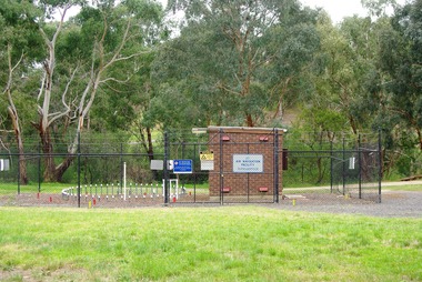 Greensborough Historical Society
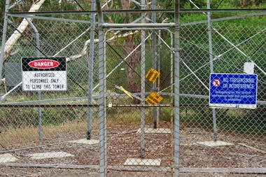
Photograph - Digital Image, Marilyn Smith, Air Navigation Facility, Montmorency, 2018. Long view, 04/12/2018
Air Navigation Facility, Palara Court Montmorency, is made up of a tower and brick building surrounded by wire fences. It is sited in parkland at the end of Palara Court close to the Plenty River Trail. Warning signs are placed on the fences, including: "This facility is provided for the control and guidance of aircraft".Digital copy of colour photographsair navigation facility, air control, palara court montmorency -
 Greensborough Historical Society
Photograph - Digital Image, Marilyn Smith, Air Navigation Facility, Montmorency, 2018. Close up, 04/12/2018
Air Navigation Facility, Palara Court Montmorency, is made up of a tower and brick building surrounded by wire fences. It is sited in parkland at the end of Palara Court close to the Plenty River Trail. Warning signs are placed on the fences, including: "This facility is provided for the control and guidance of aircraft".Digital copy of colour photographair navigation facility, air control, palara court montmorency -
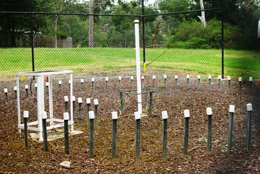
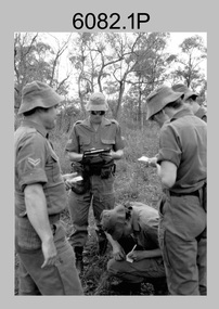 Bendigo Military Museum
Photograph - Army Survey Regiment - Regimental Training Navigation Exercise, 1985
This is a set of 16 photographs of Army Survey Regiment personnel undertaking a non-tactical navigation exercise, part of the field phase of regimental training in the Wellsford Forest, Bendigo 1985. This was one of the six regimental training objectives outlined in the administrative instruction – Exercise “City Soldier” accompanying these photos. The other objectives were SLR rifle and M30 grenade handling revision, and first aid at Fortuna; RATEL at Wellsford Forest and rifle shooting at Wellsford Rifle Range. Personnel from Air Survey, Cartographic, Lithographic and Headquarters Squadrons were reallocated to four training platoons for one week from 7th to 11th October 1985.This is a set of 16 photographs of Army Survey Regiment personnel undertaking a navigation exercise in the Wellford Forest, Bendigo 1985. Black & white photos .1P to .10P are printed on photographic paper and scanned at 300 dpi. Photos .11P to .16P are on 35mm negative film and scanned at 96 dpi. They are part of the Army Survey Regiment’s Collection. .1) - Photo, black & white, 1985, L to R: CPL Mick Minchin, SGT Alan Staley, CPL Megan (McBurney) Reynolds SPR Wendy (Leitinger) McCarthy. .2) - Photo, black & white, 1985, L to R: unidentified, SPR Wendy (Leitinger) McCarthy, CPL Megan (McBurney) Reynolds, unidentified, SGT Alan Staley, SPR Dave Lawler. .3) - Photo, black & white, 1985, L to R: CPL Greg Honan, CPL Grant McGuinness, SPR Leah (Hoffman) Peppler, CPL Ken Peters, SSGT Ian ‘Rock’ Thistleton, SSGT Kevin ‘Spook’ Kennedy. .4) - Photo, black & white, 1985, unidentified personnel. .5) - Photo, black & white, 1985, L to R: CPL Peter ‘Spoon’ Lefel, unidentified, CPL Mick ‘Buddha’ Ellis. .6) - Photo, black & white, 1985, L to R: SSGT Harald Mai, unidentified. .7) - Photo, black & white, 1985, unidentified personnel. .8) - Photo, black & white, 1985, unidentified personnel. .9) - Photo, black & white, 1985, WO1 Dick Manley. .10) - Photo, black & white, 1985, L to R: LT Brenton MacDonald, LT Kathie Ryan, WO1 Brian Mead. .11) - Photo, black & white, 1985, L to R: LT Carol Dunstan, unidentified, CPL John Reid. .12) - Photo, black & white, 1985, L to R: WO1 Dick Manley, unidentified, LT Carol Dunstan. .13) - Photo, black & white, 1985, L to R: unidentified (x2), WO1 Dick Manley. .14) - Photo, black & white, 1985, LT Brenton McDonald. .15) - Photo, black & white, 1985, L to R: CPL Megan (McBurney) Reynolds, SPR Wendy (Leitinger) McCarthy, CPL Mick Minchin. .16) - Photo, black & white, 1985, L to R: SPR Wendy (Leitinger) McCarthy, CPL Mick Minchin..1P to .16P – No personnel are identified.royal australian survey corps, rasvy, army survey regiment, army svy regt, fortuna, asr -
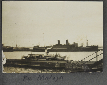 Mission to Seafarers Victoria
Photograph - Photograph, Sepia, P. O. Maloja, 1928
Named after another ship operating from 1911, RMS Maloja was a passenger liner of the Peninsular and Oriental Steam Navigation Company, operating between 1923 and 1954. In 1924: London/Colombo/Melbourne/Sydney service. During WWII the ship was requisitioned by the Admiralty for service as an Armed Merchant Cruiser.One of two photographs in the collection of a vessel named Maloja, which operated between London and Sydney via Ceylon (Sri Lanka as it later became).small landscape sepia photograph adhered to an album page. Depicts 2 vessels an ocean going 2 stack ship in the distance and a smaller vessel (ferry or coaster) moored against a pier.Hand-written on album page along lower edge in black ink: " PO Maloja"steam ships, world war 2, fan album, ships, piers, port melbourne -
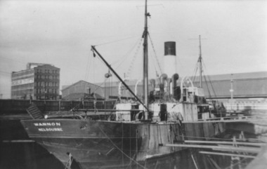 Port Fairy Historical Society Museum and Archives
Photograph, S.S.Wannon 1940 Melbourne
S.S.Wannon in Duke and Orr Dry Dock Melbourne 1940. Ship was purchased in 1935 by the Belfast and Koroit Steam Navigation Company as a replacement for the T.S.S.Coramba she purchased in New Zealand and renamed Wannon when her name was Gale. Photograph was taken after it was sold to W.Holyman and Sons in March 1939.Photographship, boat, sea, river, gale, wannon, port fairy, belfast and koroit steam navigation company, bksn co -
 Queenscliffe Maritime Museum
Instrument - Telescope
Spencer and Browning was established by William Spencer and Samuel Browning in 1778, before they entered into partnership with Ebenezer Rust in 1784. After the death of Ebenezer Rust's son, the successor business was known as Spencer, Browning & Co. The firm of Spencer, Browning & Rust made a variety of navigational instruments, including octants and sextants.This telescope was manufactured by a London firm established in 1778. The telescope is believed to be from around 1863.Two piece brass day or night telescopeSpencer, Browning and Co. London Day or Night telescope, navigational instruments -
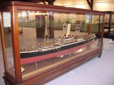 Seaworks Maritime Museum
Shipbuilders Model, SS Omrah
The original ship was built in Glasgow in 1899 by Fairfield Shipbuilding and Engineering Co for the Orient Line. It was the largest Orient Line passenger ship completed in the nineteenth century and was the third vessel of the Line to bear the famous “O” prefix, which was traditional through to the last ship, the mighty 'Oriana'. Her dimensions were 8,130 gross tons, length 490.6ft x beam 56.6ft (149.50 x 17.22m). She had one funnel, two masts, twin screw and a speed of 18½ knots. Her maiden voyage from London, via Suez, to Melbourne and Sydney commenced on 3rd February 1899. She was the largest British flag ship sailing to Australia at the time and continued to regularly sail between London, Melbourne and Sydney throughout her life. She last sailed as a passenger ship between Melbourne and Sydney on the 3rd November 1916. During World War I, she was converted to a troopship and was used to transport soldiers and assist with military operations. She was torpedoed and sunk by German submarine UB-52, 40 nautical miles (74km) off the coast of Sardinia in the 12 May 1918. She was on her return journey from Alexandria to Marseilles with six other transports, carrying troops of the 52nd and 74th divisions when she was lost, resulting in one casualty. Her maiden voyage brought her to Melbourne in 1899. The ship carried the first Australian troops from Brisbane to WWI in September 1914.A large ship builder's model of the 'SS Omrah' an Orient Line one funnel passenger steamer of 1899. The model is displayed in a large glass and polished timber case on legs.2 Plaques at foot of model: "MODEL/ OF TWIN SCREW STEAMER/ "OMRAH"/ BUILT FOR/ ORIENT STEAM NAVIGATION CO LTD/ BY/ THE FAIRFIELD SHIPBUILDING & engineering CO LTD/ DIMENSIONS/ 507-0X56-9X37-6MLD/ GROSS TONNAGE 8291 TONS SPEED 18 1/2 KNOTS on boat: "OMRAH" -
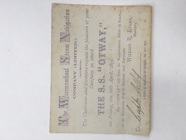 Warrnambool and District Historical Society Inc.
Ticket, The Warrnambool Steam Navigation Co Ltd, 1873
This card relates to an excursion aboard “The SS Otway leaving the Warrnambool Jetty at 8 am April 18th 1873 to go to Belfast and Portland courtesy of the Warrnambool Steam Navigation Company Limited which was originally called the Warrnambool Steam Packet Company. The Otway was the second steamer purchased by the company. It had a number of ships which traded along the coast including, the Nelson, Julia Percy, Otway and The Edina. The Edina was originally owned by Stephen Henty who was operating it from Portland but he sold it to the new company for £8500. Henty then withdrew from the Belfast and Warrnambool trade for a time but it proved to be a competitive business. The name was changed again in 1878 to The Western Steam Navigation Company and the SS Otway was put up for sale. This card relates to one of the first trips, if not the first trip, taken by the SS Otway Shipping was a major part of the history of Warrnambool and this ticket is a link to one of the earliest passenger and freight services which operated along the coast.Small cream card with light purple text with company name at the top. Capital letters done in scroll lettering. There are feint markings in the centre of the back which appear to have been rubbed off.Signed by Captn Selby. William R Evans manager. 18th April 1873.warrnambool steam navigation company, edina, stephen henty, s s otway -
Glenelg Shire Council Cultural Collection
Functional object - Life Buoy, n.d
Purchased by Glenelg Shire from Kurtze's Museum. The Casino commenced West Coast Trade in 1882 after being purchased by the Belfast and Koroit Steam Navigation Co. The Casino came to an end in 10.7.1932 when it rolled over and sank at Apollo Bay. Casino built at Dundee Scotland 425 reg. tons.Life buoy, circular ring, canvas covered cork, rope loop fixed to 4 points on the outside edge. Painted white "SS CASINO" and "PORT FAIRY" lettered in black. 2 images of flags painted opposite sides of the 'front' of buoy. Ex SS CASINO wrecked 10.7.1932.Front: 'SS Casino' 'Port Fairy' Back: - -
 Greensborough Historical Society
Photograph - Digital Image, Marilyn Smith, Air Navigation Facility, Montmorency, 2018. Signs at tower, 04/12/2018
Air Navigation Facility, Palara Court Montmorency, is made up of a tower and brick building surrounded by wire fences. It is sited in parkland at the end of Palara Court close to the Plenty River Trail. Warning signs are placed on the fences, including: "This facility is provided for the control and guidance of aircraft". This photograph shows signs at tower.Digital copy of colour photographair navigation facility, air control, palara court montmorency -
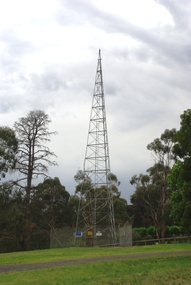 Greensborough Historical Society
Photograph - Digital Image, Marilyn Smith, Air Navigation Facility, Montmorency, 2018. Tower, 04/12/2018
Air Navigation Facility, Palara Court Montmorency, is made up of a tower and brick building surrounded by wire fences. It is sited in parkland at the end of Palara Court close to the Plenty River Trail. Warning signs are placed on the fences, including: "This facility is provided for the control and guidance of aircraft". This photograph shows the tower on the site.Digital copy of colour photographsair navigation facility, air control, palara court montmorency -
Moorabbin Air Museum
Archive (Item) - Box WP9 Prowse Collection See details under Description
Description: Manual of Air Navigation Vol 1 1941 Nomad Flight Manual, GAF Nomad N22S Searchmaster ‘B’ Variant - Operations Manual (3 copies) Nomad N22S Searchmaster ‘L’ Variant - Operations Manual Aircraft Book - French GAF Correspondence Regarding Development of Level of Importance: State. -
 Ballarat Clarendon College
Book, C L Brightwell, Heroes of the laboratory and the workshop, Preface dated 1859
Prize awarded to James Cleeland Shaw (BD 15/10/1862) for excellence in conduct and general proficiency. James entered Ballarat College 1870. Son of Mr. W.H.Shaw the Managing Director of the celebrated Phoenix Foundry which played such an important part in the early industrial history of Ballarat and who lived all his Ballarat life in a house in Armstrong Street South not far from Dana Street. Born in Ballarat on 15th October 1862 and attended Ballarat College 1870-1877. Was articled to Hardy and Madden of Ballarat Solicitors. Practised as a Solicitor in Ballarat for some years. Went to Western Australia in 1897 and acted for a time as Deputy Master of Western Australia Supreme Court. Was for some time partner with Drake Brockman now a judge but latterly practised as Shaw and Shaw in partnership with his brother Frank as Solicitors at 81 St. Georges Terrace, Perth, Western Australia. Example of prize ordered from London where they were specially bound and embossed with the College crest. Awarded by F J Thomas B A, principal under unusual circumstances 1874 - 1876.Preface dated 1859. A clean crisp book of 222 clean unmarked pages . 22 chapters, each dealing with a separate subject including; Berthollet - chemist; James Brindley - originator of canal navigation; Graham & Breguet - watch & clock makers; & Vaucanson - automata. Firmly bound in light brown calf with six compartments between raised bands and gilt title & decorations on the spine ; gilt school crest on the front; marbled end pages and edges.Book plate inside front cover: Ballarat College crest / PRIZE / FOR / Good Conduct and General Proficiency / Awarded to / Master J Shaw / Fifith Class / Christmas 1975 / F J Thomas B A Principalf-j-thomas, ballarat-college, james-shaw, 1875, book-prize -
 Parks Victoria - Wilsons Promontory Lightstation
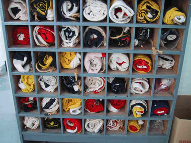
Flags, Navigational
The forty-two navigational flags appear to be a complete set. Their purpose-built, grey painted wooden locker is divided into forty-two pigeonholes, each holding one of the rolled up flags. It is simply built and stands on short legs and was originally open-fronted, but has since been covered with a protective clear Perspex panel. The set of alphabetic and numeric visual signalling flags (including substitute and answering pennants) are made of wool in various colour combination designs, with canvas sewn to one end that is threaded with hemp rope. Some of the flags have metal clips attached to the rope. The flags were used for communicating messages to passing ships. Knowledge of visual signalling was mandatory for all lightkeepers and all stations maintained a set of flags. Although used for centuries, visual flag signalling formally developed in the nineteenth century and was published internationally as a system in 1857. By the early twentieth century it had developed into an effective means of conveying all kinds of short range visual messages. Most flags are in good condition and their first level significance is enhanced by their completeness and integrity as a set still housed in their original locker, and by the signal charts that remain in the museum collection which offer further insights into visual signalling.1 - 42. Navigational flag set of 42 individual flags. Coloured linen with canvas sewn to one end which has hemp rope threaded through it. Some flags have metal clips attached to the ends of the hemp rope. 43. Wooden cupboard divided into sections with wooden divides. Used to house the 42 flags. • 1. navy & white. 2. navy & yellow. 3. navy & white. 4. white. 5. red & yellow. 6. yellow & navy. 7. yellow & navy. 8.red. 9.red & white. 10. white & navy. 11. red & navy & white. 12.yellow & navy & & red. 13.navy & white. 14. navy & white. 14. navy & white. 15.navy & white. 16. navy & yellow. 17. yellow & white. 18. white & red. 19. white & red. 20. yellow & red. 21. white & navy. 22. yellow & navy. 23. navy & white. 24. white & navy. 25.red & white. 26. navy & white. 27.red & white. 28.red & white. 29. red & navy. 30. white & navy. 31. yellow. 32.red 7 navy. 33. red. 34 navy,white,red & yellow.35. red & blue. 36. white & red. 37. navy & yellow. 38.red, yellow & white. 39. white. 40. white & red. 41. yellow & red. 42.navy. 43.custom built wooden open cupboard divided into sections to house flags.Yes -
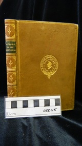
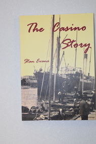 Warrnambool and District Historical Society Inc.
Book - book & bookmark, The Casino Story, 1882
History of the ship, 'Casino'.1 This is a book of 145 pages.The cover has a yellow background with an image of a ship and dark red printing. The back cover and spine have red and black printing. The pages contain black and white photographs and sketches and printed material. .2 This is a bookmark with two colour images and printed material on one side and one image and printed material on the other side.non-fictionHistory of the ship, 'Casino'the ship 'casino', warrnambool shipping history -
 Bendigo Military Museum
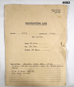
Document - NAVIGATION DOCUMENT, Navigation Log, 22.11.1942
Navigation Log for flight by A.T.S in Aeroplane W - 2275 operating under order No 18/40. Details filled in on form RAAF A.84. Form filled in by F/L Smith, Sgt Jones, P/O Jones. Part of the Frederick Gardner DFC RAAF No 410533 collection. Refer Cat No 3536P for his service details.Four page Proforma printed in black ink, handwritten details in pencil on pages 1,2,3.The hand written information pages 1,2,3, details a flight from Pt Nepean to Woodside, weather, wind speed and observation points noted.training flight, raaf, w - 2275 -
 Phillip Island and District Historical Society Inc.
Photograph, The "Speke", 1906 (original photograph)
One of a collection of 6 photographs donated by Anne Grayden. The Speke was the third largest 3 masted ships built in 1891. It was wrecked in 1906 near Kitty Miller Bay due to a navigational error. One man drowned but the rest of the crew reached safety. Remains of the hull are a tourist attraction now over 100 years later.Black & White photograph of the wreck of the Speke. The shop is listing but still in one piece. It is in the water seemingly stuck on rocks.the speke, wreck of the speke, phillip island ship wrecks, anne grayden -
Lakes Entrance Regional Historical Society (operating as Lakes Entrance History Centre & Museum)
Postcard, Gippsland Steam Navigation Co, 1905
Advertisement on reverse 'Gippsland Steam Navigation Co Proprietary Limited Bairnsdale Melbourne Line SS Wyrallah 302 tons Twin Screw leaves Bairnsdale every Saturday Morning leaves Melbourne every Wednesday Cargo Received at Bairnsdale Wharf Daily Office opposite lower wharf Bairnsdale J B Carpenter Branch Manager'Black and white postcard showing SS Wyrallah steaming quietly in the Mitchell River with man standing at rail of forward deck, passengers on lower and upper after decks Gippsland VictoriaSS Wyrallah (Trading between Melbourne and the Gippsland Lakes)ocean, recreation -
 Queenscliffe Maritime Museum
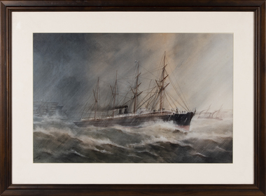
Print - Reproduction print, framed, AV Gregory, Ormus 1887
In 1883 The Orient Steam Navigation Co. Ltd., of London signed a contract with the Government of New South Wales, Australia to carry emigrants from the United Kingdom. The Company would be paid £15 per head for up to four hundred persons and £14 and 10 Shillings for numbers between four and six hundred persons per voyage.A reproduction print of a painting by AV Gregory of the vessel Ormus, 1887. The print is mounted under glass and framed in a dark brown timber frame.rms ormuz, reproduction print -
 Orbost & District Historical Society
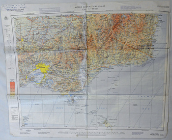
map, 1985
An aeronautical chart is a map designed to assist in navigation of aircraft. Using these charts and other tools, pilots are able to determine their position, safe altitude, best route to a destination, navigation aids along the way, alternative landing areas in case of an in-flight emergency, and other useful information such as radio frequencies and airspace boundaries. World aeronautical charts have a scale of 1:1,000,000 and cover relatively large areas. Orbost Aero Club began in 1969 with Basil Dowie as Chair, David Nixon as Secretary/Treasurer. The group went into recess from 1977-1991 closing in 1997. The mid 1960s were boom years in flying training in Australia and the number of Aero Clubs grew rapidly. The Club played a significant role in the establishment of the small airport at Marlo and in the ongoing operation and development of the airport over the years particularly for patient transfer by aerial ambulance. The Orbost Aero Club Club played a significant role in the establishment of the small airport at Marlo and in the ongoing operation and development of the airport over the years.A laminated map of eastern Victoria. A World Aeronautical Chart. It shows elevations, longitude etc and is designed for pre-flight planning as well as pilotage. Top left hand corner - D.F.N.Nixon VH-FWD 12 Kristine Ct Cheletenham 27/7/87orbost-aero-club aeronautical-map -
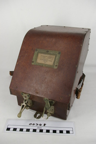
 Bendigo Military Museum
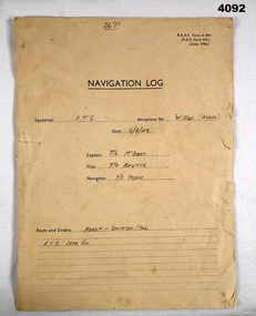
Document - NAVIGATION DOCUMENT, Navigation Log, 6.2.1942
Navigation Log for Training Flights by A.T.S in Aeroplane W1234 (Anson), details filled in on RAAF form A.84. Filled by F/L McBoast, P/O Prune, F/O Knutts. (These are fictitious names to obviously give an example) Part of the Frederick Gardner Davey DFC No 410533 RAAF Collection. refer Cat No 3536P for his service details.Four page proforma printed in black ink, handwritten details on pages 1,2,3,, page four no handwritten details.Hand written in format on pages 1 - 3 in pencil detailing flight flight from Koroit to Smithton (Tasmania), weather, wind speed and observation points.navigation log, training flights, raaf -
 Forests Commission Retired Personnel Association (FCRPA)
Prismatic Compass with leather case and strap, Ex Army 1940s
A prismatic compass is a common navigation and surveying instrument which was used extensively by the Forests Commission The compass most commonly used to run a traverse line. The compass calculates bearings of lines with respect to magnetic needle. A magnetic deviation correction was needed to convert the reading to a true bearing The compass could also determine angles between the traverse and waypoints (such as hilltop features). Commonly used for navigation. Largely replaced by modern GPS technology.Ex Army WW2 prismatic compass with leather case and strap. Rugged design and made of metal the internal compass plate floats on oil to help it stabilise The user lines up the direction of travel with the hair sightline in the fliptop cover and readings are taken through the viewfinder prism (hence the name).forest measurement, surveying, forests commission victoria (fcv) -
 Ringwood and District Historical Society
Map - Public Land Sale by Thomas Ham, 2000 Acres for Sale - Crown Sections 20, 23, 24 - Ringwood, Victoria - 1855
Two 1850s surveyor's maps on cardboard backing showing area from Melbourne extending East beyond Bulleen and Nunawading. Detailed description of lots for sale and navigational directions to the property from Richmond by Thomas Ham, Victorian public servant, map maker, publisher, lithographer and original Ringwood land owner. Inset map enlarging area between Yarra River and Dandenong Creek, with southern boundary of allotments later forming part of Oban Road, North Ringwood.TRANSCRIPT: "This really valuable Property is now offered to the public for sale, in lots to suit purchasers at the Iow rate of £1 per Acre for 80 acres and upwards, and £1.10s per Acre for any smaller portion. Terms of payment Half Cash, Balance in 6 and 12 months, bearing 8 per cent interest. The Estate is well wooded with Gum, Cherry Tree and Stringy Bark, with Wattle in the valleys of the several creeks. Every lot is Staked and Trenched at the corners marked on the Plan thus - The Surveyor has carefully sub-divided the Property, in order to give every Farm a Creek for Water, Valley for Cultivation, and Hills for House and Grass Paddock. The ROADS have been very carefully laid out so as to give a firm, well drained, and nearly level road to each Homestead. Intending purchasers can readily find the property by the following directions, viz: Start from Richmond Bridge, at Hawthorne, then take the left-hand road to KEW. When at the "Woodman Inn", take the Cotham Road to the right, bearing due east, keep this Road, passing Trainor's "White Horse" Inn, and before you leave the fences, you will see calico bills (see margin) nailed to the Trees on the bush track leading to the Upper Yarra country, follow the Bills till you come to the SOUTH boundary line of the Property, which bears East and West (see Plan) where you will see Bills nailed up "THIS PROPERTY FOR SALE, etc." The Bills from Town lead direct to where Mr. Jull is erecting his Store, and arrangements have been made with him to show the lots to intending purchasers free of charge. At the respective corners of the lots the Bills are nailed up double, with numbers to denote the lot, and that the corner stake is adjacent. Any parties wishing to proceed to the property by way of BULLEEN will find Bills nailed on the Trees, commencing at the NEW INN, at "Wilson's Slip Rail." Keep this Track till you come to the Log Bridge, over the Deep Creek at Bloxhome's Paddock; go through the land now being cleared; keep the track over the hill till you come to an Iron House, you will then be on the property, which Iies to the North and East as per Plan. Follow the Bills till you come to Mr. Jull's Store, etc. etc. Further particulars can be had from the Agent for the Property. THOMAS HAM. " -
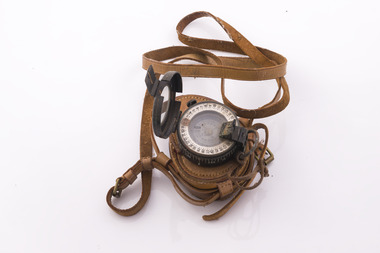
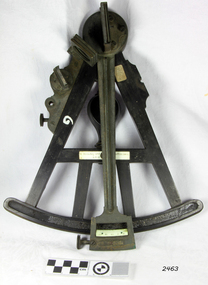
 Frankston RSL Sub Branch
Sextant, Bubble
Bubble Sextant model Mark 1XA type A.M. 6B/218 in protective storage box. Complete, with operation instructions. This is an aviation navigation instrument used by the RAF and RAAF during the World War 2 era. A sextant is used to measure the altitude of celestial bodies above a horizontal line of reference. A navigator can use the horizon as this line of reference, but when an aircraft is above the clouds or flying at night, the navigator can’t see the horizon. The bubble sextant solves this problem by providing an artificial horizon.The storage case has a label with the following: "A.M. 6B/218 MK IX A" and the number "10772/42 (V)" -
Glenelg Shire Council Cultural Collection
Functional object - Compass, Compass from ex-wreck of S.S. Barwon, 1860-1870
S.S. Barwon was built in 1868, 419 tons gross. 376 tons nett, length 172.3 feet, beam 21.6 ft depth 14 feet. Bound from Adelaide to Sydney when total wrecked in Bridgewater Bay 3 April 1871. Owned by the Henty's. No loss of life. The Master Captain Shoobert and the second mate were found guilty of faulty navigation.Compass - ex-wreck of S.S. Barwon, lost of Cape Bridgewater 1871. Gimballed in timber box, no lid, compass arm and glass missing.Front: (no inscriptions) Back: (no inscriptions)ss barwon ship -
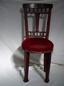 Port Fairy Historical Society Museum and Archives
Furniture, c. 1882
Saloon chair on the S.S.Casino. Removed for refurbishment to celebrate fifty year anniversary of the ship and the Belfast and Koroit Steam Navigation Company. The ship sank on the 9th July 1932 at Apollo Bay. This chair which had not been reupholstered chair registration 555 was presented to Capt. Thomas Boyd the first Captain of the Casino. The legs were added at some time after the sinking.Wooden chair with decorative carved back. Seat velvet upholstered. Wooden legs added after 1932local history, maritime technology, ship furniture, s.s.casino, belfast and koroit steam navigation company, b.k.s.n. -
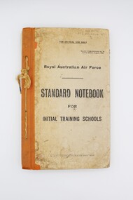 Shepparton RSL Sub Branch
Book, Royal Australian Air Force, Standard Notebook for Initial Training Schools: Air Navigation, August 1942
This notebook contains information on air navigation and electrical science. It was issued to Roy Eliason (449852), a Shepparton local who enlisted in 1944 and served as a Leading Aircraftman with the 2nd Operational Training Unit Mildura. Contents include: Appendix I: Law, Discipline, Administration and Organisation, Hygiene and Sanitation, Notes on Meteorology, Definitions, The principles of flight, Airframes, Engine; Appendix II: Mathematics problems for revision.This notebook has significant research potential, as it bears the service number of the owner: Roy Eliason. Roy Eliason's service history is well documented in the National Archives of Australia and this book provides an insight into a period of his service. Notebooks such as this were presumably issued to new recruits in the early stages of their service. Though this copy is in fair condition with several signs of wear, these signs may in fact increase the significance of the item, demonstrating the frequent use of this item in the hands of a new recruit to the Royal Australian Air Force. Series of pages bound via twine passed through four holes along left side. Front and back cover are card with orange vinyl/fabric strip and paper cover bearing title text. Orange pages throughout mark sections. Book printed throughout.Inscribed on front cover: "449852/AC2 ELIASON R/B/2". Inscribed on interior "449852/ELIASON. R./B/2". air navigation, training, royal australian air force, raaf, eliason, world war ii, wwii, second world war -
 Flagstaff Hill Maritime Museum and Village
Octant, Late 18th to mid-19th century
An Octant is a doubly reflecting navigation instrument used primarily by sailors to measure the angular distance between two visible objects and was a forerunner of the sextant. The name comes from the Latin octo, or “one-eighth of a circle,” for the Octant’s arc which spans 45°, or one-eighth of a circle. The primary use of an Octant is to measure the angle between an astronomical object and the horizon for the purposes of celestial navigation. The estimation of this angle is known as sighting or shooting the object, or taking a sight. The angle, and the time when it was measured, can be used to calculate a position line on a nautical chart (latitude), for example, sighting the Sun at noon or Polaris at night (in the Northern Hemisphere) gives an angle by which the latitude can then be estimated. Sighting the height of a landmark on land can also give a measure of distance. History: The principle of the Octant as an instrument to measure ones latitude was first implemented around 1742-present but was superseded by the improvement of the octant to a sextant, a very similar instrument, better made and able to measure bigger angles 120°, allowing the measurement of Luna distances to give longitude when used with an accurate chronometer. The sextant started to appear around 1730 and had been attributed to by John Hadley (1682–1744) and Thomas Godfrey (1704–1749), but reference to the sextant was also found later in the unpublished writings of Isaac Newton (1643–1727). Earlier links can be found to Bartholomew Gosnold (1571–1607) indicating that the use of a Sextant for nautical navigation predates Hadley's implementation. In 1922, the sextant was modified for aeronautical navigation by Portuguese navigator and naval officer Gago Coutinho. Henry Hemsley was a lesser-known instrument maker and optician working in London in the late 17th and early 18th century. However, it should be noted that there were two Henry Hemsley opticians and instrument makers around this period. (Henry Hemsley 1, 1786-89, who had premises at 85 Fleet St London and Henry Hemsley 2, 1828-56), whose workshop was at 135-138 Radcliff Highway London. Therefore, based on the inscribed workshop address Henry Hemsley 2 is responsible for making this example.The octant is representative of its type and although not fully complete it demonstrates how 18th and 19th-century mariners determined their latitude on a chart to navigate their way across the world's oceans in the 18th and 19th century. It also demonstrates the skill and workmanship of the early instrument makers that operated from London at this time and provided most of the navigational instrumentation use by commercial and military navies of the time.Octant, ebony wooden frame and handle. Scale is missing from recess in frame. "H. Hemsley 135-138 Ratliff Highway, London", no box"H. Hemsley 135-138 Ratcliff Highway, London"flagstaff hill, warrnambool, shipwrecked-coast, flagstaff-hill, flagstaff-hill-maritime-museum, maritime-museum, shipwreck-coast, flagstaff-hill-maritime-village, navigation, navigational instrument, instrument used for navigation, sextant, henry hemsley, instrument maker, london, octant -
 Bendigo Historical Society Inc.
Document - LYDIA CHANCELLOR COLLECTION; CROSSING THE EQUATOR CERTIFICATE
A certificate with green and black ink with the heading 'Domain of Neptunus Rex.' It is a Crossing of the Equator Certificate which occurred on the 2nd Nov. 1930 in Latitude 000 '00' and Longitude 165 W on S.S. Sonoma. Initiation of Mr. L.G. Pethard, ' having been found worthy to be remembered as one of our trusty shellbacks has been gathered to our fold and duly initiated into the 'Solemn Mysteries of the Ancient Order of the Deep.' 'Davy Jones His Majesty's Scribe.' 'Neptunus Rex Order of the Raging Main.' Matson Navigation Company.document, certificate, crossing the equator, lydia chancellor, collection, mr. l.g. pethard, person, equator -
 Bendigo Historical Society Inc.
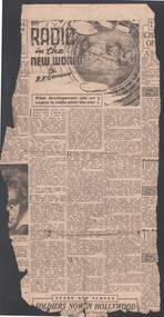
Newspaper - BILL ASHMAN COLLECTION: CORRESPONDENCE
Newspaper article titled 'Radio in the New World' by R. K. Gerrand from the Melbourne, The Herald. Piece has been torn from the paper and the only date is Saturday, Dec. Sub-heading is: What developments can we expect in radio after the war? Items covered are: X-rays, Outback radio telephones, travel telephones, Portable trans-ceivers, Automatic weather reporting stations, Frequency modulations, Television, Electronic microscope, radio location, Battle of Britain, Battle of Australia, navigation and Pasteurisation,sciences, instruments - general, scalebuoy, bill ashman collection - correspondence, the herald melbourne, r k gerrand, radio in the new world, f w clarke, electronic industries ltd, radio corporation, x-rays, outback radio telephones, travel telephones, portable trans-ceivers, automatic weather reporting statins, frequency modulations, television, electronic microscope, radio location, battle of britain, battle of australia, navigation, pasteurisation