Showing 2550 items
matching no 76
-
 Bacchus Marsh & District Historical Society
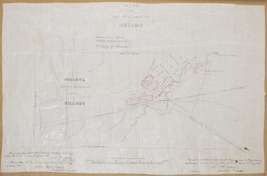
Map, Plan of the Village of Melton
A single page paper map showing a plan for the village of Melton, Parish of Djerriwarrh, County of Bourke. The map is pasted into a bound volume containing 76 maps or plans in total. High resolution digital image stored on BMDHS computer network. melton victoria maps -
 Bacchus Marsh & District Historical Society
Map, Maddingley Township, Parish of Parwan, circa 1890s
Maddingley is a locality or township within the broader township area of Bacchus Marsh. This map is not dated. However features in Maddingley which appeared in the 1880s and 1890s are present in the map, These include the Bacchus Marsh Railway Station and the Bacchus Marsh Showgrounds. The main residential and commercial area of Maddingley is shown on this map in an area bounded by Bacchus Street, Barry Street, Griffith Street and Maddingley Road. Other streets visible are Franklin Street, Inglis Street, Labilliere Street, McCrae Street, Moore Street and part of Station Street.A single page paper map showing land allotments, streets, rivers, creeks, park lands, the railway line and Bacchus Marsh railway station in the township of Maddingley. The map is pasted into a bound volume containing 76 maps or plans in total. bacchus marsh victoria maps, maddingley victoria maps, land use, maddingley victoria history -
 Ringwood and District Historical Society
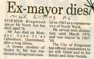
Newspaper, Scrapbook Clipping, Library Collection, Ringwood, Victoria
Newspaper Clipping from the ""Mail", 6 July 93, P5. "Ex-mayor dies"Former Ringwood mayor, Mr Norm Aus has died, aged 76. He died at Caboolture Queensland after a long illness. -
 Greensborough Historical Society
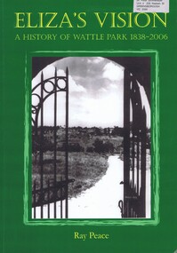
Book, Ray Pearce, Eliza's vision: a history of Wattle Park 1838-2006, 2006
An outline of the history of Wattle Park (Vic).207 p., illus., colour map.non-fictionAn outline of the history of Wattle Park (Vic).urban parks - melbourne, wattle park (vic.), parks - melbourne - history -
 Bendigo Military Museum
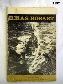
Literary work - BOOK, Naval Historical Society of Australia
The item belonged to Arthur George Holley No 13556 RAN, HMAS Hobart. Refer 2134 for service history also 2135.3, 2137, 2147. The history of "HMAS Hobart 1938-62". Cardboard covering with HMAS Hobart at the top, image of Hobart centre, Naval Historical Society of Australia at the bottom, 76 pages plus introductions, written by L.J Lind and M.A Payne. Copy No 456 of 1000. books, history, naval -
 Bendigo Historical Society Inc.
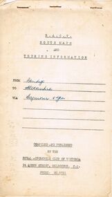
Document - J W SWATTON COLLECTION: RACV ROUTE MAPS
Four RACV Route Maps and Touring Information, Bendigo to Alexandra via Seymour and Yea, Bendigo to Mt Gambier and return, Bendigo to Horsham via Ararat and Bendigo to Anglesea, dated 1 March 76. Also an unsigned Safe Driving Pledge.j w swatton collection, royal automobile club of victoria -
 Bendigo Historical Society Inc.
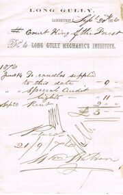
Document - ANCIENT ORDER OF FORESTERS NO. 3770 COLLECTION: ACCOUNT/RECEIPT
Account to Court King of the Forest from the Long Gully Mechanic's Institute dated June 14 for candles supplied 9/-, Special Audit Lights 11/- and Sep 20 1876 Rent £2. Total £3. Paid 21/9/76societies, correspondence, ancient order of foresters no. 3770 collection - account/receipt, court king of the forest, long gully mechanic's institute -
 Bacchus Marsh & District Historical Society
Map, Tracing of plan shewing portion through Bacchus Marsh District of proposed new Main Road between Gisborne and Blackwood
Road construction and planning was a primary function of the early local government authorities in rural and regional Victoria. This plan is indicative of the sort of documentation which generated considerable public interest and comment in rural communities. The date of this plan is not clear. Newspaper articles in the Bacchus Marsh Express around 1869 contain numerous references to the proposed new road between Gisborne and Blackwood which suggests this plan may date from the late 1860s or early 1870s.A single page paper map showing the proposed route of a main road to be constructed between Gisborne and Blackwood. The map is pasted into a bound volume containing 76 maps or plans in total. High resolution digital image stored on BMDHS computer network. roads, road plans, bacchus marsh victoria maps, gisborne to blackwood main road -
 University of Melbourne, Burnley Campus Archives
Slide - 35mm Colour slides, Miscellaneous Burnley, 1975-1979
7. "Ranunculus & Anemone" Apr 75. 5. "Citrus (Pruned) Dec" Jan 75. 4. "Student Veg Plots 1975" Feb 75. 3. "Noel Wilson Carnations 3rd Year 75" Apr 75. 2. "Dendrobium Orchid 75" May 75. Daisy Oct 75. 12. "Downy Mildew" Mar 76. "Indoor Plants Sanservia" Aug 76. School bus Jun 77. Orchid Revolving Protocorms" Nov 77. 8. "Cymbid Back Bulb" May 78. "Budding Citrus in Containers" Mar 79. "Bunkers RMGC" Nov 79.flowers, students, vegetables plots, citrus, indoor plants, school bus, orchids, orchard, diseases -
 Ringwood and District Historical Society
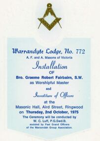
Programme - Investiture of Officers, Warrandyte Lodge No.772, A.F. and A. Masons of Victoria, Masonic Hall, Ringwood, Victoria
Folded cream coloured Installation Ceremony programme - Installation of Bro. Graeme Robert Fairbairn and Investiture of Officers at Masonic Hall, Aird Street, Ringwood on Thursday, 2nd October, 1975. Includes list of Officers 1975-76 and list of Past Masters of the Lodge. -
 Phillip Island and District Historical Society Inc.
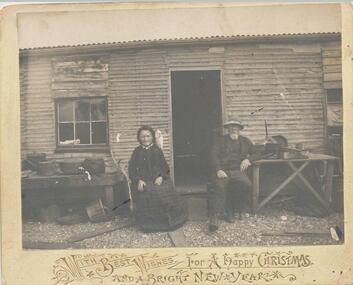
Photograph - Post Card, Grayden, Late 1800's
Donated by Lorna Inglis, grt. grt. granddaughter (Auckland NZ). Sent to Mrs Paul Buckland (cousin to Mrs Inglis) 36 Church Street, Cowes. Given to Morris, 76 Castle Street, Heigelberg.Black & White photograph attached to Card with Season's Greetings. Mr & Mrs Grayden sitting each side of doorway of dwelling. Mr Grayden leaning on old wooden table and Mrs Grayden has low wooden table with four big pots on top, beside her."With Best Wishes For A Happy Christmas and a Bright New Year" Gold embossing on front of card.mr & mrs grayden, phillip island, lorna inglis, mrs pearl buckland -
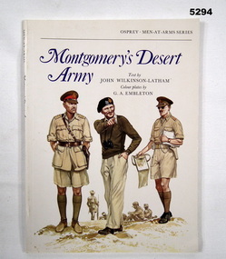 Bendigo Military Museum
Book - BOOK, WW2, NORTH AFRICA, JOHN WILKINSON- LATHAM, Montgomery's Desert Army, 1977
Colour Plates by 'G.A. EMELETON'. OSPREY MEN AT ARMS SERIES.Soft cover book. Soft cover - cardboard, blue and black colour print on front, spine and back. Front cover illustration of three army personnel on white background. 40 pages, paper, cut, plain, white. Illustrated - black and white photographs, maps and colour plates. Title page - two owner's stamps.Title page - owner's stamp, black ink, "MR. W.J. HAMMILL, A.A.I.M./ PO BOX 76, KANGAROO FLAT/ VICTORIA, 3555, AUSTRALIA,"books, history, ww2 -
 Orbost & District Historical Society
folder, Orbost Bridges - Snowy River Road Bridges, 1974 1976
This folder was compiled in October 2015 from documents, magazines. papers and photographs donated by David Jellie, engineer in charge 1974 - 1976. In early 1974, as an Engineer with the Country Roads Board, David came to Orbost as the Supervising Engineer for the construction of the new bridges which were part of an 8.4km Orbost bypass road design. This was a major project involving not only a new bridge over the Snowy River (including Lochiel Lagoon), but other bridges over Ashby’s Gulch and Watt’s Gulch. These new bridges were opened in November 1976 with the unveiling of a plaque on the eastern end of the $2.4M Snowy River Bridge. (ref. May Leatch)This item is a useful reference tool on the construction history of the Snowy River Road bridges.A white plastic folder - Orbost Bridges - Snowy River Road Bridges. it contains newspaper articles, booklets, photographs and documents relating to the construction of the Snowy River Road Bridge in 1974 -1976.on front cover - 1974 - 76 ORBOST / SNOWY RIVER ROAD BRIDGES * construction * photos * articles * plans Donated by David Jellie Oct 2015snowy-river-bridges jellie-david -
 Melbourne Legacy
Film - Video tape, Bill Roycroft, 25/8/76
This tape has not been played but from the label it is a recording from 1976, of 30 seconds duration about Legacy. Possibly it is an advertisement.As the content is unknown so significance is not known, though it is assumed to be promotional material for Legacy from 1976.White cardboard box with a light brown spool with video film.Label, client - Legacy, product - Bill Roycroft, key no - lab 1/30, record date - 25-8-76. As arranged by Tony Charltonlegacy promotion, advertisements -
 Ballarat Tramway Museum
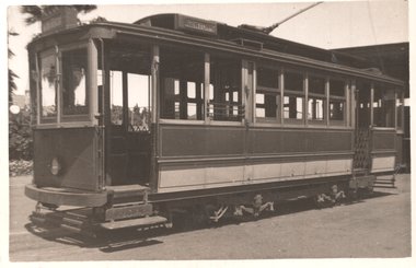
Photograph - Geelong 3 at Railway Station, Ken McCarthy, 4-2-1948
The photo shows Geelong tram No. 3 at the railway station with the destination of Newtown. Photo by Ken McCarthy 4-2-1948Yields information about the Geelong railway station terminus and tram 3.Black and white photograph with stamped details on rear.Typed on rear "No. 3 car SEC Geelong 4 Feb 1948, copyright K McCarthy, Photo No. 76". Ken Magor stamp as well" tramways, trams, geelong, tram 3, railway, railway station -
 Sunbury Family History and Heritage Society Inc.
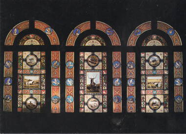
Postcard, Mark Wilson, Rupertswood Stained Glass Windows, C1980s
The colourful stained glass windows are on the first landing of the staircase in the entrance hall at Rupertswood Mansion in Sunbury.The illustrations in the windows depict scenes of Sunbury's early agricultural past.A Coloured photograph in post card format of three decorative stained glass windows. Printed on the back: THREE SIGNIFICANT STAINED GLASS WINDOWS/RUPERTSWOOD 1874-76 SUNBURY VICTORIA. PHOTO MARK WILSON/RUPERTSWOOD RESTORATION SOCIETY.rupertswood mansion, stained glass windows, rupertswood restoration society -
 Bendigo Historical Society Inc.
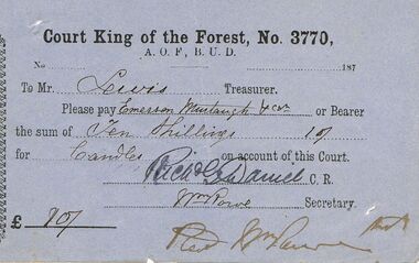
Document - ANCIENT ORDER OF FORESTERS NO 3770 COLLECTION: TO PAY
Blue coupon, dated 187-, asking Mr. Lewis, Treasurer to pay Emerson Murtaugh & Co? the sum of 10/0 for Candles. Signed by Rich. G. Daniel, C.R. and Wm Rowe, Secretary. Signed at the bottom Wm Rowe for Advertiser Aug 10 76.societies, aof, correspondence, ancient order of foresters no 3770 collection - to pay, court king of the forest, a.o.f., b.u.d., mr lewis, emerson murtaugh & co?, rich g daniel, wm rowe -
 Buninyong & District Historical Society
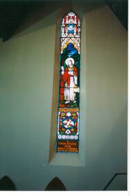
Photograph - Original Photograph, C J Brooks, Presbyterian (now Uniting) Church, Buninyong, interior, stained glass window East wall, 9/11/1991
historic building, stained glass window depicting "Christ the Light of the World."Colour photo, Presbyterian (now Uniting) Church, Buninyong, interior, stained glass window East wall. Dedication "Stuart Charles Davies Lay Preacher for 50 years. A token of Love from Family and Friends, died Feb. 1981, aged 76 years.)buninyong, church, presbyterian, uniting, stained glass, davies -
 Bendigo Historical Society Inc.
Booklet - The Civil Establishment of the Colony of Victoria for 1851
Port Phillip was first settled in 1803 and became a part of NSW in 1836. It became it's own governing colony in 1851. This statistical book lists public servants for the colony alphabetically, their role, place of employment, and a page reference to a description of the role can be found. Included positions in the fields of Government officers, Police , penal, judicial medical, ecclesiastical and education. Includes salaries for the various positions.Blue soft cover booklet of 76 pages. Titled 'The Civil Establishment of The Colony of Victoria for the Year 1851' Reproduced in facsimile from the Victoria 'Blue Book, No,1 First published in 1976 by the Public Record Office, Melbourne. Printed by C.H.Rixon, Government Printer, Melbourne civil establishment, victoria 1851 -
 Bacchus Marsh & District Historical Society
Map, Parish of Yangardook, County of Bourke 1876
The parish of Yangardook lies directly north of the township of Melton. The locality of Toolern Vale lies in the centre of this parish. A single page paper map showing the plan for the Parish of Yangardook in the in the County of Bourke. Scale 40 chains to 1 inch. The map is pasted into a bound volume containing 76 maps or plans in total. High resolution digital image stored on BMDHS computer network. Photo lithographed at the Department of Lands and Survey, Melbourne by J. Noone, 1.8.76yangardook parish maps, toolern vale victoria maps -
 Bacchus Marsh & District Historical Society
Map, 'Map of Darley' circa 1877-1897
This map shows the early laid out streets and roads for the village of Darley and the main roads and streets in the central area of the township of Bacchus Marsh. The date of the map is not known. Landmarks indicated on the map including the Anglican Church in Church Street (Gisborne Road), opposite the Presbyterian Church, and the Baptist Church at its pre-1898 Main Street location suggest the map is dated between 1877 and 1897. Landholders names can be seen on some of the allotments of land marked in this map, including the names Clifton, Cosgrove, O'Hagan, McFarlane, Nagle, O'Hagan, Simpson and Vallence.A single page paper map showing the village of Darley and the township of Bacchus Marsh. Scale 10 chains to 1 inch. The map is pasted into a bound volume containing 76 maps or plans in total. High resolution digital image stored on BMDHS computer network. darley victoria maps, bacchus marsh victoria maps -
 Bacchus Marsh & District Historical Society
Map, Mooradoranook Parish Map, County of Grant
A single page paper map showing the map for the Parish of Mooradanook in the County of Grant. Cadastral map showing land ownership. The map is pasted into a bound volume containing 76 maps or plans in total. High resolution digital image stored on BMDHS computer network. Photo lithographed at the Department of Lands and Survey Melbourne by T. F. McGauran, 27.11.06mooradoranook parish maps, mooradoranook parish plan, bacchus marsh region parish plans -
 Bacchus Marsh & District Historical Society
Map, Mouyong Parish Map, County of Grant
A single page paper map showing the map for the Parish of Mouyong in the County of Grant. Cadastral map showing land ownership. The map is pasted into a bound volume containing 76 maps or plans in total. High resolution digital image stored on BMDHS computer network. Photo lithographed at the Department of Lands and Survey Melbourne by T. F. McGauran, 9. 4. 07mouyong parish plan, mouyong parish maps, bacchus marsh region parish plans -
Moorabbin Air Museum
Manual (Item) - Wright Cyclone Series 9Gc Engines Service Manual
Description: 69 pages. Published by Wright Aeronautical Corporation. Published December 1945. AN 02-35GG-4/No. 856098N1. Parts Catalogue for Wright Cyclone Model R1820-74W and -76 Aircraft Engines Level of Importance: World. -
Moorabbin Air Museum
Manual (Item) - Hs748 (Trn) Aircraft Maintenance Manual - Book 4
Description: 500 pages. Published by RAAF. Published 5/12/1988. AAP 7211.003-2B7. HS748 Aircraft Maintenance Manual Chapter 76, 77, 78, 79, 80, 82 and 83. Level of Importance: World. -
 Ringwood and District Historical Society
Document - Extract from book "Bush Town to City" (Croydon, Victoria), Severance from the Shire of Lillydale 1952-1961
Addendum to folder of Estate Agent's notes compiled in preparation for property auction, "Shadowood", 74-76 Alto Avenue, Croydon, Victoria, 11th October, 2008. Ten pages plus map detailing the history of the severance of Croydon from Lillydale written by Robert Federick Jensen. -
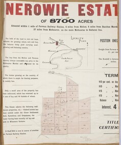 Bacchus Marsh & District Historical Society
Map, Nerowie Estate Land Sale 1910
The Nerowie Estate was a large rural property of 8,700 acres (3520 hectares) near the locality of Parwan only a few kilometers east of Bacchus Marsh. It had once formed a large part of the land owned by the pioneering Staughton family.A single page paper map showing the land offered for sale from the Nerowie Estate at Parwan near Bacchus Marsh in 1910. The map is pasted into a bound volume containing 76 maps or plans in total. High resolution digital image stored on BMDHS computer network. nerowie estate parwan, land sales parwan, land sales bacchus marsh, staughton family bacchus marsh -
![Map, Plan of Subdivision of Crown Portion 23 & parts 24-25, Parish of Korkuperrimul [1900s?]](/media/collectors/5e461d8021ea67224c82f2a1/items/675fe058304668462205d4fb/item-media/675fe0ef304668462205d7d6/item-fit-380x285.jpg) Bacchus Marsh & District Historical Society
Bacchus Marsh & District Historical SocietyMap, Plan of Subdivision of Crown Portion 23 & parts 24-25, Parish of Korkuperrimul [1900s?]
The Parish of Korkuperrimul includes a significant section of the township of Bacchus Marsh and extends in western and northern directions from the township area. The date of the subdivision indicated on this plan has not been established. The engineer's stamp on the drawing shows the firm of Muntz and Muntz who were operating under that name in the early part of the 20th century.A single page paper map showing 20 blocks of land for sale in the Parish of Korkuperrimul. Scale 100 feet to 1 inch. The map is pasted into a bound volume containing 76 maps or plans in total. High resolution digital image stored on BMDHS computer network. Stamped: 'Muntz & Muntz Civil Engineers, Architects & Surveyors, Trustees Chambers ?? Cor Collins Street and Bank Placeland sales bacchus marsh, bacchus marsh victoria maps, land sales korkuperrimul parish -
Moorabbin Air Museum
Manual (Item) - Hawker Siddeley HS 748 Model 229 Manual: Basic Part 3, HS748 Aircraft 229 Illustrated Parts Catalogue Basic Part 3 Section V
Description: 600 pages. Issued by RAAF on 08/08/1990. AAP 7211.003-4B3. HS748 Aircraft Maintenance Manual Chapters 56, 57, 61, 76, 77, 78, 80, 82, 83. Level of Importance: World. -
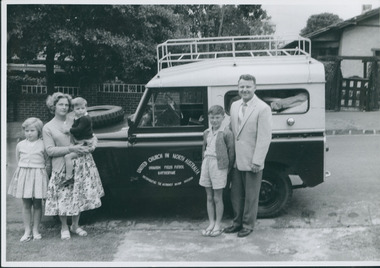 Uniting Church Archives - Synod of Victoria
Photograph, Thomas Verrier & family, 1962
Thomas Verrier (ordained 1961): Sprent (Tas.) (HM) 1956–60; Katherine (NT) 1962–65; Nightcliff (Darwin) 1966–67; Bendigo North 1968–71; Burnie (Tas.) 1971–76; Bayswater & Wantirna 1977–?.Thomas Verrier and family standing alongside the Land Rover ready to depart for Uranium Fields Patrol Katherine.Rev. Thomas Verrier and family before departure for Katherine.verrier, thomas